

GeoHaTACC

Geo-hydrological Hazards triggered by rain in Tropical Africa: a demonstrator for Rwanda to document the effects of Climate Change
Overview
Hydro-geological hazards (hereafter referred to as "GH"), such as mass movements and flash floods, are controlled by meteorological and climatic factors. Climate change is altering their frequency and intensity, although current evidence suggests that anthropogenic landscape changes, such as deforestation and road construction, play a major amplifying role. Documenting these processes more comprehensively, in particular by creating inventories of well-dated and localised events, and linking them to triggers, is crucial to better forecasting them.
Tropical climate regions in Africa are particularly impacted but suffer from a lack of data: GHs are poorly studied and rainfall measurements are not dense and/or accurate enough. To study the impact of climate change in these regions, it is necessary to build spatio-temporal inventories associating the type of GH, the spatial location, the date of occurrence, and the properties of the triggering forcing - in this case rainfall, in terms of intensity or accumulation over several days, and this ideally over a wide range of landscapes and climatic conditions.
For this purpose, spatial remote sensing is essential, on the one hand to locate and date the GHs, and on the other hand to estimate the associated rainfall fields. However, remote sensing alone does not make it possible to identify essential information, such as the exact time when the GHs occurred, nor to associate a quality criterion with the inventory. The products of satellite remote sensing must therefore be verified by other sources of information, such as the media.
GeoHaTACC therefore aims to develop a toolbox that will enable scientific and operational communities to identify the consequences of climate change on meteorological risks in Central Africa. The system will be operated via a webservice-type demonstrator in a heavily impacted area (Rwanda) and the information produced will be disseminated to local and international users. The whole system will be developed to be easily transposable to other territories and meteorological forcing conditions, and to be able to support a scaling up of the whole tropical Africa.
Methodology
Development of a generic toolkit - using data from international partner programmes (Copernicus EU, GPM/NASA-NOAA, TPM - ESA) - allowing :
- to detect, locate and date GHs from radar and optical satellite images;
- to verify and complement satellite detections by extracting information from logs;
- to analyse the microwave satellite data to extract the properties of the triggering rain;
- to operate the system systematically via a demonstrator so that the inventories created can be disseminated and visualised.
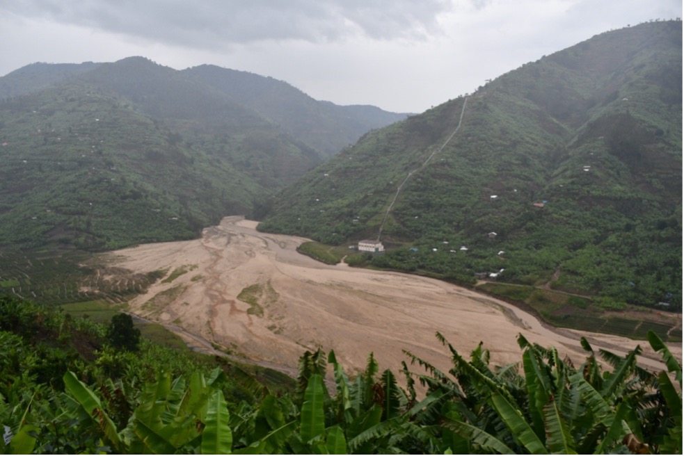
Example of a typical hyper-concentrated flood in Rwanda. © O. Dewitte & B. Smets, RMCA, Tervuren
Application site(s)
Rwanda, East Africa
The demonstrator will be based in Rwanda, on a sector of the western branch of the East African Rift where the natural and man-made landscapes are diverse, with marked local climatic variations. Moreover, thanks to a long-standing partnership, the project partners have already developed a strong expertise in the study of natural hazards and associated disasters in this area.
Data
Satellite
Detection of geo-hydrological hazards (GH):
- Sentinel-1 and -2
- Landsat-8/9
- PlanetScope
Rain fields:
- GPM/NASA data
Other
Digital press and social media (Twitter)
Results – Final Product(s)
GeoHaTACC will develop an operational demonstrator that meets the needs of a user community identified locally (Rwanda) and internationally (CRED), and which will be trained in the system put in place:
- Web interface providing data and tools to observe and quantify the impacts of climate change in terms of natural hazards in a little-studied region of the world;
- Open access methodologies and tools, generic and transferable to other regions of the world.
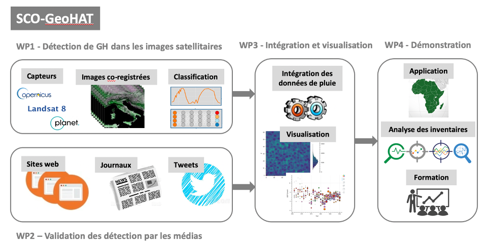
GeoHaTACC is organised into 4 main areas of work. © GeoHaTACC
References
| GeoHaTACC on GEO Knowledge Hub, a long lasting digital repository created by the Group on Earth Observations: https://doi.org/10.60566/5tate-whb81 |
- Rengers, F.K., et al. 2016. Water Resources Research 52, Model simulations of flood and debris flow timing in steep catchments after wildfire
- Depicker, A., et al. 2021. Nature Sustainability, Historical dynamics of landslide risk from population and forest-cover changes in the Kivu Rift
- Froude, M.. J., Petley, D.N., 2018. Natural Hazards and Earth System Sciences 18
- Cendrero, A., et al. 2020. Earth's Future, 8(5), Anthropocene Geomorphic Change. Climate or Human Activities?
- CRED UNDRR, 2020. Human cost of disasters, an overview on the last 20 years
- Monsieurs, E., et al. 2018. Landslides 15, Landslide inventory for hazard assessment in a data-poor context: a regional-scale approach in a tropical African environment
- IPCC, 2021. Climate Change 2021: The Physical Science Basis
- Jacobs, L., et al. 2016. Natural Hazards 84, Reconstruction of a flash flood event through a multi-hazard approach: focus on the Rwenzori Mountains, Uganda
- Jacobs, L. et al., 2019. Science of The Total Environment 670, The geo-observer network: A proof of concept on participatory sensing of disasters in a remote setting
- Deijns, A., et al., 2021; AGU Fall Meeting 2021, Landslide and Flash Flood Timing from Satellite Radar Imagery in the Western Branch of the East African Rift
- Stumpf, A., et al., 2014. ISPRS Journal of Photogrammetry and Remote Sensing 95, Surface reconstruction and landslide displacement measurements with Pléiades satellite images
- Marc, O., et al. 2018. Earth Surface Dynamics 6, Initial insights from a global database of rainfall-induced landslide inventories: the weak influence of slope and strong influence of total storm rainfall
- Marc, O., et al. 2019. Geophysical Research Letters, 46(20), Spatial Patterns of Storm-Induced Landslides and Their Relation to Rainfall Anomaly Maps
- Déprez, A., et al. 2020. ISPRS Congress 2020, Nice, France. IMCLASS – A user-tailored machine learning image classification chain for change detection or landcover mapping
Related projects
- Data-Terra Research Infrastructure / ForM@Ter Data Centre
- GuiDANCE: GeohazarDs in AfricaN CitiEs: patterns, rates and sustainability in urban sprawling contexts
Project news
- 22/03/2024: Presentation of the GeoHaTACC project and its progress at the 12th SCO France Quarterly Meeting "Coping with natural disasters"
- 11/01/2024: GeoHaTACC or satellite optical data to detect geo-hydrological hazards