

SCOFrance
Useful linksProject page
Key wordsGeo-hydrological hazards, landslides, flash floods, extreme rainfall, high-resolution detection Sentinel-2, Rwanda
GeoHaTACC or satellite optical data to detect geo-hydrological hazards
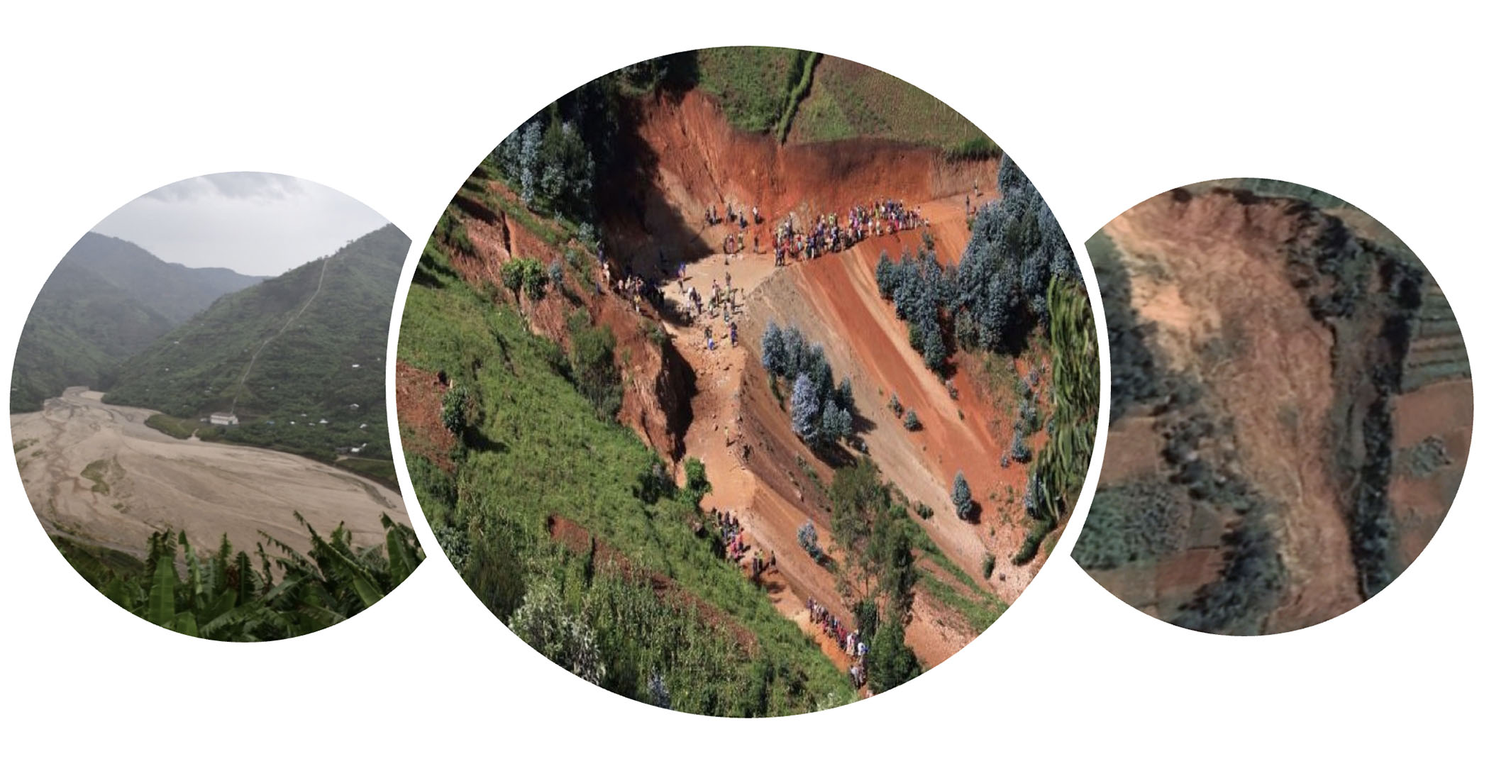
By geo-hydrological hazards we mean landslides and flash floods, phenomena that can be violent and whose impact is particularly marked in the Tropics. While the occurrence of intense rainfall is the main triggering factor, changes to the landscape brought about by human activity can be a major aggravating factor. Added to this are the impacts of climate change, which are modifying the frequency and intensity of these events.
Supported by the School and Observatory of Earth Sciences (Ecole et Observatoire des Sciences de la Terre EOST) and a Belgian research team from the Royal Museum for Central Africa (RMCA), the GeoHaTACC project focuses on Rwanda, an area of the East African Rift that is particularly prone to these hazards, which recur every rainy season.
The first year of the project enabled the international team to lay the foundations of its automatic methodology for detecting and classifying these rainfall-triggered hazards. "On the French side, we are responsible for implementing the satellite component co-developed with our Belgian colleagues to identify and map geo-hydrological hazards using long time series of Sentinel-2 optical images. This includes the development of a processing chain combining innovative data cube technologies, time series analysis, artificial intelligence and massive computing. Our Belgian colleagues are developing two innovative detection approaches: one involves using Sentinel-1 radar imagery as a complementary tool to the detection using optical data, and the other involves extracting information from the media (online press, social networks, websites) using artificial intelligence and natural language processing. They are also contributing through their knowledge of Rwanda, their databases and their local scientific contacts. Together, we are also integrating existing meteorological satellite data, which we are analyzing to understand the rainfall conditions that trigger these phenomena",explains Jean-Philippe Malet, geophysicist at EOST and project leader. Let's take a closer look with him and his team at the work that has already been done.
✅ Building the digital geospatial base
Having to start by creating a geospatial database, "We were starting from very little", explains Aline Déprez, scientific computing engineer. "We worked on harmonizing several high-resolution topographic databases, digital surface models and geological maps, which we scanned and then digitized to obtain homogeneous data. Then we did the same to identify the most relevant meteorological data".
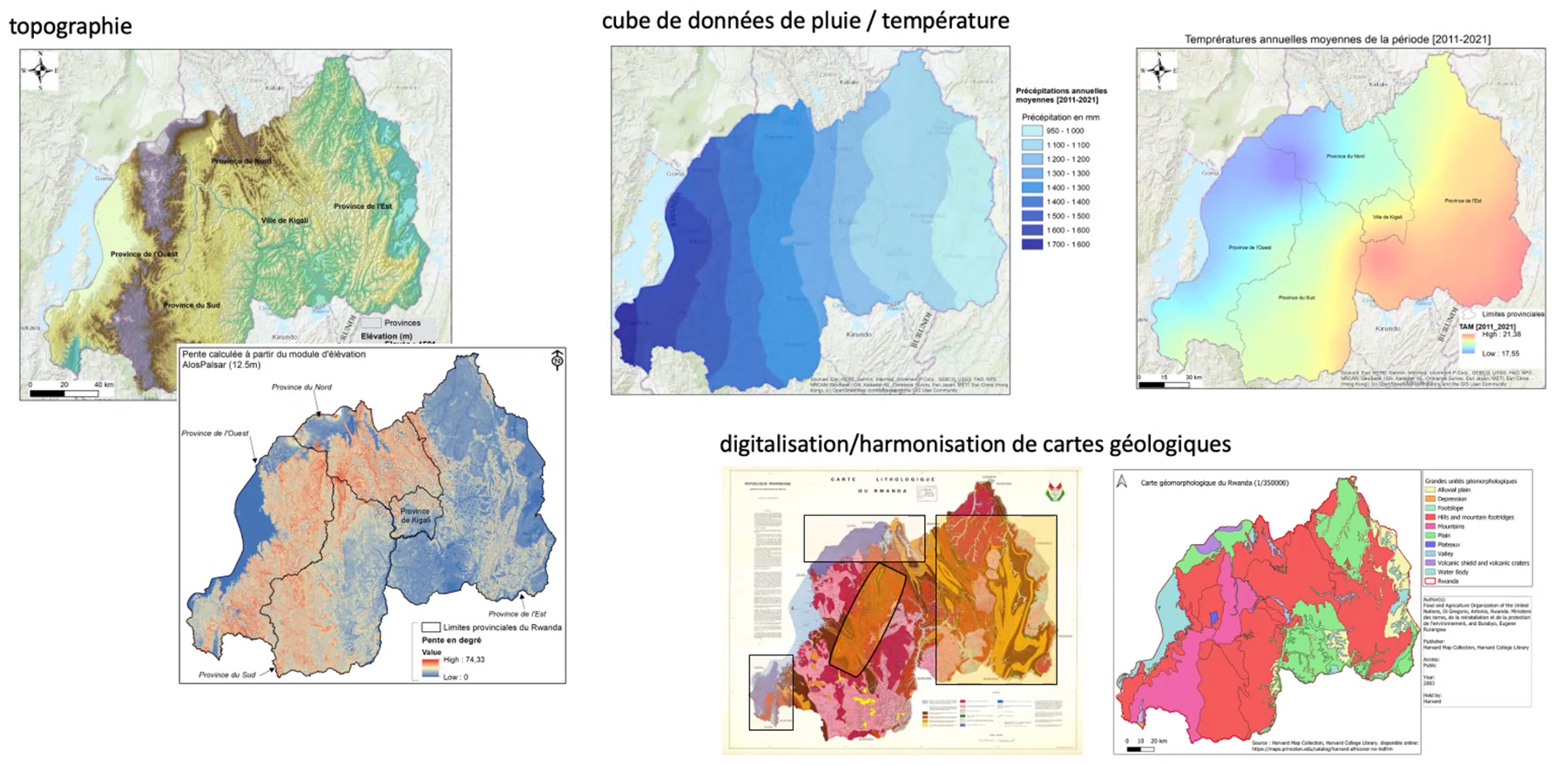
▲ Collection, harmonization and georeferencing of various sources of geospatial data. © CNRS/EOST & RMCA (A. Déprez, J. Jean-Baptiste, O. Dewitte & B. Smets)
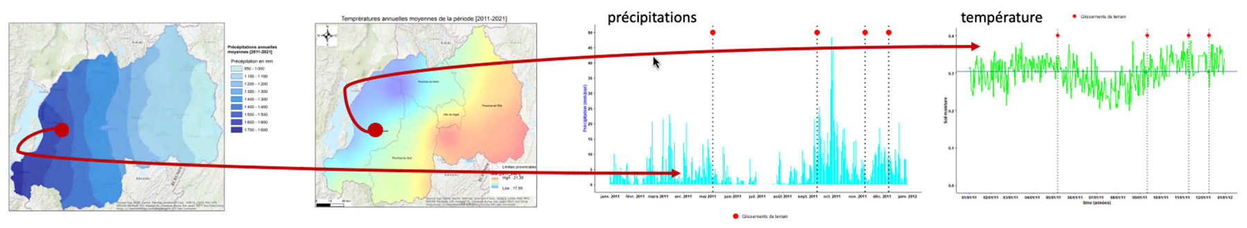
▲ The project has built a technological architecture based on a data cube framework that enables multi-source and heterogeneous data to be integrated and exploited. The example above links temperature data, precipitation data for a given spatial location (one or more pixels) and the date on which a geo-hydrological hazard is triggered. At the end of the project, this capability will be available online in the form of a web service for cross-referencing different types of information. © CNRS/EOST (D. Michéa et J.-P. Malet)
✅ Automatically produce geo-hydrological hazard inventories
In a second stage, the team created a historical inventory of landslides and torrential floods since 2016 using Sentinel-2 satellite data. These detections complement existing geomorphological inventories, most of which were carried out by RMCA teams and their Rwandan partners.
The project team has been working on this automatic detection at pixel level for several years, so the methodology is now well consolidated. Essentially, the system generates cubes of 6 spectral indices derived from the radiometric bands of optical satellites (such as the NDVI vegetation index). By calculating the cumulative sum over time of each index per pixel, variations (positive/negative) are analyzed to detect sudden changes. A significant variation in an indicator (prominence) makes it possible to identify and map abrupt changes at pixel level. Next, a supervised classification method using machine learning is used to identify areas (segments) that have undergone a change over the period under consideration and to generalize the information spatially. The method takes topographical criteria into account, making it possible to distinguish geo-hydrological hazards from other possible changes (deforestation, urbanization).
The concept of the method was developed by Axel Deijns, a PhD student working on the project at RMCA, and the methodology was operationalized for scale-up by David Michéa, a scientific computing engineer at EOST.
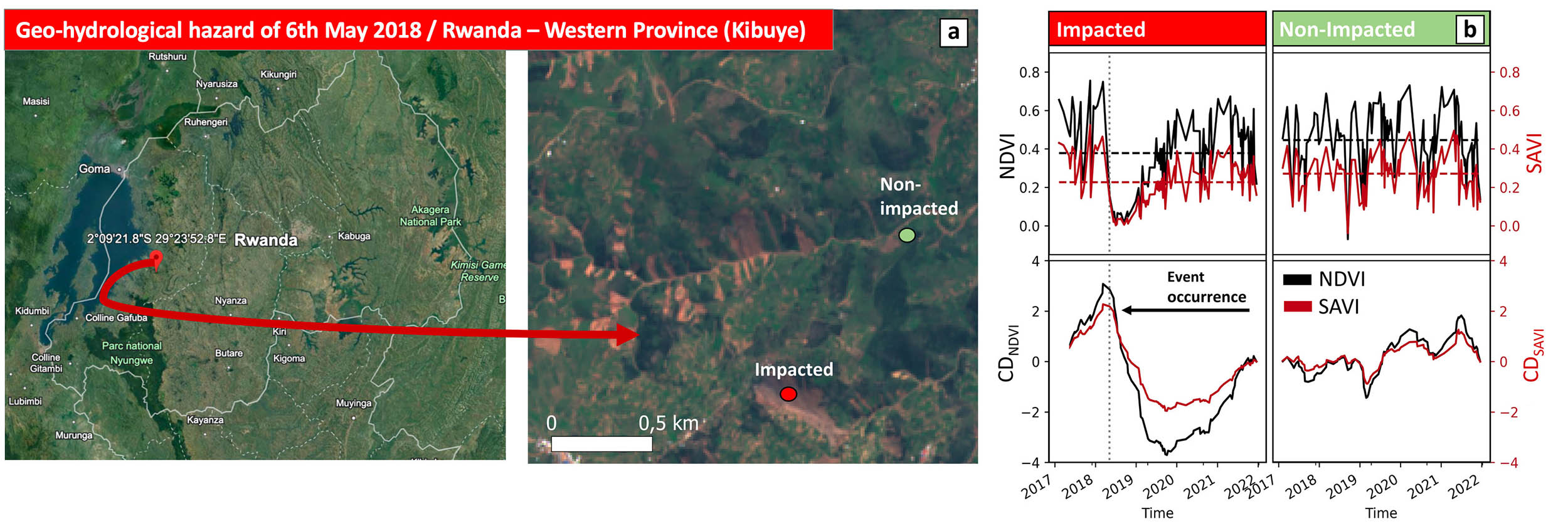
▲ Index curve derived from time series of optical satellite images. On the left of the graph, the drop in the curve is clear and corresponds to a geo-hydrological hazard event. On the right, as the 'drops' are recurrent, they reflect a seasonal change and not a geo-hydrological hazard. © RMCA & EOST (A. Deijns, A. Déprez)
Towards systematic, regional detection using Sentinel-2
Several tests on Sentinel-2 tiles outside Rwanda, in areas with digital databases such as Burundi, the Democratic Republic of Congo and Tanzania, have confirmed the effectiveness of the methodology. Jean-Philippe Malet confirms: "We can now envisage quasi-systematic and incremental processing over several Sentinel-2 zones and add the new data to the cubes, thus enabling regional detections".
In 2024, the project team will work on exploiting meteorological data to understand, at first order, the forcing conditions to these hazards, in terms of thresholds, intensities and type of rainfall, in order to identify trends. The team, via the thesis work of Bram Valkenborg (RMCA), would like to develop a procedure enabling the identification of hazards described in newspapers and social media, based on the analysis of online articles using artificial intelligence methods adapted to natural language analysis. Ideally, this would make it possible to optimize satellite detection for certain events mentioned online.
All that remains to be done is to scale up the calculations. Jean-Philippe Malet points out that this "will be achieved through collaboration between the project and the Data-Terra research infrastructure via its THEIA and ForM@Ter thematic clusters". Delivery of the interface to the current demonstrator is scheduled for the first half of 2025 in the form of an operational and automatic web service, which will be introduced to Rwandan institutions such as universities, the space agency, Meteo Rwanda and MINEMA.
According to the project leader, "this methodology is now ready to be scaled up and used for automatic detection in various regions of the world, subject to parameterization by physio-geographical zone. In a second phase, once the database has been sufficiently developed and validated, the geo-hydrological hazard inventories could be fed into a global repository, useful both for scientific research into understanding climate change in terms of the frequency and intensity of these hazards, and for operational needs in terms of risk management. But let's not rush, first things first!”
Scientific references:
-
Deijns, A.A.J., Dewitte, O., Thiery, W., d'Oreye, N., Malet, J.-P., Kervyn, F., 2022. Timing landslide and flash flood events from SAR satellite: a new method illustrated in African cloud-covered tropical environments. Natural Hazards and Earth System Sciences 22, 3679-3700. doi:https://doi.org/10.5194/nhess-22-3679-2022
-
Deijns, A.A.J., Michéa, D., Déprez, A., Dewitte, O., Kervyn, F., Thiery, W., Malet, J.-P., in review. A semi-supervised multi-temporal landslide and flash flood event detection methodology for unexplored regions using massive satellite image time series. ISPRS Journal of Photogrammetry and Remote Sensing.
Project participants: Axel Deijns, Aline Déprez, Olivier Dewitte, Jean-Philippe Malet, David Michéa, Benoît Smets, Bram Valkenborg