

AirCrowd
.")
Air quality monitoring with a reproducible, scalable solution complemented by participatory measurements
Overview
AirCrowd aims to develop an innovative technical solution as well as a participative approach to respond to the worsening of air pollution in Southern countries, with its major health, environmental and economic consequences for the population and the territories concerned. The demonstrator is being implemented in the South Provence-Alpes-Côte d'Azur region with the ultimate goal of applying the solution to countries in the Global South.
Air pollution poses a major threat to health through respiratory and cardiovascular diseases, which are responsible for nearly 7 million deaths worldwide each year. The vast majority of victims (90%) are found in low- and middle-income countries, particularly in Asia and Africa. The main causes are fine particulate matter (PM2.5 and PM10), nitrogen dioxide (NO₂) and ozone (O₃), all of which are produced by human activities. With rapid urban growth—sometimes exceeding 5% per year—and the effects of climate change exacerbating pollution peaks, episodes of air pollution are becoming more frequent and more intense.
In urban areas, pollution regularly exceeds WHO thresholds, exposing vulnerable populations such as children, the elderly, and frail patients to particular risk. However, the data available on air quality remains insufficient in most cities: ground-based sensors, although reliable, are expensive and limited in number, while satellites offer extensive coverage but are still too inaccurate at the urban scale. These shortcomings hamper the ability of public authorities to take action and can result in local responses that are inadequate and ineffective.
The AirCrowd project aims to develop an innovative, low-cost technical solution to make air quality data production more accessible and easier to deploy. The South Provence-Alpes-Côte d'Azur region is serving as a demonstration area, particularly in the municipality of Gardanne and around the Étang de Berre lagoon. The project is based on implementation conditions similar to those encountered in southern countries, working only with data that is available or can be deployed locally and involving local actors such as FabLabs to ensure the implementation and sustainability of the solutions.
AirCrowd's objective is to test an approach in the PACA region that can be adapted and replicated in other contexts, particularly in underserved regions where access to monitoring infrastructure remains limited. By combining technical innovation, local participation, and low cost, the project paves the way for air quality monitoring that is detailed, affordable, tailored to local needs, and inclusive of local populations.
Approach and methodology
The project aims to measure, at low cost, air quality in urban areas by combining satellite data and terrestrial data from a network of micro-stations for environmental measurement, to observe the impact of ambient air quality on the health of residents, to involve the population and local stakeholders in a collective approach, to encourage changes in lifestyle habits and individual behaviors, and ultimately to encourage public action.
The value proposition, in comparison with existing solutions (industrial air quality measuring stations which are expensive and difficult to maintain, satellite measurement with low precision and dependent on aerology), is to merge different data sources (terrestrial and spatial environmental data, local health data), to produce high-resolution maps (digital twin) from these data, and to model alternative urban development strategies based on these datasets and serious games.
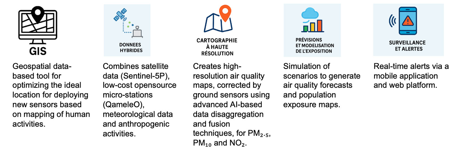
Figure 1: AirCrowd Solution
Application site(s)
Gardanne and Étang de Berre in the PACA region (France)
Map © Copernicus Sentinel-2 | 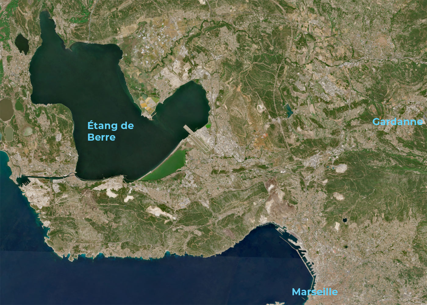 |
Data
Satellite
- Copernicus Sentinel-5P Level 2
- Copernicus Atmosphere Monitoring Service (CAMS)
Other
- TeleCense data : building footprint from Sentinel-1 & 2, distribution of human activities (residential, non-residential, industries, transport), estimation and projection of the population , distribution by gender and age groups
- Road, air and maritime traffic data
- Data from the Open Source QameleO micro-stations, designed by the IRD in the project and tested in Dijon and Dakar
- Weather data: temperatures, rain and wind (ERA5)
- Health data : IRD study of the AirQali-4-AsmAfri (A4A) project which establishes the relationship between air pollution and asthma among children in Benin
Results – Final product(s)
Faced with major health challenges linked to air pollution, AirCrowd combines several innovations to develop a demonstrator in mainland France that can be replicated in countries in the Global South:
- A network of micro-stations for the spatialized measurement of urban pollution, an open source model built on site (FabLAB), low cost and locally repairable.
- A software for analyzing satellite atmospheric data and assisting with the positioning of the micro-stations and the calibration of sensors.
- A platform for aggregating environmental, terrestrial and satellite data, as well as health data, generating air quality maps and spatialized indicators of pollution and health risk.
- Modeling and scenario tools (serious game) for awareness and action by local public and private authorities.
Copernicus data and the TeleCense service are hosted on sobloo , the Airbus and Orange cloud platform. The service offered by the project (platform for aggregating environmental, terrestrial and satellite data, and health data, generating air quality maps and spatialized indicators of pollution and health risk) will also be hosted on sobloo or on the new Copernicus Data Access Service platform.
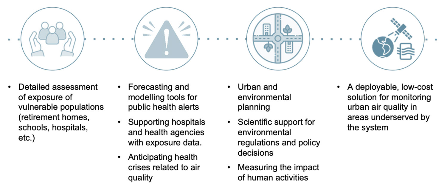
Figure 2: Expected impacts of the AirCrowd solution
References
Ngom, Bassirou, Moussa Diallo, Madoune Robert Seyc, Mamadou Simina Drame, Christophe Cambier, et Nicolas Marilleau. « PM10 Data Assimilation on Real-time Agent-based Simulation using Machine Learning Models: case of Dakar Urban Air Pollution Study ». In 2021 IEEE/ACM 25th International Symposium on Distributed Simulation and Real Time Applications (DS-RT), 1‑4. Valencia, Spain: IEEE, 2021.
Laëticia Gutman, Vanessa Pauly, Veronica Orleans, Damien Piga, Yann Channac, Alexandre Armengaud, Laurent Boyer, Laurent Papazian, 2022. Impact of chronic exposure to air pollutants on the incidence and mortality of Acute Respiratory Distress Syndrome (ARDS) in the Region South Provence-Alpes-Côte d’Azur
Integrating Care to Prevent and Manage Chronic Diseases: Best Practices in Public Health, OECD. OECD Publishing, Paris, 2023
Related projects
- MASK@PACA, project FEDER-FSE 2014-2020 - Call PI2c-2017
- AIRQALY-4-ASMAFRI “Air quality and quality of life for asthmatic children in Africa” (IRD, Richard Lalou 2021-2024)
Project news
- 🎥 18/06/2026: Presentation of the xxx project and its progress at the 21st Quarterly Meeting of SCO France “Air Quality: A View from Space”