EOLyd
Earth Observation data to estimate the loss of yields due to drought
Overview
Context
Due to its position in an arid and semi-arid zone, Morocco faces different challenges in relation to climate change: aridity, spatiotemporal scarcity and irregularity of water resources, recurrent droughts, desertification, etc. This setting has a considerable impact on agricultural production, which is an important contributor to the national economy and it is strongly dependent on climate conditions. Historically, Morocco has experienced several years of drought with greater frequency and with high intensity. These droughts have disastrous impacts on the national economy because of the strong relationship between the contribution to the country’s overall gross domestic product from agricultural GDP and the amount of annual precipitation.
The use of indices and indicators derived from earth observation becomes nowadays a fundamental tool for agricultural drought monitoring and assessment. Satellite imagery allows the national and local assessment and monitoring of crops, drought early warning, yields forecasting and quantification of climate change impacts on the agricultural season.
Objective
EOLyd aims to combine several earth observation derived data sets and existing statistics and measurements that characterize relevant components of the hydrologic cycle related to drought in order to assess and anticipate losses of cereal productions caused by drought in non-irrigated agricultural areas in Morocco. That will support various drought-related decision makers (mainly companies of agricultural insurance and concerned departments of the Ministry of Agriculture) and contribute to elaboration and implementation of adaptation plans and mitigation activities.
Specifically, this study aims to generate a “crop production loss index” by using high-resolution satellite data combined to the available in-situ data at the parcel level. Based on the historical processed data, the index should estimate the production loss generated by each drought event for a current period. The expected results can help the insurance companies and the concerned Ministry to save time and budget by evaluating the damages caused by drought directly by using gridded maps of the index instead of preparing conventional surveys.
Methodology
In order to provide the main users by an index of crop production loss before the end of the agricultural season, the methodology integrates drought monitoring service from an existing platform as well as the new service provided by the project using high spatiotemporal resolution data (Sentinel-2).
Existing platform (CDI) :
CRTS has recently developed a greeded Composite Drought Indicator CDI based on a combination of four different parameters derived from various satellite-based earth observation products that are generated on a monthly basis to produce CDI time series over Morocco at 5 km resolution. This has been done in the framework of a global project (Land Data Assimilation System, LDAS) financed by the World Bank with the technical support of the American space agency (NASA) and the National Drought Mitigation Centre of the University of Nebraska.
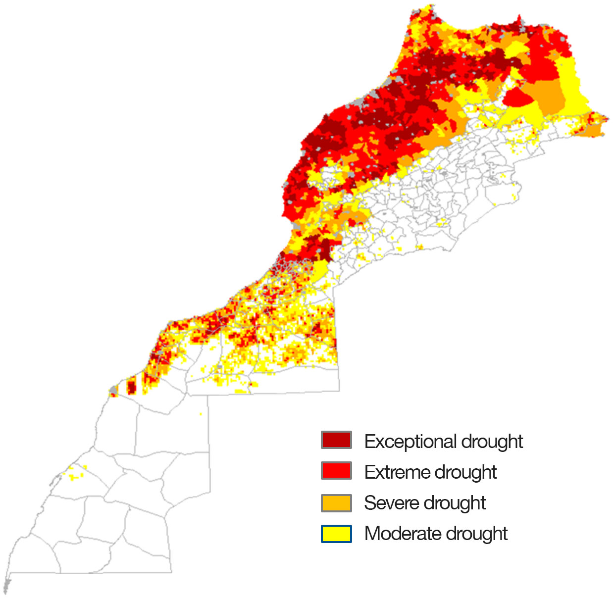
The CDI approach represents a remote sensing-based drought monitoring tool that incorporates information related to precipitation, evapotranspiration, land surface temperature (as a proxy to soil moisture), and vegetation index anomalies. Figure 1 below shows an example of a CDI map generated for February 2022.

Figure 1: Composite drought indicator (February 2022) © CRTS
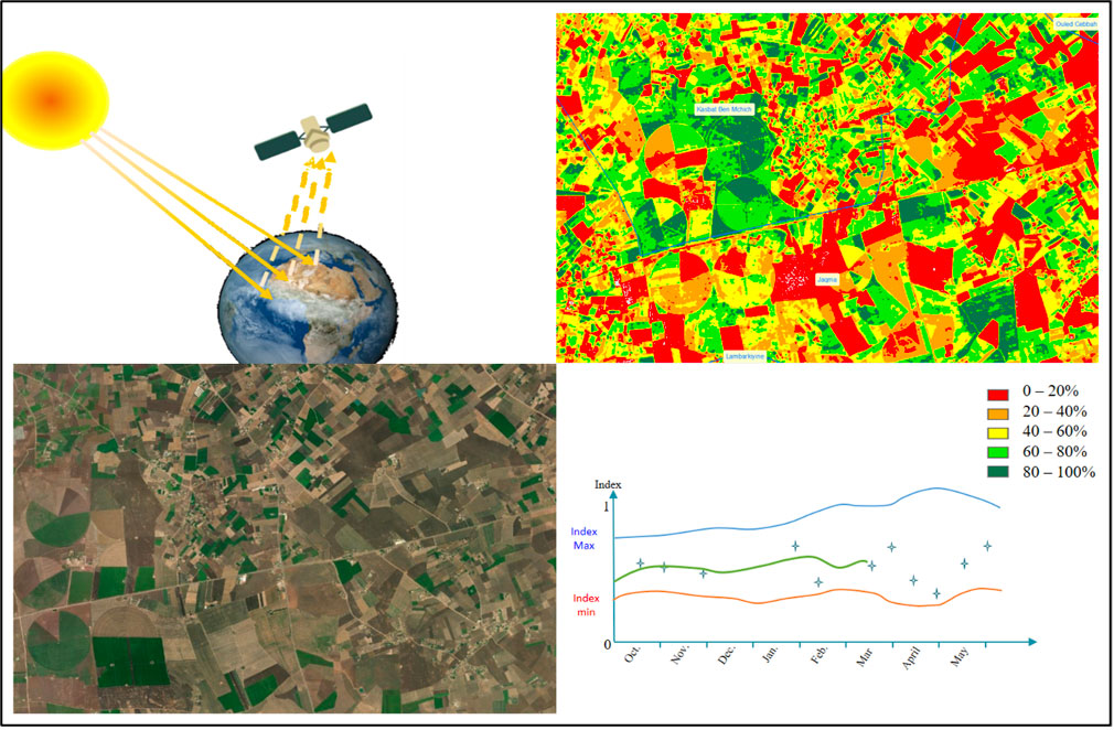
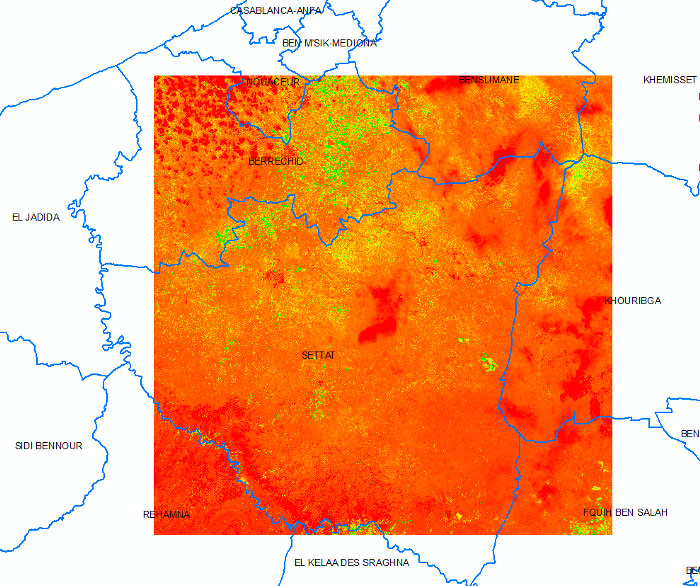
The SCO EOLyd project aims to combine the monthly produced maps of CDI during the agricultural seasons (October to April) with detailed maps of vegetation indices calculated during specific periods of the season at 10 m resolution, in order to estimate the loss of cereal production.
Implementation of the EOLyd service :
- A first step consists on preparation and processing of historic existing Sentinel-2 data on the studied area in different phases of the agricultural cycle to calculate specific parameters of vegetation growth (fCover, fAPAR…).
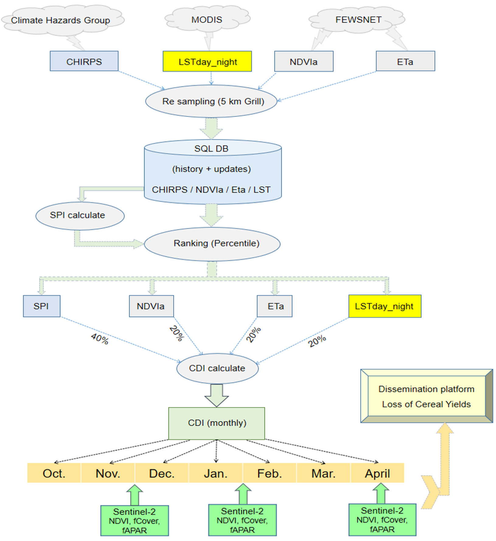
- The second phase consists on an analysis of the generated parameters maps, the CDI maps and the ancillary data (global production and specifically cereal yields from partners) in order to find the correlation parameters between the values of remote sensing indices (fCover, fAPAR and CDI) and the yields /production losses. Figure 2 shows the main methodological steps proposed in the present study.

Figure 2: Flowchart of the project methodology. CHIRPS: Climate Hazards Group InfraRed Precipitation with Station. FEWSNET: Famine Early Warning Systems Network. LST: Land Surface Temperature. NDVIa: Normalized Difference Vegetation Index anomalies. Eta: Evapotranspiration anomalies. SPI: Standardized Precipitation Index. CDI: Composite Drought Index. fCover: fraction of green vegetation cover. fAPAR: fraction of Absorbed Photosynthetically Active Radiation. © CRTS
This service can be considered as an operational tool based on satellite data allowing the delivery of periodic information on agricultural season to decision makers and agriculture managers. The proposed approach has several advantages: an objective tool based on independent observations, the possibility of covering large areas, savings in terms of time and costs compared to field surveys, etc.
The reports and maps of drought impacts will support decision makers at local scale to plan the adequate strategies in order to mitigate these impacts. For example, identifying farmers with agricultural insurance policies presenting a high crop yield loss and decide who can benefit from insurance compensation against climate hazards.
Application site(s)
Data
Satellite
The first part of the project will be based on the CDI platform, which consists on the use of different satellite based indices to generate one single composite drought indicator monthly during agricultural seasons at national scale. This platform is operational and CDI maps are generated periodically using a weighted combination of different parameters extracted from satellite data: SPI from CHIRPS data at 5km resolution, Land Surface Temperature from MODIS, NDVI anomalies, and Evapotranspiration anomalies.
Concerning the drought impact assessment and anticipation of cereal production losses, we plan to use data from the existing operational services (Copernicus, Geoportail...) at high spatiotemporal resolution:
- Sentinel-2, 10 m spatial resolution
- Landsat, 30 m spatial resolution
Other
- Yields available locally (historical and current)
- Land use in the studied zone (historical and current)
- Other data collected from the ground (climate, soils, land use, human activities, etc.)
Results - Final product(s)
- Monthly drought maps generated during the agricultural seasons and shared with end users.
- Dissemination platform developed in the framework of the project (Expertise/Consultant) for operational monitoring.
- Maps presenting the loss of cereal production of the studied agricultural season.
- Documentation (periodic bulletins and meeting reports) presenting the main results.
References
Bijaber N., El Hadani D., Saidi M., Svoboda M.D., Poulsen C.C., Hain C.R., Wardlow B.D., Yessef M. (2017b). Suivi mensuel de la sécheresse au Maroc par techniques basées sur l'indice composite. GéoObservateur n°23, Rabat, Maroc. Pages 25-37.
Related project(s)
Developing a Remotely Sensed Drought Monitoring Indicator for Morocco in the framework of LDAS project financed by the World Bank with the technical support of the American space agency (NASA) and the National Drought Mitigation Centre of the University of Nebraska.


