

Monitoring the Gold Coast

OVERVIEW
Since 1901, global sea level has risen approximately eight inches, exacerbating the erosion and inundation of coastal ecosystems around the world. In Australia, where some 85% of residents live on the coast, an increase in the frequency of coastal flooding events (resulting from higher background sea level) has the potential to cause extensive damage. The Australian coastline is protected against coastal erosion by natural beaches; however, beaches may only offer limited protection following severe storm events, as they can take many years to recover.
In June 2013 after three years of storms, the Gold Coast City Council in Australia launched its "Three-Point Plan for Coastal Protection", part of its high-profile 10-year Ocean Beaches Strategy. In support of this plan, cameras along the Gold Coast frequently map waterlines to support erosion/accretion assessments. However, the Coastal and Marine Research Centre (CMRC) at Griffith University highlighted that gaps in this data present challenges for advancing research in post-storm breach recovery in the Gold Coast and surrounding areas.
Telespazio UK, with support from the CMRC, have sought to address these data gaps as part of an ESA-Future Earth Demonstrator Project: “Satellite Monitoring for Post-Storm Beach Recovery”. This project presents the development of a Proof-of-Concept (PoC) automated methodology for waterline extraction, using Sentinel-1 Synthetic Aperture Radar (SAR) imagery and tidal data to investigate post-storm beach recovery by assessing accretion/erosion, subject to whether waterlines move shoreward (erosion) or offshore (accretion).
Application site(s)
|
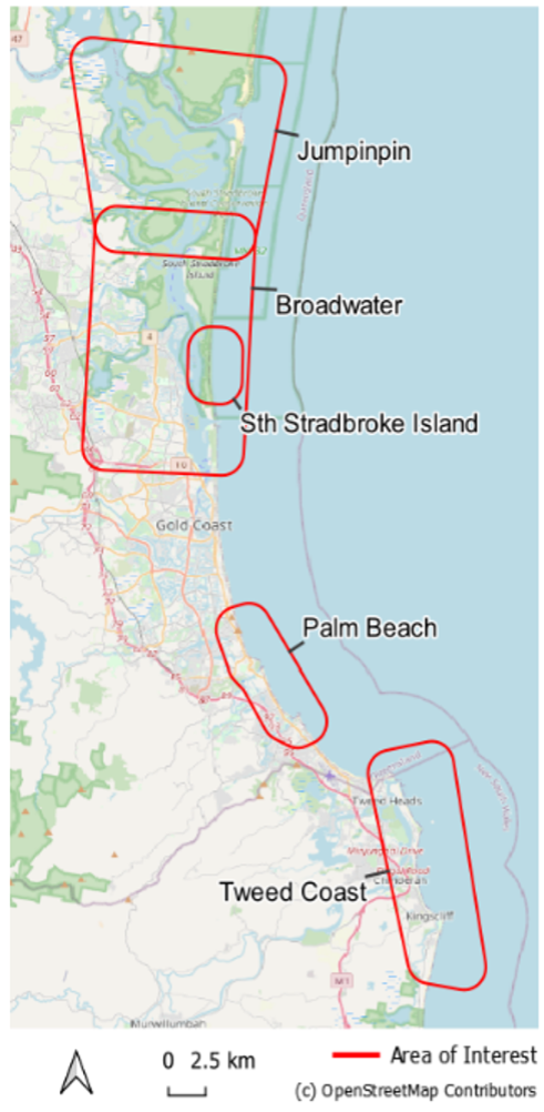
Gold Coast, Australia Following discussions with the CMRC, we selected five study areas of particular interest along the Gold Coast and surrounding areas: Jumpinpin, Broadwater, Stradbroke Island, Palm Beach and Tweed Coast (Figure 1).
▶︎ Figure 1. Areas of Interest |
 |
DATA
Satellite
- Sentinel-1 SAR
- Données ESA Sea State CCI (L3 & L4 products)
Other
- Queensland Government Southport tide gauge near real-time recordings
- Gold Coast wave buoy (gaps filled by CSIRO modelled data), Queensland Government
- OpenStreetMap vector data
- CoastSat transect lines
RESULTS - FINAL PRODUCTS
-
StoryMap Web
Telespazio UK produced an online demonstrator using web based StoryMap (Figure 2). Using the StoryMap, users can explore an overview of the project and navigate through instances of waterline extraction and analysis for investigating patterns of post-storm beach recovery.
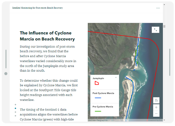
Figure 2. Screenshot of ArcGIS StoryMap. Pre (green) and post (blue) storm waterline variation at Jumpinpin in response to Cyclone Marcia.
-
Proof-of-concept Automated Waterline Detection
Telespazio UK have successfully developed a Proof-of-Concept (PoC) automated processing chain for identifying changes in waterlines using Sentinel-1 imagery and tidal state data. Our innovative approach illustrated promising results, demonstrating many expected changes in waterlines across each of the study areas in response to storm events. The solution provides flexibility for implementation under projected future climate change scenarios (through tide height projections) for any coastal environment in the world with minimal setup costs.