

MARE

High Resolution Drought Monitoring
Overview
Context
Context
The Mediterranean is one of the most vulnerable regions to climate change, with projected temperature increases of 2.2–5.1 °C and precipitation decreases of 4–27% by 2080–2100. These changes will increase evapotranspiration and reduce water availability.
👉 Higher temperatures will reduce soil moisture and increase crop water demand, particularly affecting rainfed agriculture through yield losses and a higher risk of crop failure.
👉 The increased variability of rainfall and evapotranspiration rates will further intensify competition for limited water resources within rural areas.
Drought monitoring has historically depended largely on precipitation data. However, indexes based on precipitation often require dense and long meteorological station records, have a coarse spatial resolution, and its values are often accompanied by high uncertainties. Hence, its values are strongly tied to in situ measurements.
Soil moisture is a fundamental variable for early drought detection because it can monitor drought conditions up to one month before vegetation-based indices, which only show stress once plants are already affected. Current operational Soil Moisture products (such as Copernicus Land) provide soil moisture products at a low resolution (1 km), which is not suitable for irrigated agriculture.
The MARE solution
In this context, the MARE (Monitoratge de la sequera a Alta Resolució Espacial) project provides weekly soil moisture and drought index products at a 100 metres resolution, enhancing irrigation management and crop yield estimates. In addition,
MARE has developed pilot soil moisture maps at 5 m resolution using data from the Catalan Government’s second satellite mission, Menut, demonstrating the ability to monitor soil moisture variability within individual fields.
► Comparison of optical and a 5-meter resolution MARE Soil Moisture map over a section of the Ebro delta using data from Menut satellite mission (IEEC, ICGC, Generalitat de Catalunya, acquired by Open Cosmos). © isardSAT. | 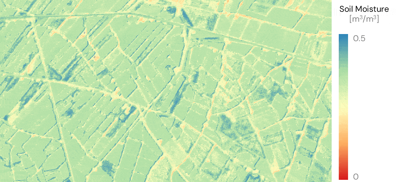 |
MARE has been developed by isardSAT, a space R&D expert on satellite technologies, missions and algorithms design for climate and environment applications. It has been funded by Generalitat de Catalunya and coordinated by the Institute of Space Studies of Catalonia (IEEC) with the collaboration of the Cartographic and Geological Institute of Catalonia (ICGC).
Application site(s)
Catalonia, Spain:
Comunitat de regants d'Aigua Segarra-Garrigues
Alt Penedès i Terres de l'Èbre
Data
The MARE project integrates data from various Earth Observation missions. By developing advanced processing algorithms, the project generates precise soil moisture and drought indices, which have been thoroughly validated using in-situ sensor data.
Satellites
SMOS and SMAP (L-band passive data)
Landsat 7, 8 and 9
Menut
Results - Final product(s)
👉 Freely available, the MARE product is an interactive drought and soil moisture monitoring tool at a field scale (less than 100 m), which provides weekly maps over the studied areas. This data allows to assess of the impacts of periods of a lack of rainfall and extreme temperatures on crops. By revealing localized moisture variations within individual fields this tool facilitates efficient irrigation and fertilizer management.
- Project website: https://mare.isardsat.com/
- Viewer : https://mare.isardsat.com/producte
👉 To generate the viewer's data, the project has developed a drought index based on soil moisture anomalies relative to a more than 11-year record. Thanks to the wide availability of satellite data, these drought and soil moisture indices are replicable all over the world, becoming a highly interesting option across the Mediterranean and specially in water scarce irrigated areas in North Africa.
► MARE maps over the Segarra-Garrigues irrigation community. © isardSAT | 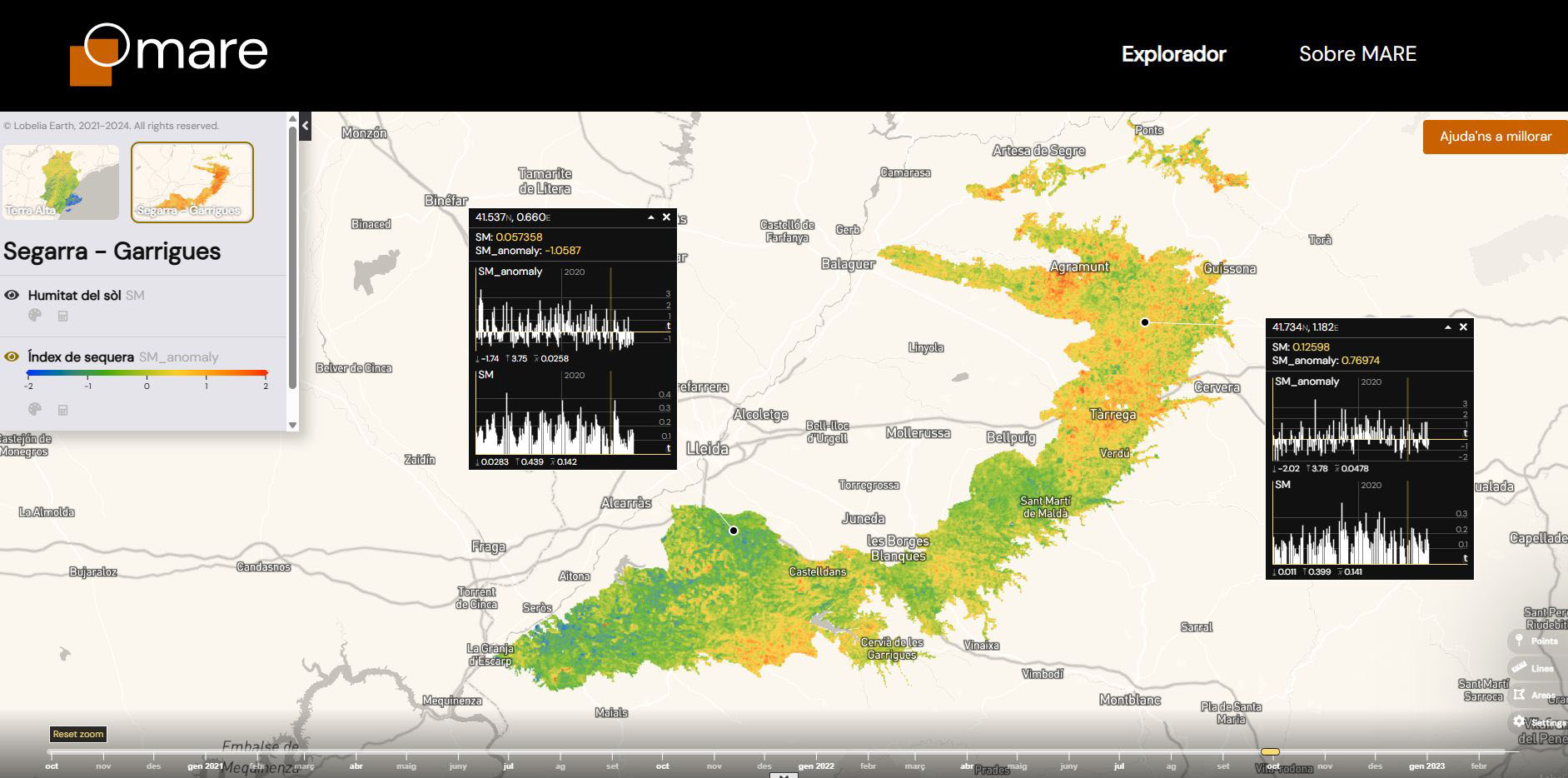
|
►MARE maps over the Terra Alta irrigation community. © isardSAT | 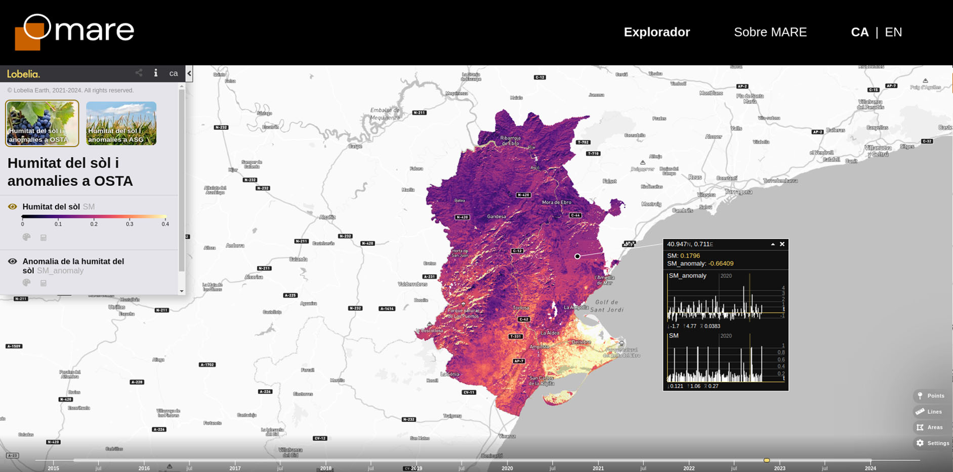
|
👉 MARE has also developed pilot soil moisture maps at 5 m resolution, demonstrating the ability to monitor soil moisture variability within individual parcels. These pilot maps combine data from SMAP, Landsat-8, Landsat-9, Sentinel-3, as well as Menut, opening a new perspective in the application of remote sensing for surface monitoring.
► Soil moisture map at a 5-meter resolution from Menut data over the Ebro Delta. © isardSAT. | 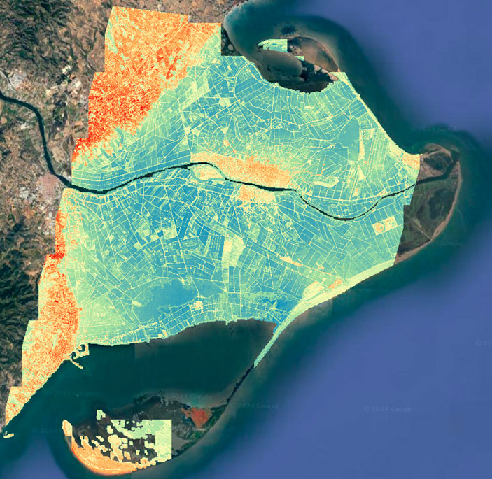 |
◀︎ A short video demonstration of the MARE platform. |
👉 More 'informations on the IEEC website
Related project(s)
Non SCO
SCO
- BOSCO, Soil Moisture Monitoring Demonstration Project in Brittany (France)