

RESPECT

REmote Sensing of Pressure Erosion on Costal ecosysTems from New Caledonia
Overview
The RESPECT project (REmote Sensing of Pressure Erosion on Costal ecosysTems from New Caledonia) is the first phase of a program designed to protect the lagoon from sedimentation from watersheds. It is based on the development of an integrated watershed management tool to share the best understanding of sediment creation from the ridges to the estuary, in order to fight more effectively against lagoon water turbidity, whether of natural or anthropogenic origin.
By combining satellite, meteorological and field data on soil erodibility in the watershed, this tool will be able to simulate the impact of climate change (rainfall levels, etc.), anthropogenic pressure (mining, fires, etc.) and biodiversity imbalances (overpopulation of deer, pigs, etc.) on soil erosion levels. It will thus help identify the most vulnerable areas (today and in 2100 via the CLIPSSA* forecasts) and guide local conservation actions, particularly in the pilot basins of Thio and Koniambo.
The aim will be to implement a parsimonious and free model with perennial data sources and parameters calibrated in situ. Field sampling will be complemented by machine learning to provide data sets at the scale of the watersheds studied.
Future users, including local authorities, provinces, communes and industrialists (particularly in the mining sector), will be involved in the project from the earliest stages, and will be able to fine-tune the tool to their operational needs as development progresses.
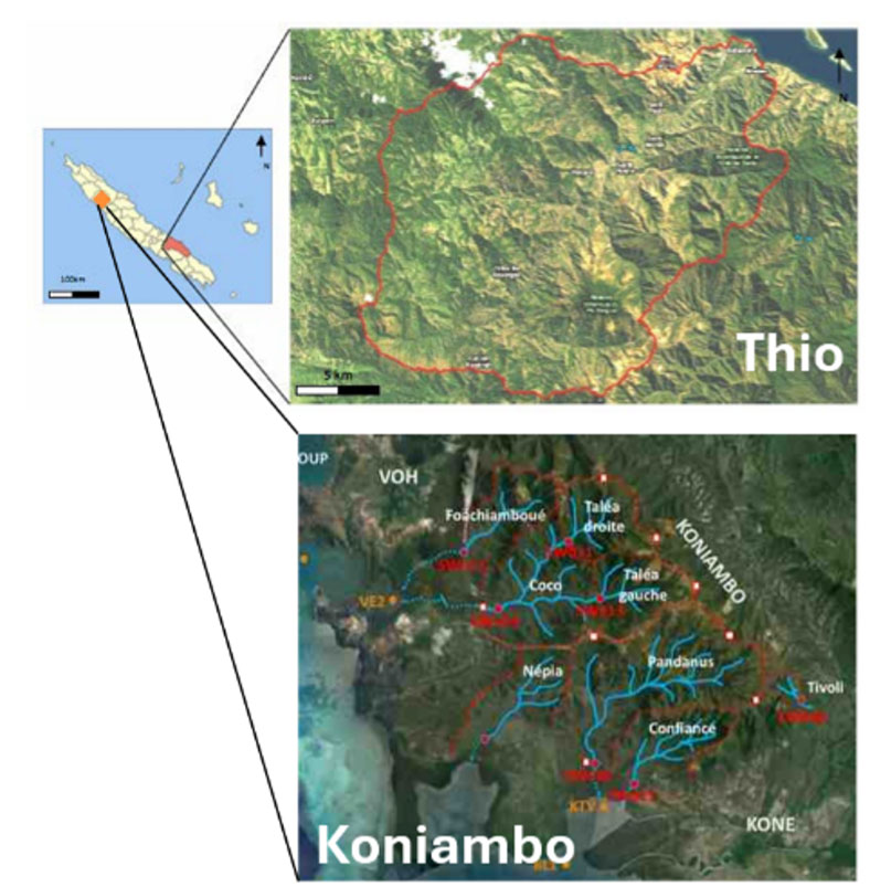
Application site(s)
|
New Caledonia
► The watersheds defined as priorities are in particular those of Thio and Koniambo (Voh-Koné-Pouembout zone) as they have data from previous projects and regulatory monitoring from the mines. @ CNRTEC |
|
Data
Satellite (to be confirmed in the project)
- Sentinel-2 (superspectral)
- Landsat8/9
- Pléiades
- Pléiades Néo (deep blue + rededge)
- CO3D (Digital Terrain Model)
- Copernicus C3S (ERA-5, forecasts)
Other
- Meteo France NC
- IAC/IRD soil bank
- Ad hoc acquisition of erodibility and spectral response data
Results – Final product(s)
The project consists in developing a new module in the QVX platform specifically for modeling, analyzing and predicting erosion in watersheds.
The products are cartographic analyses of erosion zones for a given site coupled with a given rainfall scenario; thus, calculating the sediment supply to the watershed estuary for this event.
Access to this module will be facilitated for members of CNRTEC (New Caledonia), and territorial and international marketing is planned.
References
-
M. Allenbach et coll. (2015) – Volume I - Rapport de Synthèse. Programme « Fonctionnement des petits bassins versants miniers ». CNRT « Nickel & son environnement ». 55 pages. FPBVM ET HYDROMINE | CNRT
-
Allenbach M. et coll. (2020) – Rapport scientifique. Programme « IMMILA, Impact de la mine au lagon ». CNRT « Nickel & son environnement ». 251 pages. IMMILA | CNRT
-
Juillot F. et coll. (2019) – Rapport scientifique final. Programme « Dynamique des métaux de la mine au lagon (hydrosphère et écosystèmes coralliens) ». CNRT « Nickel & son environnement ». 202 pages. DYNAMINE | CNRT
Related project(s)
- SCO TAHATAI, monitoring and governance of the littoral zone in the Pacific, which uses the QVX platform
- CLIPSSA (Climat du Pacifique, Savoirs Locaux et Stratégies d'Adaptation), which aims to develop new scientific data on the future climate of the South Pacific, to analyze sectoral impacts on agricultural systems and water resources, and to produce and transmit new knowledge in each territory.