

SCO FrichesAgricoles

Project completedFrom October 2022 to March 2024, Safer Occitania, in association with CNES and national federation of Safer companies (FN Safer), led SCO Friches Agricoles, an innovative project based on satellite imagery and Artificial Intelligence. This enabled automated pre-identification of agricultural wasteland and the creation of the first “2023 WaSaBi wasteland inventory” at the regional level, in Occitania (France).
👉 The tools and processes developed have enabled the inventory to be updated for the year 2024.
OVERVIEW
Territorial planning actors are faced with various challenges, including adaptation to climate change, improving food sovereignty, maintaining biodiversity and a healthy and safe living environment.
|
In Occitania, the development of agricultural wasteland is a major concern in a context where the risk of fire and health problems continue to increase. These risks strongly involve wasteland, which is the source of fire outbreaks and also a reservoir of diseases (e.g. flavescence dorée, vine disease) and parasites (e.g. Xylella fastidosia, a bacterial killer of olive trees). This is why knowledge of wastelands - their location and state of evolution - is essential to prevent and improve the effectiveness of emergency services and the protection of inhabited areas, to monitor and fight against the development of harmful organisms. |
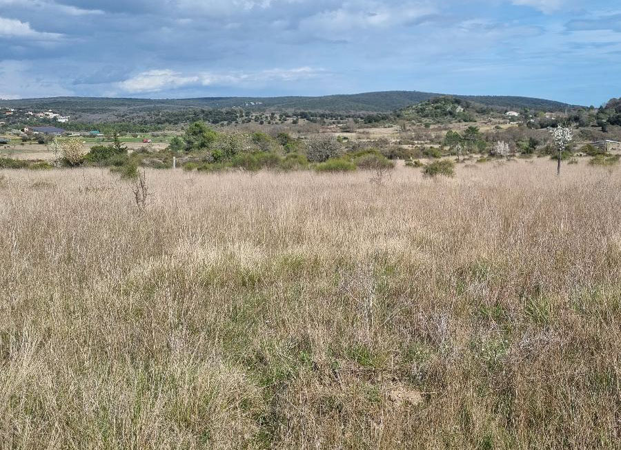
Low shrubby scrubland - Commune de Mèze in Hérault © Safer Occitanie |
The reclamation of wasteland land is also a lever for territorial revitalization and food sovereignty, the requalification of areas to preserve the environment, and carbon sequestration through adapted cultivation practices that preserve living soil.
However, the detection of agricultural wasteland is a complex issue, for which several inventory strategies have been successively carried out by a limited number of DDTs (departmental directorate for the territories) and by the Safer (land development and rural establishment company, Société d'aménagement foncier et d'établissement rural), with disparate results.
| This is why the SCO FrichesAgricoles project was launched, with 4 objectives: |
- Create an inventory method for automated identification of agricultural wasteland using WaSaBI ©CNES software, trained on the basis of field data from the Vigifriche mobile application.
- Produce a database of agricultural wastelands in Occitania
- Develop a web interface for consulting and querying data
- Enable tools and methods to be transposed to all regions of France.
Methodology
|
The SCO Friches Agricoles project has enabled us to improve and consolidate the methodological work on the WaSaBi software initiated in 2020 as part of a project run by the DDT82, CNES and Safer Occitania in the Tarn et Garonne department, to make it a reliable inventory and monitoring tool validated for the whole of Occitania. Safer Occitania, CNES Lab'OT and FN Safer, supported by INRAE, have produced an effective and reproducible method, based on the analysis of satellite images and geographical data by WaSaBI (Wasteland Satellite Bulk Identification) Artificial Intelligence software, developed by CNES with the support of Safer Occitania. |
Methodology overview. © Safer |
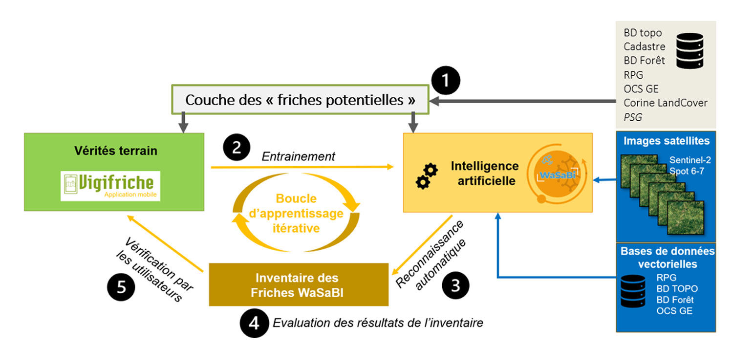
The methodology used to produce the WaSaBI wastelands inventory in Occitania is summarized below, in 5 steps:
- Step 1: Production of the "potential brownfields" layer
In line with the definition of agricultural wasteland1 adopted by the Occitania regional agricultural wasteland community (Communauté Régionale des Friches Agricoles d'Occitanie CRéFAO), only certain areas are subjected to Artificial Intelligence analysis in order to produce the "WaSaBI wasteland" inventory. For this reason, cartographic pre-processing is carried out to create the "potential wasteland" layer. To do this, various vector data are cross-referenced (RPG sources, OCS GE, BD Foret from IGN, Corinne Land Cover, etc.) in order to eliminate urban and forest areas, as well as agricultural plots on which an activity is declared (details in the diagram below). Further processing is carried out to exclude from the database all plots with a surface area of less than 500 m2.
1Agricultural wasteland is defined as an area or piece of land with no active human occupants, which is consequently not or no longer exploited, productive or even maintained. It is the result of agricultural abandonment of the land (absence of development, definitive abandonment or abandonment over a long period), unlike fallow land, which is merely a temporary period of rest for the soil.
- Step 2: Training WaSaBI©CNES with a "ground truth" database
The WaSaBI software is used to train an artificial intelligence model to recognize wasteland based on "ground truths" (wasteland and non-wasteland) identified using the Vigifriche mobile application. Once the model has been trained, the WaSaBI©CNES software is able to automatically recognize “WaSaBI wastelands” in new geographical areas.
To produce the 1st vintage of WaSaBI wastelands, some 5,000 plots of "ground truth wasteland" (2,500 ha) and 127,000 plots of "non-wasteland" (51,000 ha) were evaluated via 6 iterative learning loops. In 2025, these areas and the number of plots of “real land” (both wasteland and non- wasteland) had more than doubled for the completion of a 7th WaSaBI©CNES learning loop, enabling the production of the 2nd inventory.
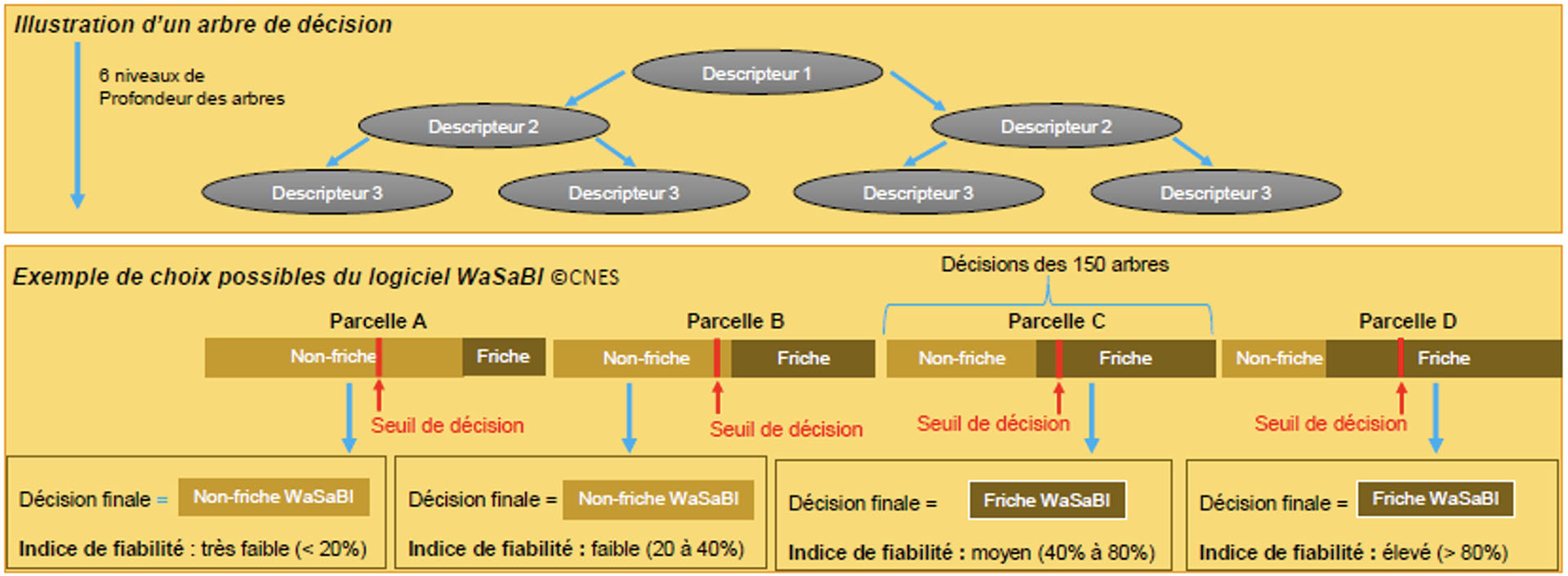
- Step 3: Automatic recognition of "WaSaBI wastelands"
The trained artificial intelligence model is made up of 150 decision trees using 96 descriptors to characterize each of the plots in the "potential wasteland land" layer. Based on the descriptor values (radiometric and texture indices, overlap areas, etc.), each of the decision trees makes a choice (wasteland or non-wasteland). The decision as to whether or not the plot belongs is determined by a "vote", which defines the plot as "WaSaBI wasteland" if the number of trees choosing " wasteland" exceeds a certain decision threshold. The result of this "vote" is called the reliability index (value between 0 and 100%). If the results of the various decision trees easily lead to a choice of "WaSaBI wasteland", the reliability index will be high (over 80%). On the other hand, if the choice is complex, the reliability index will be average. Below a certain decision threshold (≃ 30%), the software will classify the plot as "non-WaSaBI wasteland".
- Step 4: WaSaBI performance evaluation
During the training phase, the WaSaBI software calculates various indicators (recall, precision and fscore) that measure the model's ability to identify WaSaBI wasteland accurately and exhaustively. These indicators are calculated on a specific dataset that was not used for training (= validation base made up of 800 ha of ground-truth wastelands spread over some 50 communes for the first inventory and 1,636 ha for the second one). This analysis established a performance rate for the WaSaBI software of 65% for the first inventory (April 2024) and 73% for the second edition produced in October 2025.
This performance gain was achieved by updating satellite and vector data, conducting additional training on more numerous and varied “ground truth” data, and making various technical improvements thanks to Thales.
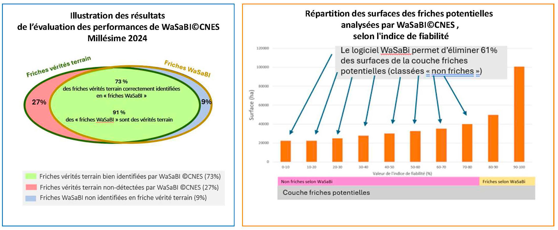
Left : Illustration of the results of the WaSaBI©CNES performance assessment for 2024. Right: Distribution of potential wastelands sites analyzed by WaSaBI©CNE, according to reliability index (the WaSaBI software eliminates 61% of potential wastelands sites (classified as “non- wastelands ”).
- Step 5: WaSaBI wasteland verification
As wasteland is a complex element that changes over time, it's a good idea to check out "WaSaBI wasteland" in the field, before moving on to the operational phase of a project. This step, carried out via the Izifriche®mobile app, allows you to specify the type of wasteland (9 categories available) or, if necessary, to change its classification if it has been recultivated (land, meadow, vineyard...).
By contributing to the “ground truths” database, these verifications help train the WaSaBI©CNES software, helping to improve results over time.
Application site(s)
The Occitania region, in particular :
- Commune of L’Honor de Cos - Tarn et Garonne
- Commune of Nyls Ponteilla - Pyrénées Orientales
- Commune of Figeac - Lot
- Commune of Moissac - Tarn et Garonne
DATA
Satellites
- Sentinel-2 de niveau 3A
- SPOT6/7
Other
- IGN databases BD TOPO, BD Forêt, OCS-GE and RPG available in OpenData
- Cadastral repository available in OpenData
RESULTS - FINAL PRODUCTS
The results are as follows:
Building an effective method and operational tools
👉 Allows automated pre-identification of agricultural wasteland on a regional scale, with a performance rate of around 73%.
Creation of the 1st WaSaBI inventory of agricultural wasteland (April 2024) and its update (October 2025) for the Occitania region
👉 The results demonstrate the benefits of using artificial intelligence and satellite imagery, compared with a method based solely on field surveys or vector data cross-referencing (speed of processing and "cleaning" of the vector layer).
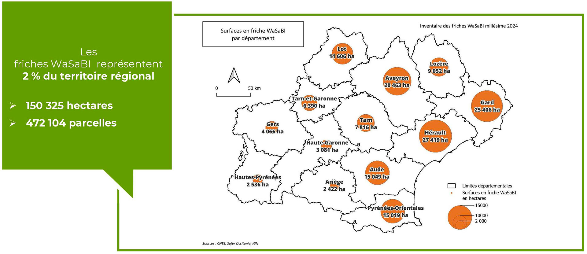
▲ WaSaBi wasteland accounts for 2% of the region's territory
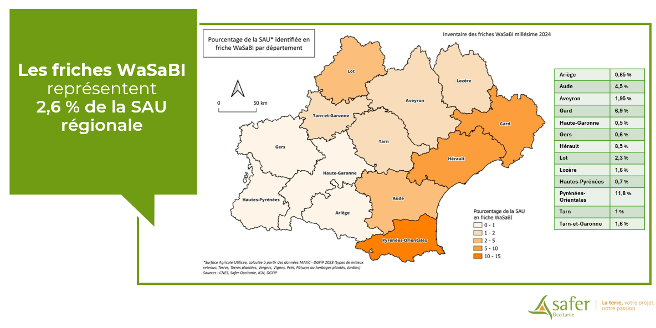
▲ WaSaBi wasteland accounts for 2,6% of the regional UAA (utilized agricultural area)
Consolidation of tools and processes
👉 Produce inventory updates that facilitate monitoring while limiting associated costs.
👉 Extend the methodology and inventory work to other territories to increase the diversity of training sources for the WaSaBI©CNES software and make it even more powerful.
Creating of Izifriche® for data access and visualization of wastelands
|
|
The Izifriche® solution provides access to data and tools for identifying, classifying, and maintaining the automated pre-identification of agricultural wasteland produced by WaSaBI©CNES. |

|
This innovative tool for data collection and analysis is based on three complementary tools: 🛰 The inventory of “WaSaBI wastelands,” 📲 The mobile app for verifying wastelands in the field, 💻 The web interface for viewing, exporting, and contextualizing wastelands data. |
|
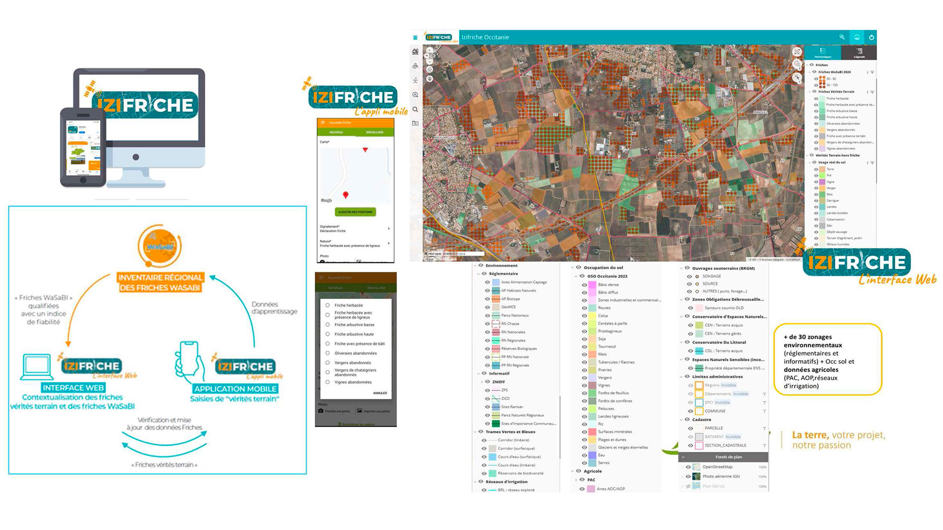
The web interface provides users with information on agricultural, environmental, and forestry issues in their project area:
- Viewing and exporting WaSaBI wastelands sites and actual wastelands sites,
- Viewing the WaSaBI wastelands data reliability index.
- Access to reference databases, environmental and agricultural zoning,
- Access to cadastral data (for rights holders),
- Automatic requests for “wastelands” summary sheets at the parcel, municipality, and department levels,
- Viewing and exporting of “areas with silvopastoral potential” data.
More than just a technological solution, Izifriche® is an operational lever to help local actors launch actions for the revitalization of their territory, for food sovereignty, and for the preservation of the environment.
OUTLOOK
The work undertaken with CNES as part of the SCO has made it possible to consolidate a method and lay the foundations for tools that will be maintained and deployed by Safer Occitania.
The operation is due to be extended nationwide, in successive stages, thanks to the mobilization of the National Safer Federation (Fédération Nationale des Safer), which will support other regional Safer companies in the production of their inventories:
- First phase of experimentation and consolidation in several new territories complementary to the initial project (project in Auvergne-Rhône-Alpes, Centre, Nouvelle-Aquitaine, Provence-Alpes-Côte d'Azur), end of 20258-2026.
- Second phase of national inventory production, based on the results of the extended trial (2027).
- Third phase of industrialization of the process to guarantee annual renewal of national data.
To achieve each of the post-SCO development stages, we need to forge partnerships both within the Safer group (FN Safer and regional Safer) and with institutional structures that can provide financial and/or technical support. An agreement with one or more technical service providers is currently under consideration.
References
| SCO FrichesAgricoles on GEO Knowledge Hub, a long lasting digital repository created by the Group on Earth Observations: https://doi.org/10.60566/hv421-ze780 |
PROJECT NEWS
-
20/11/2025: Presentation of the SCO approach and Izifriche® at the 2025 Paris Mayors' Fair, on the topic of “The transferability of satellite applications to facilitate the use of solutions developed from satellite data by various public bodies.”
-
13/11/2025: Izifriche®: the 2024 inventory of agricultural wastelands in Occitania is now available
-
14/10/2025: Webinar by the Occitanie Regional Community of Agricultural Brownfields on the theme of “Agricultural wastelands in Occitania: inventory, health issues, and courses of action for more robust territories.” Presentation of the results of the SCO Friches Agricoles and presentation of the 2nd vintage of Occitanie's agricultural brownfields.
-
17/04/2025: Presentation of SCOFrichesAgricoles and Izifriche® at the conference organized by the University of Spirits in Segonzac on the theme of “Wine-growing applications of artificial intelligence.”
-
17/3/2025: Presentation of the SCOFrichesAgricoles and the creation of Izifriche® at the DREAL Pays de Loire.
-
26/04/2024: Webinar of the Occitania regional agricultural wasteland community (Communauté Régionale des Friches Agricoles d'Occitanie) with the presentation of the results of the SCO Friches Agricoles and launch of Izifriche, a service for local players, giving access to tools (mobile application, web interface, WaSaBI inventory of wasteland), by jurisdiction.
-
05/04/2024: Agricultural wasteland, discover the Izifriche solution
-
21/12/202 : Présentation du projet SCOFrichesAgricoles et de ses avancées lors de la 11ème Trimestrielle du SCO France « Des services innovants pour des pratiques agricoles résilientes »