

SCOFrance
450Wetlands monitored over time
PartnersTour de Valat, laboratoire ICube, société Geomatys, CNES, OFB
Useful linkAIonWetlands project page
Key wordsMediterranean wetlands, remote sensing, spatial monitoring, conservation, restoration
AIonWetlands on the home straight

50% of natural Mediterranean wetlands have been lost since 1970. Yet these ecosystems, among the richest and most productive, are vital to the survival of humanity.
|
In the heart of the Camargue (France), the private research institute La Tour du Valat is entirely dedicated to wetlands, conducting research programmes on their functioning and testing management methods adapted to their specific challenges and characteristics. The Tour du Valat, which also runs the Mediterranean Wetlands Observatory MWO (Observatoire des Zones Humides Méditerranéennes OZHM), has been awarded the SCO label for its AIonWetlands project, the aim of which is to use satellite data to automate large-scale monitoring of Mediterranean wetlands in 28 countries, including new indicators. Strongly supported by the SCO, the project is funded by the CNES and the French Biodiversity Office OFB (Office Français de la Biodiversité). |
"Habitat and land-use maps are essential for analysing trends in wetlands which, in addition to climate change, are subject to anthropogenic pressures from agricultural and urban development. With AIonWetlands, we are going to automate the existing monitoring of 310 MWO sites and balance this sampling with predictive maps on almost 150 new sites on the northern shore of the Mediterranean, where there is no in situ monitoring. The data, which will be freely accessible, will be useful to institutional decision-makers, civil society players and scientists to help preserve and restore these areas, as well as raising public awareness of the cause of wetlands. Anis Guelmami, project leader for the Tour du Valat. |
Progress report
- Satellite data processing
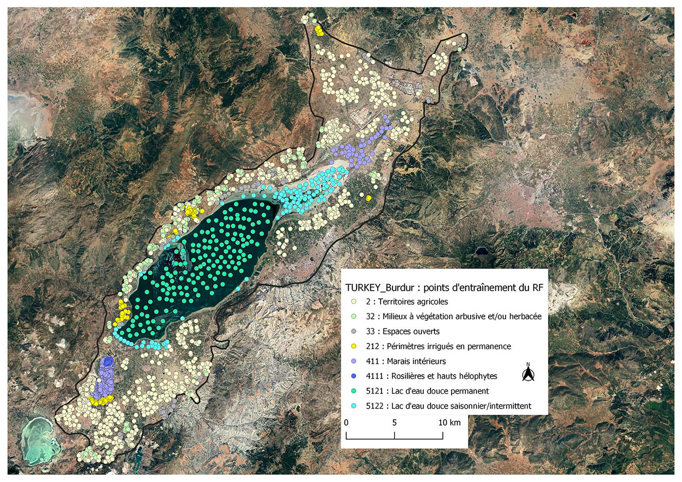
After carrying out a number of tests, the project team decided to opt for automatic learning using the Random Forest algorithm, based on Sentinel-2 satellite images and Landsat TM and ETM archives retrieved via Google Earth Engine. "For the time being, Random Forest is learning from training data and checking its classification against a validation set. This involves either existing data from our MWO partners, or very high-definition images interpreted using the expertise of the Tour du Valat. Eventually, we will organize field campaigns on a selection of sampled sites from the 400 monitored, in order to validate the methodological approach as a whole," explains Nina Bègue, a remote sensing engineer at Tour du Valat who is in charge of this algorithmic implementation.
 |
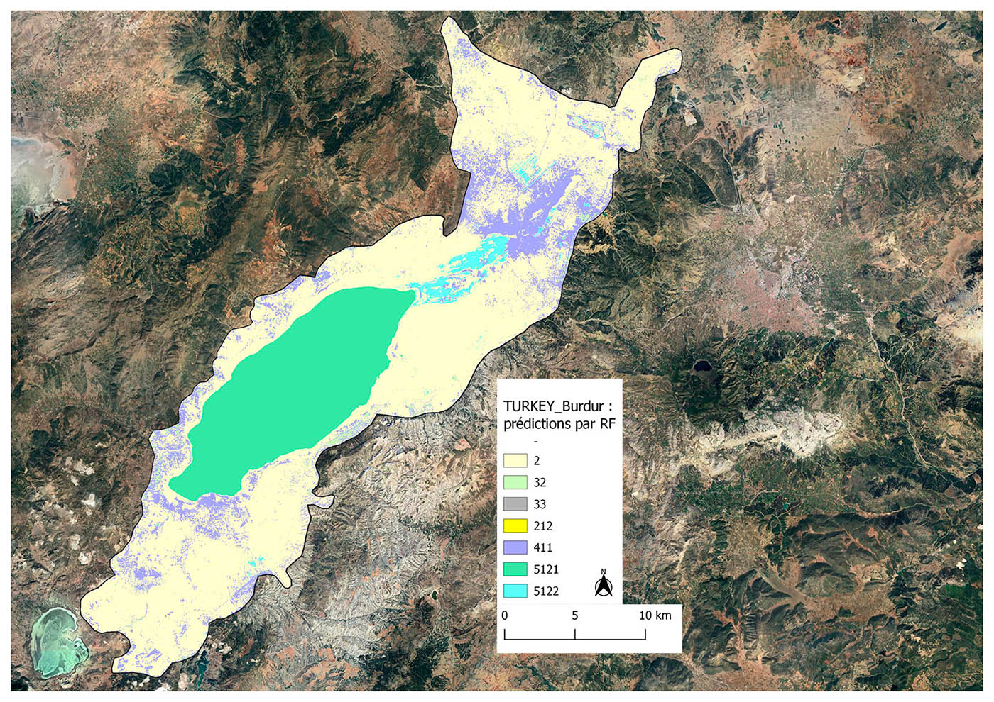 |
Lake Burdur in Turkey is the very first training site for automatic data processing. On the left, the points identified to characterize the land use classes (wetland habitats, agriculture, vegetation, etc.) that will drive the Random Forest. On the right, the map produced by the algorithm. © Google Satellite background map/Processing by Nina Bègue-Tour du Valat
The processing chain is now almost operational, and the team will be launching the production of maps and indicators in the coming weeks. These maps will show changes from 1990 to 2020, a long time needed for the indicators to be reliable and provide sufficient information.
- Implementation of the geoportal
Developed in parallel with the processing chain, the structure of the data distribution geoportal is well defined. According to Dorian Ginane, developer at Geomatys, "from the tree structure of indicators to the various data display modes, the core functionality is ready. We're now focusing on creating an ergonomic and practical design that will be accessible to as many people as possible", as the portal will be freely accessible and used by all MWO partners.
The home stretch
The project team is currently in the process of producing the data and expects to finalize the integration of the data and put the geoportal online by the end of 2024. In its sights, the MWO intends to present these key results of the AIonWetlands project at the next Ramsar COP-15 (International Convention on Wetlands), scheduled for July 2025 in Zimbabwe, notably as part of a side-event specially dedicated to monitoring Mediterranean wetlands.
Want to see more?
We're only revealing a tiny part of the work and information involved in this magnificent project! And why is that? Because it's the project team itself that talks about it best, which it did at the 13th SCO France Quarterly meeting, on 20 June 2024, on the theme of "Water and coastal quality".