

AIonWetlands
.")
Earth Observation for Mapping and Monitoring Mediterranean Wetlands
Overview
The Mediterranean Basin is a global biodiversity hotspot, thanks in particular to the presence of a large diversity of wetlands, considered to be the richest and most productive ecosystems in the region. However, despite their importance for humans and nature, these environments are also the most threatened by human activities: according to a study carried out in 2018 by the Mediterranean Wetlands Observatory (MWO), it is estimated that almost half of the natural wetland habitats within this region have disappeared since the 1970s.
One of the main causes of this rapid decline would be their direct loss, with conversion to other forms of land use. Indeed, according to the same MWO study, 47% of natural wetland habitats have been lost through conversion to artificial wetlands (e.g. dams/reservoirs, aquaculture ponds...), 46% to cultivation, 5% to built-up land and the rest swallowed up by the sea (i.e. a little over 2%).
Faced with this alarming situation, it is therefore crucial to gather as much relevant information as possible on the state of Mediterranean wetlands and to analyse the trends of their natural habitats as well as the main threats to them. To this end, the MWO has been developing, since 2012, an Earth Observation-based monitoring programme, allowing the extraction of a number of status andpressure indicators from thematic maps derived from Landsat and Sentinel-2 time series and covering different annual periods between 1975 and 2020 (example in Figure 1). The current sample of sites monitored by the MWO includes more than 320 wetlands, spread over all Mediterranean countries. However, this sample, although important, is not representative of all Mediterranean wetlands and of the main pressures and threats they face. In addition, many important Mediterranean wetlands for biodiversity (including some classified as Ramsar sites) are not included in this sample. If these were to be added to the current monitoring, the total number of sites monitored by the MWO could be doubled and the coverage of Mediterranean wetlands important for biodiversity could be greatly improved (Figure 2).
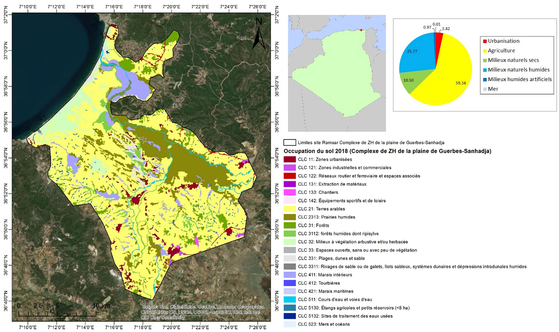
Figure 1: Example of a land use map produced for one of the sites monitored by the MWO (Guerbes-Sanhadja Wetland Complex in Algeria), as well as the spatial indicators extracted from it (pie chart with figures in %). © MWO
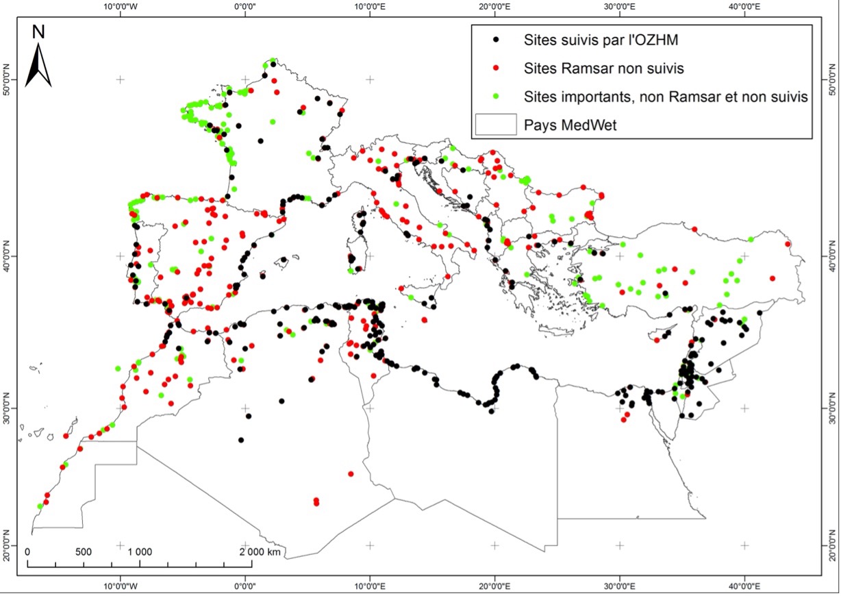
Figure 2: Mediterranean sites already monitored by the MWO (black dots) and those proposed for expansion of this sampling (red and green dots). © MWO
The objective of this project is therefore to better characterise the status and trends of the most important Mediterranean wetlands for biodiversity, including those not currently systematically monitored by the MWO. By coupling time series of satellite images with other existing databases relevant to the monitoring of these ecosystems, a set of standardised indicators will make it possible to identify the areas that are most threatened and/or most vulnerable to certain risks linked to global change. This project will ultimately provide local and national authorities with a simple, interactive and innovative decision-making tool to better prioritise future conservation and/or restoration actions for Mediterranean wetlands.
Application site(s)
Mediterranean basin: Portugal, Spain, Andorra, France, Monaco, Italy, Vatican, San Marino, Malta, Slovenia, Croatia, Serbia, Kosovo, Bosnia-Herzegovina, Montenegro, Albania, Greece, Bulgaria, Turkey, Cyprus, Syria, Lebanon, Jordan, Palestine, Israel, Egypt, Libya, Tunisia, Algeria and Morocco.
Data
Satellite
- Landsat TM (Thematic Mapper) et ETM (Enhanced Thematic Mapper Plus)
- Sentinel-2
Other
- Copernicus DEM 30
- Gridded Population of the World (GPW)
- World Database on Protected Areas
Results – Final products
1) Thematic maps (land use and surface water dynamics
2) Indicators for monitoring Mediterranean wetlands:
Status indicators
- Total extent of natural and artificial wetland habitats in 1990 and 2020
- Area of cultivated land in 1990 and 2020
- Area of built-up areas in 1990 and 2020
Trend indicators
- Change in the total extent of natural and artificial wetland habitats between 1990 and 2020
- Change in the area of cultivated land between 1990 and 2020
- Evolution of the surface area of built-up areas between 1990 and 2020
- Conversion rate of natural wetland habitats to artificial wetland habitats
- Rate of conversion of wetland habitats to agricultural land
- Conversion rate of wetland habitats to built-up areas
- Rate of conversion of agricultural land to built-up areas
3) Interactive and evolving geoportal, integrating all the maps and indicators produced.
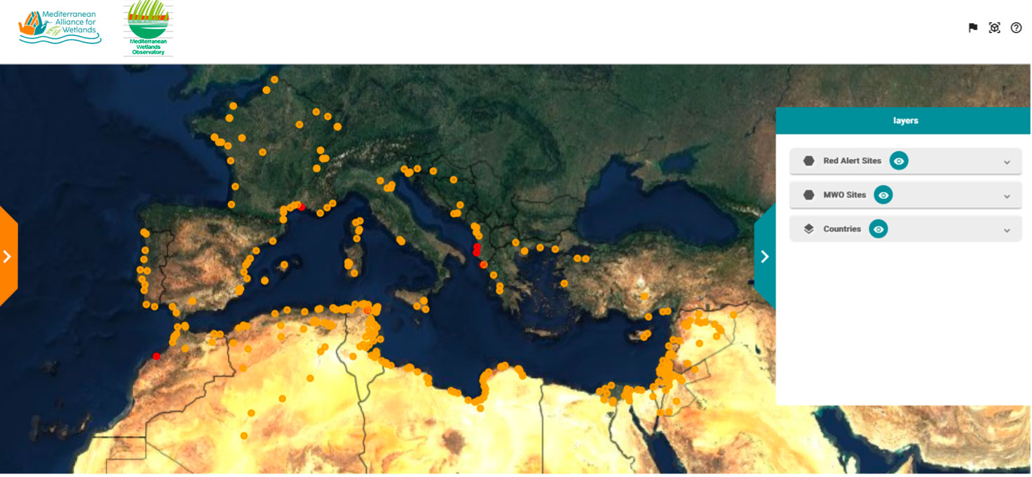
Figure 3: Overview of the interactive visualisation interface. © MWO
References
| AIonWetlands on GEO Knowledge Hub, a long lasting digital repository created by the Group on Earth Observations: https://doi.org/10.60566/ed156-dvn87 |
- Mediterranean Wetland Observatory (2014). Land cover: Spatial dynamics in Mediterranean coastal wetlands from 1975 to 2005.Thematic collection 2. Tour du Valat, France
- Mediterranean Wetlands Observatory (2018). Mediterranean Wetlands Outlook 2: solutions for sustainable Mediterranean wetlands. Tour du Valat, France.
- Obrenović M., Lampert T., Monde-Kossi F., Ivanović M. and Gançarski P. (2021). SS-HIDA: Semi-Supervised Heterogeneous Image Domain Adaptation. MACLEAN: MAChine Learning for EArth ObservatioN Workshop co-located with ECML/PKDD, Virtual, September.
- Parusinski M., Ibrahim S., Lampert T. (2022). Study On Generalizing Building Extraction Models To Unseen Datasets Using Source Adaptation. Submitted to IGARSS 2022.
- Perennou C., Guelmami A., Paganini M., Philipson P., Poulin B., Strauch A., Tottrup C., Truckenbrodt J., Geijzendorffer I., (2018) Mapping Mediterranean wetlands with remote sensing: a good-looking map is not always a good map. Advances in Ecological Research 58:243–277.
- Popoff N., Gaget E., Béchet A., Dami L., Defos du Rau P., Geijzendorffer I., Guelmami A. et al. (2021). Gap analysis of the Ramsar site network at 50: over 150 important Mediterranean sites for wintering waterbirds omitted. Biodiversity and Conservation. Read
- Weise K., Höfer R., Franke J., Guelmami A., Simonson W., Muro J., O’Connor B., Strauch A., Flink S., Eberle J., Mino E., Thulin S., Philipson P., van Valkengoed E., Truckenbrodt J., Zander F., Sanchez A., Schröder C., Thonfeld F., Fitoka E., Scott E., Ling M., Schwarz M., Kunz I., Thürmer G., Plasmeijer A., Hilarides L. (2020). Wetland extent tools for SDG 6.6.1 reporting from the Satellite- based Wetland Observation Service (SWOS). Remote Sens. Environ. 247, 111892. Read
Project news
- 26/06/2024: Presentation of the AIonWetlands project and its progress at the 13th SCO France Quarterly Meeting "Water and coastal quality"
- 21/05/2024: AIonWetlands on the home straight
- 16/05/2023: AIonWetlands trains its algorithm