

BOSCO

Space Observatory of Soil Water Content in Brittany
Project completedThe Brittany region now has a tool for monitoring soil moisture in Brittany via the freely accessible BOSCO platform. By laying the foundations for knowledge over the period 2017-2022, the tool strengthens regional data on soil water content estimates for a better assessment of the benefits of public policies in terms of water resource management, nitrate pollution and hazard management (drought, agricultural disasters, flooding, landslides).
OVERVIEW
Water is an essential resource for humans and ecosystems: temporarily stored in the subsurface, it is consumed by vegetation and flows to rivers through hillslopes. In Brittany, 75% of water resources are exploited from surface water, supported by a set of small groundwater systems in the altered part of crystalline rocks. The lengthening of periods without precipitation induces agricultural and hydrological droughts (including in winter), threatening water supply systems, agricultural management schemes and efforts to restore the good ecological status of aquatic ecosystems (Figure 1). This climatic transition began in the 2000s and requires the adaptation of management tools, which must be based on dynamic observations of soil water content on a relevant scale, in addition to other meteorological and environmental architecture information. Until now, management tools have been based either on point or integrative observations (by "water mass"), or on models such as the SURFEX hydrometeorological model designed by Météo-France. However, its spatial resolution (64 km²) does not meet the needs of managers, particularly at plot scale (Figure 2).
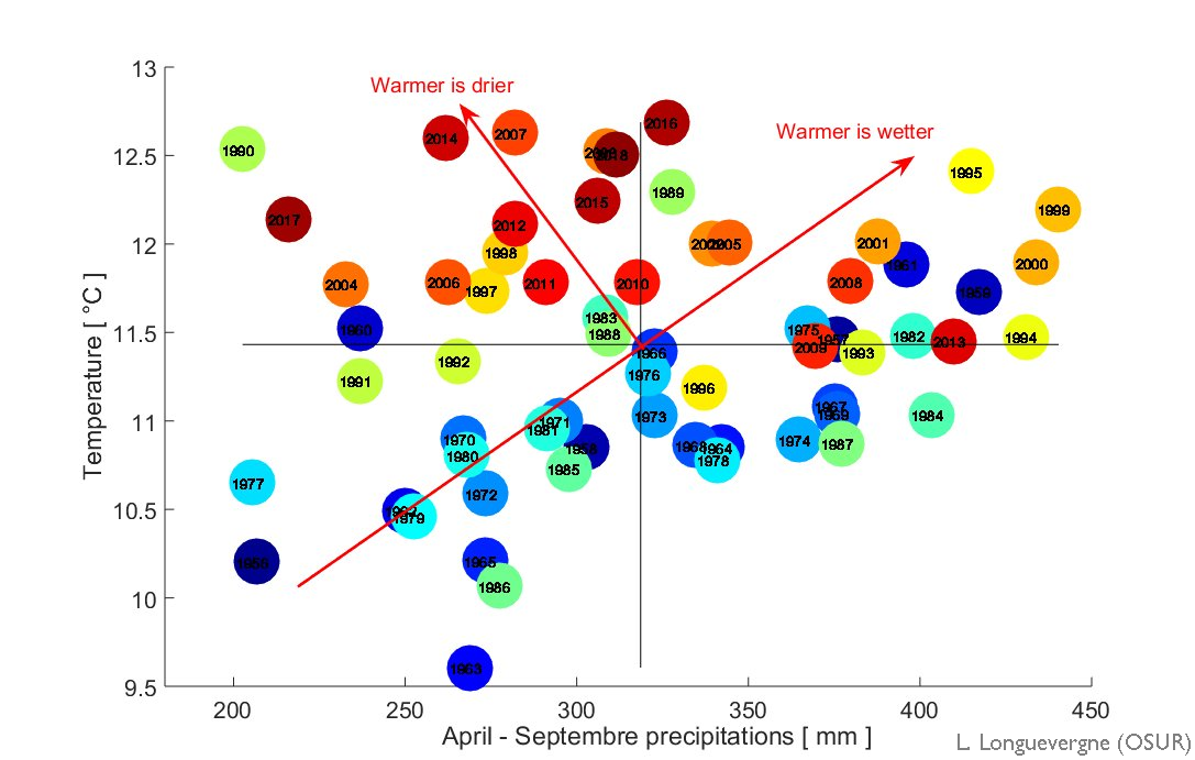
Figure 1: Changes in temperatures and summer precipitation at 12 stations in Brittany since 1955. The temperature increases by 3.5°C per 100 years. The impact of climate change on summer precipitation is reflected in 2 precipitation regimes: from the 1960s to 2000, hot temperatures were associated with higher precipitation, but since the 2000s, hot years are water deficient. © Geosciences Rennes
The BOSCO project consists in:
- Deploying a validated satellite product (THEIA's very high spatial resolution moisture CES) for monitoring soil water content in the Brittany region with open access;
- proposing relevant indicators at local and regional scales and derived products to define water availability and thus meet the needs of agriculture, resource management and ecosystem monitoring;
- developing a platform for dissemination and integrated visualization (regional Copernicus approach GéoBretagne) to train and support stakeholders in the appropriation of products. Thus, these homogeneous and accessible data will allow to standardize the analyses, to ensure their transparency and to support the territories in their new competences (e.g. GEMAPI).
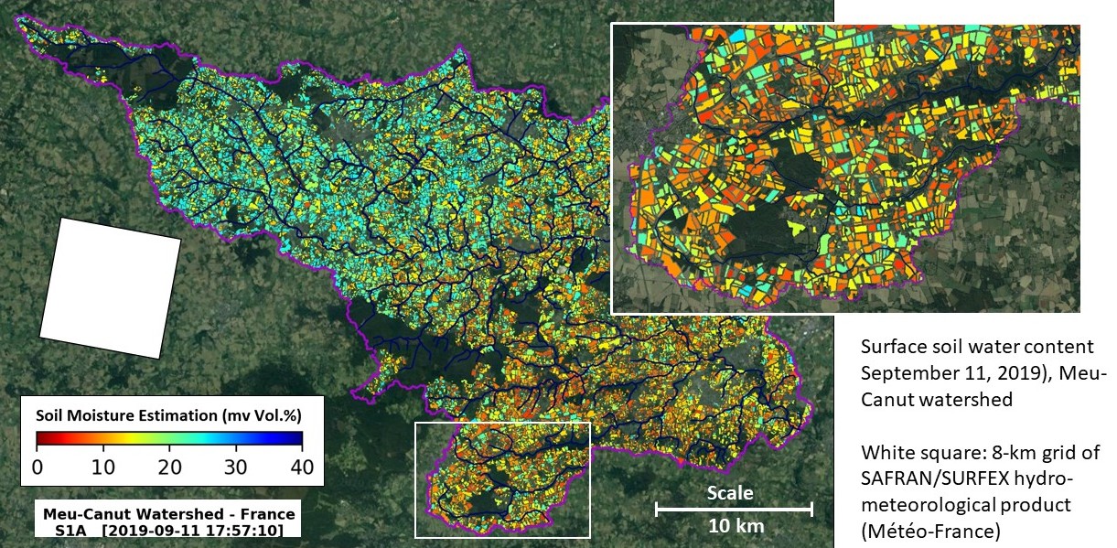
Figure 2: Parcel-scale distribution of water content in the Meu-Canut basin, west of Rennes, estimated by the CES THEIA product "Water content at very high spatial resolution". The white square corresponds to the SAFRAN/SURFEX analysis and modeling grid for estimating meteorological forcing and soil water content (Soil Water Index). Note the need for high spatial resolution to understand the specific high spatial variability in the behavior of hydrological systems. © Geosciences/CES THEIA
Consortium
Developed by the CNRS, INRAE and the Institut Agro Rennes-Angers, the tool was co-designed with end users responsible for risk management and the implementation of public policies relating to agriculture, resource management and ecosystem protection (DREAL, Météo France, Eau du bassin rennais, Chamber of Agriculture).The project also relied on "facilitators", i.e. expertise centers that actively participate in the use and development of satellite data (GIS BRETEL), the dissemination of data through accessible tools (GéoBretagne) and the development of environmental data in the territories (GIP OEB, Observatory of the Environment in Brittany). The Brittany region offers a very favorable context, as it is very involved in the development of spatial monitoring tools, and invested in the development of a regional policy for climate change mitigation. The project is part of the CNES-Region Bretagne framework agreement and will contribute to the development of the IRISPACE institute (Regional Institute for Space Innovation) which will start in 2021.
Application site(s)
Brittany region, France
DATA
Satellite
- Sentinel- radar
- Sentinel-2 multispectral
Others
- DREAL : General Land Register Data and River flow
- METEO-France : Precipitation, evapotranspiration
- Ground observations: water content, geophysical data, recharge estimates
Methodology
To estimate the water content at very high spatial and temporal resolution at the scale of Brittany, the BOSCO algorithm relies mainly on the constellation of satellites from the European Copernicus program. It combines Sentinel-1 (radar, moisture sensitive) and Sentinel-2 (optical/NDVI, vegetation status) data within a neural network to estimate soil water content over a thickness of ~5 cm with an accuracy of ~5% by volume. The estimator is based on realizations of a physical model, calibrated on 10 years of data collected in different climatic and soil contexts. The approach is not sensitive to cloud cover. The singularity of this product remains its spatial resolution, one parcel, relevant for agricultural and water resources management issues, and its temporal scale (2 days), relevant for understanding water flows. The estimation of water content in the root zone and of recharge requires meteorological forcing (SAFRAN/SURFEX analysis) which will be provided by Météo France, information on soil type (GéoBretagne) and river flow data for calibration (DREAL).
The validation of satellite products and derivatives relies on a set of "ground" environmental observatories, gathered in an observation platform supported by INRAE and CNRS laboratories (UMS OSUR and UMS IUEM), and associated with the research infrastructures OZCAR and RZA. The tools and data for measuring soil water content (by drone, continuous monitoring), local information (pedology, ...) and expertise on the functioning of the observed systems will be made available for satellite date validation on a fine scale. Météo-France will also provide the outputs of the SURFEX model and in particular the SWI soil moisture index for the validation of raw and derived products on a large scale.
Finally, to visualise changes in surface soil moisture, the aim was to apply the operational method for estimating and mapping soil moisture in the Brittany region developed at INRAE (UMR TETIS). This method is based on the use of satellite images from the new Copernicus radar and optical Earth observation systems Sentinel-1 and Sentinel-2 (free and open access data). These new sensors, which provide data with high spatial and temporal resolutions, have opened up new opportunities for mapping soil moisture in agricultural environments. Moisture estimates correspond to the moisture content of the top layer of soil (5-10 cm). Moisture maps are produced at the plot level for the years 2017, 2018, 2019, 2020 and 2021 (on agricultural plots and grasslands, excluding vineyards and fruit trees). In addition, NDVI index maps (spatialised information on the state of vegetation development) are calculated from Sentinel-2 optical images.
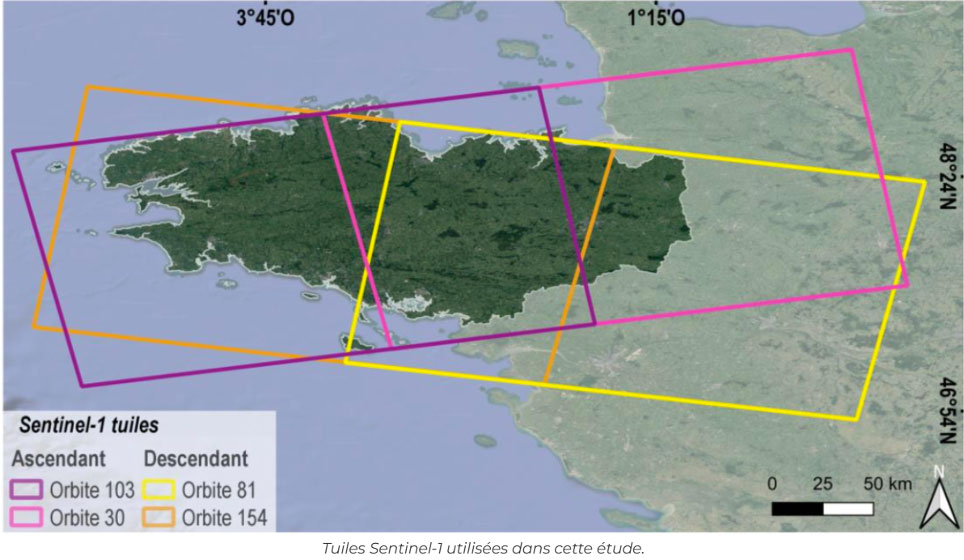
▲ Sentinel-1 tiles used in this study.
Soil moisture mapping
Spatial and temporal monitoring of soil moisture in agricultural areas is of great importance for many applications, particularly those related to the continental water cycle. The use of in situ sensors ensures this monitoring, but this technique is very costly and can only be carried out on a very small agricultural area, hence the importance of spatial remote sensing, which now enables large-scale operational mapping of soil moisture with high spatial and temporal resolution.
Radar images have long been used to estimate and map surface moisture in bare soil. For areas with vegetation cover, combining radar and optical data is often necessary to estimate soil moisture. Optical data complement radar data, and their value lies in their potential to estimate biophysical parameters of vegetation, such as the Leaf Area Index (LAI) and the Normalized Difference Vegetation Index (NDVI). These parameters make it possible to evaluate the contribution of vegetation to the backscattered radar signal, and consequently to extract the contribution of the soil, which can then be inverted to estimate soil moisture.
To map soil moisture in the case of vegetation-covered soil, most studies use the semi-empirical Water Cloud model developed by Attema and Ulaby in 1978. Generally, in this model, the total backscattered radar signal is modelled as the sum of the backscattered signal from the soil multiplied by bidirectional attenuation, and the direct signal reflected by the vegetation. In most studies, the contribution of vegetation is expressed by a biophysical parameter of the vegetation (biomass, LAI, vegetation water content, or NDVI). The contribution of the ground is generally modelled as a function of ground moisture and roughness for given instrumental parameters: angle of incidence, wavelength and polarization. It can be simulated using a physical radar backscatter model (Integral Equation Model "IEM" developed by Fung in 1994) or a semi-empirical backscatter model (e.g. the Baghdadi model, Baghdadi et al., 2016).
Recently, the arrival of the Sentinel-1 (S1) synthetic aperture radar (SAR) satellite has provided users with freely accessible SAR data at high spatial resolution (10 m x 10 m) and with a high revisit time (six days in Europe). The European Space Agency (ESA) S1 mission is a constellation of two polar-orbiting SAR satellites (Sentinel-1A and Sentinel-1B) operating in the C-band (~5.4 GHz). The high spatial and temporal resolution SAR data from the S1 mission has encouraged the operational mapping of soil moisture.
El Hajj et al. (2017) developed an operational method for mapping surface soil moisture (SSM) at the plot scale in agricultural areas based on the coupling of S1-SAR data and Sentinel-2 (S2) optical data using the neural network technique (S²MP). S2MP maps are produced for summer-winter crops in agricultural areas and grasslands (they are not produced for vineyards and orchards). S2MP maps are derived from S1 images acquired in ascending (acquisition time ~ 18:00 UTC) and descending (acquisition time ~ 06:00 UTC) acquisition modes. Nearly 20 S1 images cover most of France's watersheds completely or partially each month. This means that soil moisture estimates can be available every 3 or 4 days at most. The final moisture product has been validated through a large field campaign near the city of Montpellier (nearly 500 in situ measurements) and the accuracy obtained for volumetric moisture is in the order of 6 vol.%. The algorithm is generally applied as long as the NDVI vegetation index of the plots is not greater than approximately 0.7. Above this threshold, the radar signal does not reach the ground and it is impossible to estimate soil moisture because the received radar signal contains the contribution of vegetation but not that of the soil. In addition, the algorithm is applied to plots with a slope of less than or equal to 20%.
👉 See Nicolas BAGHDADI's report "Estimation of soil moisture and NDVI vegetation index on agricultural plots in Brittany using Copernicus satellite data" INRAe (in French)
RESULTS - FINAL PRODUCTS
Thanks to close collaboration between scientists and field workers, BOSCO has made it possible to:
-
Develop a product measuring surface soil water content at plot resolution (management unit) across the whole of Brittany.
👉 This consistent, open dataset facilitates dialogue between the various stakeholders to understand the quantities of water available and how they are shared. -
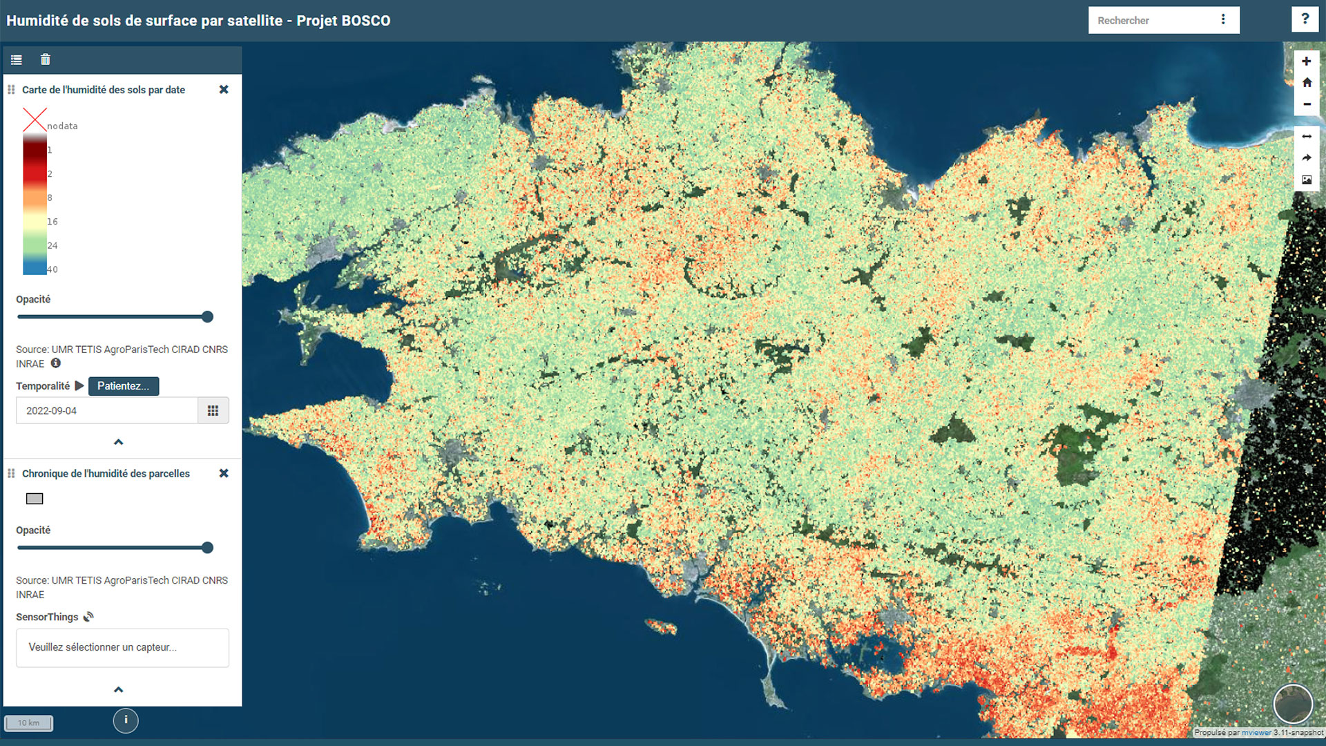
Implement the BOSCO platform for exploring this data, both spatially and temporally.
👉 The simple temporal synthesis tool, based on "seasonal norms", complements the visualization tools by offering forecasting tools. From a technical point of view, it is also the first coupling of two OGC standards for spatial and temporal data management (WMS + SensorThings). -
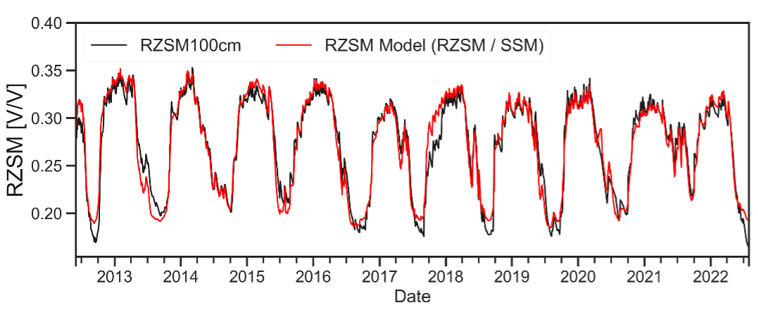
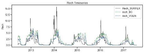
The development of a simple physical model that converts surface water content into both root water content (application: agriculture, agricultural disasters, ecosystem protection) and recharge (application: water supply and ecosystem protection).
-
The development of indicators useful for operational management at the plot level.
|
|
◀︎ Spatio-temporal exploration interface for water content data on the BOSCO interface. |
|
|
◀︎ Water content in root thickness. In black, in-situ observations; in red, estimates based on surface water content data using the simple model developed in BOSCO. |
|
|
◀︎ Recharge of the aquifer. In black, the Météo-France SURFEX model, considered a benchmark; in blue and green, two estimates based on surface water content data using the simple model developed in BOSCO. |
References
| BOSCO on GEO Knowledge Hub, a long lasting digital repository created by the Group on Earth Observations: https://doi.org/10.60566/gjf1h-3a910 |
-
Baghdadi N., Choker M., Zribi M., El Hajj M., Paloscia S., Verhoest N., Lievens H., Baup F., Mattia F., 2016. A new empirical model for radar scattering from bare soil surfaces. Remote Sensing, vol. 8, Issue 11, pp. 1-14. https://doi.org/10.3390/rs8110920
-
Bazzi H., Baghdadi N., Ienco D., El Hajj M., Zribi M., Belhouchette H., Escorihuela M.J., Demarez V., 2019. Mapping Irrigated Areas Using Sentinel-1 Time Series in Catalonia, Spain. Remote Sensing, Remote Sens. 2019, 11, 1836. https://doi.org/10.3390/rs11151836
-
Boken, V.K., Hoogenboom, G., Kogan, F.N., Hook, J.E., Thomas, D.L., Harrison, K.A., 2004. Potential of using NOAA-AVHRR data for estimating irrigated area to help solve an inter-state water dispute. International Journal of Remote Sensing 25, 2277–2286
-
Gao, Q., Zribi, M., Escorihuela, M., Baghdadi, N., Segui, P., 2018. Irrigation Mapping Using Sentinel-1 Time Series at Field Scale.Remote Sensing 10, 1495. https://doi.org/10.3390/rs10091495
-
Hajj M., Baghdadi N., Zribi M., Bazzi H., « Synergic Use of Sentinel-1 and Sentinel-2 Images for Operational Soil Moisture Mapping at High Spatial Resolution over Agricultural Areas », Remote Sensing, 9 (12), 1292, 2017. https://doi.org/10.3390/rs9121292
-
Pageot Y., Baup F., Inglada J., Baghdadi N., Demarez V., 2020. Detection of irrigated and rainfed crops in temperate areas using Sentinel-1 and Sentinel-2 time series. Remote Sens. 2020, 12, 3044. https://doi.org/10.3390/rs12183044
-
Thenkabail, P.S., Schull, M., Turral, H., 2005. Ganges and Indus river basin land use/land cover (LULC) and irrigated area mapping using continuous streams of MODIS data. Remote Sensing of Environment 95, 317–341. https://doi.org/10.1016/j.rse.2004.12.018
RELATED PROJECTS
- CES THEIA "estimation of soil moisture at very high spatial resolution"
- Hydrogeological observatory of Ploemeur (CNRS)
- Agro-hydrosystems Observatory AgHyS (INRAE)
- Armorique workshop area (CNRS)
- Brest Iroise Workshop Zone (CNRS)
Project news
- 21/08/2025: BOSCO: story of a Breton co-construction
- 16/10/2023: Presentation of the BOSCO project and its progress at the 10th SCO France Quarterly Meeting "Water: between stress and risk".