

SCOFrance
19 Partners
Useful linkProject page
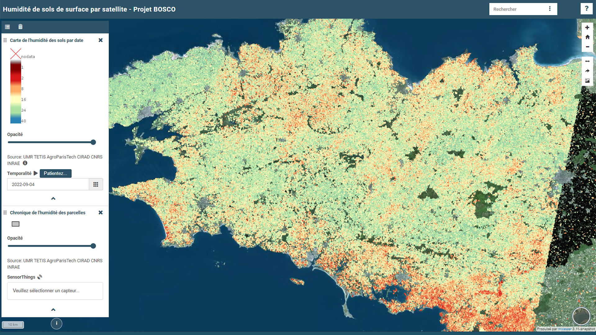
BOSCO platform
KeywordsSoil moisture, water management, agriculture, plot, public policy
BOSCO: story of a Breton co-construction
Rennes, April 24, 2025. In a light-filled room on the Beaulieu campus, the BOSCO (Bretagne: Observatoire Spatial du Contenu en eau des sols, i.e Brittany: Space Observatory for Soil Water Content) project held its closing meeting at the Rennes Environmental Science Observatory (OSERen). Coordinated by a consortium of researchers, companies, public actors, and water managers, BOSCO demonstrated the full potential of a common and homogeneous dataset, derived from remote sensing, to support integrated water management based on a consensus on water access and sharing in a region heavily impacted by the new climate regime.
A strategic challenge for local authorities
Faced with growing pressure on water resources and the need to change management practices, the BOSCO project was born out of a clear ambition: to provide reliable indicators, with very high spatial and temporal resolution, to monitor soil water content in Brittany at the plot level. This is a key issue in a region where public policies—water resource management, nitrate control, wetland protection—require high-quality data to support decision-making. By offering a unique, shared, and interoperable dataset, BOSCO provides a common basis for discussion between stakeholders with sometimes divergent interests (agriculture, drinking water supply, ecosystem restoration) in a context of climate change. The project also helps standardize regulatory analyses, ensuring their comparability and integration into existing monitoring systems.
Data for action
Thanks to close collaboration between scientists and field actors, BOSCO has made it possible to:
- Develop a product measuring surface soil water content at plot resolution (management unit) across the whole of Brittany.
👉 This homogeneous and open dataset facilitates dialogue between the various stakeholders to understand the quantities of water available and how they are shared.
- Implement the BOSCO platform for exploring this data, both in space and time.
👉 The simple temporal synthesis tool, based on "seasonal norms," complements the visualization tools by offering forecasting tools. From a technical standpoint, this is also the first coupling of two OGC data management standards ( SensorThings ).
- The development of a simple physical model that converts surface water content into both root water content (application: agriculture, agricultural disasters, ecosystem protection) and recharge (application: water supply and ecosystem protection).
-
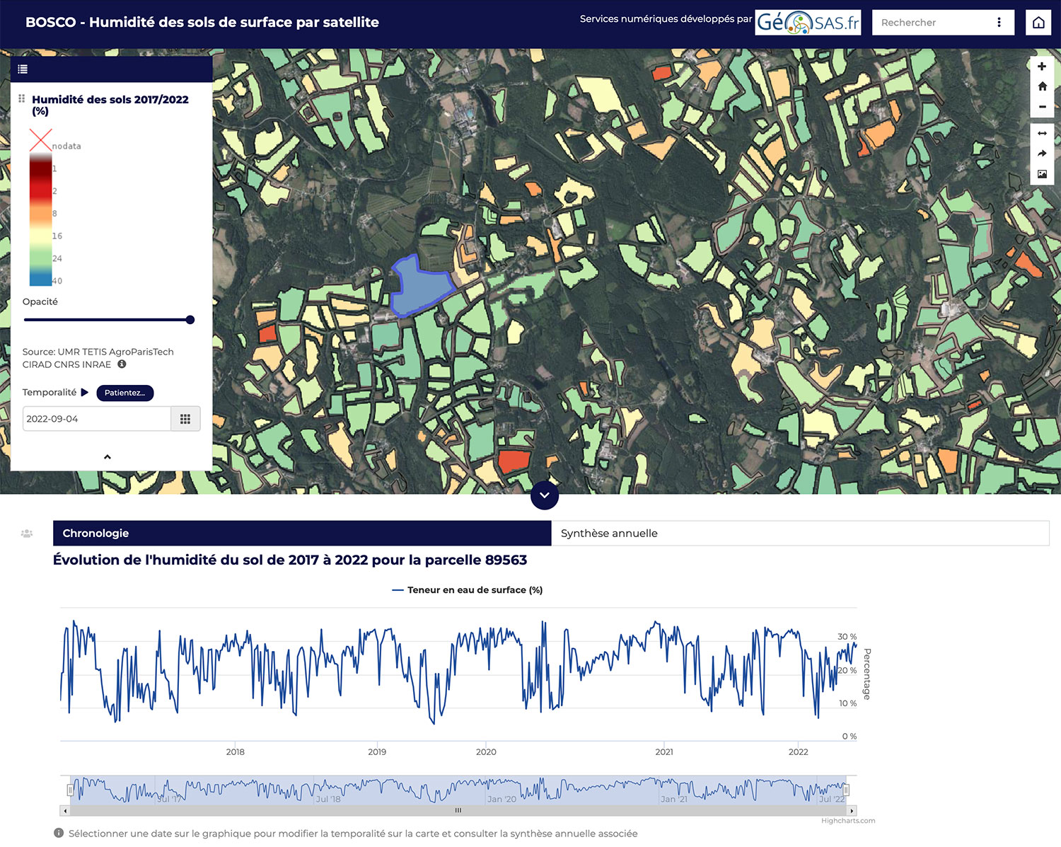
The development of indicators useful for operational management at the plot level
|
► Evolution of soil moisture for a selected plot. © BOSCO
|
|
Towards more informed public policies
Brittany Region, Ille-et-Vilaine Department, BRGM, DDTM, DREAL, Chamber of Agriculture, water unions, and basin agencies: workshops conducted with local authorities and basin unions have highlighted the value of indicators that are accessible, comparable from one year to the next, and usable at the management level. BOSCO thus shows how spatial data can become concrete levers for territorial resilience.
Feedback from stakeholders in Brittany has highlighted the value of this interoperable and meaningful data for public action.
👉 For example, DREAL Bretagne, which leads several environmental policies, sees BOSCO as a lever for objectively monitoring soil, targeting actions, and evaluating their effects over time.
👉 The BRGM has praised BOSCO's ability to reconcile local and regional scales to provide tangible answers to questions raised by elected officials and water managers. In conjunction with piezometric networks and hydrogeological models, BOSCO fills gaps, particularly in understanding groundwater recharge dynamics.
👉 For Dinan Agglomération, BOSCO could strengthen local planning in the face of droughts, identify areas at risk of runoff, and monitor the effectiveness of public policies.
👉 Opening up many other possibilities, such as combining humidity, geology, and land use data to prevent coastal risks (erosion, rockfalls), BOSCO heralds a new generation of territorial tools for resilience to climate change.
Conclusion: a seed planted for the future
Beyond scientific and technical advances, the project has helped strengthen the collective capacity to use Earth observation data to inform water management and governance choices. In the field of adaptation, BOSCO complements existing tools by providing unprecedented analytical precision.
April 25 is therefore not the end of BOSCO but, we hope, the beginning of its establishment, given its many relevant uses. Its results remain available online to continue to inform new water policies based on reliable data that is shared and co-constructed with local authorities.