

ClimHealth
Preventing epidemiological risks by monitoring the environment
Project completedIn 24 months, the ClimHealth project has developed two online early warning system demonstrators to provide information on environments conducive to disease transmission: LeptoYangon, a local tool for preventing leptospirosis in MyanMar, and ClimHealth, the generic tool that can address all diseases and symptoms influenced by the environment. Adaptable to any location, the application is open source on Framagit.
OVERVIEW
In all countries, health agencies are seeking to enhance health surveillance to better control and mitigate the impact of diseases, thereby reducing their social and economic costs. Seasonal and/or environmental diseases are mainly infectious diseases, such as vector-borne diseases (malaria, dengue fever, chikungunya, transmitted by mosquitoes) and water-related diseases (leptospirosis). For the latter, monitoring environmental and climate dynamics can help predict their dynamics in space and time.
In recent years, health systems have been improving the reporting and monitoring of epidemiological information through integration into health information systems. The World Health Organization (WHO) has thus supported the use of DHIS2 (Digital Health Information System), today deployed in more than 100 countries. Despite increasing demand from health services, these systems do not integrate climate and environmental data as predictors of health dynamics. It is therefore necessary to make knowledge from space observation of climate and the environment operationally available for health surveillance purposes.
The ClimHealth project (Climate and Environmental Monitoring for Early Health Warning) aims to develop the integration of environmental and climatic data into health monitoring information systems. It proposes methodologies and a tool for comparing data from different sources to help detect signals for early health warnings.
Application site(s)
- Yangon, Myanmar
- Thailand (provincial scale)
DATA
Satellite
Other
- Epidemiological data:
- For Year 1 (08/2020-12/2021), the project will use epidemiological data on leptospirosis in Yangon, Myanmar, from the ECOMORE II project. This project, funded by Agence Française pour le Développement, is a collaboration between the National Health Laboratory (NHL) in Myanmar, the Institut Pasteur du Cambodge and IRD, partners of ClimHealth project.
- For year 2 (2022), the project is based on the test datasets proposed for DHIS2 and on surveillance data from Thailand's Ministry of Public Health (in partnership with Mahidol University).
- Open-data: OpenStreetMap
RESULTS - FINAL PRODUCTS
ClimHealth has produced two open-access demonstrators.
LeptoYangon
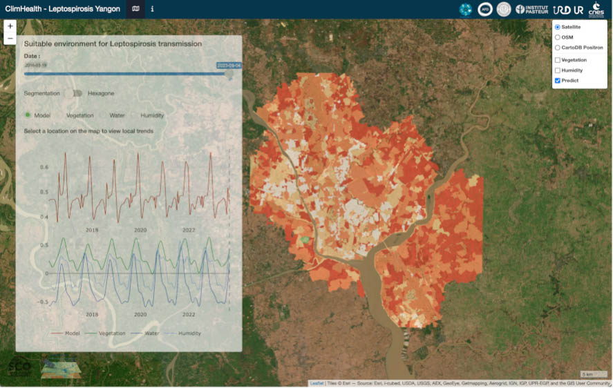
The ClimHealth project began with the development of the LeptoYangon demonstrator, in collaboration with the AFD ECOMORE 2 project in Myanmar, coordinated by the Institut Pasteur. This platform was developed to improve leptospirosis surveillance in the Yangon urban area in Myanmar.
Leptospirosis is a bacterial zoonosis strongly associated with water and the seasons, with epidemics following episodes of heavy rainfall and flooding. As part of the ECOMORE 2 project, the locations of confirmed cases of leptospirosis (vs controls) included in 2019 and 2020 were analysed retrospectively. Sentinel-2 satellite images (available at 10 metres spatial resolution, every 5 days, Copernicus Programme) are used routinely to produce time series of vegetation, water and humidity indices. They reflect the dynamics of the environment around where people live. This process is based on the use of the Sen2Chain processing chain developed as part of the TOSCA S2-Malaria project (funded by CNES) to automate the acquisition and processing of these images. The most relevant indices were used to build a spatio-temporal prediction model of positive and negative locations. This model was spatialised on homogeneous landscape units in terms of land use, describing the entire study area.
LeptoYangon is an online early warning system that provides information on environments conducive to the transmission of leptospirosis. A new risk map is produced every 5 days, as soon as a new Sentinel-2 image is available. The tool allows retrospective consultation at any date since the first image became available in March 2016 (over 7 years). This platform is designed to be used by epidemiologists and doctors to visualise the areas most at risk and those where the risk is increasing, in order to raise doctors' awareness of leptospirosis (often confused with other fevers).
This online platform has been developed using R and R-Shiny open-source software, and the processing chains are coded in Python, as part of an open science approach.
|
|
◀︎ LeptoYangon: System for monitoring environments conducive to leptospirosis. By clicking on the map, the user can select a landscape unit and view the temporal dynamics of the risk for that unit (i.e. whether the risk is increasing and decreasing). Users can also consult the vegetation, water and humidity indicators to get a more precise idea of the environmental data. © ClimHealth |
👉 See the Lepto Yangon platform
ClimHealth
The ClimHealth project then developed a generic tool for creating an interface for visualizing epidemiological data and environmental or climatic data. The aim here is really to provide an exploratory interface to visualize the possible links between temporal and spatial epidemiological dynamics and those of rainfall, temperature, or environmental indicators (such as water, vegetation or humidity indicators).
|
|
◀︎ An example of ClimHealth in use in Thailand. Adaptable to any country, the tool addresses a large number of infectious diseases and symptoms, some of which may be linked to the environment. © ClimHealth |
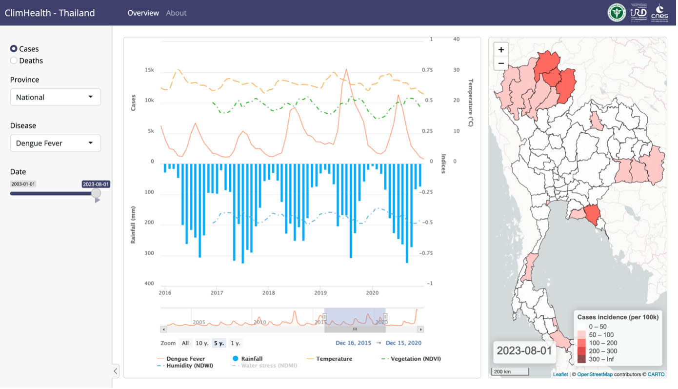
Faced with the need to set up such tools, the project set out to create a simplified application that each user would have to adapt to their needs. It is available here: https://framagit.org/espace-dev/geohealth/climhealth
The code for the Sen2Chain treatment chain, developed as part of the Malaria-S2 project, is also available in opensource: https://framagit.org/espace-dev/sen2chain
OUTLOOK
This project has confirmed the relevance of developing the integration of environmental and climatic data into the information and surveillance systems used in human and animal health. The tools developed, and LeptoYangon in particular, are a formidable demonstration of the potential of observation satellite images to predict certain risk factors for diseases linked to the environment and to provide decision-makers, at short notice, with information to which they do not have access.
There are two possible strategies:
- or develop effective integration into generic tools such as DHIS2 (Digital Health Information System), with the difficulty of producing environmental data on the fly, and potentially over large areas;
- or develop specific tools for certain diseases in predefined areas, which would make it possible to develop environmental risk models and estimates (along the lines of LeptoYangon).
References
| ClimHealth on GEO Knowledge Hub, a long lasting digital repository created by the Group on Earth Observations: https://doi.org/10.60566/kmxq2-hwc22 |
- Publication: “REMOTE SENSING AND SPATIAL MODELING - Applications to the surveillance and control of mosquito-borne diseases” published by Éditions Quae. Available in French and English. Free digital versions available at Quae.com.
RELATED PROJECTS
Project news
-
🎥 24/02/2026: Presentation of the ClimHealth project at the 3rd ClimateSCOpe “From space to health”
-
27/11/2023: When SCO's health projects become references, we zoom in on ClimHealth, selected by the WMO as a case study for its report ahead of COP28, and Arbocarto, identified by the French COVARS for the fight against arboviroses.
-
21/06/2023: Presentation of LeptoYangon at the symposium of the Réseau Francophone des Maladies Tropicales Négligées (RFMTN, Francophone Network of Neglected Tropical Diseases), in Paris (videoconference): Surveillance by spatial observation: leptospirosis. Herbreteau V., Longour L., Jégo S., July M., Goarant C., Piola P., Mouquet P., Révillion C., Bouche D., Girond F.
-
06/12/2022: Presentation of the tools at a working group on the prospects for integrating environmental and climatic data for disease surveillance, in Phnom Penh, with 24 participants involved in health surveillance in South-East Asia (Cambodia, Laos, Myanmar, Thailand, Vietnam).
-
14/11/2022: Presentation of LeptoYangon during an invited keynote at the 12ème Scientific Meeting of the International Leptospirosis Society (ILS), in Bangkok, Thailand: Leptospirosis seen from the space: tracking suitable environments for leptospirosis transmission to inform early surveillance. Herbreteau V., Longour L., Jégo S., July M., Goarant C., Piola P., Mouquet P., Révillion C., Bouche D., Girond F.
-
17/06/2022: Presentation for the TOSCA committee: "Climate and environmental monitoring for early health warning".
-
06/12/2021: Organisation of a regional workshop on ClimHealth activities: "Workshop on Climate and environmental monitoring for health surveillance", with 30 participants from Cambodia, France, Laos and Thailand.
-
25/10/2021: Remote epidemiological monitoring: presentation of the project at the 2nd Quarterly Meeting of the SCO France04/05/2021: ClimHealth step 1: demonstrator is online
-
05/2021 : Article in CNESMag 88, page 36: "ClimHealth, a space tool for public health".