

SCOFrance
5 Terabytesof data stored and used
Useful linkEO4DM project page
Key wordsDrought, remote sensing, rainfall, meteorology, agriculture
EO4DM to anticipate drought periods

Led by the company INSIGHT, in close partnership with Météo-France and with the support of the Théia data cluster, the EO4DM (Earth Observation for Drought Monitoring) project is developing a tool for monitoring and forecasting plant drought using satellite and meteorological indicators. It is taking place in New Caledonia, where the Rural Agency needs indicators to better manage agricultural activities and the aid provided for each drought.
The system
To detect agricultural drought from remote sensing, EO4DM observes three surface variables acquired in different wavelengths: vegetation condition (optical), surface temperature (thermal) and soil moisture (microwave). Once these data have been processed, the tool combines them with reference meteorological products (rainfall and evapotranspiration) from the Météo-France station network in New Caledonia. The system thus makes it possible to evaluate the intensity of drought episodes and to estimate their severity by analogy with a historical reference state (current indicators). By coupling these current data with statistical weather forecasting models, a forecast indicator provides the plausible future trajectory of a hydrological season.
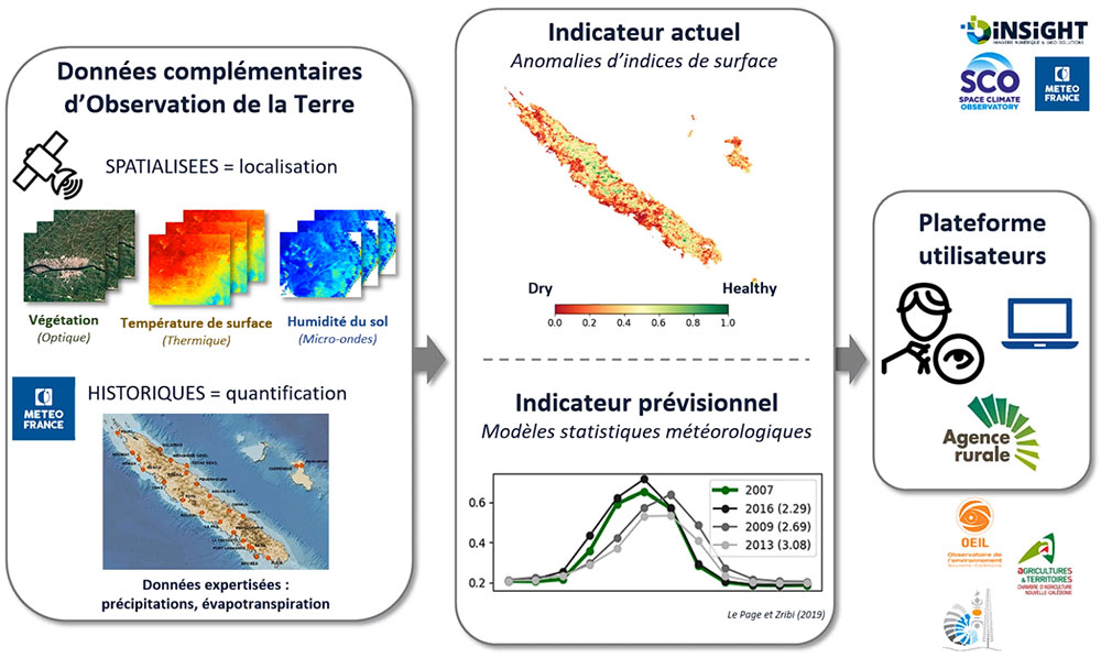
By combining 3 satellite indicators with the reference state established thanks to data from Météo-France ground stations, the system produces forecast indicators.
To achieve this, the project began with a major data collection and banking phase. Various treatments were then applied to the satellite images* to identify the most relevant indicators:
- cleaning pre-processing, especially with regard to the clouds that are very present in this part of the world;
- time composition phase in order to obtain an aggregated image every month;
- calculation of satellite indicators on a monthly time step;
- statistical analysis of correlation with the SPI weather index obtained from the cumulative rainfall over 3 months;
- creation of a combined indicator taking advantage of the different indicators studied, satellite and meteorological, to produce a drought index on the territory giving rise to global alert maps.
* Sentinel-2, Landsat, MODIS sensors (on Terra and Aqua satellites) and ASCAT (on MetOp)
3 drought information scales
To meet the need expressed by the Rural Agency for a precise breakdown of information, the team set up three levels of information: communal (according to an administrative breakdown), intra-communal(according to a thematic breakdown) and parcel-based, as close as possible to the crops. To do this, it combined several satellite (and meteorological) products defined at different spatial resolutions.
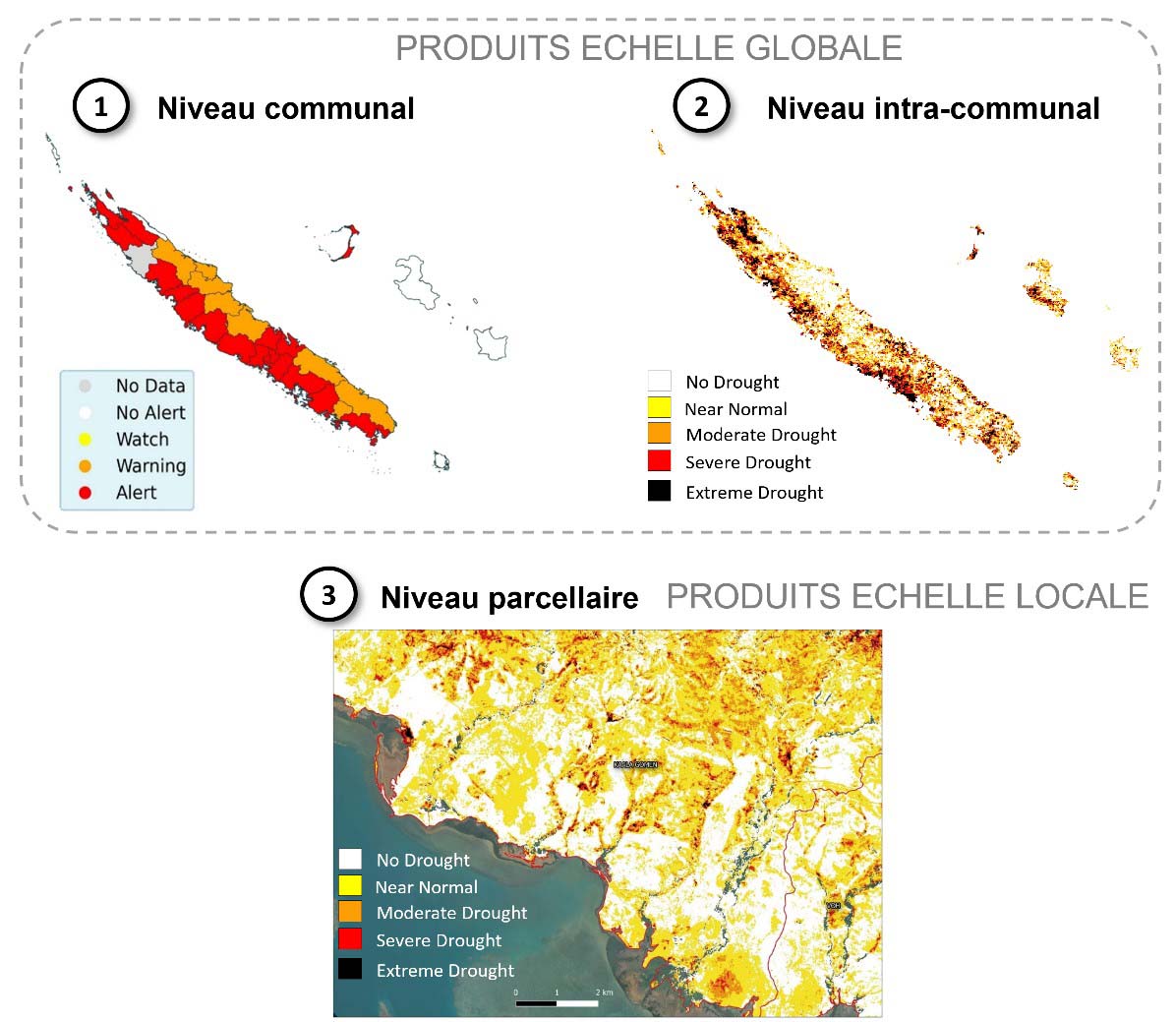
Three user levels of drought information. The global scale shows the influence of the topography of the island, which is crossed by a central chain, on the distribution of precipitations: in the west, vast plains with dry vegetation receive minimum precipitations while in the east, a mountainous relief with luxuriant vegetation benefits from maximum precipitations.
Demonstration of the visualization platform
The EO4DM interface is almost complete and is already very operational.
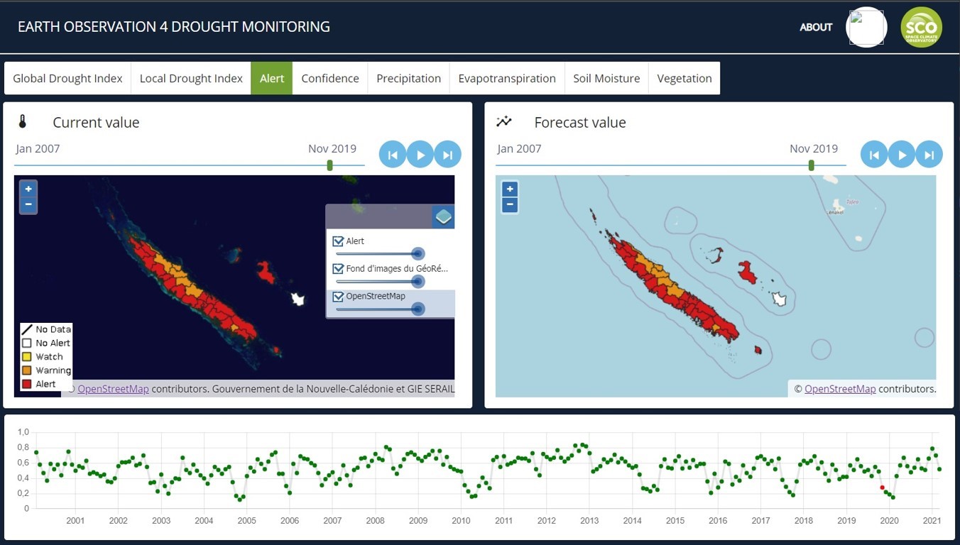
In the interface designed by INSIGHT, the left-hand window shows the past and current drought status, the right-hand window shows the forecast, and the horizontal band below shows the temporal profile of the drought.
Balance sheet: a real decision-making tool
The Rural Agency, which was present throughout the development process, is very satisfied with this innovative work, which allows it to better qualify and refine its interventions, and thus to have adapted aid, but also to work differently. For example, they will be able to correlate fodder consumption and plot yields with the state of drought in different areas. The Rural Agency now wants to open up EO4DM to farmers, who will thus be able to better anticipate and plan their production.