

SCOFrance
Key figures
- 9 consultation meetings
- 5 environnements clients
- 9 map viewers
- 30 indicators
Key wordsClimate change, observatory, water resources, renewable energies, soil erosion
Final stretch for MEO-Climate
On Monday 13 December 2021, the MEO-Climate project presented a final report with regard to its SCO labelling. This twelve-month phase, supported by CNES under the SCO programme, has enabled MEOSS to define and validate its indicators and also to draw up an economic report on its solution. Following the various presentations of this project, notably at the SCO France Congress in December 2021, the start-up is proud to announce that new partners and potential clients have expressed their interest in MEO-Climate.
As the project is scheduled to last two years, the team has an extra year with its sponsor - the collective association of municipalities managing the plan for coherent territorial development (SCoT) in Gascony - to complete everything that needs to be completed and disseminate it to the project's partner territories. Praising the quality of the work and the results, the SCO is of course continuing its support in terms of general communication and promotion.
Background
MEO-Climate is the subject of a contract between the MEOSS start-up and the collective association of municipalities managing the plan for coherent territorial development (SCoT) in Gascony. Covering almost the entire department of Gers, it includes 3 PETR (poles of territorial and rural balance), represented by the Pays d'Armagnac, Auch and Portes de Gascogne, all three partners and pilot territories for the project. Charged by the State with setting up a Territorial Climate-Air-Energy Plan (PCAET), they need enlightening indicators, the object of the development of MEO-Climate.
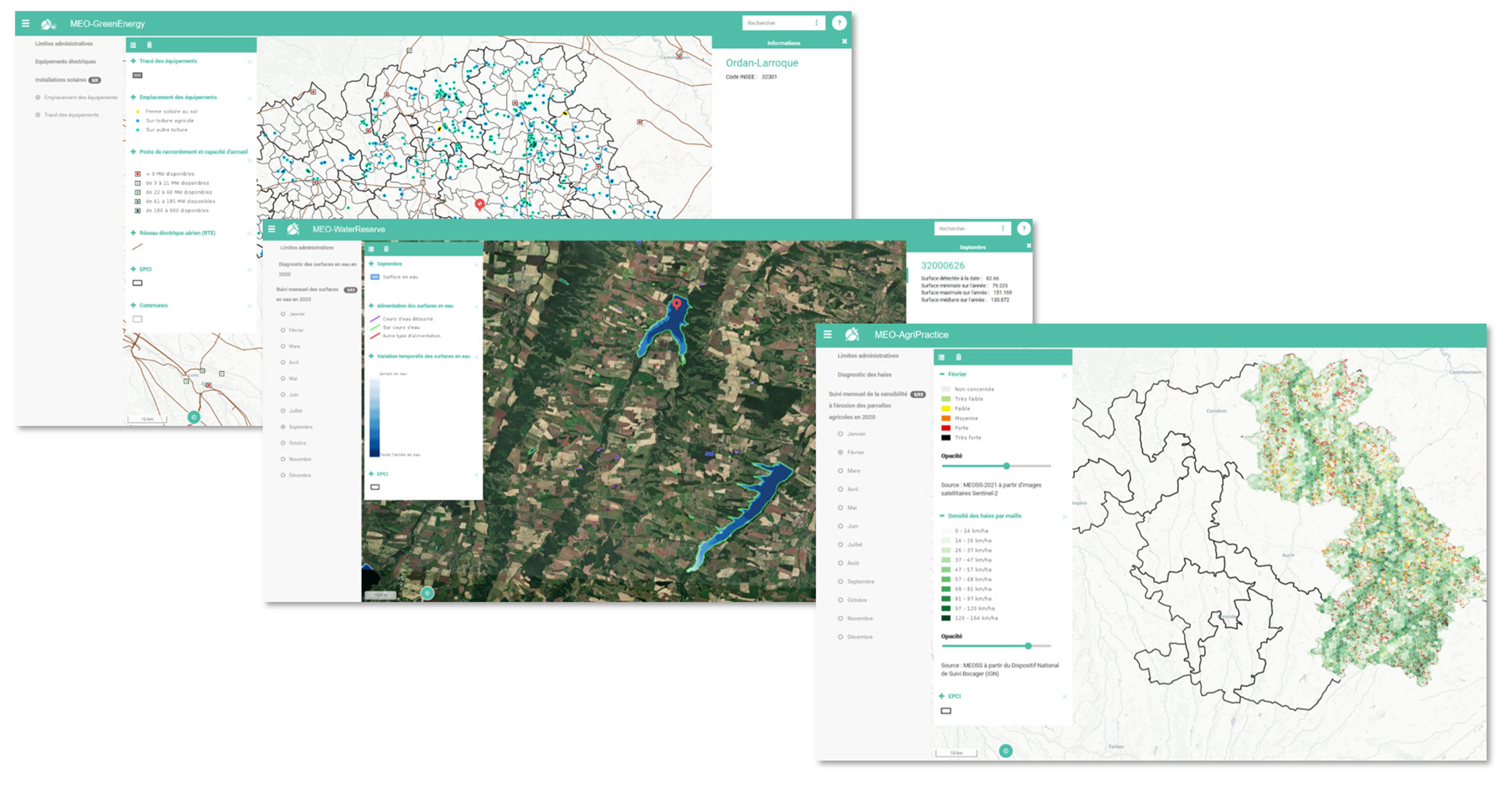
Three decision support tools
Based on regular cartographic data, MEO-Climate provides three decision-making tools to support the local management of actions related to the PCAET and the SCoT. They aim to identify the spatial and temporal evolution of water surfaces, the risks of erosion of agricultural plots and the equipment dedicated to solar energy production.
Over the past six months, the MEOSS team has been working in greater depth on the value proposition of its indicators in relation to climate change and the territory's strategic objectives:
- GreenEnergy: identifying existing solar installations and connection capacities
=> Issue : reducing energy consumption and GHG emissions, especially CO2, and to prepare for the energy transition.
NB: as the strategy of the pilot territory has not yet been defined on this theme, the project has produced a consultation map to be used during the energy transition conference organised by the Gers Chamber of Agriculture in October 2021.
- WaterReserve: visualise the inter and intra annual dynamics of water surfaces and identify those that will be fed or not in a drought episode
=> Issue: ensuring the resilience of the territory in terms of agricultural water resources
- AgriPractice: identifying agricultural plots at risk of runoff erosion
=> Issue: reducing the sensitivity of bare soil to erosion
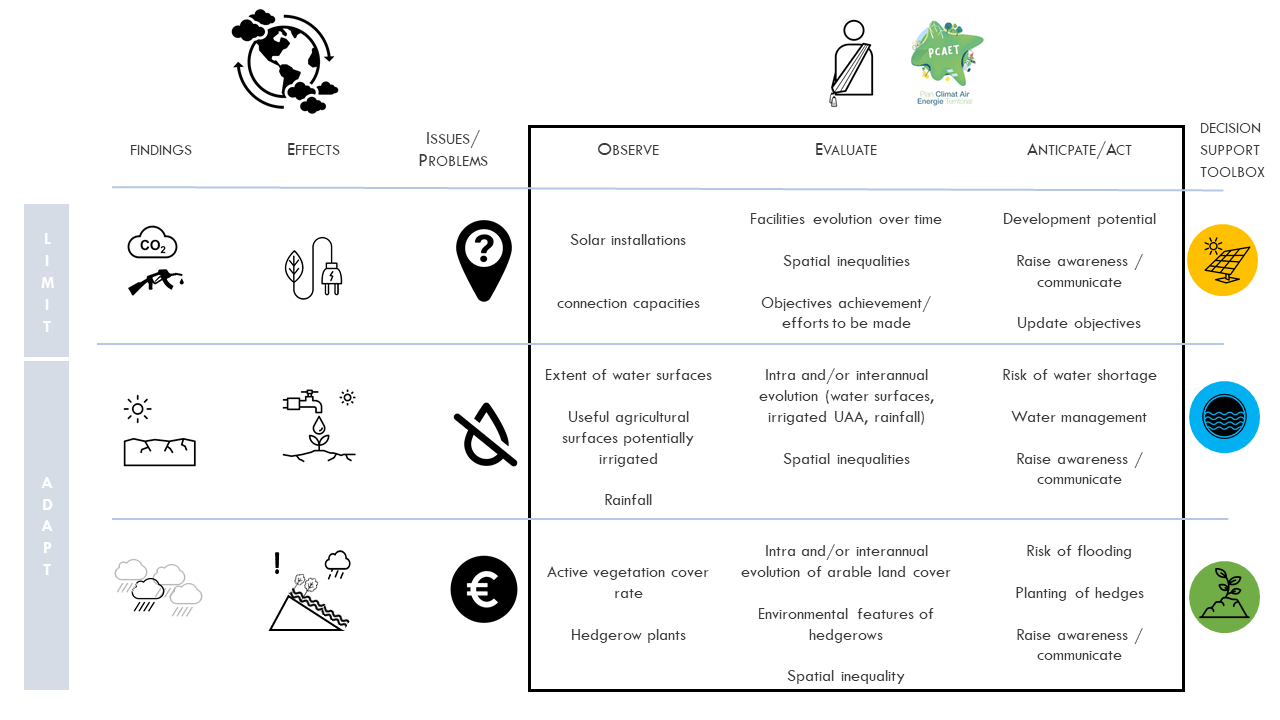
MEO-Climate offers decision support tools based on the observation, evaluation and anticipation of the impacts of climate change with regard to the strategic issues and objectives of the territory. The team has created popularised visuals such as this one to facilitate exchanges with the territory's stakeholders.
Thanks to an application accessible via the Web, each PETR and the Syndicat Mixte du SCoT have access to the products developed on their territory and a summary technical sheet to make the best use of the interface.
=> In 2022, the indicators, each developed on the scale of its pilot territory, will be applied to the other territories of the SCoT de Gascogne.
Additional elements
In order to produce a tool that is in line with the real issues, MEOSS has not hesitated to work on needs that were not initially foreseen but that emerged during the consultation phases with the territories. At the same time, new meteorological data bricks are being explored to meet the challenges of climate change.
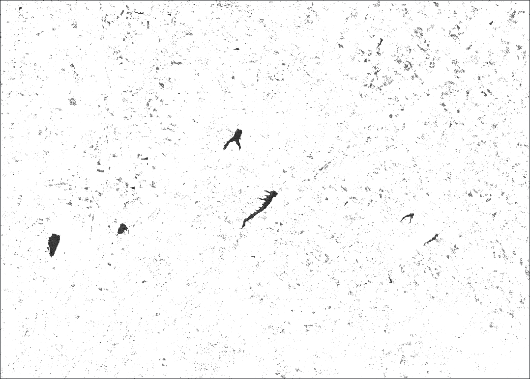
Test of detection and monitoring of temporary water areas from radar data. This product will be consolidated in 2022 if the team finds enough field data to qualify this information.
See the details of MEO-Climate and its indicators on the project page. The presentation sheets for each product are also available there.