

MEO-Climate

Supporting the transformation of rural areas
Project completedMEO-Climate is a two-year project and has been awarded a SCO label for the first twelve months. This phase has enabled the MEOSS project leader to define and validate its indicators and its web platform, as well as to make an economic assessment of its solution.
OVERVIEW
Climate change is the defining issue of our time and we are at a critical juncture. Changes in the intensity and frequency of extreme events, such as heat waves, storms, droughts and floods, expose territories to new risks. Without immediate action, it will be much more difficult and costly to adapt to the future consequences of these changes. In order to diagnose and support local authorities in reducing the vulnerability of their territory and to promote their resilience, MEOSS is mobilising for the adaptation and transition of territories on the themes of water, renewable energy and agriculture.
The MEO-Climate service is directly developed with the objective of regular and operational provision of cartographic data to local authorities and other local or national stakeholder. The task at hand is carried by the means of three indicators meant to support the establishment of the Territorial Climate Air and Energy Plans (PCAET) and Territorial Coherence Schemes (SCoT) and done by providing informational and coherent cartographic content
MEO-Climate is proposed in the form of three decision support tools that aim to identify spatial and temporal changes in water surfaces, erosion risks on agricultural plots and equipment dedicated to solar energy production.
The indicators are intended for the concerned local elected officials, departmental services and citizens of the Gascony SCoT. They are particularly relevant in rural areas, where certain land management practices, and especially agriculture and water reserves management, represent important elements of local environmental steering practices.
Application site(s)
SCoT of Gascony (South-Western, France)
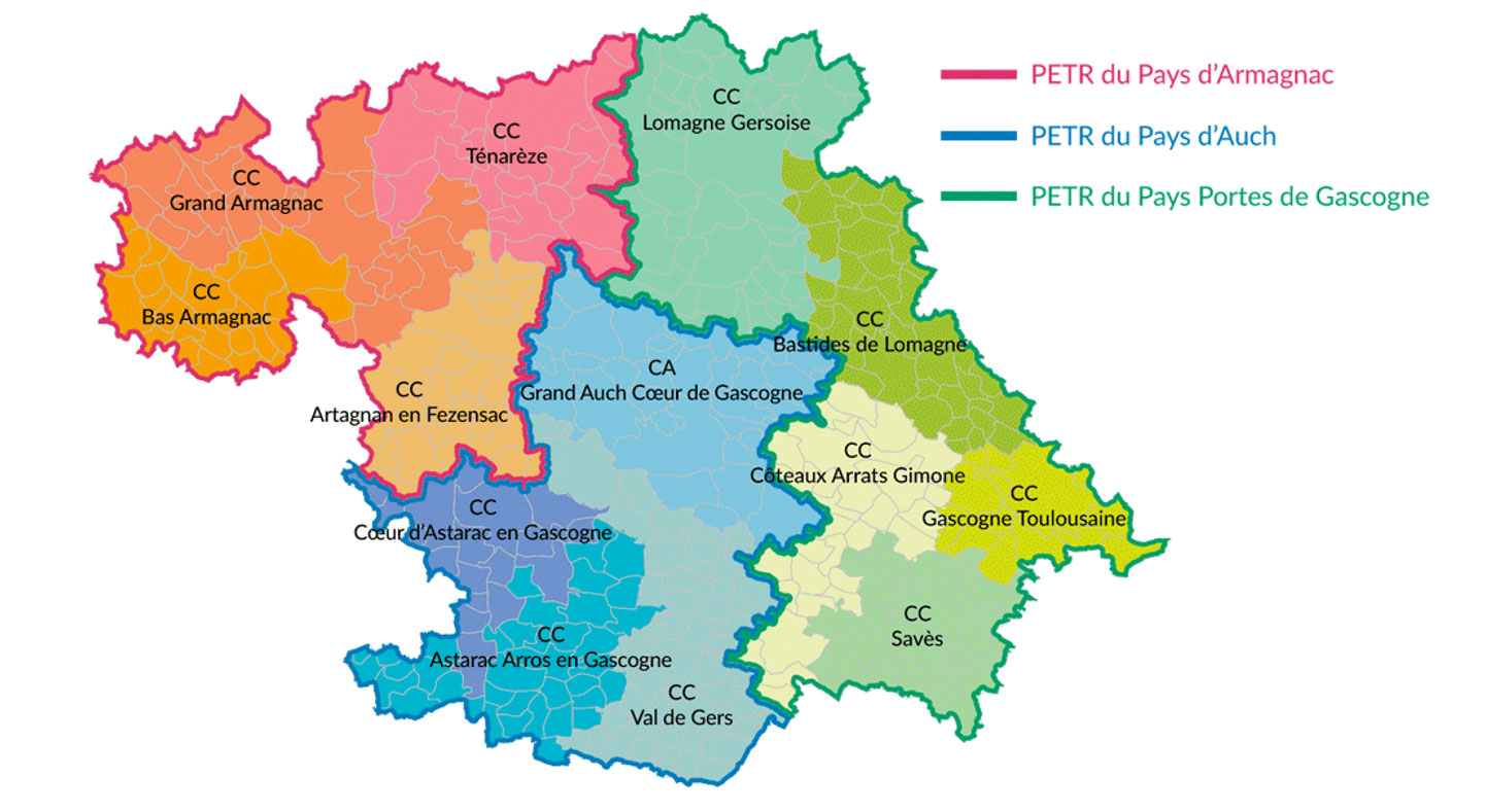
The Territorial Coherence Schemes (ScOT), a strategic document, is a territorial planning tool. The SCoT is supported by a collective association of municipalities which sets the priorities in terms of public policies (housing, economy, commercial development, equipment, mobility, environment, etc.) of the territory, in order to meet the needs of the population. This collective association of municipalities is made up of 13 Public Establishments of Intercommunal Cooperation (EPCI):
- 4 EPCIs that make up the PETR Pays d'Auch;
- 4 EPCIs that make up the PETR Armagnac;
- 5 EPCIs that make up the PETR Portes de Gascogne.
The communities concerned by the SCoT are involved in and collaborate on planning projects and issues, particularly in relation to climate change.
DATA
Satellite
- Copernicus – Sentinel-1 & -2
Other
- Aerial photographs (IGN BD ORTHO)
- Open-data: IGN data (BD TOPO, MNT), French public data (RPG, water surfaces, BD TOPAGE)
- Other proprietary data from EPCIs
RESULTS - FINAL PRODUCTS
MEO-Climate and its information are accessible through a webservice application developed by MEOSS. This web sharing tool provides files in a standard format that can be integrated into any type of Geographic Information System (GIS), as well as maps that can be accessed online with a login and password.
This information can also be directly integrated into an existing information system, for example at the level of a local authority.
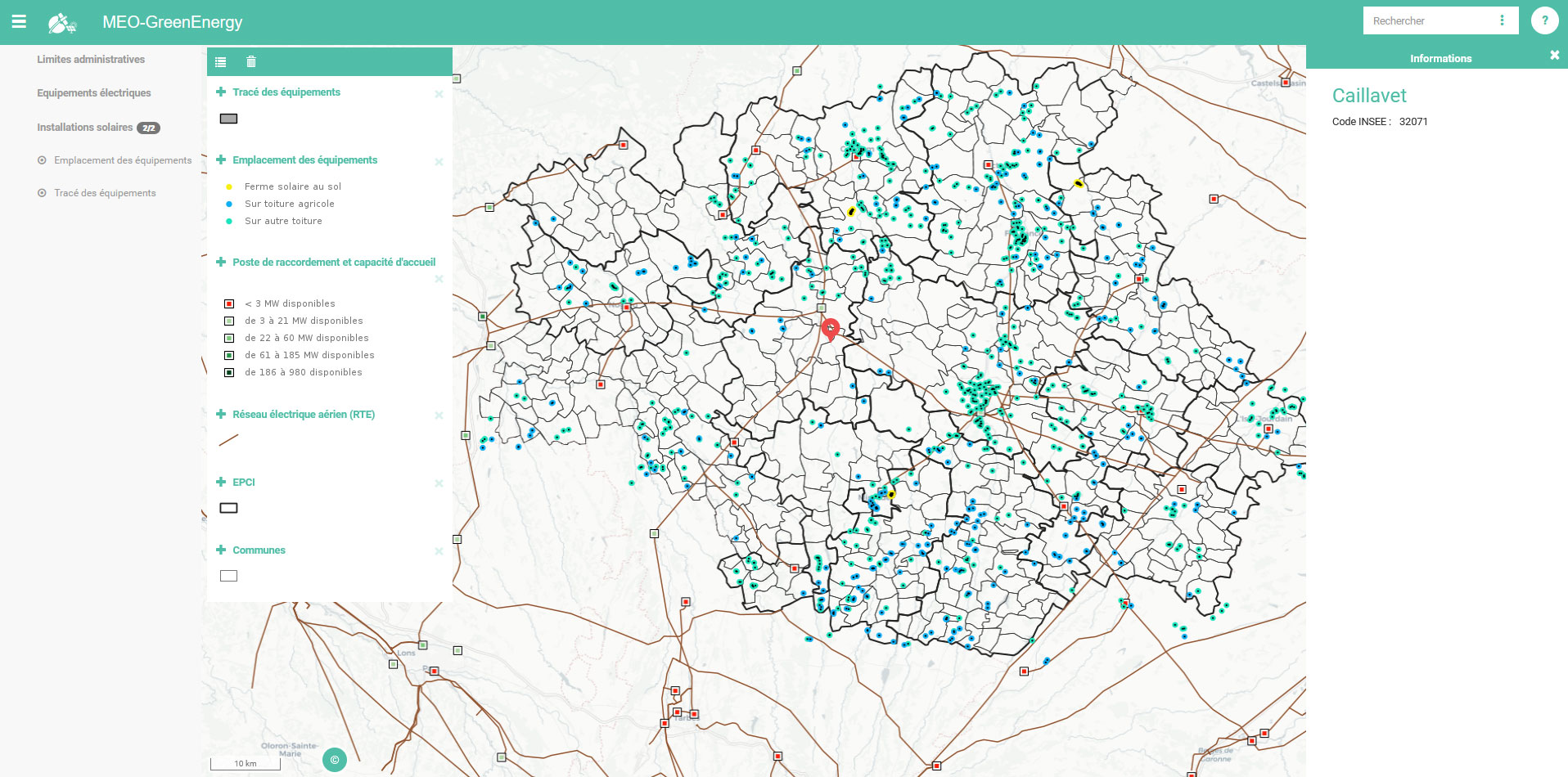
1GreenEnergy Tool
The development of renewable energies is an important element in the strategy of the territories, for which the establishment of a diagnosis of the existing situation is essential.
The GreenEnergy tool now focuses on solar energy production and offers a mapping environment accessible via the internet:
- An inventory of installed solar photovoltaic panels;
- A visualization of the electricity distribution networks, substations and their connection capacity;
- A multi-criteria assessment to identify potential sites for the installation of solar equipment (under development).
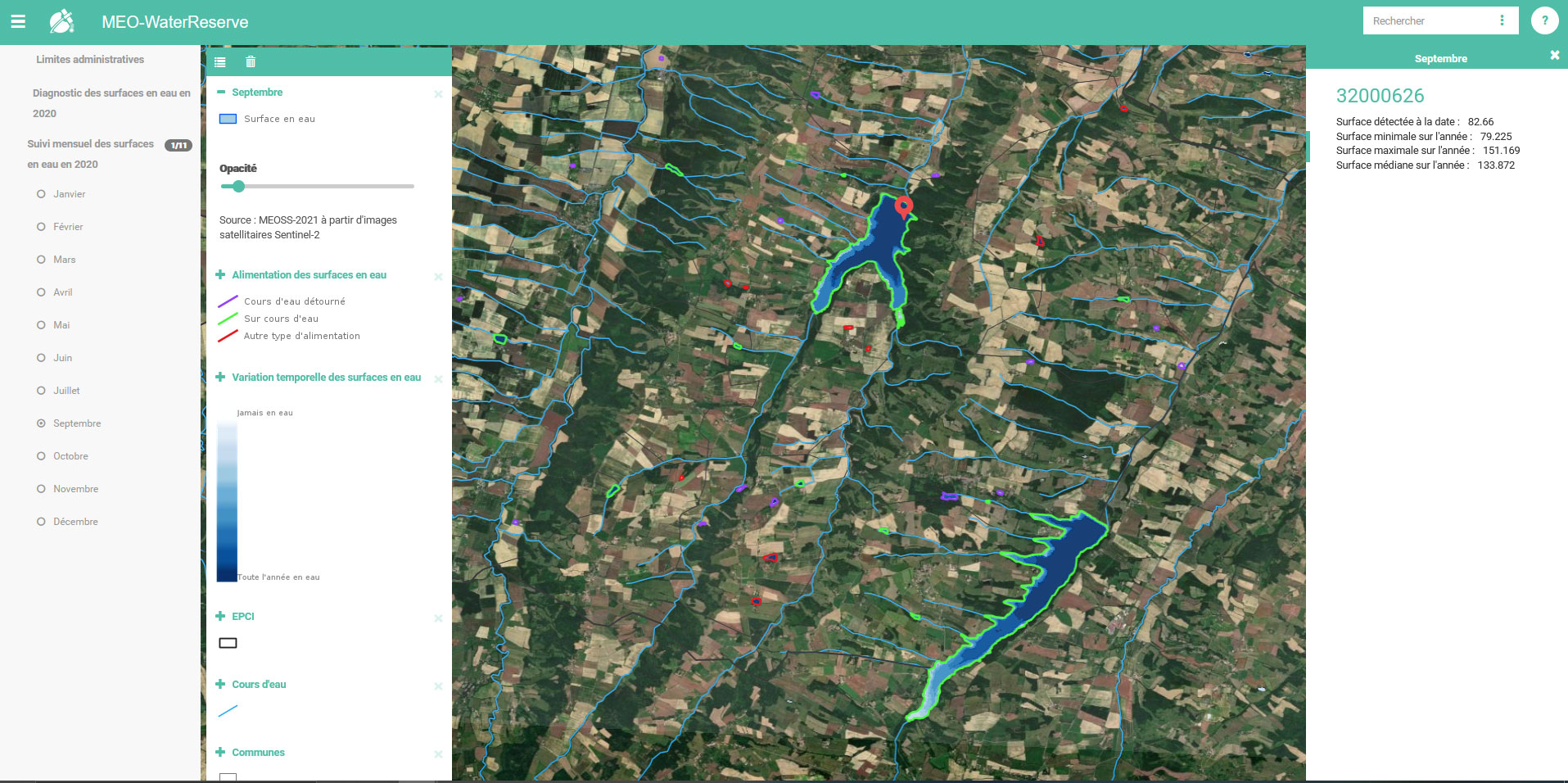
2WaterReserve tool
Water management and drought risk issues are critical in the context of climate change and are an integral part of the PCAETs and SCoTs.
The WaterReserve tool centralises a panel of cartographic indicators dedicated to the intra and interannual monitoring of water surfaces. WaterReserve includes :
- A monthly inventory of water surfaces;
- A summary cancels out the water surfaces (minimum, maximum and median surface);
- The distribution of water surfaces per catchment area;
- The method of supplying water to surfaces.
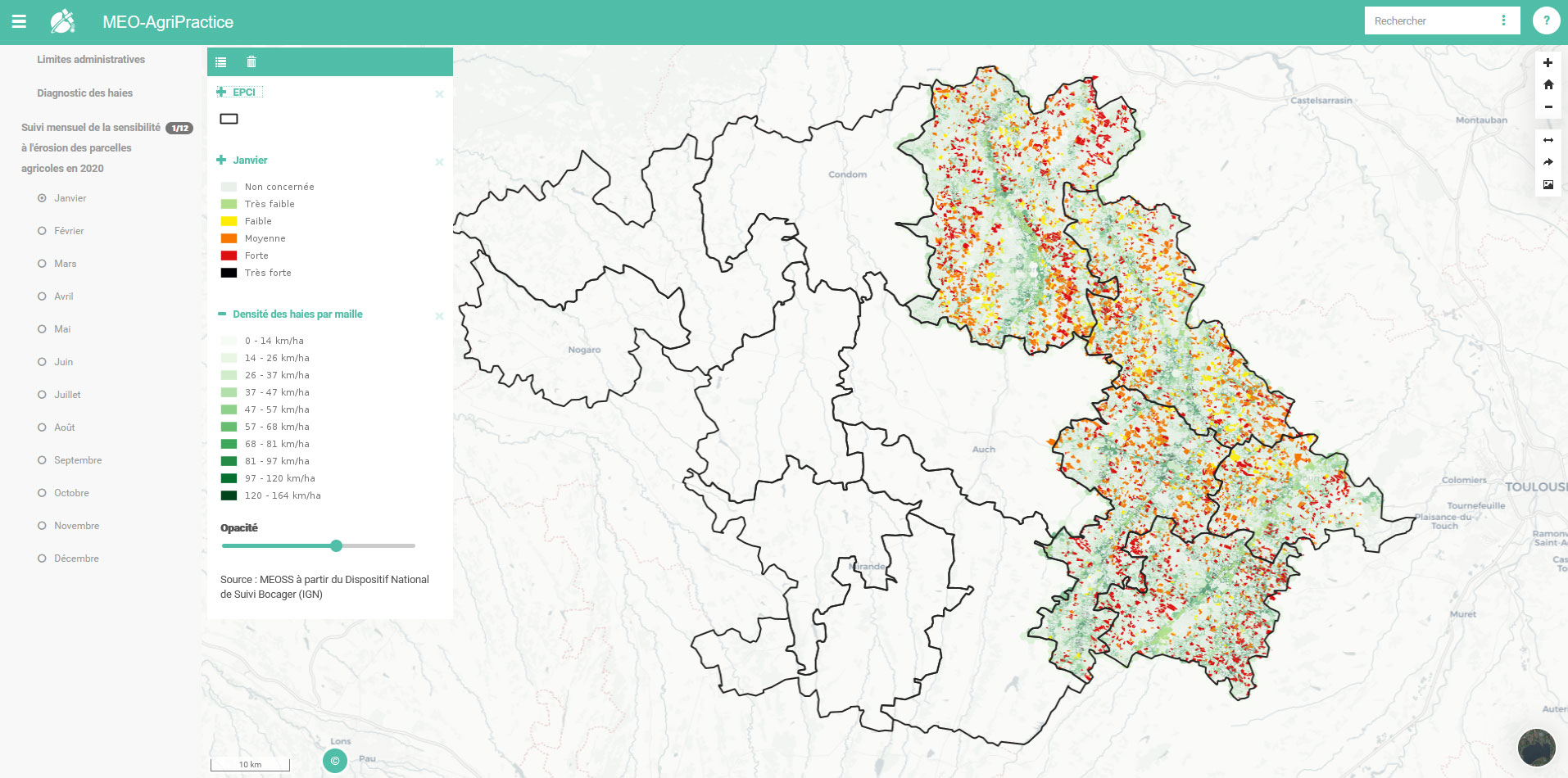
3AgriPractice tool
Due to its topographical characteristics, the experimental area is particularly subject to the risk of runoff, with numerous mudflows during heavy rainfall. Cultural practices and agro-ecological developments are levers for action to limit the risk, which is particularly increased in the context of climate change.
The AgriPractice tool identifies the risk sensitivity of agricultural plots to help decision-makers implement adaptation measures. The level of sensitivity is calculated according to several parameters such as vegetation cover, slope or hedge line. The indicators available in the tool are :
- The gridded density of hedges;
- Characterisation of hedges according to their role (under development);
- The vulnerability of agricultural land to monthly erosion;
- An annual summary of the vulnerability to erosion of agricultural land.
Market Place
 |
MEO-Climate solutions on GEO Knowledge Hub, a long lasting digital repository created by the Group on Earth Observations: https://gkhub.earthobservations.org/marketplace/items/crse7-zqa58 |
Related projects
PROJECT NEWS
- 04/17/2024: WaterReserve tool powers French water monitoring and management portal. Read more in SCO France at the forefront of the future national hydrological service
- 31/01/2022: European data at the heart of SCO projects, including a video on how the TropiSCO project uses Copernicus data
- 21/01/2022 : Final stretch for MEO-Climate
- 19/07/2021: MEO-Climate: mid-term update
- 23/11/2020: MEO-Climate, official launch in the Gers region