

EO4AgriWater
Earth Observation for Agricultural Water monitoring
Project completedThe EO4AgriWater project was completed in August 2025 after developing a knowledge and decision-making support tool for smart water resource management in the agricultural sector. The tool combines global indicators for monitoring plant drought anomalies and irrigated plots, crop characterization, and water body monitoring in three pilot areas, including Gers and Alsace. Due to the landscape and agricultural context of New Caledonia, which is very different from that of mainland France, the pilot area of Pouembout was able to benefit from drought monitoring only. The data produced is accessible to project partners (Chambers of Agriculture) via a web-based mapping platform.
Overview
Context
Recent droughts have highlighted the dramatic consequences of reduced rainfall and insufficient water resources. In mainland France, many departments have had to implement irrigation restriction orders, forcing farmers to reduce or completely stop irrigating their crops. In New Caledonia, prolonged droughts have also led to a significant reduction in water resources, seriously affecting farming activities. Faced with these challenges, it is imperative to have accurate information and effective means for integrated irrigation water management. The development of innovative tools based on satellite imagery and cutting-edge technology offers promising possibilities.
Precise identification of irrigated agricultural plots from satellite data enables the relevant authorities to better assess water demand and implement appropriate measures. Spatial monitoring of crop drought is essential for detecting signs of water stress and taking preventive measures to minimise and quantify agricultural losses. In addition, water availability in reservoirs, assessed from Earth observations, is a key indicator for effectively planning irrigation water supplies and avoiding shortages.
The project
As part of the EO4AgriWater project, the Toulouse-based company MEOSS and the New Caledonian company INSIGHT have joined forces to capitalise on and extend their R&D work on the themes of water and agriculture, carried out during their previous projects under the Space for Climate Observatory label. These projects have led to the development of operational tools in mainland France and New Caledonia for monitoring crop drought (EO4DM, INSIGHT), monitoring water bodies (MEO-Climate, MEOSS) and identifying irrigated crops (Space4Irrig, MEOSS).
The objectives of EO4AgriWater were to confirm the robustness of the models developed during previous SCO projects (new experimental sites), to test their transferability to other territories (from New Caledonia to France and vice versa) and, above all, to carry out a joint analysis of all the results to provide a summary indicator (drought/irrigation/water).
To achieve these ambitious objectives, MEOSS and INSIGHT have surrounded themselves with several key partners from the agricultural world in mainland France (the Gers and Alsace Chambers of Agriculture) and New Caledonia (the N-C Chamber of Agriculture and Fisheries, the Rural Agency), to provide business expertise. Scientific experts (UMR CESBIO and UMR Espace-Dev/IRD) are participating in the consortium to validate the methodological approaches and results.
Methodology
The project was broken down into Work Packages (WP) leading to the development of a decision-making tool for the experimental areas:
- WP1 : Link with end users: Defining user profiles and their needs, validating the decision-making tools produced during a user test phase.
- WP2: Plant drought indicators: Locating and monitoring plant drought trends using satellite data
- WP3: Irrigation and characterisation indicators: Identify irrigated plots and characterise crop types using satellite data
- WP4 : Indicators for monitoring water bodies: Identify and monitor changes in the surface area of water bodies using satellite data
- WP5 : Decision support tool: Working with partners to develop summary indicators that are easier to interpret, to support decision-making, and to develop a demonstrator (web-mapping platform).
- WP6 : Coordination with partners: Ensuring that the project runs smoothly
Application site(s)
- Department of Gers, France
- Department of Alsace, France
- New Caledonia
Data
Satellite
- Radar: Copernicus Sentinel-1
- Optical: Copernicus Sentinel-2 and Landsat-9 (10-30 m)
- Thermal: MODIS (500 m)
- Microwave: ASCAT/SMAP (for soil moisture)
Other
- Meteorological data: CHIRPS precipitation and drought indicators (SPI/SPEI) from Météo-France stations
- Data science: long-term observations to differentiate between one-off phenomena and structural variations. Machine learning algorithms trained on more than 3,200 reference plots collected in the field
- Co-construction: participatory workshops with end users to adapt indicators to operational needs
Results – Final product(s)
The project developed the EO4AgriWater tool, whose results are displayed on a web-based mapping platform accessible to the project's institutional partners (Chambers of Agriculture, water managers).
The EO4AgriWater tool offers four main modules:
|
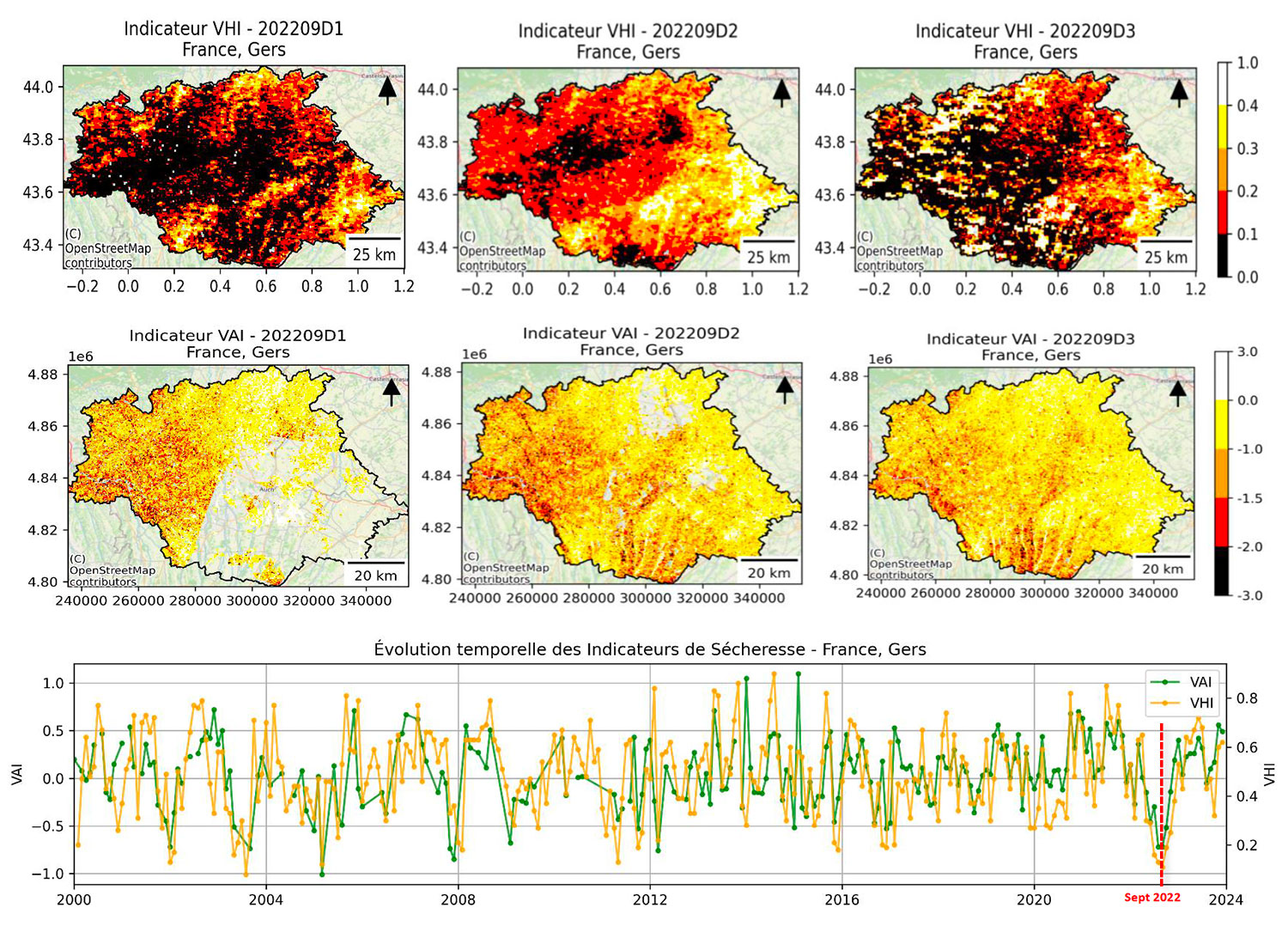
1. Plant drought indicators
► Map of VHI/VAI indicators in the Gers department (September 2022) © MEOSS / INSIGHT |
|
|
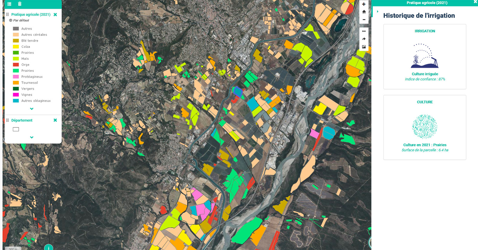
2. Mapping of irrigated plots and crop characterization
► Irrigated plots and crops © MEOSS / INSIGHT |
|
|
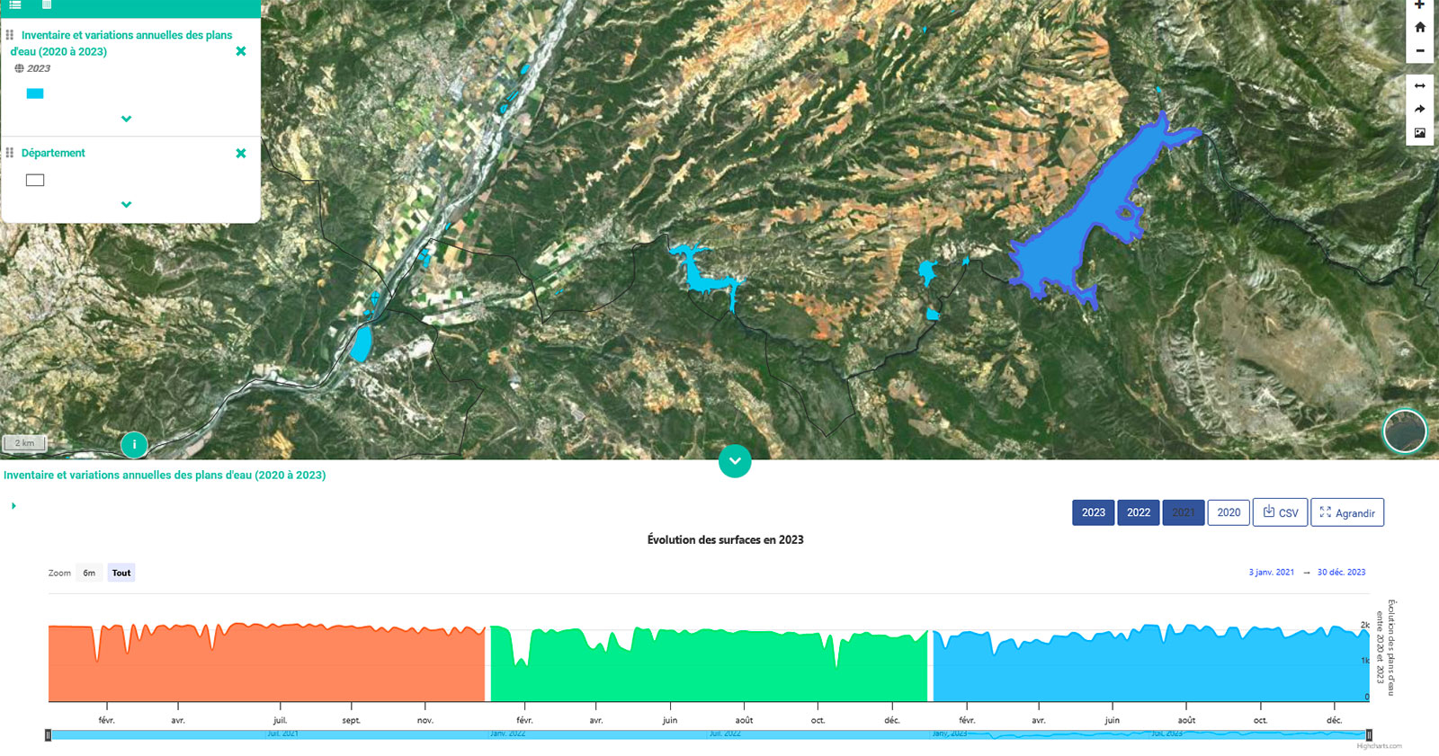
3. Monitoring of water bodies
► Temporal monitoring of water bodies © MEOSS / INSIGHT |
|
|
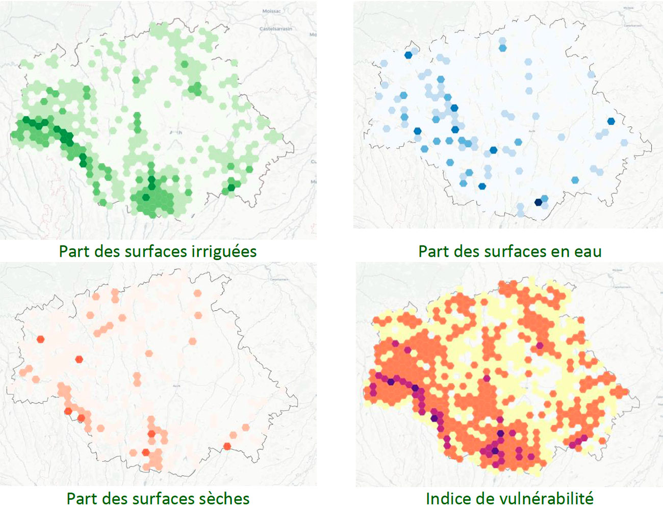
4. Summary vulnerability indicator
► Aggregation of data to generate a vulnerability index. © MEOSS / INSIGHT |
|
💡 For more information on the methodology and results, see the Final Report, available for download in the Resources section below.
Outlook
The EO4AgriWater project has demonstrated the transferability of the methods developed in metropolitan areas. However, the context in New Caledonia is not suited to the methods developed for detecting irrigated plots in metropolitan France. Prospects for development include:
- Enrichment of data sources: future integration of TRISHNA missions (2027, surface temperature).
- Geographical extension: adaptation of models for nationwide production in metropolitan France
- Integration of additional data: reservoir water volumes, groundwater levels, river heights and flows.
- Evolution towards an operational service: complete automation of the production chain for large-scale deployment.
- New SCO VULANMEX* project dedicated to monitoring drought, water reservoirs, and agronomic data for corn fields in an experimental area located in Mexico. The resulting decision support tool will demonstrate the scalability of EO4AgriWater solutions internationally.
The tools developed provide a solid foundation for strengthening the resilience of the agricultural sector in the face of increasing water stress linked to climate change.
Related projects
-
MEO-Climate, led by MEOSS and awarded the SCO label in 2020. This project has led to the development of the MEO-WaterReserve tool, dedicated to the identification and surface monitoring of water bodies using satellite images. MEO-WaterReserve is intended for use by land managers and for planning purposes, and has enabled the project partner to improve its knowledge of the levels of use of hill reservoirs.
-
EO4DroughtMonitoring, led by INSIGHT and awarded the SCO label in 2021. This project has enabled the development of a decision-making tool for institutions and a management tool for the agricultural sector. The system is capable of assessing the intensity of drought episodes, estimating their severity by analogy with a historical reference state and, coupled with current data, providing an indication of the plausible future trajectory of a hydrological season.
-
Space4Irrig, led by UMR CESBIO and MEOSS, and awarded the SCO label in 2021. This project has developed methods for identifying irrigated crops and the MEO-Irrigation decision-support tool for water managers. The mapping tool brings together a number of indicators to improve knowledge and identify effective water resource management strategies for the future.
- VULANMEX: for this project, accredited with SCO in 2025, MEOSS has partnered with the National Polytechnic Institute of Mexico (IPN) to transfer and adapt the tools developed for France to central Mexico, where corn production is particularly threatened by climate change.
Project news
- 6/11/2025: EO4AgriWater: Satellite innovation at the service of agriculture and water
- 🎥 22/09/2025: Presentation of the EO4AgriWater project and its progress at the 18th SCO France Quarterly Meeting