

Space4IRRIG
 and irrigation")
Tool for identifying, characterizing and monitoring irrigated crops
Project completedThe project has developed a method for identifying irrigated and non-irrigated crops, which has been tested and validated on two experimental territories, several crop types and several years. The results are available via a mapping platform (MEO-Irrigation) and enhanced with data visualizations. Other spatial indicators have been added to enhance users' knowledge, such as volumes withdrawn for irrigation, water surface monitoring and water quality. Users are thus free to cross-reference the desired indicators, track temporal trends and obtain key figures on a territorial scale (topographical basin, canton).
OVERVIEW
In France, for the past ten years, many departments have resorted to water restrictions, particularly in the agricultural sector. This figure reached a record high in 2020, where 80 departments were subjected to drought orders. For instance, in the Adour-Garonne basin, the average annual temperature could increase by 3.5°C which implies major changes in hydrology with the transition from a nival system to a rainy system (Garonne study, 2050). Moreover, since the 1970s, irrigation has rapidly developed on all continents and is considered as an essential tool for maintaining economic performance. The FAO (Food and Agriculture Organization of the United Nations) estimates that in 2025, 80% of expected food needs will be covered by irrigated agriculture. However, the use of irrigation has led to conflicts of use that are likely to worsen with climate change and future droughts.
Meeting this challenge requires a good knowledge of the available resources on specific territories. Satellite images can play an essential role in this context. Until 2016, remote sensing images had temporal and/or spatial frequencies unsuited to the challenges of water management. This requires constant monitoring of surfaces at high temporal and spatial frequency. Since 2016, thanks to the Copernicus program, we have satellite images with high spatial (10 m) and temporal resolution (5 days with S2 optical sensors and between 15 and 20 images per month with S1 radar sensors) available in near-real time around the globe. This program offers new opportunities to meet the challenges of water management.
Application site(s)
- Loiret Department (45)
- Durance Valley Watershed (13)
DATA
Satellite
- Copernicus Sentinel-1 (radar)
- Copernicus Sentinel-2 (optical)
Other
In-situ surveys provided by partners on irrigation and crop type
RESULTS - FINAL PRODUCTS
Supported by CESBIO and MEOSS, the Space4Irrig project has developed a method and a decision-making tool for water managers. The MEO-Irrigation platform brings together cartographic indicators produced from Sentinel-1 and Sentinel-2 time series. The role of these indicators is to facilitate objective diagnoses of crop irrigation, which can then be reproduced in other areas. The improved knowledge provided by these indicators makes it possible to adopt relevant strategies for adapting to climate change.
|
The tool offers some twenty cartographic indicators on the themes of irrigation, continental surface water and water quality. The aim is to present the results obtained as part of the project, formatted for operational use. The platform is also enriched by other results produced by MEOSS (MEO-WaterReserve, result of the SCO MEO-Climate project) or other data sources. |
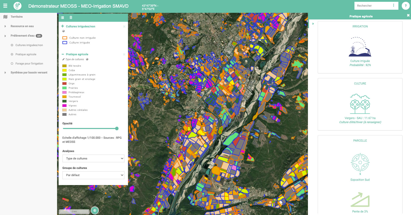
Figure 1: Mapping agricultural practices in the MEO-Irrigation interface. © MEOSS |
The indicators available within the tool are (non-exhaustive list):
- 2017 farming practices (type of crop and irrigation, Figure 1),
- Irrigation history on corn from 2017 to 2020,
- Irrigation practices by crop in 2017,
- Evolution of irrigated UAA from 2017 to 2020,
- Water withdrawal by borehole from 2017 to 2020,
- Monitoring of water bodies from 2017 to 2020 (Figure 2)
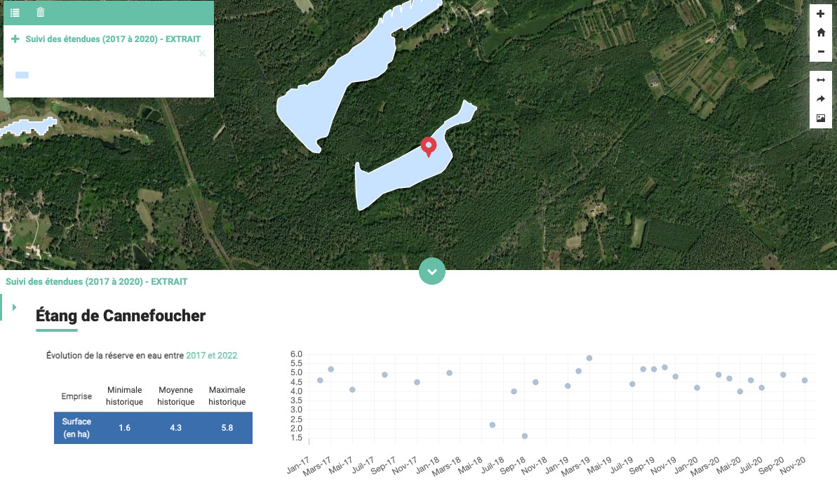
Figure 2: Example of water body monitoring. © MEOSS
Documentation has also been produced to help non-expert users understand and use the tool.
OUTLOOK
- Generalization of the method to other regions and on a national scale
- Generalization of the method to other crop types
- Development of a semi-automatic irrigation detection method
- Cross-reference these results with other products, in particular the drought monitoring system developed by INSIGHT (SCO EO4DroughtMonitoring New Caledonia project).
Market place
 |
Space4IRRIG on GEO Knowledge Hub, a long lasting digital repository created by the Group on Earth Observations: https://gkhub.earthobservations.org/marketplace/items/6evd0-wda08 |
Related projects
PROJECT NEWS
-
04/17/2024: MEO-Irrigation tool powers French water monitoring and management portal. Read more in SCO France at the forefront of the future national hydrological service
-
02/10/2023: Space4IRRIG presents MEO-Irrigation, the tool for monitoring irrigated plots and their crop rotation
-
29/06/2023: Presentation of the Space4IRRIG project and its progress at the 9th Quarterly Meeting of the SCO France "The SCO serving agricultural practices".
- 16/03/2023 : Space4IRRIG, significant progress, with an accuracy of 81 to 97% of the results