

SCOFrance
Duration of experimentation12 months
KeywordsWater management, agricultural practices, energy
MEO-Climate: mid-term update
Six months after its official launch in the Gers, the MEO-Climate project has delivered its first deliverable, a report on the consolidation of the needs of local authorities and other users in relation to the three mapping indicators that the Web platform will deliver.
Preamble
With three indicators under development, the project is being tested on the territory of the SCoT (territorial coherence scheme / Schéma de cohérence territoriale) of Gascony, divided into three PETR (centres for a territorial and rural balance). As a pilot user, the collective association of municipalities for the local SCoT has assigned an indicator to each of these three sub-territories. As the project leader and developer of the tool, MEOSS met with each of these PETRs during technical committees that mobilized a strong participation of technicians and thematic experts from each territory: chamber of agriculture, departmental council, DREAL, hunters' federation...
Six months of intense exchanges have allowed us to confirm the needs of future users, to make them aware of the technologies implemented by MOE-Climate and to collect their data. It is commonly agreed that 2020 will be the reference year for the indicators.
The final service is based on a web mapping application, whose ease of use is a major element of the development. This interface is based on the geOrchestra solution, which is already widely used by the territories and which enables data to be delivered in GIS format.
Indicator 1: WaterReserve, a dynamic mapping of water reserves
WaterReserve allows the detection and monitoring of open water areas, permanent or intermittent. It also aims to identify the most suitable areas for the implementation of water reservoirs.
It relies on two types of satellite data:
- Sentinel-2 high resolution optical data for a first level of detection of open water surfaces => with more than 95% reliability, the results are satisfactory;
- Sentinel-1 radar data to complete the detections with intermittent water surfaces, a need identified during the technical committees => with 80% of the basins smaller than 0.5 ha, the relief of Gers complicates the detection, a consolidation is underway.
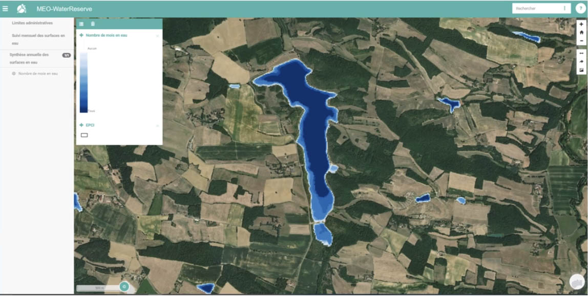
Demonstration of the WaterReserve service: the tool allows monthly monitoring or, as shown here, an annual summary of water surfaces. © MEOSS
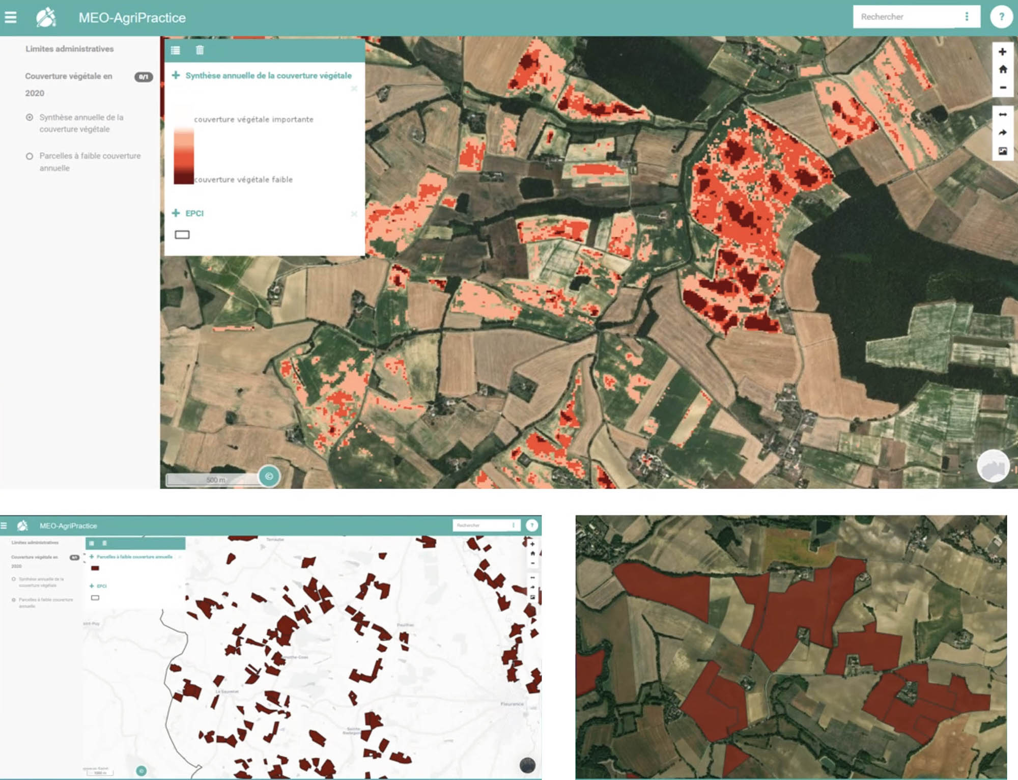
Indicator 2: AgriPractice for sustainable agricultural practices
It is now essential to preserve the vegetation cover between two crops because, even if minimal, it stores carbon and limits soil erosion. Delivering vegetation indices, AgriPractice is based on two bricks from Sentinel-2 optical data:
- Ground level coverage => available on the application, results are being analyzed;
- Natural barriers, including hedges: the IGN (french National Institute of Geographic and Forestry Information) has just delivered its data, which reinforces the detection part => the effort is now focused on the characterization of hedges.
Still in the evaluation phase, the first results show some inconsistencies that need to be addressed. The team is planning cross-analyses, notably with the rural calendar.
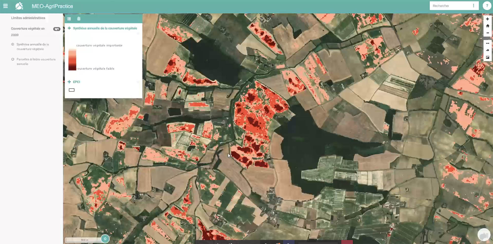
Demonstration of the AgriPractice service: annual summary of vegetation cover. © MEOSS
Indicator 3: GreenEnergy, to detect the potential of photovoltaic panels
Energy is the subject of intense debate within the territories. Indeed, if the latter are encouraged to produce energy, there is a lack of land, which the agricultural sector is reluctant to cede. The energy transition conferences, organized by the Chamber of Agriculture and the Gers Departmental Energy Union, will take place from October 2021 to initiate reflection, popularize information and have a common understanding on the subject of renewable energy production. Much further upstream than the initially proposed planning tool, the need is therefore not yet stable or clearly defined => Energy part pending, MEOSS will redefine the useful information of this indicator according to the results of the energy transition conference.
Conclusions
With the exception of GreenEnergy, the user requirements are consolidated and the developments and products are in the validation phase. Halfway through the project and in overall compliance with the schedule, the MEO-Climate project will use the next few months to develop the final services on the Web interface. And because SCO projects can also be a springboard for partner companies, the MEOSS start-up will be able to refine its business model. See you in 2022 for the final delivery!