

SCOFrance
Project partnersMEOSS
Gascony SCoT
CNES
Duration of trial12 months
KeywordsMEO Climate, SCoT, Gers, Gascony, MEOSS, PCAET (climate, air, energy, regional plan), PTER (centre for a territorial and rural balance), renewable energies, farming practices, water management
MEO Climate, official launch in the Gers region

A local project meeting national requirements
In 2019, France introduced a legal requirement for towns of over 20,000 inhabitants to set up their own PCAETs. To do this, the players concerned need diagnostic tools and resources to help them monitor the actions undertaken. “MEOSS is specially designed to address themes relating to the environment, climatology and climate change,” begins Thomas Ferrero. He tells us how he came to learn about the SCO: “'Connect by CNES' was already helping me to create my start-up, then CNES contacted me to tell me about the SCO. I submitted four applications for the first French call for projects. Of these, MEO Climate was selected and awarded the SCO label in March 2020”.
Seven months later, the project was launched in the greater Gers region in partnership with the collective association of municipalities for the local SCoT. Its chair, Hervé Lefebvre, points out that, “The SCoT is both a strategic document and a planning tool acting as the linchpin between regional and local entities. At the same time, the three PETRs of Auch, Armagnac and Portes de Gascogne are pursuing initiatives linked to the PCAETs. Close monitoring is required to make the PCAETs compatible and to link them up, so we can assess the effectiveness of the choices made and adjust them for greater efficiency. To this end, we felt it was necessary to develop new tools using satellite imagery to better explore climate change-related issues.”
On Monday, 16 November 2020, Thomas Ferrero and Hervé Lefebvre, respectively CEO of the MEOSS company and Chair of the Gascony SCoT officially launched the MEO Climate project. © MEOSS
MEO Climate, an operational tool addressing three themes
Based on its study entitled “The contribution of satellite imagery to PCAETs”, MEO Climate aims to meet three main needs: renewable energies, water management and farming practices.
- Photovoltaic energy
Given that local authorities need to set targets in terms of new power plants for energy production, MEO Climate will provide the Gascony SCoT with a tool capable of mapping existing facilities (detecting solar farms and solar panels wherever they are located) and then determining the most suitable locations for photovoltaic power plants (depending on sunshine, proximity of electricity poles, unused farmland, etc.).
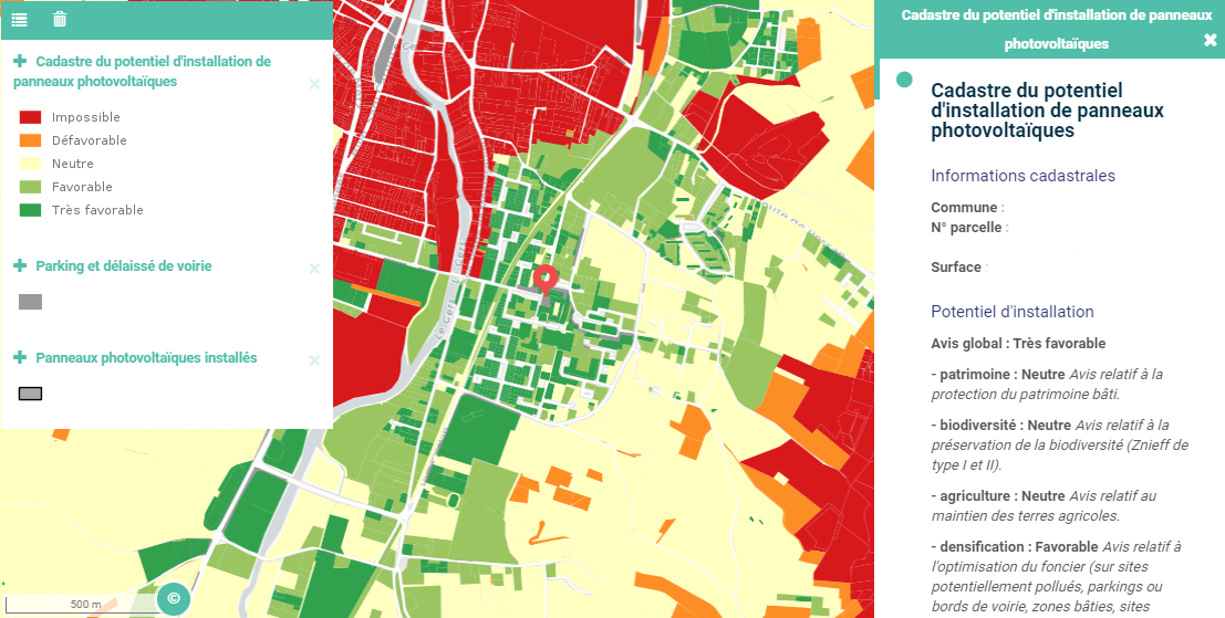
Mapping potential locations for photovoltaic installations © MEOSS
- Monitoring water reserves for agriculture
Through land-use mapping and 3D modelling, MEO Climate will enable a diagnosis to be made on how agricultural water is used and the reserves available.
- Changing agricultural practices
Given that leaving the ground bare between two crops favours soil erosion and that even minimal plant cover can store carbon, MEO Climate will use the repetitive imaging capability of the Sentinel satellites (Copernicus programme) to detect hedges and grassy strips in particular.
Satellite-based added value
In the light of the problems he encounters every day, the Chair of the Gascony SCoT has a well-founded opinion off the contribution of satellite observation to meet regional needs: “Satellite imagery ensures the homogeneity of data as well as their integration for regional mapping. With these recent and recurring data (at least one monthly image of the territory), we are able to monitor an area over time, but also to complete and cross-reference more “conventional” but often incomplete data. Combined with local data from geographic information systems, satellite imagery can be used to extract information with high added value information in order to respond to regional issues, particularly in terms of land-use and environmental planning”.
From trials to operational commissioning
As Thomas Ferrero explains, “We are going to work closely with the local and regional authorities, on an operational basis. The first step will be to set up a steering committee. This committee will include the SCoT of course, as well as elected representatives and PETR and PCAET directors, alongside local partners such as the Chamber of Agriculture and the electrification association, which has expertise in renewable energies. It may also be useful for departmental players to participate or receive information”.
The project allows one year for putting the tools in place, with the support of the SCO, then a further year to accompany users who will ultimately have access to two full years of analyses. “While local authorities need operational tools, they also need communication tools, for example to raise awareness among the farming community of the need for change. We have therefore designed our tools to deliver simple results, so that they can be used easily by local authorities and also shared with citizens” explains the MEOSS director.
SCO support
Having the idea for a tool is one thing, but developing and testing it is another. Thomas Ferrero is clear on this point: “In addition to providing financial support, which is particularly important for a small organisation such as ours, the CNES Lab'OT helps us to validate our technical studies. Having the label from the SCO, in this case represented by CNES, is a guarantee of reliability for locally elected representatives as well as for the technical players involved in the project.”
A viewpoint supported by Hervé Lefebvre: “It’s important to showcase the dynamic approach and capacity for innovation of our regions in order to highlight their appeal and vitality and also to raise their profile. As well as providing the trial with scientific validation from CNES, the SCO label also turns the spotlight on the Gers region as a whole. This contributed to the decision of local elected representatives to become part of the project.
When the tool is finalised, Thomas Ferrero is counting on the SCO to give him access to national authorities, such as the ministries making decisions on territorial coherence strategies, as well as to other countries facing the same problems.
Partners
- Founded in 2018, the start-up MEOSS (Maps Earth Observation Satellite Services) specialises in developing services based on satellite imagery and mapping data. It provides operational decision-support tools to manage and showcase local territories, specialised competence on climate issues.
- Founded in 2015, the collective association of municipalities overseeing the Gascony SCoT includes the Grand Auch Cœur de Gascogne urban community and 12 other groups formed by municipalities in the Gers department, making a total of 397 municipalities in all. Its mission is to implement the local SCoT, an inter-community framework document that articulates and ensures the overall coherence of all public policies (housing, transport, environment, economic development, etc.) within its area.