

SCOFrance
10Partners, including 6 Haitian entities
Useful linksGade Lapli project page
Key wordsHaiti, rain, flooding, COSPARIN, warning, crisis management, hydrometeorology, changing climate risks
Gade Lapli: top start in Haiti
Like any self-respecting and planned project, Gade Lapli is organised in Work Packages (WP).
Reminder: two main objectives
- Providing real-time assistance to Haitian civil security authorities, based on rainfall and flood zone estimation data from the COSPARIN (spatial contribution of spatial to flood risk analysis / COntribution du SPatial à l'Analyse du Risque INondation) project
- Creating indicators for monitoring and evaluating the evolution of climate risks from the point of view of extreme hydrometeorological events
WP 1000 : Management
Led by Predict Services with the support of CNES for the SCO, the consortium includes Météo-France, CEREMA, and six Haitian partners (Government of the Republic of Haiti, CNIGS, ONQEV, UHM, DGPC, LMI Caribact).
The role of the Haitian partners in making certain data available (particularly rainfall data, lidar DTMs, etc.) will be important from the start of the project in order to ensure that these data are adapted to the Haitian context. In a second phase, their feedback on experience and use will help consolidate the elements developed.
WP 2000: Adapting COSPARIN data to the Haitian context
Adapted to the Haitian context, COSPARIN data will be used to produce two types of indicators:
- real-time rainfall estimates (every 30 minutes) and associated rainfall totals;
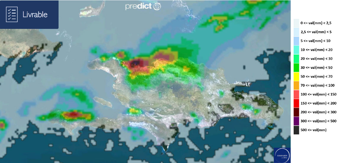
The COSPARIN rainfall estimate data for Haiti will be available for viewing every 30 minutes. The associated rainfall totals will be available at 1h, 3h, 6h, 12h, 24h, 48h and 72h.
- potential flooding areas, based on satellite DTM (Digital Terrain Model).
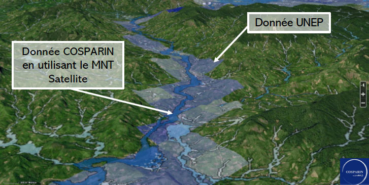
The accuracy of the satellite DTM reinforces the accuracy of the estimation of flood zones, based on the EXZECO model developed by CEREMA.
This information will be viewable at any time on an interactive web interface developed jointly with the AIBD/Egis project, notably on behalf of the Haitian Ministry of Agriculture (MARNDR). The platform will also offer an animation of rainfall over the last two hours, the security levels of each Haitian territory as well as risk information (location of risks and commentary specifying the dynamics of the phenomenon in progress).
WP 3000: Creation of indicators for monitoring and evaluating climate risks
There are four main stages in the creation of these indicators, which will be fed into a database within the web platform:
- Definition of input parameters for the characterisation of extreme events, thanks to a permanent watch by the Predict teams;
- Co-construction with Haitian experts of the method for producing the indicators;
- Production of indicators on each extreme event;
- Provision and monitoring of the evolution of indicators (frequency/intensity).
WP 4000 : Appropriation / restitution / capacity building
Created during the session at the request of the Haitian partners, this workstream will make it possible to identify and plan the milestones necessary for the transfer of knowledge to enable optimal use of the tool developed. Close links are also foreseen with the Haitian and Franco-Haitian academic community, especially in the framework of the LMI Caribact.
Work on the future governance of the platform and the data will be carried out throughout the project.