

GADE LAPLI

Project completedThe Gade Lapli project is aimed at crisis management stakeholders in Haiti, in particular the General Direction of Civil Protection (DGPC). It has made information on hydrometeorological risks available in real time via a 2D/3D web display platform and has enabled warnings to be sent out by email and SMS in relation to hydrometeorological phenomena at risk in the Republic of Haiti. The platform can be used to display data from the COSPARIN project, including:
✔︎ Precipitation estimates based on analysis of satellite images;
✔︎ Potentially flood-prone areas obtained using satellite DTM.
An interconnection has also been established with the haitidata platform, which centralises geospatial information in Haiti. Geographic information from this platform can be viewed on the Gade Lapli platform.
Overview
Thanks to the latest technological developments, particularly space-related, this project involves developing hydrometeorological crisis management tools and services. It uses satellite rainfall estimation data and potential flooding areas from the COSPARIN project (COntribution du SPatial à l'Analyse du Risque INondation) supported by CNES and ESA.
|
Tested in Haiti with the operational objective of adapting to climate change, the demonstrator provides local managers (General Directorion of Civil Protection, Hydrometeorological Unit, National Centre for Geospatial Information, National Observatory for Quality, Environment and Vulnerability) with a real-time assistance service for natural risks management. In this way, they can anticipate risk events and adopt effective measures according to the extent of the phenomenon. The second objective is to create indicators that will allow environmental and climate change assessment actors in Haiti to monitor the evolution of hydrometeorological events based on the number of extreme events and the evolution of precipitation (frequency, intensity). |
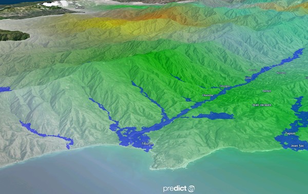
▲ Estimated rainfall and potential flood zone in Haiti (South department, west of the country) in the PREDICT Observer tools - result from COSPARIN |
Application site(s)
Haïti
DATA
Satellite data used as input to COSPARIN:
- weather satellites providing precipitation information
- geostationary: GOES, MSG, METEOSAT, FY, HIMAWARI
- polar: METOP
- Terra SAR-X and TanDEM-X satellites, allowing Airbus Defense and Space to produce DTMs (digital terrain models), used for estimating flood zones.
Information provided by COSPARIN
- Real-time precipitation with an accuracy of 5*5 km, available every 30 minutes to anticipate extreme events.
The precipitation estimation data is computed using several algorithms that correlate infrared satellite images (GOES, MSG, FY, HIMAWARI, METOP), microwave satellite data, cloud temperatures and precipitation rates. All data are integrated into a specific algorithm developed to estimate precipitation taking into account stratiform and convective cloud discrimination, precipitation estimation, seasonality, latitudes, evaporation correction, spatial variability estimation and orography adjustments.
- Flood zones modelled by a hydro-geomorphological method.
For Floodplain modeling, PREDICT Services uses data from Airbus Defense and Space, which provides a global digital terrain model (DTM) called WorldDem. The WorldDem data is very accurate and homogeneous over the world, with a vertical accuracy of 5 m (relative) / 10 m (absolute) in a 12 m x 12 m grid. These data are integrated into the CEREMA Exzeco model which is based exclusively on topography. This makes it possible to obtain potentially floodable areas on a large scale.
RESULTS - FINAL PRODUCTS
Real-time support for civil protection authorities
👉 👉Allows us to monitor the situation in Haiti, anticipate damaging events and support the various government users: the General Direction of Civil Protection (DGPC) and the Hydro-Meteorological Unit (UHM) at the Ministry of Agriculture (MARNDR). This product is materialized by the monitoring work carried out by PREDICT's Sémaphore center, which ultimately makes it possible to alert those involved in crisis management in Haiti (in particular the DGPC) as soon as a risk event is detected on the territory of the Republic of Haiti.
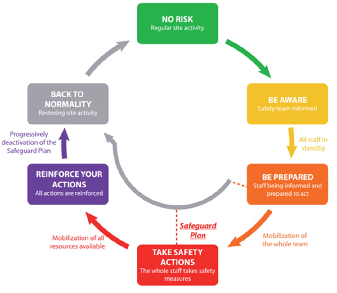 |
◀︎ Graduation of information sent by PREDICT Services according to the magnitude of the event. |
|
|
◀︎ Predict Services monitoring room. © Predict Services |

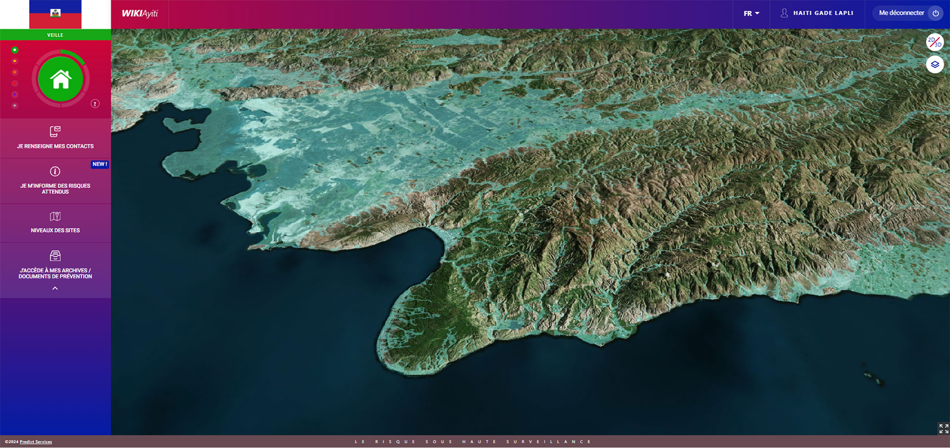
The GADE LAPLI platform
👉 Allows hydrometeorological phenomena to be visualized and guides risk managers in Haiti in the level of action to be taken. The platform includes data from the COSPARIN R&D project, which uses spatial data in its production process:
- Precipitation estimation data by analyzing satellite images, updated every 30 minutes and with a resolution of 5 km.
- Data on potentially flood-prone areas obtained from satellite Digital Terrain Models (DTMs).
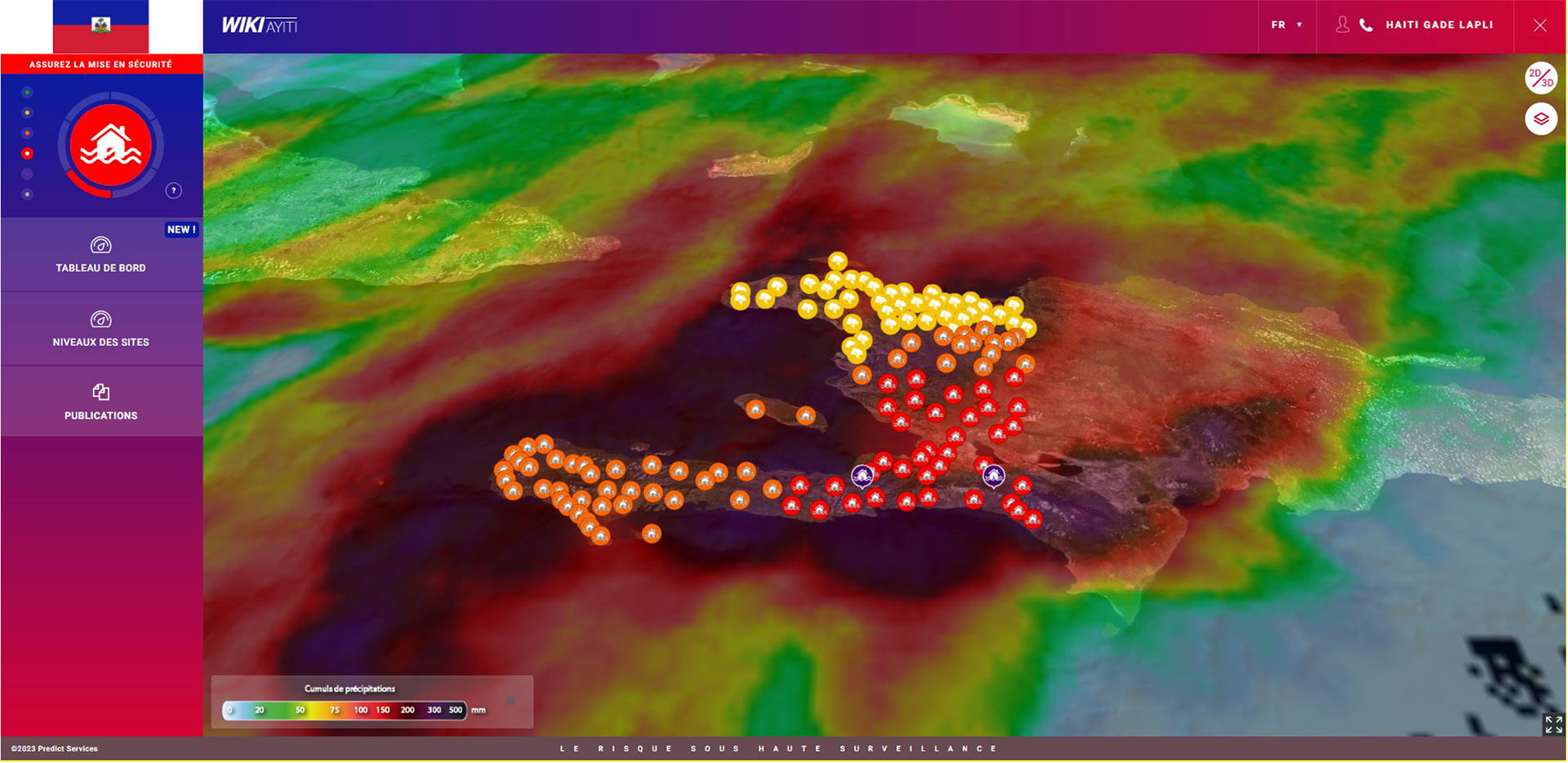 |
◀︎ Rainfall estimates and security warning levels for Haiti in the GADE LAPLI platform. © Predict Service |
|
|
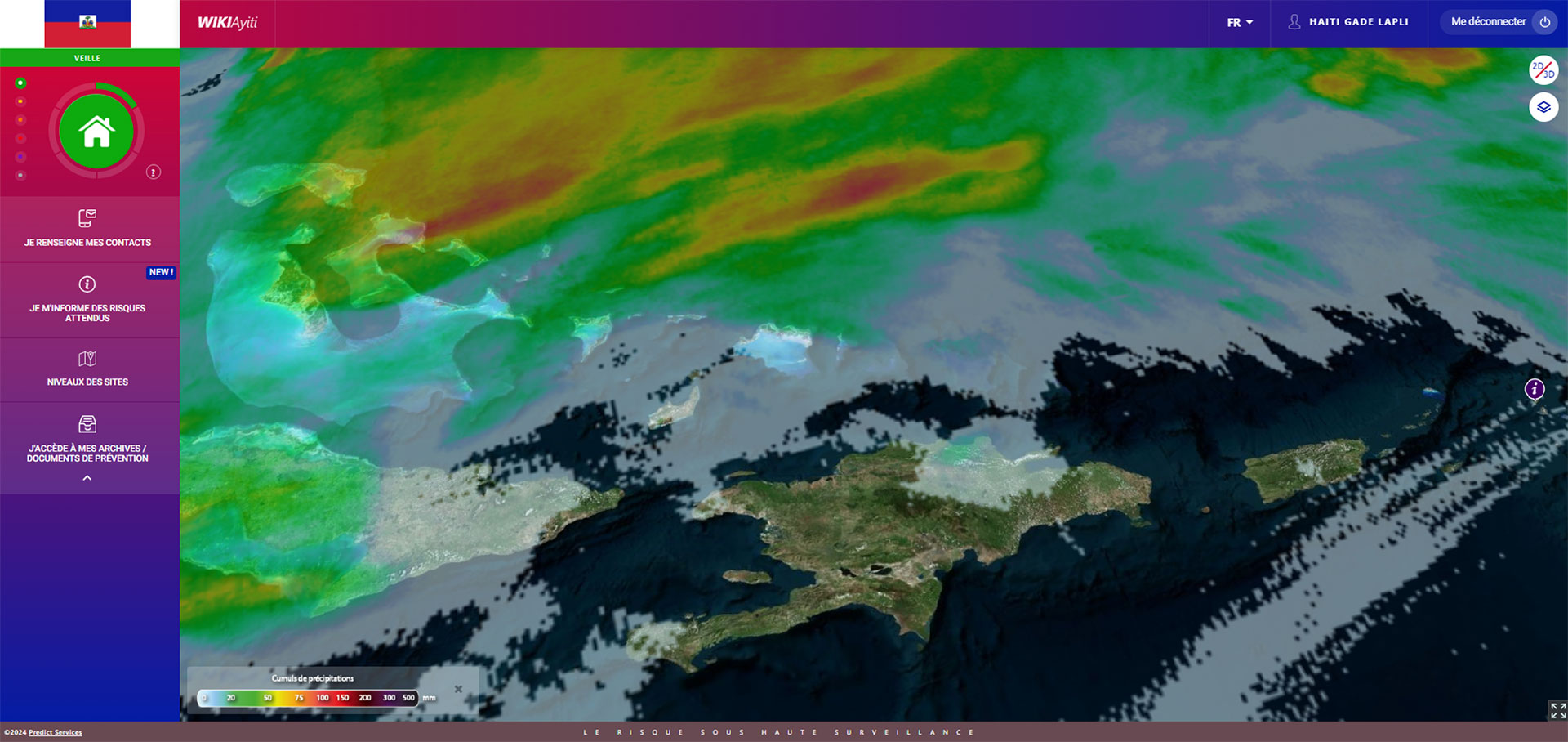
◀︎ Precipitation estimation data from satellite image analysis, GADE LAPLI platform. © Predict Service |
|
|
◀︎ Visualization in the GADE LAPLI platform of potentially flood-prone areas obtained from satellite DTMs. © Predict Service |
Creation of indicators for monitoring and measuring changes in climate changefrom the point of view of changes in extreme hydrometeorological events.
These indicators are directly linked to the 24/7 monitoring carried out by Sémaphore, which enables us to quantify:
- The number of events that occurred and their distribution over time.
- Maximum levels reached by territory.
- Types of risks that have occurred in Haiti.
- ...
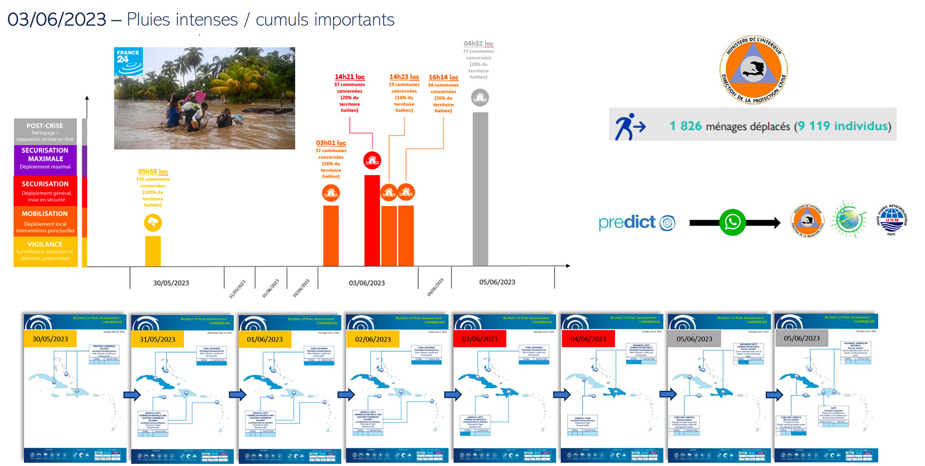
▲ Example of risk management assistance during the heavy rains at the beginning of June 2023, with daily bulletins and indicators issued as soon as the event was forecast at the end of May 2023 up to the post-crisis level, with an estimate of the damage. © Predict Services
|
|
◀︎ Hierarchical monitoring of extreme hydrometeorological events in Haiti. The orange colour calls for vigilance with local prevention measures, while the red level, implying very serious consequences, calls for action on a national scale. Purple calls for the mobilization of all available resources. © Predict Services |

Market place
 |
GADE LAPLI on GEO Knowledge Hub, a long lasting digital repository created by the Group on Earth Observations: https://gkhub.earthobservations.org/marketplace/items/czhht-set40 |
Project news
-
24/06/2024: Gade Lapli: early warning for everyone
-
21/12/2023: Final feedback meeting for the Gade Lapli project
-
02/12/2023: Presentation of the Gade Lapli project at COP28 on the French pavilion (round table entitled "Exploiting early warning systems based on Earth observations: from methane emissions to natural disasters").
-
29/03/2023: Presentation of the Gade Lapli project and its progress at the 8th Quarterly Meeting of the SCO France dedicated to SCOlutions to hydrometeorological risks, including an introduction on the use of satellite data in the different phases of risk management
-
15/02/2002 : Gade Lapli: top start in Haiti