

SCOFrance
PartnersACRI-ST, IUFRO, CNES
Pollutants factsheet
- NO₂, nitrogen dioxide
- O3, tropospheric ozone
- CO₂, carbon dioxide
- PM10 /PM2.5, coarse/fine particulate matter
Useful linksProject page
🎥 Presentation of GreenSpace at the 14th SCO France Quarterly Meeting
KeywordsAir quality, air pollutants, greening, ecosystem services
GreenSpace, satellites and science to help cities plant the right trees
A major public health issue, air pollution caused 4.1 million premature deaths worldwide in 2019. By 2050, when 70% of the world’s population will live in urban areas, this will amount to 6.6 million premature deaths. Compounding this problem is the intensification of urban heat islands as well as biodiversity loss.
🌳 In the face of these challenges, trees appear to be our best allies, particularly when it comes to removing air pollutants such as coarse particulate matter (PM₁₀), fine particulate matter (PM₂.₅), nitrogen dioxide (NO₂), ground-level ozone (O₃) and carbon dioxide (CO₂). However, it is important to note that their effectiveness depends on the species (some produce more ozone than they remove) and local climatic conditions.
Thanks to the work of the SCO GreenSpace project, cities now have a tool – the only one to our knowledge – capable of detecting, classifying and mapping individual trees (public and private) and green spaces at city level, and quantifying their ability to reduce (or not) air pollution and sequester CO2 at city level.
The GreenSpace solution
While ACRI-ST has finalized its solution for Bucharest (Romania) and Valencia (Spain) with the support of the SCO, work has begun on three other European cities: Aix-en-Provence (France), Florence (Italy) and Kaunas (Lithuania). Designed in close collaboration with the pilot municipalities, GreenSpace is now an operational tool. By cross-referencing satellite data, field data and scientific data, it is capable of:
-
Detect and map individual trees, thereby providing a comprehensive inventory of public and private urban tree heritage, bearing in mind that on average 80% of this is privately owned.
-
Identify species based on textural characteristics - true satellite signatures - and estimate the height of each tree.
-
Realistically quantify each tree’s capacity to remove (or not) atmospheric pollutants.
-
Provide scientifically based recommendations on the best plant species suited to the local context. These take into account co-factors such as allergenic pollen emissions or disease resistance.
👉 These findings help to design and implement ambitious greening strategies that comply with guidelines such as the Territorial Climate, Air and Energy Plans in France, or the European Union’s Biodiversity Strategy for 2030 and the Nature Restoration Regulation 2024. They also provide valuable support for the maintenance of urban tree populations.
What does GreenSpace say about Bucharest and Valencia?
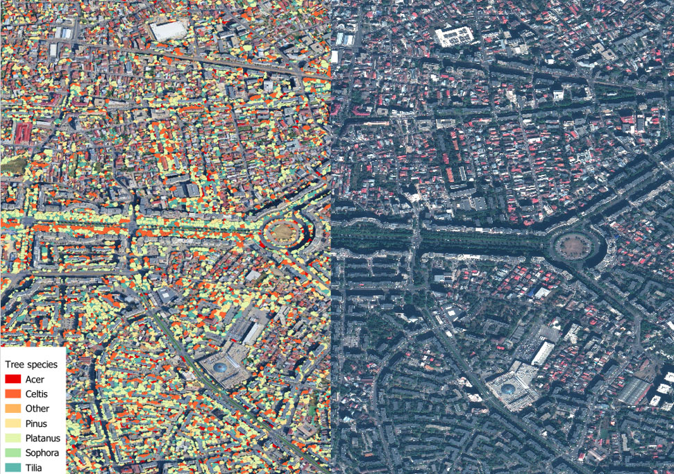
- In Bucharest, where lime and maple trees dominate in a continental climate, the 370,866 mature trees recorded across four districts of the city removed in 2024: 236 tones of O₃, 171 tones of NO₂, and 94 tones of PM₁₀. A total of 1,595,031 trees were detected across the municipality (350 km²).
|
► Location of public and private tree canopies in south-west Bucharest based on a Pleiades image acquired in 2024. © Airbus DS, Traitement ACRI-ST |
|
|
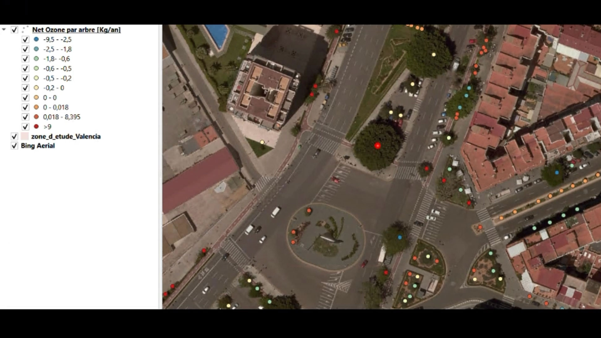
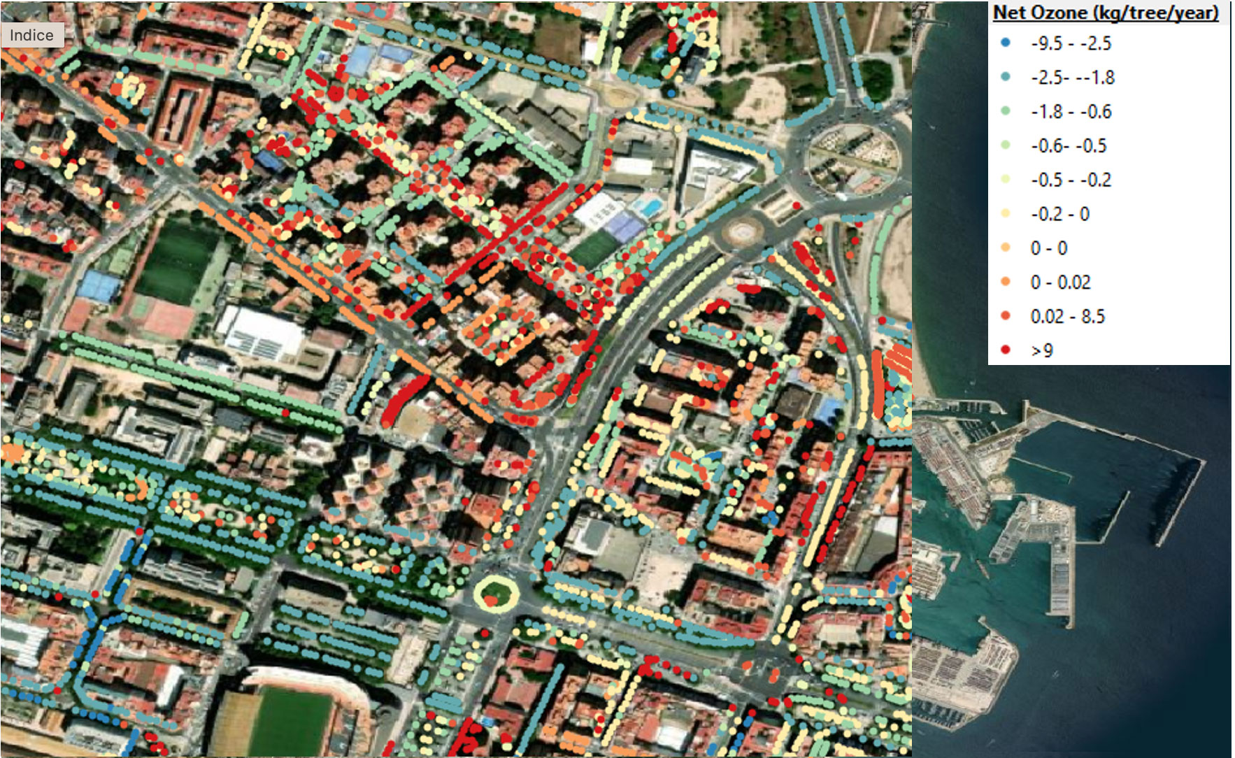
🚘 In Valencia, the amount of pollutants removed offset the emissions of around 106,000 cars. Find out more: GreenSpace unveils initial results for Valencia
|
|
► Focus on Valence. Each colored dot indicates a tree’s ozone-removal capacity, with orange to red tones indicating those that promote ozone formation. © Airbus DS, Traitement ACRI-ST |
|
🌴 With its abundance of palm trees, the French city of Nice faces the same problem. Looking ahead, some species recommended for Valencia are also suitable for south-eastern France, which is set to have a climate similar to Valencia’s by 2050.
👉 Increasing tree cover to 30% in Bucharest and Valencia could prevent 508 premature deaths attributed to air pollution each year.
🖱️ View the detailed results and final report on the project page
Outlook
While several European cities have already expressed interest in GreenSpace, the city of Madrid wishes to use this platform to report on the health of trees (via defoliation/discoloration indicators) and fire risk (determined by the flammability of trees based on canopy water content and weather criteria such as temperature and wind).
|
The ACRI-ST team is already working on various improvements and new features, including:
|
The 3-30-300 rule Every citizen must . be able to see at least three trees from their home, workplace or school, . live in a neighbourhood with more than 30% tree cover, . live within 300 metres of a green space with trees. |
Interested in using GreenSpace in your town? Contact ACRI-ST here!