

GreenSpace
Satellite mapping of green spaces for green and healthy cities
Project completedImplemented in five European cities, the GreenSpace service combines satellite and scientific data to create a comprehensive inventory of public and urban tree populations, realistically quantify the removal of key air pollutants and greenhouse gases by these trees, and provide recommendations on the best species to plant. It thus enables cities with at least 20,000 residents to develop ambitious greening plans in response to environmental guidelines.
Overview
|
Against a backdrop of climate change, air pollution, rising greenhouse gas emissions and urban heat islands are major issues affecting citizens’ quality of life and well-being, as well as biodiversity in general. |
In 2022, 73% of the European Union’s population lives in cities. Air pollution causes nearly 500,000 premature deaths per year, and 62,000 deaths due to heatwaves. |
Urban trees are a key lever, provided the right species are chosen and their benefits are objectively quantified. Achieving 30% tree cover in the 744 European cities with over 50,000 inhabitants could prevent nearly 12,000 premature deaths each year (Sicard et al., 2025).
Environmental policies, such as the European Union’s Biodiversity Strategy (COM(2020) 380), the Pollinators Strategy (COM(2021) 261), and the Nature Restoration Regulation (Regulation (EU) 2024/1991) require towns and cities with at least 20,000 inhabitants to:
- Develop an ‘ambitious urban greening plan’.
- Ensure that there is no net loss of urban green spaces and tree cover by the end of 2030.
- Increase the total area of urban green spaces, with monitoring every six years from 1 January 2031.
Consequently, municipalities with more than 20,000 inhabitants, and local authorities, require a concrete, realistic and quantified assessment of the capacity to remove air pollution and greenhouse gases. However, municipal inventories account for only 10 to 20% of the tree stok, i.e. trees managed by the municipality, while the remainder are on private property, where counting is only possible via remote sensing.
GreenSpace therefore proposes:
#1 – A complete inventory of the tree stock
By analyzing very high-resolution satellite images and a geographic information system (GIS), our approach enables us to detect, delimit, count, classify and map tree species to provide a complete inventory of both private and public trees. Since 2000, the spatial resolution of very high-resolution optical satellite sensors has made it possible to detect, classify and map tree attributes at a fine scale and at a lower cost compared to field surveys or airborne laser scanning.
🛰️ We use the spectral and textural characteristics of Pleiades and WorldView-2 imagery (with ground spatial resolutions of approximately 0.5 and 0.3 m, respectively, in panchromatic mode) to classify trees by dominant species. The counting methodology has been tested (Araminienė et al., 2023; Sicard et al., 2023; Lopez et al., 2025).
👉 This complete inventory makes it possible to realistically quantify the services provided by trees in order to quantify the elimination of the main air pollutants and greenhouse gases by urban trees.
#2 – An estimate of the environmental benefits of the tree stock
Vegetation facilitates the deposition of particles (PM2.5, PM10) and gases on the plant surface, and absorbs gaseous air pollutants (CO2, NO2 and O3) through the stomata, resulting in an effective long-term improvement in air quality across the city. To reduce pollution effectively, municipalities need a realistic assessment of the role of trees in air quality.
🛰️ Using tri-stereoscopic satellite image analysis, we obtain precise data for each tree on its structural characteristics (e.g. tree height), which are essential for quantifying carbon storage capacity.
⚙️ For each tree, we have calculated the amount of particulate and gaseous pollutants deposited on the branches, leaves/needles and trunk, and the amount of gaseous pollutants removed by absorption through the stomata. At the same time, plants emit volatile organic compounds that lead to the formation of secondary pollutants such as O3. We distinguish between removal and formation.
👉 On the basis of a complete inventory (number, location, species) of the public and private tree population at the municipal level, we quantified (in tons per year) the capacity of the public and private tree population to remove the main pollutants (NO2, O3, PM2.5, PM10) and to sequester greenhouse gases (CO2 and O3).
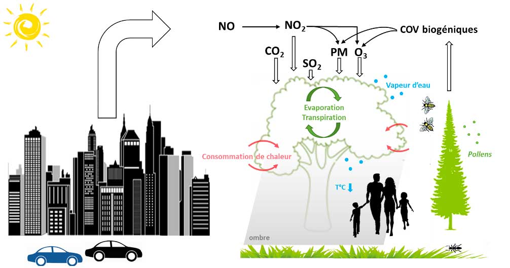
▲ Interactions between anthropogenic pollutant emissions, air pollution, green spaces, biodiversity and public well-being. © ACRI-ST
#3 – Recommendations for healthier air: Planting the right species in the right place
Which plant species are best suited to improving air quality and sequestering carbon, and which should be avoided? GreenSpace offers a guide of recommendations for implementing a planting policy with a list of appropriate species to plant for healthier air, enabling compliance with the forthcoming COM(2020)380 regulation, which requires cities with at least 20,000 inhabitants to develop an ambitious urban greening plan.
When selecting species, in addition to their potential for removing air pollutants, we consider factors such as allergenic pollen emissions, attractiveness to pollinators, disease resistance, etc.
Application site(s)
|
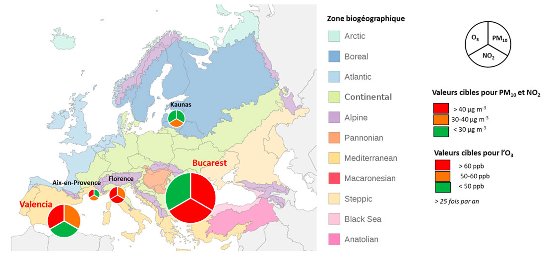
GreenSpace is the fruit of a dozen years of preparatory scientific work. An initial demonstrator of GreenSpace services has been deployed in 3 European cities (Aix-en-Provence, Florence and Kaunas). Here we move on to the prototyping phase, considering the needs to be modulated according to the type of urban habitat, climatic conditions and the specific needs of local authorities. To overcome these problems, the services will be fully prototyped in 2 additional cities:
|
▲ Location of cities where SCO GreenSpace services have been deployed, based on air pollution levels in 2022. © ACRI-ST |
Données
Satellite
- Pleiades
- WorldView-2
Other
- Municipal inventories of public trees
- DTM
- Hourly weather and air quality data
- Physiological characteristics of trees
Results – Final product(s)
GreenSpace has provided local authorities with the information needed to comply with new laws and regulations linked to the European Green Deal, as well as guidelines for an appropriate greening strategy.
The end products are:
#1 – A complete inventory of the tree stock
#2 – An estimate of the environmental benefits of this tree stock
#3 – Recommendations for healthier air
👉 The final report (in French) is available in the Resources section below.
Valencia
- Study area centered on the city center (56 km², 41.2% of the city’s total area).
- 284,305 trees identified, overall accuracy ≈ 88% (orange trees, plane trees, lime trees, palm trees).
- Within the study area, the 284,305 trees removed in 2022: 197 tones of NO₂, 37 tones of PM₁₀, 5,430 tones of CO₂
- The current tree population produced more O₃ than it removed (formation: 336 tones, removal: 111 tones), mainly due to the high ozone-forming potential of palm trees.
=> Some species generate more ozone than they remove, highlighting the importance of species selection.
|
|
|
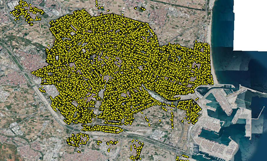
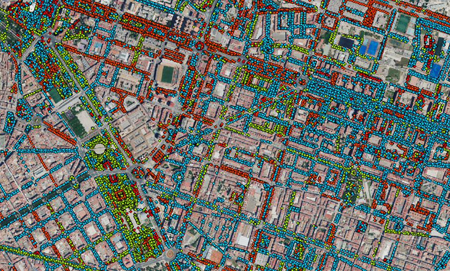
▲ Location of the 146,445 trees in public and private areas of Valencia in 2022. Each plant species is identified by an ID and a color code. © ACRI-ST
The explorer allows users to view maps of tree cover and to overlay these maps with other information relating to the urban context (road network, etc.) or to display the very high-resolution satellite image used for detection, as well as the canopy height model. A panel appears on the right when you click on a tree to view detailed information: tree ID, plant species, location (latitude, longitude), height, and its pollutant removal capacity.
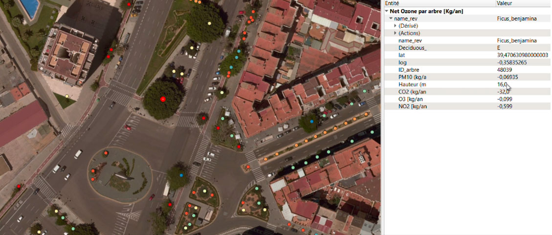
▲ The explorer allows users to view tree cover as well as the attributes of each public and private tree. © ACRI-ST
Bucharest
- City-wide estimate: ~ 1.6 million trees (plane trees, ash trees, lime trees, oak trees).
- Within the study area, the 370,866 mature trees removed 171 tones of NO₂, 94 tones of PM₁₀ and 236 tones of O₃ in 2024.
In addition, knowledge was transferred to urban planners and local stakeholders: the results were prepared in collaboration with local stakeholders and delivered in a format compatible with the GIS systems of the technical departments of both municipalities. Public awareness campaigns were used to inform owners of private land about maintenance rules and best practices.
|
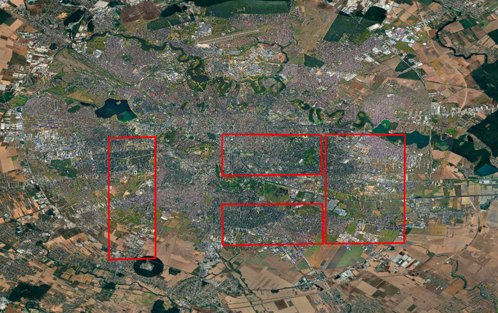
► The four study areas in Bucharest (67 km² out of 350 km²). Pleiades satellite image acquired on 23 September 2024. © Airbus DS |
|
|
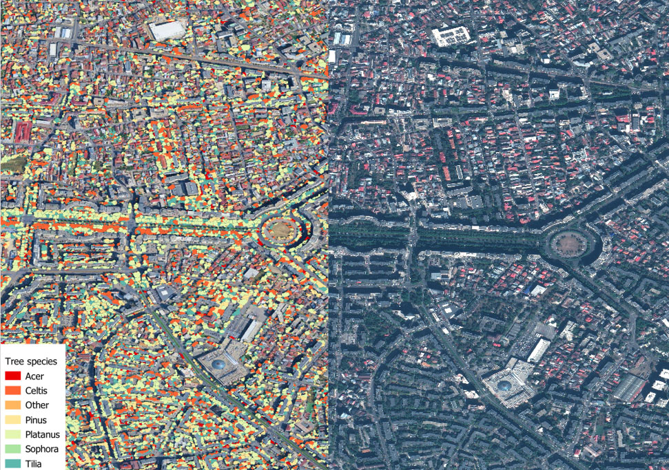
► Location of tree canopies in public and private areas of Bucharest in 2024 (zoom on an area in south-west Bucharest). Each plant species is identified by an ID and a color code. © Airbus DS/Treatment ACRI-ST |
|
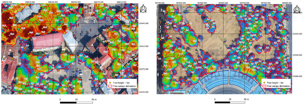
▲ Detection and estimation of tree height in a study area in Bucharest. © ACRI-ST
User feedback
Results achieved through co-design with the municipality, meeting operational needs.
- Comprehensive and reliable overview of the tree stock.
- Simple and intuitive interface for visualization.
- Tool to assist with urban planning and maintenance.
- Selection of suitable plant species.
- Support for environmental policies and securing funding.
References
-
Sicard P., Coulibaly F., Lameiro M., Araminiene V., De Marco A., et al., 2023, “Detection and Classification of Urban Trees from Very High-Resolution Satellite Imagery”. Urban Forestry & Urban Greening 81: 127866. https://doi.org/10.1016/j.ufug.2023.127866
-
Sicard P., Agathokleous E., Anenberg S.C., De Marco A., Paoletti E., Calatayud V., 2023, “Trends in urban air pollution over the last two decades: A global perspective”. Science of the Total Environment 858: 160064. https://doi.org/10.1016/j.scitotenv.2022.160064
-
Estimation of air pollution removal capacity by urban vegetation from very high-resolution satellite images in Lithuania https://doi.org/10.1016/j.uclim.2023.101594
-
Effect of tree canopy cover on air pollution-related mortality in European cities: an integrated approach https://doi.org/10.1016/S2542-5196(25)00112-3
-
The 3–30–300 rule Compliance: A geospatial tool for urban planning. https://doi.org/10.1016/j.landurbplan.2025.105396
Related projects
SCO Projects
Other
- The AIRFRESH project “Air pollution removal by urban forests for a better human well-being”, funded by the European LIFE 2019 programme.
Project news
-
24/03/2026: GreenSpace, satellites and science to help cities plant the right trees
-
20/03/2025: Presentation of the GreenSpace solution at the 3rd SCO France Congress in Paris
-
12/12/2024: GreenSpace unveils first results for Valence study case
-
23/09/2024: Presentation of the GreenSpace project and its progress at the 14th SCO France Quarterly Meeting "Monitoring air quality from space"
-
12/02/2024: GreenSpace: choose carefully trees species