

Green Urban Sat

An observatory for urban vegetation
Project completedAimed at local authorities and other local decision-makers, the Landia platform (Green City) containing detailed mapping of urban vegetation in Greater Nancy and associated indicators is now available. The platform allows users to view and interact with the proposed indicators. It contains a number of tabs: summary indicators at different mesh sizes (hexagonal, urban morphological island, IRIS, communes, etc.), data explorers and summary dashboards.
OVERVIEW
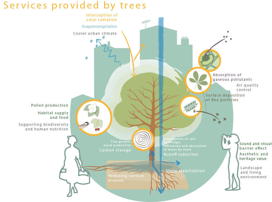
Today, actors of territory arrangement face different challenges such as climate change adaptation, biodiversity preservation, energetic efficiency and sobriety, maintaining a comfortable and healthy living environment for the inhabitants. In highly urbanized zones, it is admitted that integration and preservation of nature-based solutions (NBS) constitute an essential lever to meet these stakes. These work, systems or natural areas are often characterized by a vegetal component and contribute to the resilience of cities, in terms of attenuating heat islands or rending pervious again the soil to limit floods (whose frequency will be radically increased at 2100 horizon).
|
The benefits that can be drawn from NBS are qualified as ecosystem services (ES) and are surveyed by the scientific community. It is admitted that the existing tools to evaluate those ES on a given area, with an integrated multi-criteria vision, are not mature enough for operational applications, in particular for small spatial units and for complex and heterogeneous environments such as urban areas. Green Urban Sat endeavors to compensate for this shortcoming. The project “Des Hommes et Des Arbres” (“Humans and Trees”) and Nature4Cities constitute the conceptual and thematic frame of Green Urban Sat. |
© Cerema, translated by SCO |
Green Urban Sat produces a fine description of vegetation at conurbation scale. This description provides a set of quantitative attributes and indicators that will allow to feed a group of decision aid tool indicators that are supported by ecosystem services : climate regulation, air quality regulation, contribution to ecologic continuities, socio-cultural benefits.
The partners of this project form a pluri-disciplinary team able to handle with all the tasks necessary to the achievement of the project. The skills include scientific aspects relative to urban remote sensing, nature-based solutions and ecosystem services knowledge, the capacity of producing and implementing methodologies based on imagery and industrialization of the process. The final users who have expressed the terrain need were heavily involved in the project.
Methodology
A classification of (peri-urban) vegetation shapes has been produced, as well as morphological and structural 2D and 3D indicators, suited to the vegetation typologies corresponding to the description of the settlement and configuration of different shapes of vegetation.
This classification and the indicators derived from it are based on Pleiades multi-temporal and stereoscopic imagery and the associated 3D products.
The vegetation is first extracted by supervised classification (artificial intelligence algorithms), then the vertical strata (herbaceous, shrubby and arborescent) are calculated from the image texture and the height derived from the Pleiades digital surface model (3D model). The plant forms (isolated individual, alignment, afforestation) are then determined using spatial analysis and image processing algorithms. The frame of reference then cross-references the vegetation description obtained with the surrounding landscape, deduced from the Local Climate Zones (LCZ) classification*, enabling the ecosystem services provided to be described more accurately. Finally, descriptive attributes (indicators describing plant morphology, plant cover, the soil supporting the vegetation and the landscape) are calculated on the plant forms and provided in the final geospatial layer.
* from LCZ mapping developed by the SCO SatLCZ project in Nancy
Application site(s)
- Nancy : main partner of experimentation
- Strasbourg : area of replicability tests
DATA
Pléiades and Pléiades Neo images and associated 3D models
RESULTS - Final products
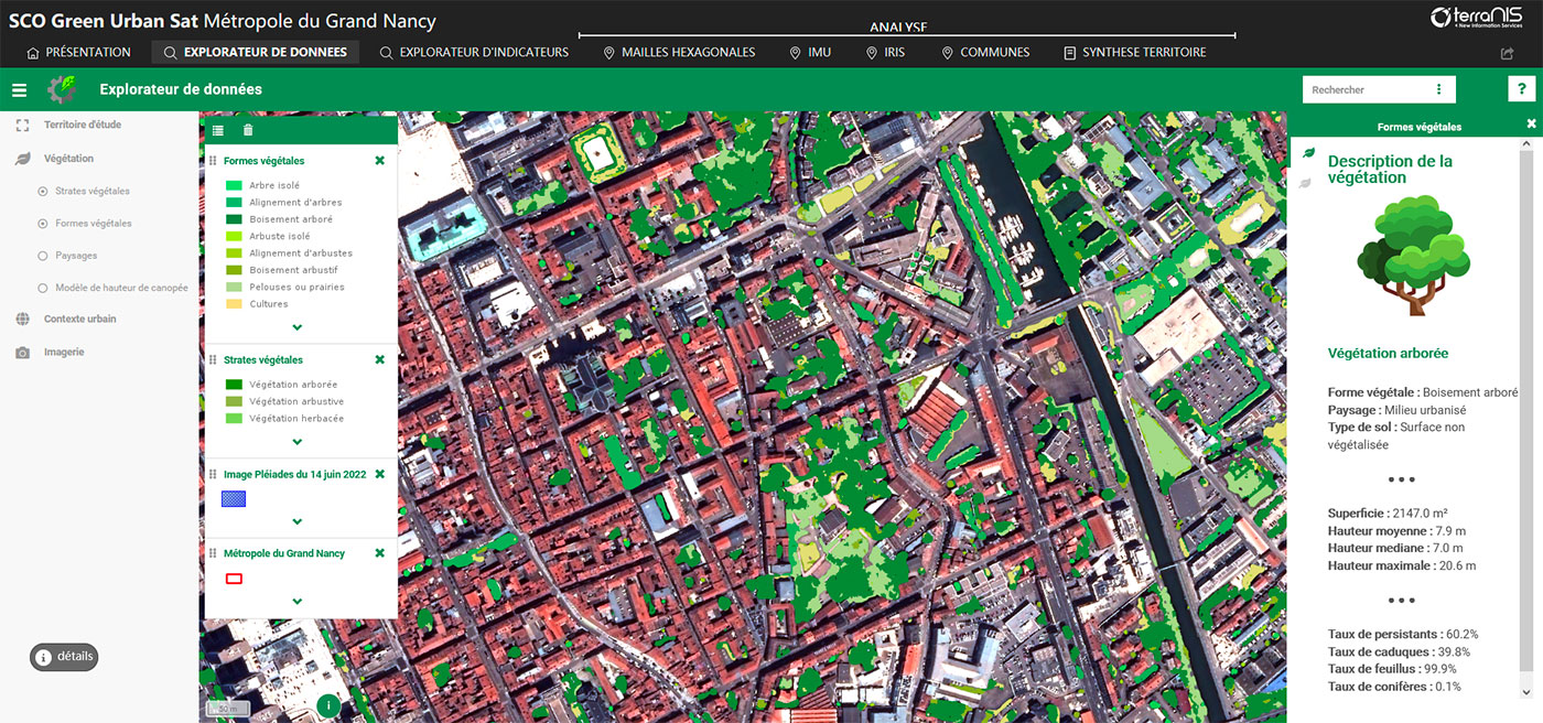
Landia online interface, whose demonstrator with the final vegetation layer and associated indicators for Greater Nancy is freely available
|
In the map explorer, users can choose to display all or some of the different masks (vegetation strata, plant forms, landscapes, land use, canopy height, LCZ local climate zones). |
Screenshot of the data explorer with the final Green Urban Sat layer for Greater Nancy. © TerraNIS |
|
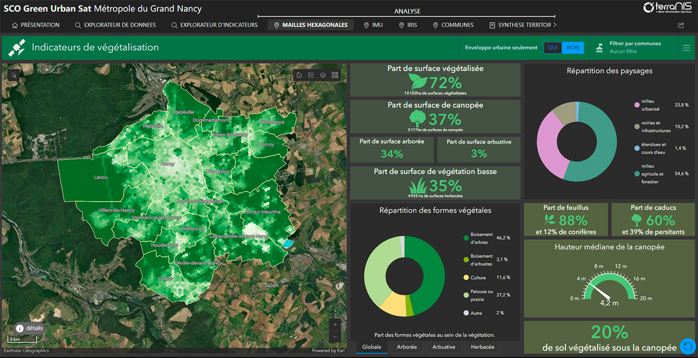
In addition, the tool generates a dashboard summarising information at different scales. |
Screenshot of the summary for the Greater Nancy area. © TerraNIS |
Testing the demonstrator in the Greater Nancy area
Algorithmic codes available on Cerema's Github
Summary report
Available to download in the Resources section below, this report (in French) details the project, the methodology used and the development of data and indicator display interfaces.
🛠️ For any questions about the methodology, contact Cerema.
👁️ For more information on the platform or a demonstration, contact Terranis.
Perspectives
While the demonstrator is already being used by the Metropole of Greater Nancy, which wants to carry out a multi-scale diagnosis of its plant heritage, work will continue on the Des Hommes et des Arbres project to strengthen the tool in terms of the ecosystem services provided by vegetation. The GUS team also hopes to develop an optimised V2 that can be more easily replicated in other regions.
Market place
 |
Green Urban Sat on GEO Knowledge Hub, a long lasting digital repository created by the Group on Earth Observations: https://gkhub.earthobservations.org/marketplace/items/62g65-qq533 |
Related SCO projects
Project news
- 04/04/2024: GUS, an urban vegetation observatory: delivery of the demonstrator
- 24/05/2023: GUS, mid-term review
- 20/04/2023: Cerema's satellite unit tests the use of new Pleiades Neo images to improve the mapping of urban vegetation (in French)
- 16/03/2023: GUS presentation at the FERED forum (French federation of research in environment and sustainability)
- 16/03/2023: Presentation at the Digital Event Challenge Pleiades Neo
- 02/02/2023: Presentation at the Remote Sensing for the Study of the Urban Environment workshop of the Theia cluster
- 29/11/2022: Poster for the lab/company day
- 13/07/2022: 🎥 Presentation of the Green Urban Sat project and its progress at the 5th Quarterly Meeting of the SCO France on the theme "Pleiades data in SCO projects"
- 12/08/2021: Using satellite imagery to finely characterize vegetated forms: the Green urban Sat project (Cerema article, in French)