

IRRISAT-MAROC

Project completedThe IRRISAT-MOROCCO project has made it possible to operationalize the production of information and indicators on irrigation water at plot level via the SAT'IRR platform, and at watershed and irrigated perimeter levels via the IRRISAT interface. Products at the global scale were supplied to the project partners Regional Agricultural Development Office (ORMVAG), Sebou Water Basin Agency (ABHS) and National Institute for Agronomic Research, Kénitra (INRA-Kénitra). The SAT'IRR platform has been set up at the CRTS and will initially be used to distribute advice to ten or so farmers in the Gharb and Haouz regions.
Overview
In Morocco, water management is vital because the climatic and hydrological context is extremely fragile. Climate change, through increasingly recurrent extreme events of drought and flooding, and the pressure of growing demand are all factors that make it necessary to plan development and water resources management strategies. Morocco thus began the first water resources planning studies in the 1970s.
Today, the Ministry of Equipment, Transport, Logistics and Water has set up a drinking water supply and irrigation program for the period 2020-2027, with a budget of 115.4 billion dirhams (10.7 billion euros). In addition to increasing the availability of water through the construction of 20 new dams and the desalination of sea water, an important axis of this program concerns the continuation of the modernization of irrigation networks, the collective conversion to localized irrigation as well as the realization of irrigation water saving through the use of New Information Technologies.
In this context, we wanted to bring two research projects into synergy: IRRISAT Morocco, initiated by CRTS in 2015 on the Tadla irrigated perimeter, and SAT'IRR, initiated by CESBIO (France) in collaboration with Caddi Ayad University in Marrakech, on the Haouz irrigated perimeter. These 2 projects have already provided local irrigation managers and farmers with a decision-making support system for water saving and productivity, based on Earth observation techniques.
Two complementary approaches
- IRRISAT is based mainly on space observations in the thermal infrared range
|
As part of an earlier project on the Tadla irrigated perimeter, IRRISAT is using the SEBAL model to estimate evapotranspiration (actual, potential and reference), biomass and soil moisture, and to produce indicators of irrigation water consumption, requirements and productivity. An online platform has been developed to make this information available to the Regional office of agricultural development of Tadla (ORMVAT), farmers in the region and the Oum Rbaii Water Basin Agency (ABHOER). |
▲ IRRISAT generates its products at a frequency of 16 days at 30m resolution with Landsat data, and at a daily frequency at 100m resolution using PROBA-V and NPP-VIIRS data. © IRRISAT |
- SAT'IRR is based on water balances
The SAT'IRR (Satellite for Irrigation Scheduling) methodology uses the FAO method56 to calculate a daily water balance at the user plot scale. Space observations (Sentinel-2, Landsat-8) are used to characterize crop development. A water balance is calculated by comparing the crop development predicted from meteorological and satellite data with the optimal development of these crops. The objective is to predict the date and quantity of the next irrigation with about four days’ notice. The software, developed from purely open-source resources, has been designed to be computationally and storage efficient so that it can run on a small server. The SAT'IRR platform has already been tested in several countries (Spain, France, Morocco, Tunisia, Lebanon) without any technical or practical problems, and its web interface is aimed at farmers.
Application site(s)
Morocco:
- Gharb irrigated region
- Tensift hydraulic basin
- Sebou hydraulic basin
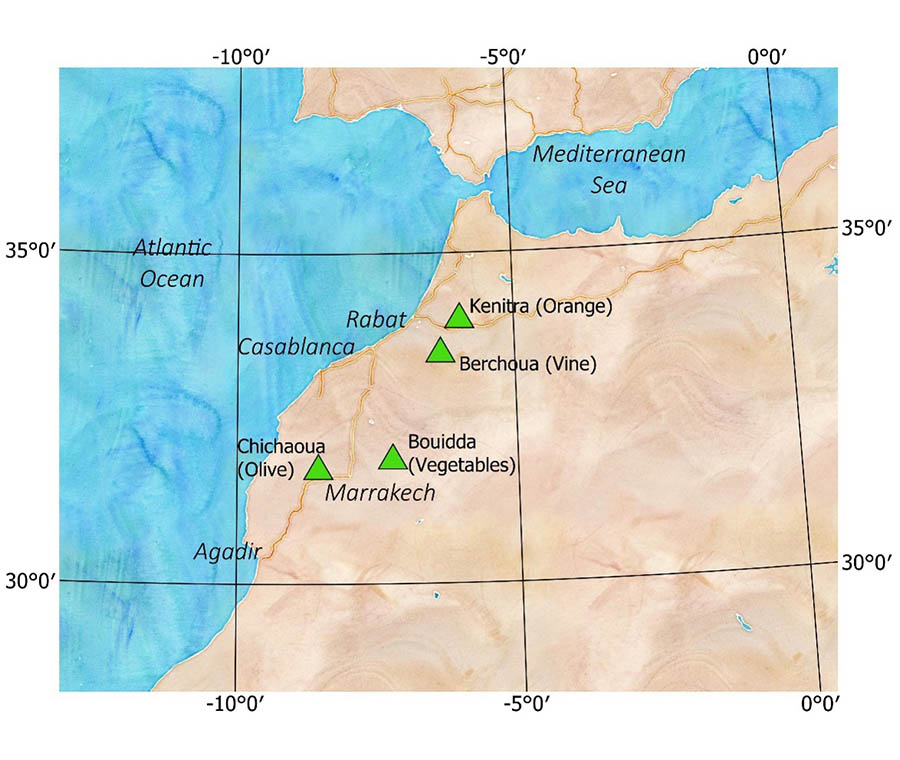 |
◀︎ Three experimental sites have been specifically deployed as part of SCO IRRISAT, thanks to additional funding from CRTS and the ERANETMED CHAAMS project. One in the Haouz plain near Marrakech, two in the Bouregreg watershed, about an hour from Rabat. The sites were chosen for their diversity of crops, with annual crops to the east of Marrakech, and a vineyard and orange orchard near Rabat. We were also able to draw on the support of the TREMA International Joint Laboratory to use and complement the experimental olive site to the west of Marrakech. |
The Kénitra and Chichaoua sites are equipped with an eddy-covariance system for measuring evapotranspiration flux. The Berchoua (vineyard) and Bouidda sites are equipped with lighter devices (IRT, soil moisture, irrigation meter). All these data, measured on an hourly time step, are transmitted daily to the server. After the end of the IRRISAT-MOROCCO project, the systems at Kénitra, Chichaoua and Berchoua will remain in place.
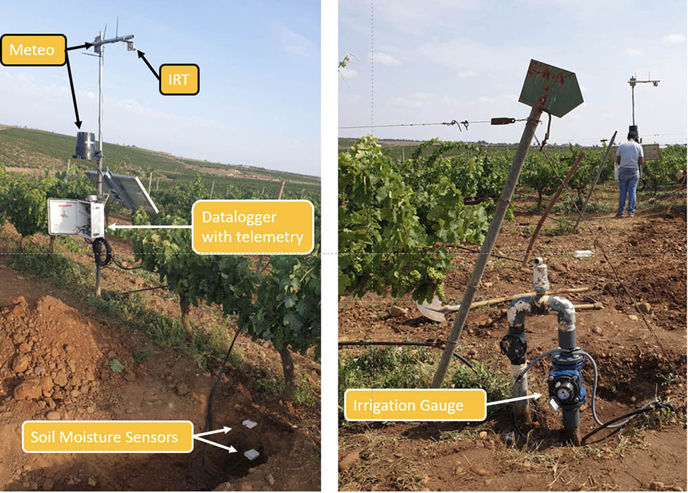
▲ Instruments deployed at the Berchoua site: a weather station (P, T°, Hr), an IRT (Surface Temperature), an irrigation meter and two soil moisture sensors. © CRTS |
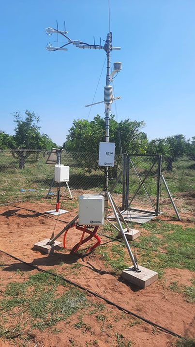
▲ Eddy-covariance system deployed on the Kénitra orange orchard. © CRTS |
DATA
Optical Satellites
- VIIRS, resolution 375 m
- Landsat, resolution30 m
- Sentinel-2, resolution10 m
- Mohammed VI A and B, resolution ~ 2 m
Radar satellites
- Sentinel-1, resolution10 m
Other
- Meteorological data
. Station data: daily rainfall, hourly air temperature, hourly relative humidity, hourly wind speed at 2m, solar radiation
. 1km grid data: Land Information System (LIS) assimilation data, LANDSAF solar radiation
- Field data
. Soil moisture measurements
. Weather and irrigation measurements
. Measurement of evapotranspiration fluxes using the Eddy-Covariance system
. Land use surveys
Methodology implemented
To ensure the sustainability of the results and move on to the operational phase, a number of preparatory actions were carried out.
- A market study of satellite irrigation assistance at global and Moroccan level
Our investigation of the two existing markets for remote sensing applied to agriculture and irrigation equipment shows that they are sometimes merged into a single one, called precision agriculture. Countries with intensive agriculture are interested in irrigation control, but outside semi-arid regions, the main motivations are savings in labor and/or energy (used during an irrigation cycle), before rational management of water resources. Market studies indicate that the irrigation control market offers interesting prospects, given demand and growth potential, but that market size is small. There therefore seems to be a convergence towards integrated farm management systems that can integrate services such as equipment and irrigation control services. The main suppliers of irrigation decision-support solutions are often equipment manufacturers or agricultural suppliers. However, as indicated by the USDA Census of Agriculture 1998-2018, the use of these tools is still rare.
We also carried out an open interview survey with 15 farmers in the Haouz region of Marrakech. Despite the narrowness of the panel, this enabled us to draw some preliminary conclusions.
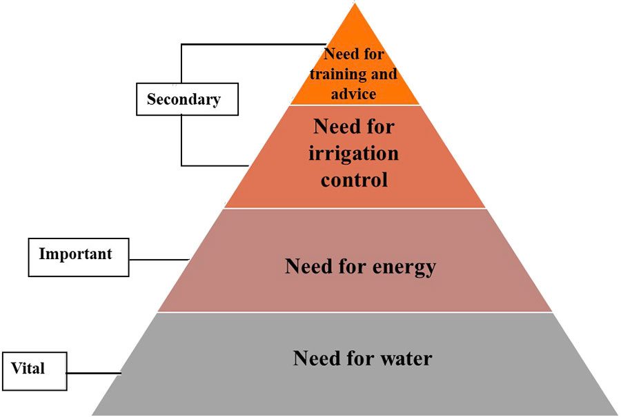
👉 14 of the 15 farmers rely solely on direct observation of the soil and plant to decide when to start irrigation. The farmer's observation focuses on changes in plant characteristics such as color changes, leaf curl and wilting, as well as on the water content of the surface layer of the soil to determine whether the plant still has water. Climatic hazards (rain, wind, temperature, etc.) and the crop's growth stage also have an impact on the choice. The decision is based solely on the farmer's experience, with no knowledge of the precise quantities the plant needs, and no awareness of the water losses caused by these conventional practices. Ten of the farmers interviewed are satisfied with their methods because they are effective, but also because they have no other choice and it's difficult to convince them otherwise. On the other hand, 5 people expressed dissatisfaction with their practices: they feel that these methods are tedious, require a lot of follow-up, are imprecise, and above all lead to water losses, root hypoxia (oxygen deficiency) due to excess water, and heterogeneous distribution on the plot. Most farmers are satisfied with localized irrigation, which requires less work and seems to consume less water. As one farmer put it, "water pushes water", meaning that the water added by flood irrigation pushes water under the root zone.
We then categorized farmers' priorities as follows:
|
▲ Farmers' priorities |
- Deployment of experimental sites
We worked on four experimental sites, three of which were specifically deployed as part of the IRRISAT-MOROCCO project (see Application sites).
- Sharing of near-real-time measurement data from partners
Several of the project's institutional and scientific partners (ORMVAH, INRA, LMI TREMA) have made their near-real-time weather measurements available to SCO IRRISAT. These local measurements provide a relatively fine, in situ network of the main weather parameters, such as wind speed, solar radiation, air temperature, relative humidity and precipitation. For our part, we have developed computer interfaces for downloading and updating our databases.
- IRRISAT and SAT'IRR platform upgrades
With a view to moving towards two interconnected platforms, several improvements have been made:
- A database common to both platforms has been set up for in situ measurements (weather, irrigation, soil moisture). This database makes it easier to interact with data providers via dedicated APIs.
- IRRISAT shares:
- A back-office interface has been developed for more agile task launch management.
- Production of crop maps
- A study has been carried out to improve the spatial resolution of surface temperature. The best solution found so far involves Machine Learning between Landsat and VIIRS observations. The performance obtained is globally satisfactory (average error of 2.02°), but still insufficient for energy balance resolution.
- SAT'IRR shares:
- These data are now managed in a dedicated database, and other indicators such as NDWI (humidity) can be easily generated.
- Since it is now possible to ingest multiple sources of weather data, an orchestrator can be used to manage the priority of use of data sources.
- A specific model for trees and vineyards based on the work of Allen and Pereira, 2009 has been implemented.
- Parallel water balances can now be used to assess the impact of different irrigation triggering alternatives (e.g. sprinkler irrigation vs. drip irrigation).
- Finally, the application's IT security has been completely overhauled (ingestion prevention, captcha, etc.) to enable deployment at the CRTS.
RESULTS - FINAL PRODUCTS
We present here the main results obtained during the 18 months of the project. These results and the above methodology are detailed in the final report, which will be soon available for download.
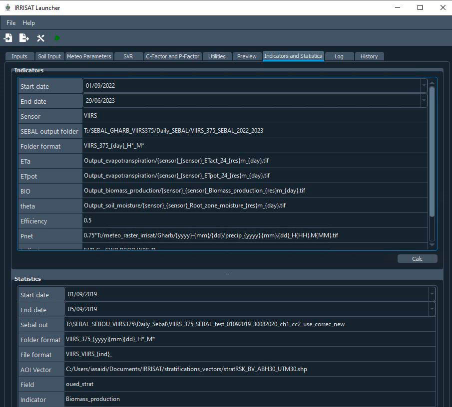
Back-office interface for generating IRRISAT products
The generation of products from the SEBAL energy balance model, and the resulting indicators of water consumption, demand and productivity, requires the definition of several configuration parameters. An interface that integrates all these parameters and functions for generating, visualizing and analyzing the above-mentioned products. In particular, it enables:
- Generate maps of evapotranspiration, biomass and soil moisture, output by the SEBAL model, from Landsat and VIIRS satellite data,
- Generate water consumption and productivity indicators,
- View the different products generated,
- Generate product statistics based on user-defined territorial breakdowns, such as crop types by administrative division.
|
▲ Interface for generating indicators and spatio-temporal statistics. © CRTS |
▲ Example of visualization through the interface of the evapotranspiration product generated from the VIIRS sensor. © CRTS |

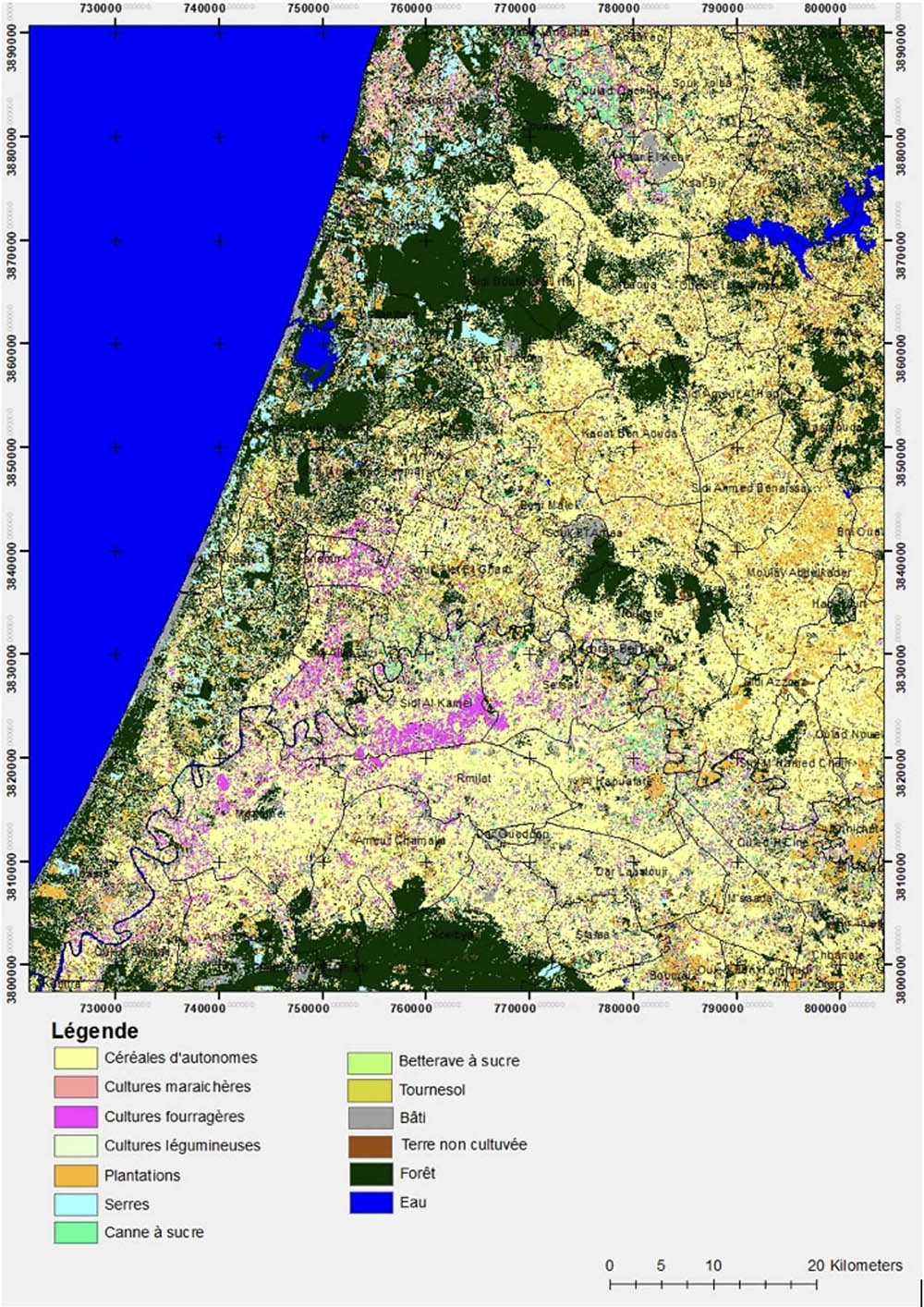
Bi-annual land use mapping
|
In energy balance modeling, crop height is an important parameter. Knowledge of crops enables vegetation height to be calculated as a function of crop type and leaf area index. The crop map is also very important for managers such as ORMVAs and ABHs, as it enables analysis of water consumption by crop. 👉The production of crop maps based on Sentinel-2 high spatial resolution imagery uses the IOTA2 processing chain developed at CESBIO (https://docs.iota2.net) and implemented at CRTS. The overall approach consists in training a classifier (random forest) on a time series of satellite images. ► Map of Gharb crops in winter 2023 based on a series of Sentinel-2 images. © CRTS |
|
Production of indicators for the Sebou basin and the Gharb irrigated perimeter for the years 2019-2020, 2021-2022 and 2022-2023
|
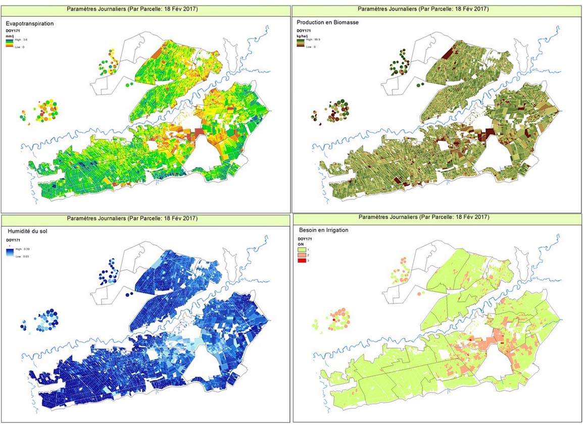
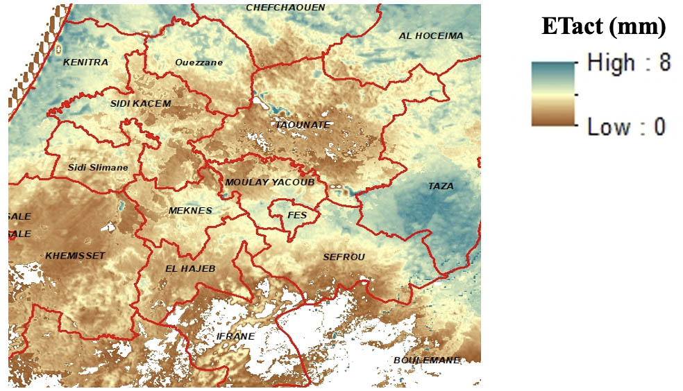
The IRRISAT platform was used to generate maps of actual evapotranspiration, biomass and soil moisture:
|
▲ Map of actual evapotranspiration on July 10, 2020 in the Sebou watershed |
|
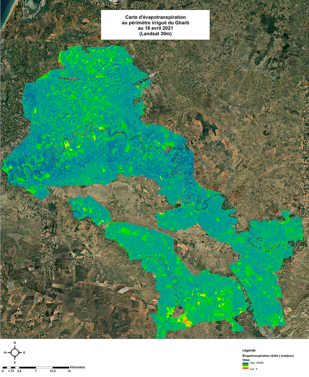
▲ Real evapotranspiration map of the Gharb irrigated perimeter on April 18, 2024. © SCO IRRISAT |
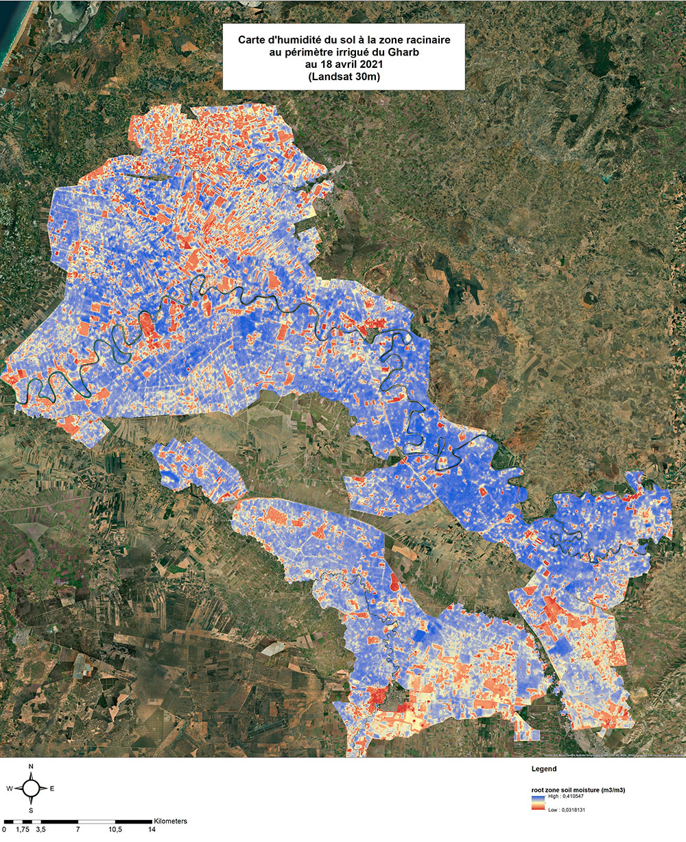
▲ Map of soil moisture at the root zone in the Gharb irrigated perimeter on April 18, 2024. © SCO IRRISAT |
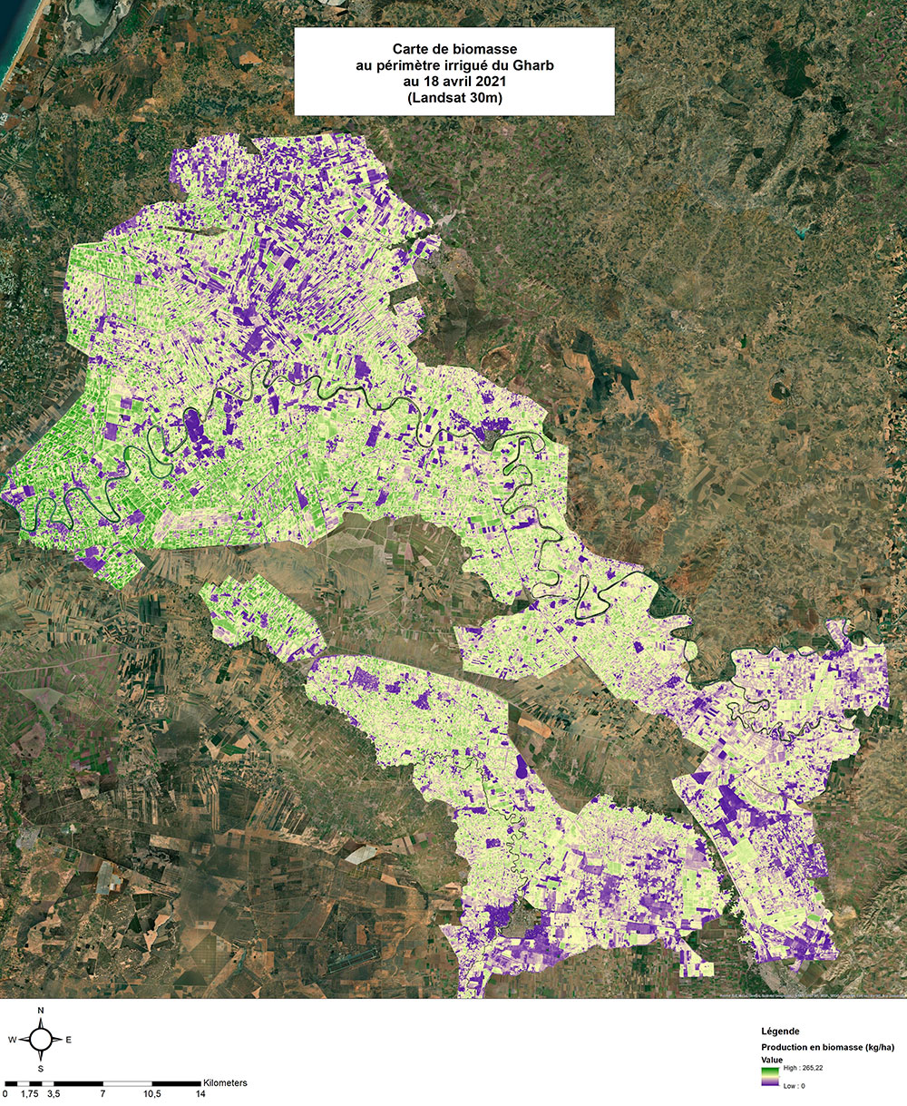
▲ Biomass map of the Gharb irrigated perimeter on April 18, 2024. © SCO IRRISAT |
|
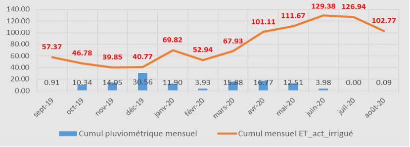
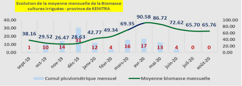
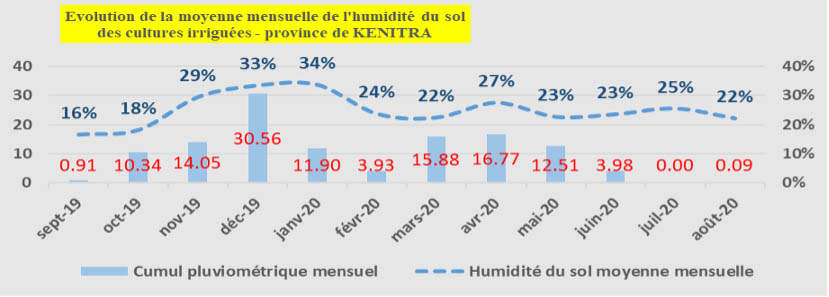
Spatio-temporal summaries are generated for the communes and provinces of Gharb, according to the main agricultural strata (arboriculture, field crops, etc.). The figure opposite shows examples for the province of Kénitra, with a) a comparison between rainfall and water demand for irrigated crops, b) the corresponding biomass production, and c) the soil moisture level. |
a) Monthly trends in average water consumption for irrigated crops
b) Monthly trends in average biomass production of irrigated crops
c) Monthly trends in average soil moisture for irrigated crops |
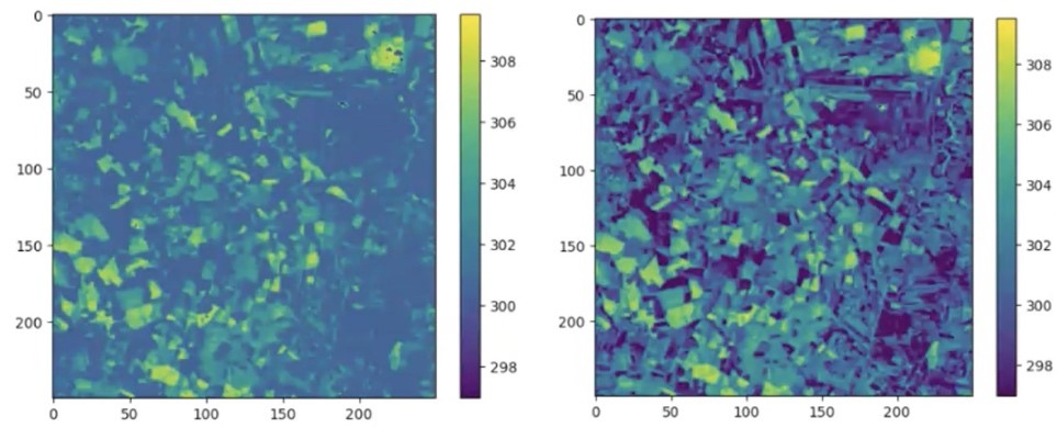
Towards an improved resolution of the VIIRS thermal channel from Landsat and Sentinel-2
|
With the aim of producing indicators at a daily frequency with good spatial resolution, research was carried out to disaggregate the resolution of the VIIRS sensor's thermal channel from 375m to 30m/20m using Landsat/Sentinel-2 sensors. This research tested machine learning and deep leraning algorithms to link the VIIRS thermal channel with Landsat and Sentinel-2 reflectances. |
▲ Enhancement of VIIRS low-resolution thermal data (375 m, left) with Sentinel-2 and LandSat8 data (30 m, right). © SCO IRRISAT |
An offline simulation of SAT’IRR on a corn plot in Chichaoua in 2021-22
|
This experiment consisted in running the tool with old local data, and comparing evapotranspiration estimates with measurements made by an Eddy-covariance device. The model performs very well for this crop when the weather (ET0), water inputs (rain, irrigation) and parameterization (soil, plant) are correct. |
▲ Evapotranspiration measurements and estimates on a corn plot in Chichaoua from October 2021 to March 2022. © SCO IRRISAT |
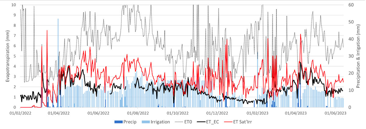
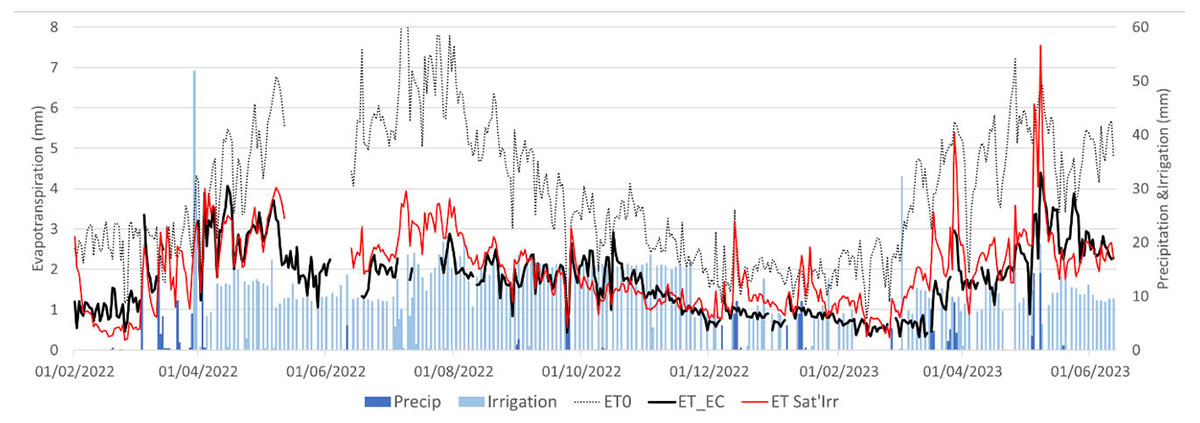
An online simulation of SAT’IRR on the Chichaoua olive plot in 2023
In this experiment, a weather station measures precipitation, wind speed, air temperature and humidity, as well as global radiation every 30 minutes. The irrigation gauge measures the quantity of irrigation every 100 liters and accumulates it every 30 minutes. The two stations transmit their measurements independently to the server twice a day. SAT’IRR ingests weather and irrigation data once a day. SAT’IRR also searches for new Sentinel-2 images and, if available, processes them and calculates the basic crop coefficient (Kcb), i.e. the coefficient weighting water consumption according to plant. Weather forecasts are finally ingested for the following days. Kcb is also extrapolated for the same period.
|
The figure opposite compares the calculation of reference evapotranspiration from data transmitted in near-real time by the weather station with that from post-processing. The weather station data is subject to transmission errors and data gaps, which can be relatively common in areas with poor mobile phone coverage. SAT'IRR's near-real-time estimation of actual evapotranspiration was unfortunately badly affected by this problem with the transmission of weather data (figure below), although the problem is corrected with correct weather (second figure). |
▲ Evapotranspiration measurements and estimates on an olive plot in Chichaoua from February 2022 to June 2023. Top: meteorological data from the nearest station, bottom: post-processed meteorological data. © SCO IRRISAT |
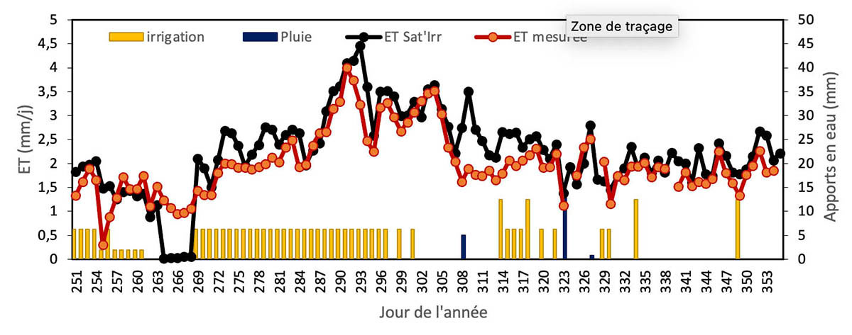
Multiple water balances in SAT’IRR
|
It is now possible to launch several irrigation alternatives with SAT’IRR. In the figure below, irrigation is simulated from November 12, 2023, with the future ET0 derived from weather forecasts for the first 5 days, then the ET0 from the average climate recorded at this point over some 30 years of measurements (a climatology). SAT’IRR separates the main water balance into four instances: flood irrigation, sprinkler irrigation, standard drip irrigation, deficit drip irrigation. |
▲ SAT'IRR simulation of water supply scenarios according to irrigation techniques. © SCO IRRISAT |
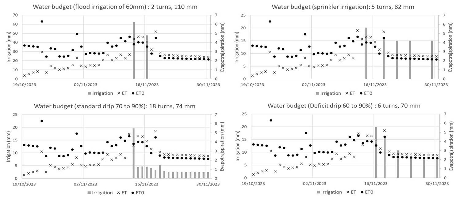
The resulting irrigation scenarios are very different and allow the user to perceive the impact of alternative irrigation methods.
Conclusions and outlook
Much has been achieved in terms of partnership agreements, software development, experimental facilities and surveys during IRRISAT-MOROCCO, but the road ahead is still long and uncertain.
Software improvements are needed on both sides, on the server side as well as on the client interface. The integration we wanted to achieve will require further work. As new thermal space missions come on stream (Constellar, Thrishna, ESA LST), processing chains will have to be adapted. Given the platform's ability to handle the various inputs correctly, it seems possible to run alternative models of evapotranspiration estimation in parallel and in near-real time, which would provide a better estimate of the uncertainty inherent in these approaches.
On the user side, the project has enabled us to set up some very interesting collaborations and to deploy new experimental plots with different types of crops. However, the experimental plots are all drip-irrigated, and it would be useful to extend the sample to include at least one plot of extensive flood- or sprinkler-irrigated crops.
From now on, the aim of our work with farmers will be to better understand their needs, by comparing their own understanding and experience with sensor measurements, which are very local, and plot-based estimates from the model.
In the near future, once the security issues surrounding access to the SAT'IRR server have been resolved, the SAT'IRR distribution platform will be accessible to a dozen or so farmers or cooperatives selected in advance by our local partners, enabling us to obtain feedback on the subject.
Finally, CRTS and CESBIO are currently working together to develop a common platform for the two approaches IRRISAT MOROCCO project.
Project news
- 11/06/2024: IRRISAT: satellite data for water strategy
- 21/12/2023: Presentation of the IRRISAT project and its progress at the 11th Quarterly Meeting of the SCO France "Innovative services for resilient farming practices".