

SCOFrance
PartnersCerema, Agenium IT Systems, Terranis, Airbus DS, CNES
Useful linksProject page
🎥 Presentation at the 15th Quarterly in December 2024
News: Start-up in situ
Key wordsUrban environment, land use, flooding, runoff, hydraulic model, risk management, forecasting
P4UF, a pioneering flood risk assessment project
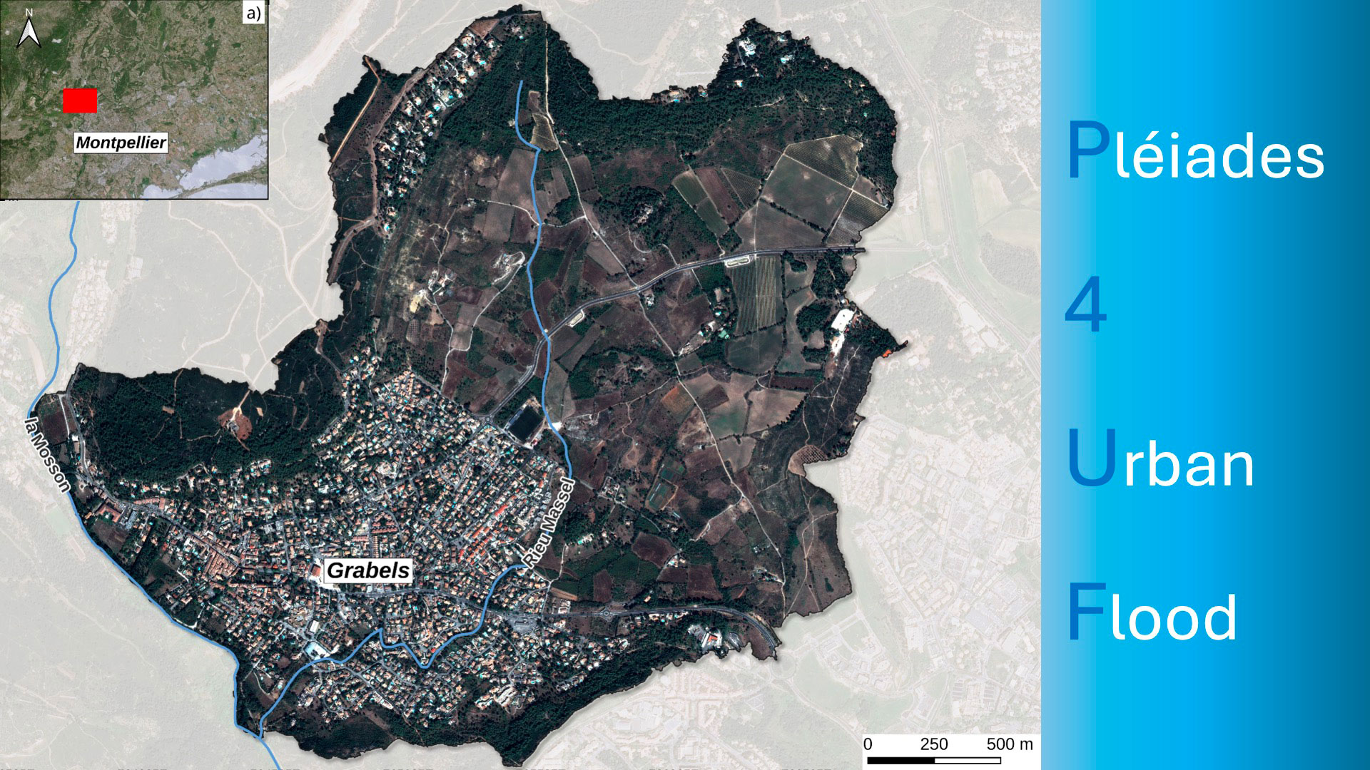
Launched in summer 2023, the SCO Pléiades4UrbanFlood (P4UF) project exploits the 2012 to 2024 archive of 8 very high-resolution monoscopic images from the Pleiades and Pleiades Neo satellites, at 50 and 30 cm resolution respectively. The area of interest is the French town of Grabels, near Montpellier, which was hit by exceptional flooding in 2014. Given the urban growth of this small town and the natural disasters it has already suffered, the objective is threefold: to produce a first-description land-use map (LULC), to assess the extent to which these images can feed a two-dimensional hydraulic runoff model, and to evaluate the impact of land-use changes potentially linked to climate change (fires, for example) on flood risk (maximum water velocities and heights reached).
First year: building technical skills
In the first phase of the project, the various private partners collaborated to produce a land use map (LULC) based on a monoscopic image, i.e. without height information.
- Agenium IT & Systems focused on the detection and characterization of buildings.
- Terranis has produced a vegetation layer distinguishing between tree, shrub and herbaceous strata.
- Airbus Defence and Space set out to classify and aggregate the other components of LULC.
This step also enabled to test the technical continuity between Pleiades and Pleiades Neo.
Second year: first operational LULC map and hydraulic model
|
In autumn 2024, the partners delivered the first complete LULC map. Cerema then took over, using this map as input data for the hydraulic runoff model (Telemac2D), in addition to rainfall data. "The maximum water heights recorded following the October 2014 flood event are reproduced in some cases with an uncertainty of 20 cm, which is very encouraging", says Teodolina Lopez, research engineer at Cerema, confirming the effectiveness of the method. |
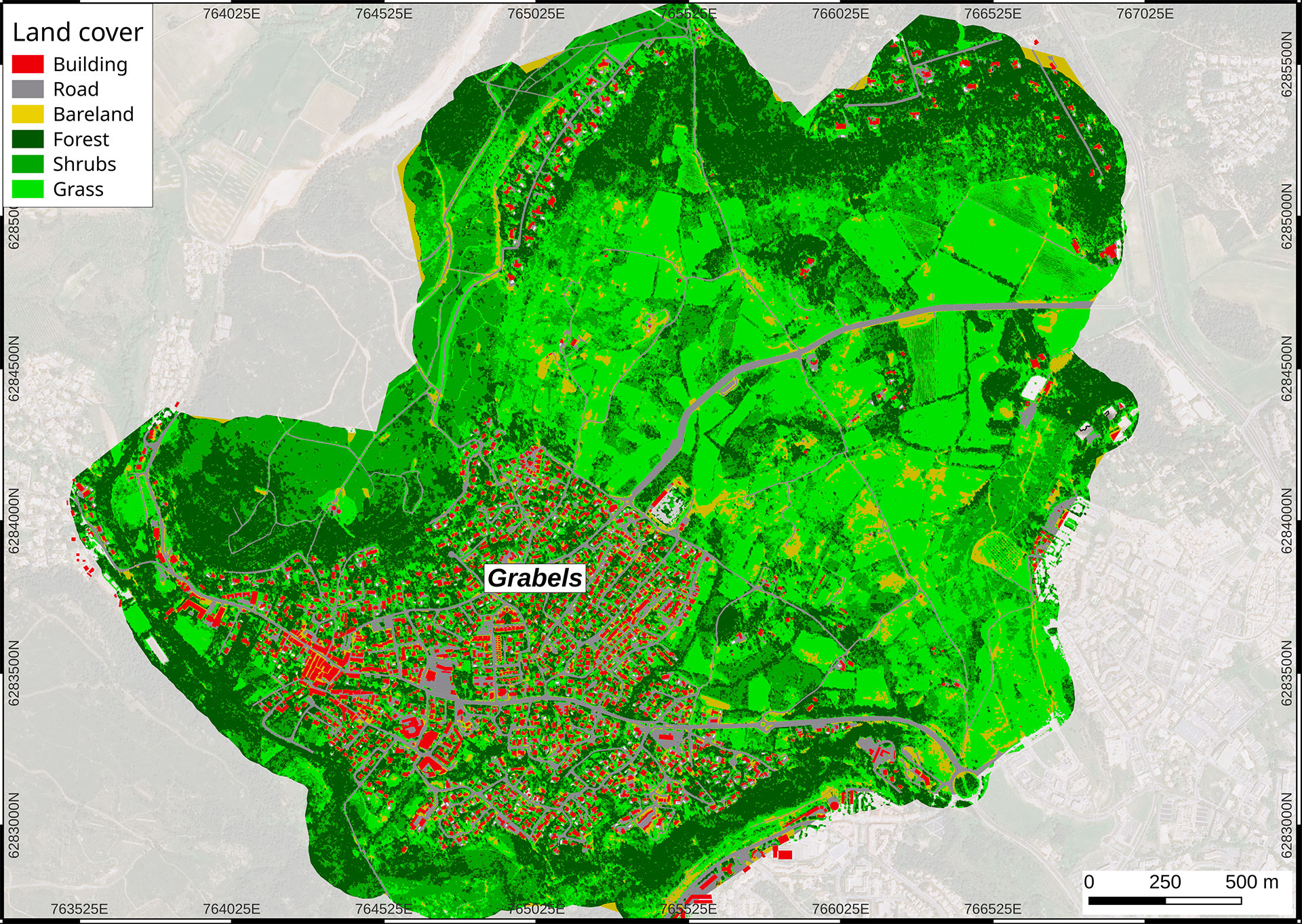
▲ First land use map, based on the Pleiades monoscopic image of 27-08-2020, with 6 classes: buildings produced by Agenium IT Systems, three vegetation classes by TerraNIS, roads and bare ground produced by Airbus DS. Base map: SPOT-7. © Cerema |
On the basis of these encouraging results, the project entered a more in-depth phase:
- Private partners are working on the production of LULC maps, corresponding to the other 7 years of the archive.
- To assess the influence of LULC modifications on the flood hazard, Cerema applies the hydraulic model fed with the rainfall characteristics of the 2014 flood event to subsequent LULC maps, for which the land and its uses have evolved, responding in particular to a population growth of 13.02% between 2015 and 2021.
Let's take two concrete examples of phenomena likely to have an impact on flood risk:
- Fire: in 2017, a fire destroyed part of the vegetation upstream of Grabels, accelerating the flow of water. Thanks to the availability of two Pleiades images taken before and after this fire, it will be possible to determine its impact on the flooding dynamics of the 2014 event using the post-fire LULC and 2014 rainfall in the demonstrator.
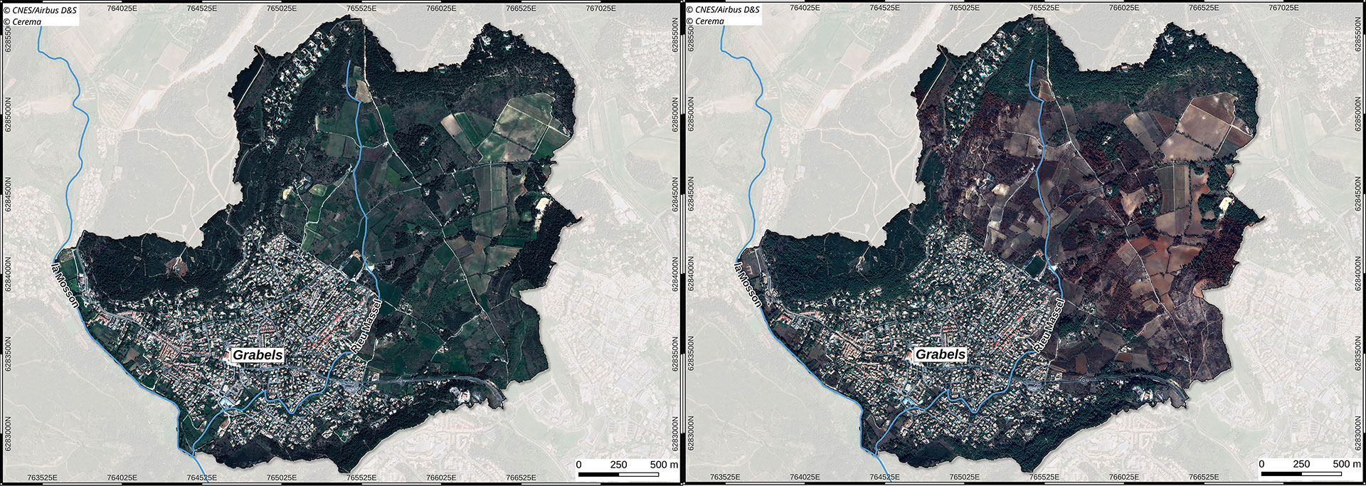
▲ Pleiades images before the fire on the left (March 29, 2017) and after the fire on the right (October 24, 2017). © CNES/Airbus DS/Cerema
- Urbanization: the most recent image, a Pleiades Neo acquisition from 2024, shows denser urbanization, with more obstacles slowing down runoff, while the "canyon" effect of the streets accelerates it, as well as the construction of infrastructures to slow down runoff. Will the hydraulic model of Grabels, fed by 2014 rainfall and the new LULC of this current urbanism, reveal an evolution in flood risk?
The home stretch
|
As a major methodological innovation, P4UF removes technical barriers, with private partners consolidating the use of advanced satellite data, as well as scientific ones, with Cerema, a public-sector player, testing the integration of this data into hydraulic modelling. |
Just as the Thermocity project paved the way for the exploitation of thermal spatial data, P4UF paves the way for other uses, this time of very high-resolution monoscopic imagery: flood risk assessment, targeting of field missions, evaluation of the effectiveness of developments in the face of extreme events... |
Subject to completion of the final work, P4UF will deliver:
- LULC maps for all years of the Pleiades archive (by private partners).
- Maps estimating the impact on the flood hazard of more intense rainfall events, drawn up in line with IPCC forecasts, i.e. up to 5% increase in intensity, with and without changes in urban planning.
- A platform for visualizing results (by Terranis) in the form of interactive maps.
- A guide describing the methodology for quantifying the uncertainties introduced by the use of Pleiades images for urban runoff flood hazard modeling, using the Telemac2D (opentelemac.org) and Cartino2D (developed at Cerema) tools.
See you in the last quarter of 2025 for the project's completion! In the meantime, don't hesitate to follow P4UF's presentations at the following events:
- Cerema hydraulic modelling club, May 21 and 22, 2025
- SimHydro 2025, June 2-4, 2025
- Living Planet Symposium, June 23-27, 2025 (session A.07.05)