

SCOInternational
95Projects label accredited
47SCO signatories to date
Useful linkSCO France 2024 Edition
Next international meetingSteering committee on 28/5/24
Key words2024 Edition, projects in China, Gabon, Italy, the Philippines, the UK and the USA, SCO label
SCO International: 2024 Edition
|
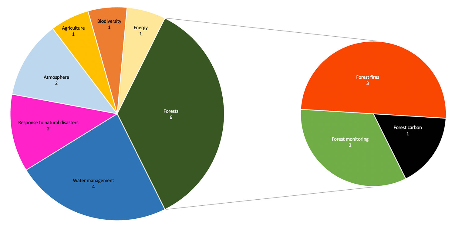
Water, air, earth and fire. The 17 projects approved by the SCO are perfectly aligned with the four elements, demonstrating the extent to which climate change is affecting our planet and, indeed, our societies. More than a third of these projects are concerned with preserving forests, which is at the heart of their concerns and efforts. |
|
Consult this article regularly, to which we will link the pages presenting the various projects as they come on line.
🇨🇳 SCO in China: 6 projects
Supported by the Aerospace Information Research Institute, Chinese Academy of Sciences
Theme: Atmosphere
Due to the increase in emissions from human activities, atmospheric particles reduce visibility, affecting traffic and life, while their long-term inhalation can damage human health. In addition, meteorological conditions and ecosystems, which can to some extent prevent sand and pollution, have become more unstable, inducing more frequent and severe dust and haze events in recent years. In order to improve people's ability to adapt to these weather situations, which have become elusive by climate change, the DUST project aims to develop an operational early warning system for serious dust and haze events.
Supported by the Aerospace Information Research Institute, Chinese Academy of Sciences
Theme: Forest fires
The aim of this project is to develop an early warning system based on a comprehensive and accurate of forest fires risk by combining various data (notably ERA 5 meteorological data and vegetation indices extracted from the CBERS-4 satellite) and using neural network technology. The resulting risk profile will help forest owners to proactively implement prevention measures.
Supported by the Aerospace Information Research Institute, Chinese Academy of Sciences
Theme: Water management
This project is developing a method for estimating irrigation water use by combining physical models and AI algorithms fed with satellite data and economic statistics. This approach should facilitate reliable estimation of irrigation water for the main crops across China, as well as the development of large-scale projections for future climate change scenarios.
Supported by the College of Resources and Environment, University of Chinese Academy of Sciences
Theme: Water management
As sentinels of global climate change, lakes play a crucial role in the water cycle, ecosystems and climate patterns. Predicting their future levels is essential for understanding hydrological processes in a changing environment, promoting sustainable water management and mitigating flood disasters and environmental destruction.
In this context, HydroLake aims to improve lake level forecasting by assimilating hydrological models with observations from space-based laser altimeters. The model is expected to take into account both the effects of future climate change, based on CMIP6-SWAT climate projections, and lake levels based on the latest observations from the ICESat-2 satellite. Based on satellite observations, the model should be able to be applied to any lake in the world.
Supported by the Aerospace Information Research Institute, Chinese Academy of Sciences
Theme: Atmosphere
Monitoring, measuring and reducing methane emissions from coal mines is crucial to combating climate change and global warming in the short term. Developed in China, one of the richest countries in terms of coal reserves, this project will use Sentinel-5P satellite data and the Gaussian plume model to estimate methane emissions from large high-gas coal mines. By converting satellite observations into point source emissions with a high degree of accuracy, the results will be combined with an emissions inventory to ensure their reliability.
Supported by the Aerospace Information Research Institute, Chinese Academy of Sciences
Theme: Energy
This project will develop a tool for forecasting photovoltaic production on the scale of several Chinese regions by integrating various hypotheses of climate change and extreme events, using meteorological and topographical data and information on the distribution of photovoltaic panels on a regional scale.
🇬🇦 SCO in Gabon: 1 project
Supported by Gabonese space agency AGEOS
Theme: Forests
This project uses Earth observation tools to help characterise the functioning of mangroves in Gabon, support their management and optimise their preservation and development. To this end, it is developing a mangrove monitoring and management platform designed to provide a sustainable response to the problem of the degradation of these precious ecosystems.
🇮🇹 SCO in Italy: 2 projects
Supported by Euro.Soft srl
Theme: Carbon
CACAO is an innovative platform designed to enable carbon credits to be traded on a voluntary basis through integrated service cycle management, from the analysis and quantification of the CO2 sequestered by a forest area to the management of trading between landowners and private companies wishing to improve their environmental footprint.
- FOTROSMOD, FOrest TROpical Satellite Monitoring for Disturbances
Supported by Tor Vergata University
Theme: Forests
By producing a dataset of forest variables over the entire tropical belt from 2011 to 2023, the FOTROSMOD project aims to demonstrate the capacity of radar satellite data to provide a monthly monitoring service for forest variables, including logging, and to show their evolution in a context of climate change. To achieve this, it aims to engage local stakeholders in sharing data and initiatives to sustain effective forest management and rationalise the use of FOTROSMOD datasets. In doing so, the project also plans to train young researchers motivated to engage with stakeholders in developing countries to improve the services provided.
🇵🇭 SCO in the Philippines: 3 projects
- NOAH, Nationalwide Operational Assessment of Hazards
Supported by University of the Philippines, Resilience Institute
Theme: Response to natural disasters
A risk reduction and management project, NOAH offers a range of tools and information to improve disaster preparedness in the Philippines. It provides access to near-real-time data, hazard maps, weather forecasts and other essential information to help government agencies, local communities and the general public make informed decisions and take action to mitigate the impact of disasters.
- SMOOTH, Surface soil moisture as a flood indicator
Worn by Josefina H. Cerilles State College
Theme: Water management
The project aims to overcome the limitations of conventional methods of measuring soil moisture by exploiting remote sensing technology and machine learning algorithms. Using Sentinel-1 radar data, the mapping tool will provide near-real time soil moisture information at high spatial resolution, enabling more effective decision-making for flood and drought forecasting, among other applications.
Supported by the Philippine Space Agency PhilSA
Theme: Agriculture
The agricultural sector in the Philippines is highly vulnerable to climate-related risks, particularly agricultural droughts, which are increasing in frequency and intensity. Using the results of the "Drought and Crop Assessment and Forecasting (DCAF)" research initiative, this project will establish agricultural drought monitoring and forecasting maps based on satellite data (rainfall, LST surface temperature and NDVI vegetation index). As the project is being carried out in collaboration with the government agencies concerned, the results will serve as a basis for developing a national policy on early warning and monitoring of agricultural drought.
🇬🇧 SCO in the United-Kingdom: 2 projects
Supported by Surrey Wildlife Trust and University of Surrey, Centre of Environment and Sustainability
Theme: Biodiversity
Space4Nature combines Earth observation, citizen science and AI machine learning to produce maps to plan and monitor the recovery of nature in Surrey (England) and beyond. By inviting as many stakeholders as possible, including local communities and landowners, to use this approach to implement nature-based climate resilience and mitigation measures, one of the key outcomes will be to reverse habitat fragmentation, a key driver of biodiversity loss, by creating corridors of restored and/or managed land for nature.
Supported by Earth Blox and the University of Edinburgh
Theme: Response to natural disasters
The links between environmental change, climate stress, conflict and population vulnerability are complex, and access to data on such topics is not straightforward. This was the motivation behind the development of Strata, designed to help more than 130 UN country teams gather data from a variety of sources. By identifying the stresses from different sources and converging them together into one platform, users are able to see and locate the 'hotspots' - those areas most at risk.
🇺🇸 SCO in the USA: 3 projects
Supported by NOAA National Centers for Environmental Information
Theme: Forest fires
NOAA is developing an advanced capability for predicting wildfire risk and burn behavior based on weather forecasts and land cover information. By investigating both long- and short-term conditions before fire outbreak periods, the project will leverage artificial intelligence and diverse datasets to understand complex relationships (including the effects of climate change) and ultimately deliver a predictive forecast-driven algorithm that assesses fire risk weeks, months, or possibly even years before extreme fire outbreaks. The initial test areas will include parts of the western U.S. and Alaska where recent wildfire seasons have been led to excessive loss of life and property.
- ARTICFIRE
Supported by NOAA National Centers for Environmental Information
Theme: Forest fires
With Alaska becoming more vulnerable to forest fires due to shorter winters and melting permafrost, the aim of this project is to develop a tool for measuring snowpack melt that maps its evolution in near-real time using NOAA's polar satellites. It is intended for Alaska's Interagency Coordination Center, which uses the snow cover change data, together with temperature, precipitation, and forest duff status, to estimate fire potential in order to better position its fire-fighting resources.
Supported by NOAA National Centers for Environmental Information
Theme: Response to natural disasters
Using satellites, NOAA provides consistent infrared brightness temperature data for the past 40 years, which it combines with in situ data and models to produce precipitation and surface temperature estimates. With stable results that can be compared with historical droughts and food requirements, these products help to inform those responsible for food security about the extent and severity of droughts and famines. While these products are global, their true benefit is providing information in data sparse regions, such as Africa.