

SeSaM

Seasonal Sargassum Monitoring
Project completedSeSaM has enabled the development and provision of a tool for monitoring and forecasting Sargassum seaweed beds. Monitoring is based on satellite detection of Sargassum banks, and seasonal forecasting, initiated by satellite detection, is based on an ecosystem model that incorporates ocean currents. The data is now available on the project's GIS interface.
Overview
Before 2011, pelagic Sargassum spp. bloomed preferentially in the Sargasso Sea (North Atlantic Ocean area) and in the northwestern tropical Atlantic. They are now found in large quantities on the coasts of the Lesser Antilles, Central America, Brazil and West Africa. Satellite imagery reveals that these strandings come from colossal quantities of algae drifting from the central tropical Atlantic between 0 and 10°N (Wang and Hu 2016, Langin 2018). Recent hypothesis explains this change in the sargassum Atlantic dynamics by a combination of causes from climate change and anthropic factors. It finds its origin with a strong North Atlantic Oscillation anomaly, which has occurred during the winter 2009-2010 causing the sargassum to enter the Northern Equatorial Atlantic Circulation (Johns et al. 2020).
Observing, modeling and forecasting the Sargassum proliferation and strandings are essential for designing effective integrated risk management strategies and is a strong and pressing demand from the civil society.
The aim - achieved - of the SeSAM project is to contribute to the existing international initiatives on this topic (NOAA, GEO blue Planet). It leverages the existing large-scale Sargassum detection operational system developed by CLS (SAMTool), and the innovative growth/transport Sargassum model developed by IRD (ANR FORESEA project). It also relies on the operational capacity and framework of Mercator Ocean International to implement a robust Digital Twin service based on these assets.
SeSAM provides access to the satellite detection products to monitor the evolution sargassum in near real time, and to the seasonal forecast produced at basin scale to help with preparation and mitigation plans in advance.
Methodology
Satellite observations of sargassum
Since 2018, CLS has been developing and operating a monitoring system of the Sargassum situation in real time, based on several satellite sensors. The system produces daily maps of sargassum presence index at 300m resolution. Maps at 20m resolution are also produced every two/three days in coastal areas. These satellite observations cover the full tropical Atlantic (5°S-30°N; 10°E-100°W) and include reprocessed time series which are critical for the seasonal forecast application.
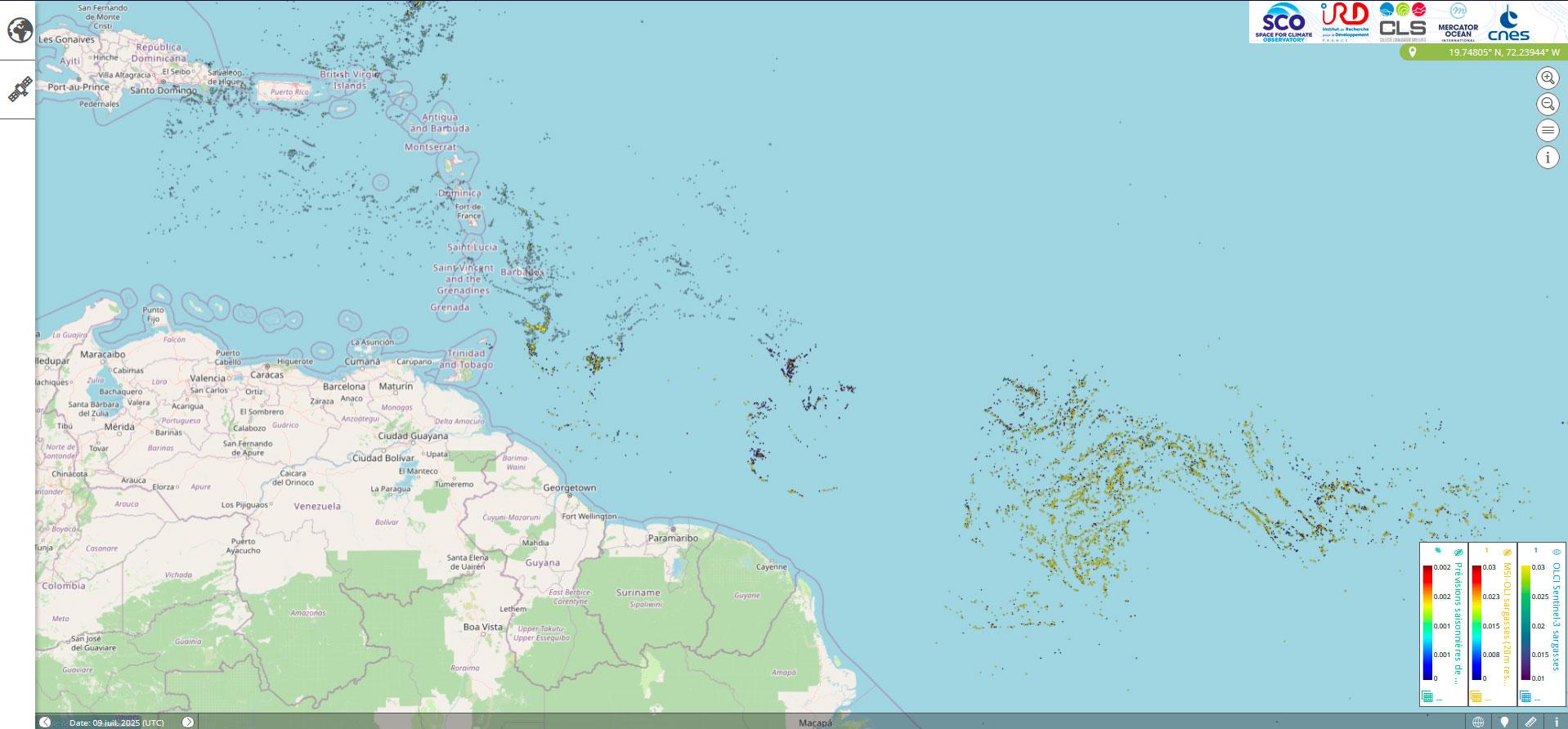
Figure 1. Sargassum detection at 300-m resolution from OLCI instrument on Sentinel-3 for 9th July 2025. © SCO
Seasonal forecasting of sargassum proliferation and influxes
On the modelling side, the ANR project FORESEA (PI J. Jouanno; 2019-2022), funded by the AAP Sargassum in 2019, laid the foundation for the development basin scale sargassum forecasting system. From January 2022, a seasonal forecast has been operated in “best effort mode”. It includes a mechanistic modeling of the Sargassum populations (referred to as NEMO-Sarg1.0 model; Jouanno et al. 2021b) that implement the biology and complex drift properties of the Sargassum rafts and integrates the previsibility of the regional climate system (atmosphere and ocean dynamics).
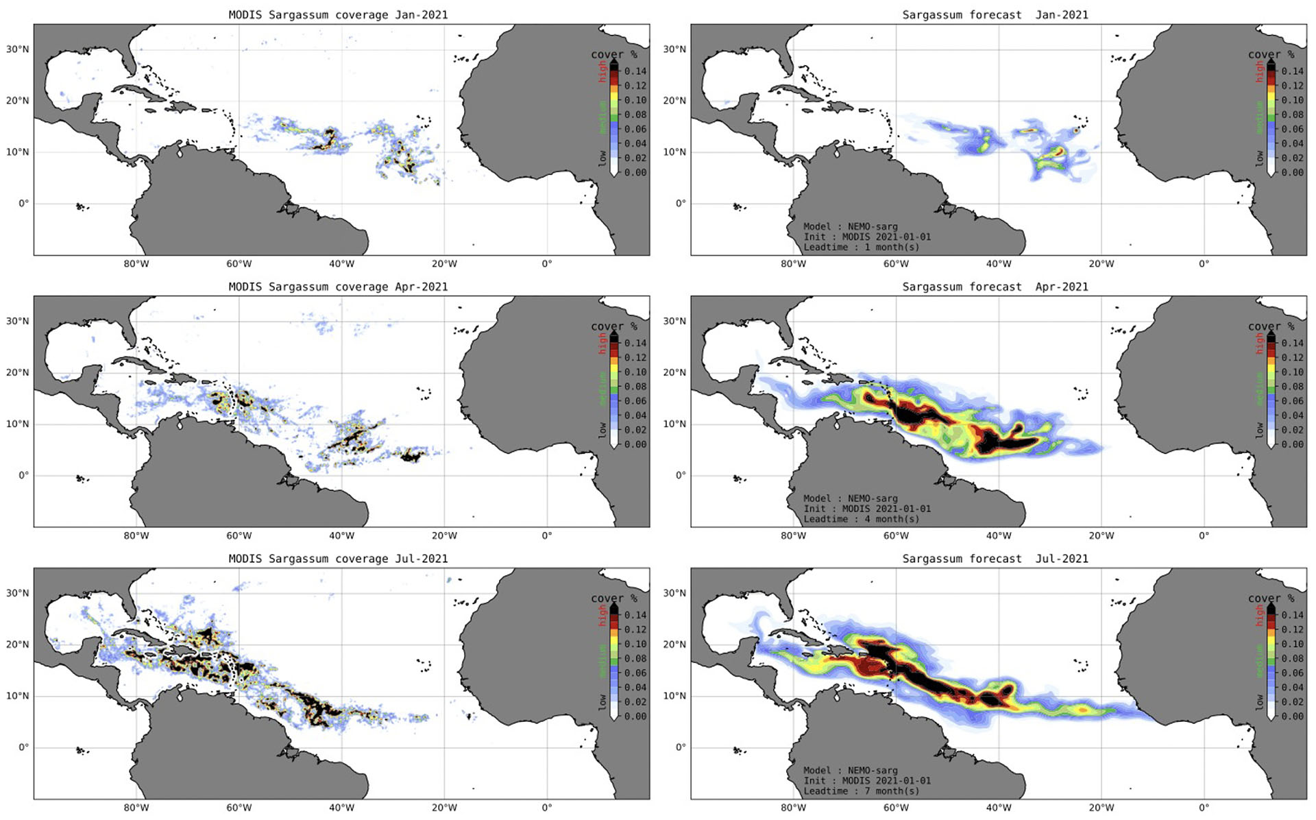
Figure 2. Illustration of the forecasts and ability of the system developed by IRD to predict the large scale distribution of Sargassum with 1 to 7 months in advance. On the left: monthly observations of Sargassum areal coverage (%) obtained from MODIS in January, April, and July 2021. On the right: forecast of Sargassum coverage (%) initialized in January 1st 2021 and shown as monthly averages for 0.5 month lead (January 2021), 3.5-month lead (April 2021) and 6.5-month lead (July 2021) forecasts. The forecast is an average of an ensemble of 25 simulations, explaining why the simulated fields are much smoother than the observed field. © IRD
Application site(s)
Sargassum algae stranding happen on most shorelines of the Tropical Atlantic Ocean, from the Caribbean Sea to Western Africa. The SeSaM project will deliver satellite observation and model forecast to all countries and territories in this region, with a focus on communities with Sargassum management and mitigation plans.
Data
Satellite
- OLCI Sentinel-3
- MODIS Aqua
- MSI Sentinel-2
- OLI Landsat-8 & 9
Other
SEAS5 seasonal forecast from ECMWF (European Centre for Medium-Range Weather Forecasts)
Results - Final products
The outputs of the SeSaM project are open and free, and shared with international community hubs.
👉 The freely accessible mapping platform SeSaM allows users to view:
- the presence of Sargassum seaweed in near real time;
- seasonal forecasts 3 to 6 months in advance for the entire basin to help with preparation and the development of mitigation plans.
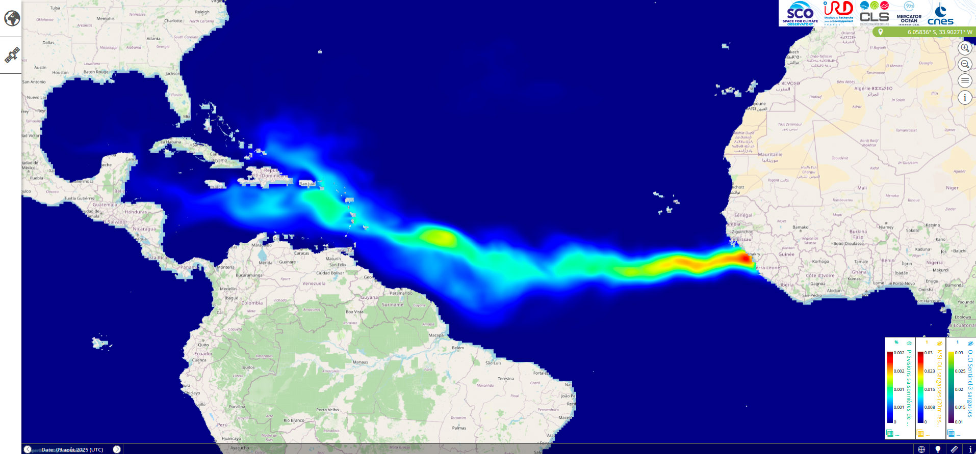
Figure 3. Seasonal forecast of Sargassum presence for August 2025, initialized on July 1, 2025, using the IRD's NEMO-Sarg model. ©SCO
The platform is also available on the international Sargassum Hub portal, co-organized by GEO Blue Planet and IOCARIBE of UNESCO-IOC.
👉 Indicators of sargassum presence derived from satellite images are hosted by AVISO / ODATIS, where they are available to the scientific community.
👉 Sargassum detection products developed by CLS are available in real time from the Copernicus Marine Service CMEMS.
Outlook
Mercator Ocean International will ensure the transition to operational production of seasonal forecasts, based on the model developed by IRD, in order to provide long-term support for the monitoring and prediction of Sargassum strandings. For their part, IRD teams will continue their research aimed at better understanding the large-scale variability of the Sargassum phenomenon through the development and improvement of numerical models of Sargassum distribution.
References
| SeSaM on GEO Knowledge Hub, a long lasting digital repository created by the Group on Earth Observations: https://doi.org/10.60566/77n6t-7n818 |
-
Jouanno, J., Morvan G., Berline, L., Benshila R., Aumont, O., Sheinbaum, J., Ménard, F (2023). Prévision saisonnière habile de la prolifération des Sargassum dans l'Atlantique Tropical. En révision GRL.
-
Jouanno, J., Benshila, R., Berline, L., Soulié, A., Radenac, M.-H., Morvan, G., Diaz, F., Sheinbaum, J., Chevalier, C., Thibaut, T., Changeux, T., Menard, F., Berthet, S., Aumont, O., Ethé, C., Nabat, P., et Mallet, M. : A NEMO-based model of Sargassum distribution in the Tropical Atlantic : description of the model and sensitivity analysis (NEMO-Sarg1.0), Geoscientific Model Development, 14(6), 4069-4086.
Related projects
-
ANR project FORESEA (Forecasting seasonal Sargassum Events in the Atlantic, PI J. Jouanno ; 2019-2023),
-
CLS, SamTOOL system
-
TOSCA SARGAT (Pelagic Sargassum aggregations and transport ; PI J. Jouanno ; 2023-2025)
-
SODA project (Sargassum Operational Detection Algorithms) from Copernicus Marine Service
-
Digital Twin Ocean from Mercator Ocean
Project News
-
26/11/2025: Thanks to SeSaM, Europe now has a tool for monitoring and forecasting sargassum
-
🎥 23/06/2025: Presentation of the SeSaM project and its progress at the 17th SCO France Quarterly Meeting
-
10/04/2025: Tackling the scourge of sargassum with SeSaM