

SCOFrance
PartnersCNRS/EOST, A2S, Parc National du Mercantourn IPGP, Séolane, CNES
Usefgul linksProject page
KeywordsChanges, landscapes, biodiversity, vegetation, grasslands, forests
TerEcoData, an on-demand web service for monitoring ecological changes on land
Terrestrial Ecology Data. This is a service that promises to transform the way we study changes in our natural landscapes. As climate change alters habitats, affecting agricultural, pastoral and forestry practices, TerEcoData calculates operational indicators that are essential for monitoring these environments and their ecosystem services. Designed as part of the SCO EO4MountainPastoralism project, TerEcoData is aimed at a wide community of users, mainly those involved in the study of forests, agricultural landscapes, water cycles and biodiversity.
Reliable and tested on numerous sites and use cases, the calculations can be applied to any territory in France and, more broadly, worldwide thanks to the global coverage of Sentinel-2 satellite data. The tool is hosted by the THEIA cluster, drawing on the digital resources of the Data-Terra infrastructure.
A high spatial resolution service
Although similar services already exist internationally, such as Copernicus in Europe and USGS in the USA, TerEcoData stands out for its ability to produce high spatial resolution data (10 meters) and its flexible approach. Rather than replacing these services, it is positioned as a complementary tool, enabling accurate analysis of specific areas of interest.
With TerEcoData, and like the tools provided by SCO projects, there is no need to be a remote sensing expert. The service is based on Sentinel-2 L2A-level data-, i.e. pre-processed to correct for elements such as shadows and clouds, making it an automated and fast tool.
A simple and powerful interface
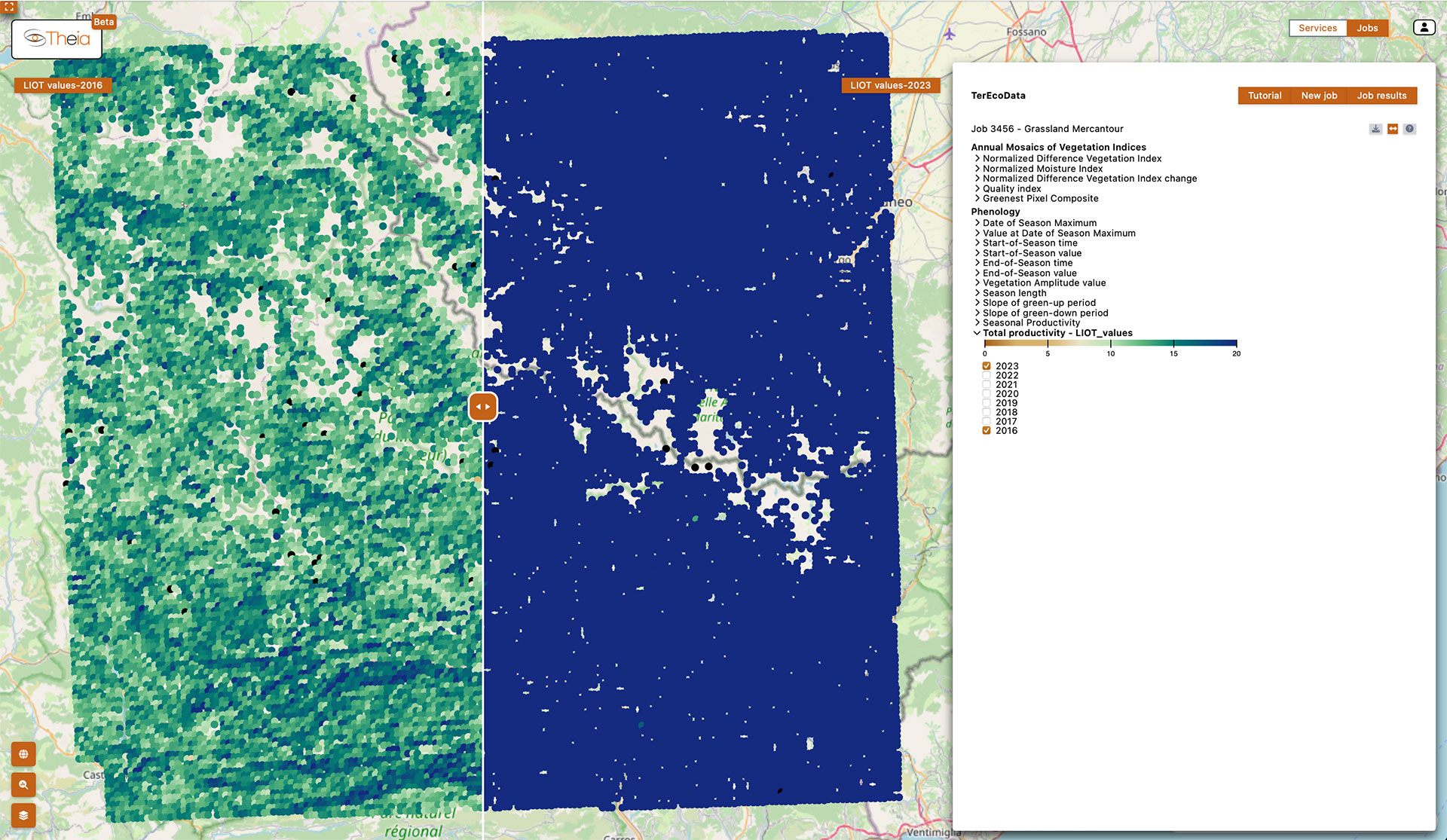
TerEcoData is available via Data Terra's Theia hub. The user-friendly interface offers a simple process:
- The user selects the parameters (image type, geographical area, study period) and the desired vegetation indices (NDVI, NMI, etc.).
- The service automatically calculates the results, which can be viewed in the form of interactive graphs, allowing users to compare images from different years or overlay the calculated indices on maps. A slider tool also allows users to easily compare two images from different dates to observe changes in vegetation or other parameters.
💡 The service keeps a history of calculations for one month, giving users time to save what they want to keep, or even download the entire data cube.
|
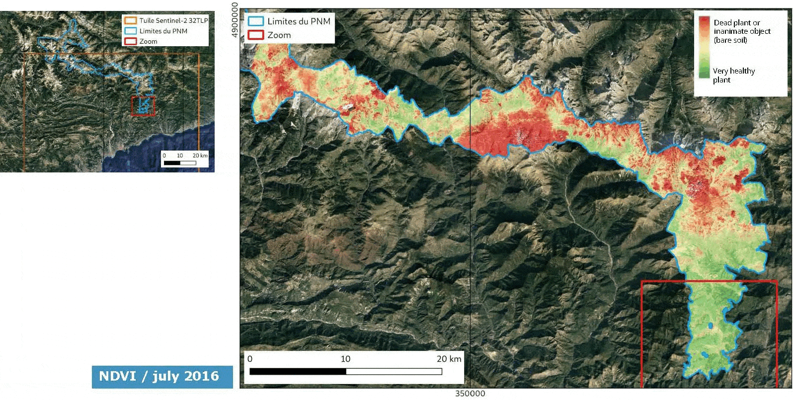
► The service allows users to view and analyze time series, providing a dynamic overview of vegetation changes over the years. Here we see the state of vegetation in French Mercantour National Park from 2016 to 2021, with 'dead' vegetation shown in red and healthy vegetation in green. © EOST/A2S |
|
To use the service, simply create an account and request access from Theia.
Concrete use cases
|
The practical applications of TerEcoData are already visible through several use cases developed in collaboration with field actors to build the service and design the workflow. For example, Mercantour National Park has launched automatic NDVI calculations and mosaics at different dates to visualize and analyze the landscape's vegetation response to water inputs throughout the seasons. |
Application and users French stakeholders, such as national and regional parks and landscape conservation managers were heavily involved in setting up the service and using the output products from the very first prototypes. Other national stakeholders approached are interested, such as water agencies and wetland managers. The service will also be offered, in its already developed English version, to international organizations and/or initiatives (JRC/EU Biodiversity programme, IUCN Biodiversity Programme, GeoBON, African stakeholders in the OFVi programme, IGNFI, etc.). |
Outlook
TerEcoData is designed to be modular and adaptable to different types of projects around the world. The service is already integrated into projects such as One Forest Vision, and its cost model is currently being defined.
Improvements are planned based on user feedback, as well as diversification of source data from different sensors in the medium term.