

Eo4MountainPastoralism

Safeguarding mountain pastoral systems: eco-hydrological indicators from Earth Observation image time series
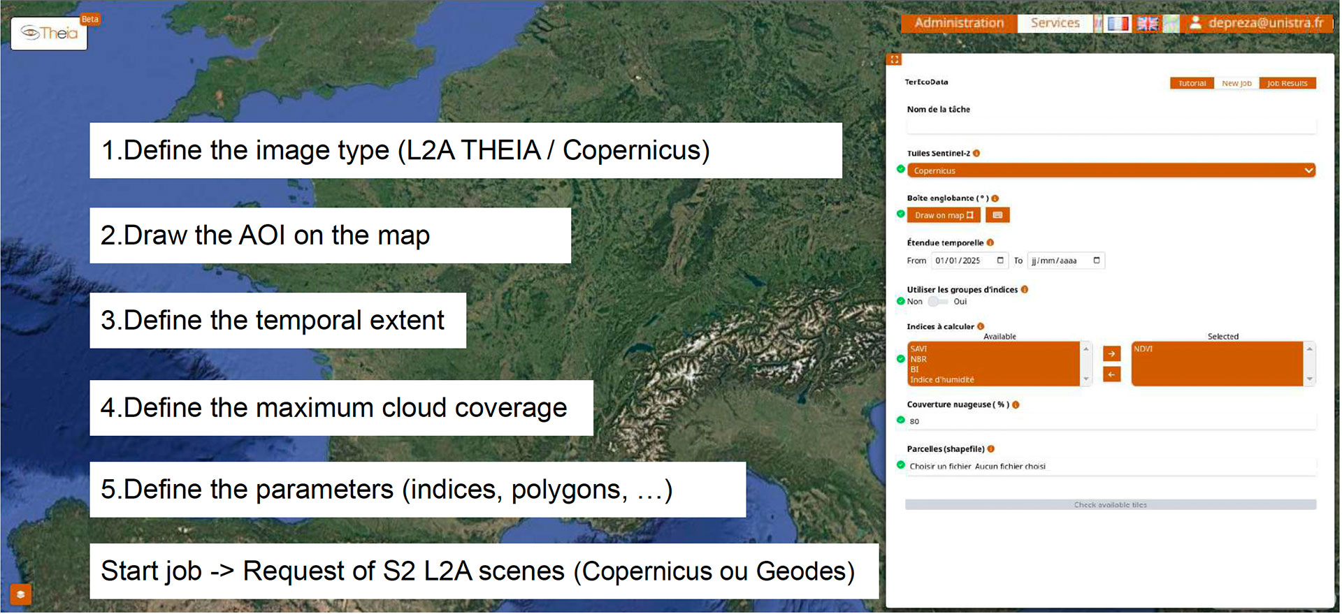
Project completedEO4MP has delivered TerEcoDataTerEcoData, an on-demand service for monitoring ecological changes anywhere. Accessible via a THEIA account, TerEcoData provides advanced indicators of ecosystem properties based on high-resolution Sentinel-2 time series. The results can be viewed in the form of interactive graphs, with the ability to compare images from different years or overlay indices to observe changes in vegetation or other parameters.
OVERVIEW
High altitude wetlands (> 1500 m) are a richness of mountain territories and a natural heritage of the Mercantour National Park (PNM). Mainly located in mountain pastures exploited by pastoralism, this activity can degrade wetlands, their biodiversity and their ecosystem service functions, as well as shallow altitude lakes due to the pollution generated by dejections and trampling.
In the context of climate change, these particularly sensitive environments will be the first to be impacted by summer drought, which is why the PNM has developed a restoration and monitoring plan for all wetlands located in the mountain pastures. The objectives of the plan are 1) to have a dedicated dashboard that links all the data and allows to visualize the state of the wetlands and to measure their spatial and temporal evolutions, 2) to propose a monitoring of the state of conservation of these environments, especially in terms of biodiversity, and 3) to implement actions of reasoned management in consultation with the breeders, the shepherds and the other users. For these three actions, the PNM uses ground observation networks which, for a systematic monitoring, must be coupled with repeated and high resolution satellite observations.
The objective -achieved- of this SCO project was to generate products allowing a fine description of these environments every 15 days (in non-winter period, from March to November) and at high resolution (aggregated pixel of 30 x 30 m) at the scale of the whole territory (685 km2). The basic unit of analysis is the wetlands (and alpine pastures) with a surface of less than 1000 m2 (corresponding to a total surface of about 100 km2 on the territory).
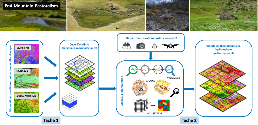
Concept of the Eo4Mountain-Pastoralism project adapted to wetlands and their ecosystem services in the Mercantour National Park territory. © EOST/A2S – PNM, 2021
Application site(s)
France, Mercantour National Park (Alpes-Maritimes and Alpes-de-Haute-Provence)
DATA
Satellite
- Sentinel-2
- Sentinel-1, SPOT 7 and Pléiades data were also tested
Other
- PNM ground observation network
RESULTS - FINAL PRODUCTS
EO4MP has implemented the Terrestrial Ecology Data (TerEcoData) on-demand service. Freely accessible via a THEIA account, this service provides advanced indicators of ecosystem properties based on high-resolution Sentinel-2 time series. Users can select periods/regions of interest, calculate spatial indicators (vegetation indices, phenological stages) and view them in the form of interactive maps.
To do this, TerEcoData uses datacube technology to process massive satellite datasets and derive zonal statistics and time series. The product portfolio consists of a set of quantitative environmental/eco-hydrological attributes and indicators allowing 1) to document the spatio-temporal evolution of studied areas and their properties, and 2) to propose decision support tools for short- and long-term management practices. The products (pixels or statistics per plot) can be used directly on a standard desktop computer for further advanced processing.
Reliable and tested on numerous sites and use cases (including the assessment of the quality and biodiversity richness of grasslands and the health of trees in urban areas), the calculations can be applied to any territory in France, and more broadly on a global scale thanks to the comprehensive coverage of Sentinel-2 satellite data. Designed to be modular and adaptable to different types of projects around the world, TerEcoData is already integrated into projects such as One Forest Vision.
References
| Eo4MountainPastoralism on GEO Knowledge Hub, a long lasting digital repository created by the Group on Earth Observations: https://doi.org/10.60566/bd8n2-vgf78 |
Project news
-
15/12/2025: TerEcoData, an on-demand web service for monitoring ecological changes on land
-
🎥 23/06/2025: Presentation of the EO4MP project and its progress at the 17th SCO France Quarterly Meeting
-
29/06/2023: Presentation of the EO4MoutainPastoralism project and its progress at the 9th Quarterly Meeting of the SCO France "The SCO serving agricultural practices".