

XtremQuality

Monitoring the water quality of small reservoirs
Project completedThe project was completed in February 2026 with the launch of the XtremQuality platform for disseminating the project’s results. Co-funded by the SCO and the Adour Garonne Agency, the project implemented a groundbreaking service - based on satellite remote sensing and AI -designed to monitor water quality in small reservoirs in southwestern France. It enabled the development of a novel processing pipeline for Sentinel-2 satellite data, the validation of these processes, and the deployment of a suite of data post-processing tools to interpret spatial data in light of environmental conditions, particularly climate change. The project thus provides expert users with access to high-resolution products, as well as a series of indices tracking the movement of water bodies in the region, offering a comprehensive overview of the state of these water bodies. The project is continuing into a second phase with the Adour Garonne Agency in the Southwest region and is also expanding to Brazil.
Overview
Context
The creation of water reservoirs is one of the main local responses to try to reduce the impact of climate change by storing part of the runoff during the wet season in order to face the dry season. These practices are common in semi-arid and Mediterranean environments, which are used to droughts lasting several months, and particularly for agricultural purposes (irrigation and livestock feeding). Reservoirs can also play an essential role during severe low-water periods by maintaining ecological flows and thus preserving a role of refuge for the biodiversity of aquatic environments.
These reservoirs are also used in regions with large aquifers to increase groundwater recharge. Dam lakes are expected to increase in regions that will suffer from intensified droughts, as in France, in order to maintain the various uses of water during low-water periods. However, the installation of hydraulic structures, of all sizes, is encountering increasing difficulties of acceptability within society with regard to their impacts on the functioning of aquatic environments and the biodiversity they shelter, calling for an integrated management of these structures to mitigate their negative effects: modification of the upstream-downstream transfer processes of water, sediment, nutrient and pollutant flows
The study of the impacts of climate change on the water cycle is largely conducted from the point of view of the quantity of water available for ecosystems and societies. However, it is now accepted that the question of available water volumes alone is not sufficient to understand the overall impact of climate change. The question of the quality of available water is as fundamental as its quantity, since it is the biophysical characteristics of water that condition its uses and the maintenance of ecosystem services in continental waters.
In this context, it is urgent to better characterize the water quality trajectories of the reservoirs at various scales in order to anticipate their responses to climate change. The expected hydrological and thermal changes will contribute to a direct degradation of water quality induced by the acceleration of extreme events (floods and low water levels) and by a global warming that will favor the processes of eutrophication (pollution of aquatic ecosystems when they receive too many nutrients assimilable by algae and when these proliferate without control).
Goal achieved
Implemented in southwestern France but adaptable to other regions, XtremQuality makes it possible to study the tens of thousands of artificial lakes that are not monitored by the public authorities and whose evolution and impact on aquatic environments are still poorly known. The lakes and reservoirs considered in this project, from 1 ha upwards, constitute a fundamental element of the surface water cycle due to their role for ecosystems (maintenance of ecological flows and biodiversity, storage of nutrients, pollutants and sediments) and for society (irrigation, recreation etc.). In France, the legal monitoring of water quality (governed by the Water Framework Directive - WFD) concerns only 482 lakes and reservoirs larger than 50 ha) out of more than 100,000 estimated for the entire French territory.
👉 In the Southwest region, nearly 3,000 lakes are now monitored by satellite, significantly expanding monitoring capabilities that were previously limited to about 100 reservoirs.
The service thus facilitates policy development for sustainable water resources management, and for the implementation of the Sustainable Development Goals (SDGs), including SDG 6 (clean water and sanitation) and SDG 15 on ecosystems and biodiversity.
Methodology
We propose to study a large part of the 99.6% of lakes that are currently not monitored by public authorities in order to provide new information on the state of these water bodies in the face of climate change. This service is now possible thanks to the arrival of the Sentinel-2 constellation, which offers unprecedented performance in terms of spatial (up to 10 metres), spectral (12 bands) and temporal (every 5 days) resolution. With free global coverage, the Sentinel-2 data stream is unprecedented and makes it suitable for monitoring robust water quality parameters for small reservoirs.
The project also benefits from recent methodological developments specific to continental water quality, which allow the creation of a new service dedicated to small hydrological objects.
Based on the monitoring of key water quality parameters of individual reservoirs, XtremQuality provides spatialized indicators of the evolution of these water bodies by exploiting big data type techniques (machine learning, deep learning), in order to classify the reservoirs into large types of water bodies according to their short- and medium-term evolution, but also with regard to their sensitivity to critical events, particularly during severe drought episodes (Joffre et al. 2026). An important originality of the project is the production of indicators on the trajectory of water bodies, which will aggregate hydrological, climatic and socio-economic modelling data.
Application site(s)
France, South West (Tarn, Charentes, Tarn-et-Garonne, Garonne and Lot-et-Garonne in priority)
Data
Satellite
Sentinel-2
In situ data
The satellite products are validated thanks to the Adour Garonne Agency’s database (more than 500 collection points) and data collected from the gravel pits along the Garonne and Ariège rivers (CNRS SEE LIFE project – J. Cucherousset) (Tavares et al. 2025).
Results – Final products
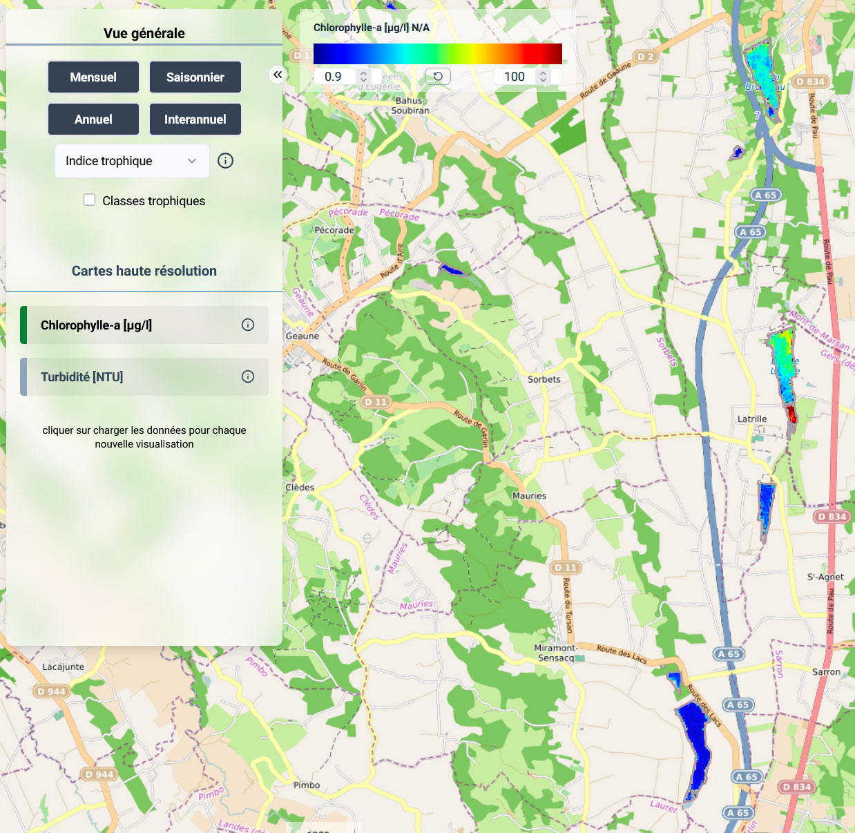
The XtremQuality web service is freely available here: https://xtremquality.magellium.fr/. It allows users to identify the flow paths of individual reservoirs as well as groups of reservoirs.
👉 This service brings three major innovations:
- To have access to instantaneous descriptive variables for an individual reservoir or for an aggregation of reservoirs, for which in the vast majority of cases, no information exists: surface, turbidity and transparency levels, eutrophication levels;
- To consult the time trajectory of these reservoirs categorized into broad classes defined from the evolution of all the reservoirs in the region;
- To identify their vulnerability to drought hazards through an indicator taking into account their evolution during recent climatic episodes.
👉 The service provides a global view of catchments and each reservoir is treated as a station with statistics and indicators available at the click of a button. This service allows the analysis of spatial dependencies of groups of reservoirs and a "macro" analysis of the evolution of individual reservoirs or a sub-catchment.
|
► Example of a high-resolution chlorophyll-a map generated by satellite and available on the XTREM QUALITY website. © IRD |
|
Outlook
Starting in 2026, XtremQuality will continue as Version 2, with the same consortium expanded to include a Brazilian partner from the state of São Paulo. Building on the current demonstrator, this second phase aims to evolve into a forecasting tool that will monitor millions of small lakes in Brazil. The partners plan to integrate new satellite-derived water quality parameters as well as water temperature data from the future TRISHNA satellite mission.
References
| XtremQuality on GEO Knowledge Hub, a long lasting digital repository created by the Group on Earth Observations: https://doi.org/10.60566/beqyn-zna14 |
-
Joffre, M., Tavares, M., Roussillon, J., Dos Santos, V., Chevalier, P., Cakir, R., Martinez J.M. & Sauvage, S. (2026). A regional framework for spatio-temporal assessment of lake eutrophication using Sentinel-2/MSI imagery. Ecological Indicators, 182, 114536.
-
Tavares, M. H., Guimarães, D., Roussillon, J., Baute, V., Cucherousset, J., Boulêtreau, S., & Martinez, J. M. (2025). A framework to retrieve water quality parameters in small, optically diverse freshwater ecosystems using Sentinel-2 MSI imagery. Remote Sensing, 17(15), 2729.
-
Mauricio Cezar Rebello Cordeiro : Application of data science as a tool for monitoring water quality in reservoirs by high resolution satellite image - Thèse de l’école doctorale Sciences de l’Univers, de l’Espace et de l’Environnement – Université de Toulouse
-
Tavares, M. H., Lins, R. C., Harmel, T., Fragoso Jr, C. R., Martínez, J. M., & Motta-Marques, D. (2021). Atmospheric and sunglint correction for retrieving chlorophyll-a in a productive tropical estuarine-lagoon system using Sentinel-2 MSI imagery. ISPRS Journal of Photogrammetry and Remote Sensing 174, 215-236
- Ventura, D. L. T., Martinez, J. M., de Attayde, J. L., Martins, E. S. P. R., Brandini, N., & Moreira, L. S. (2022). Long-term series of chlorophyll-a concentration in Brazilian semiarid lakes from Modis imagery. Water, 14(3), 400.
- Aranha, T. R. B. T., Martinez, J. M., Souza, E. P., Barros, M. U., & Martins, E. S. P. (2022). Remote analysis of the chlorophyll-a concentration using Sentinel-2 MSI images in a semiarid environment in Northeastern Brazil. Water, 14(3), 451.
- Cordeiro, M. C., Martinez, J. M., & Peña-Luque, S. (2021). Automatic water detection from multidimensional hierarchical clustering for Sentinel-2 images and a comparison with Level 2A processors. Remote Sensing of Environment, 253, 112209.
Related projects
- This work is closely linked to the work carried out by the THEIA Scientific Expertise Centre "Colours of the continental waters sec".
- Some of the methods used in this project are also being developed with UNESCO as part of the "World Water Quality Portal" initiative.
- SCO VOQUALISE, Volume and water quality in SEnégal
Project News
-
13/4/2026: XtremQuality: monitoring the 90% of freshwater that nobody looks at
-
02/12/2025: XtremQuality presents its water quality monitoring solution at COP30
-
26/06/2024: Presentation of the XtremQuality project and its progress at the 13th SCO France Quarterly Meeting "Water and coastal quality"
-
28/02/2024: XtremQuality, space technology for detecting water quality