AI2Peat
All-Ireland, AI-enhanced Peatland Monitoring Platform : Combining Artificial and Human Intelligence to combat climate change at national scale
Overview
Context
Peatlands are wetland ecosystems that provide a range of important ecosystem services to society. They cover 3% of the land on Earth on all continents, yet they store double the carbon stored by all forests combined: 20% of surface land area. Peatlands also regulate water resources by storing and releasing it slowly, which helps to mitigate drought and flooding. These are among Ireland’s most important ecosystems, providing biodiversity, clean drinking water, cultural value, and the country’s largest natural carbon stores. Yet assessing peatland condition at national scale has long been a challenge: approximately 23% of Ireland is covered by peat, making traditional field-based monitoring costly, slow, and difficult to scale.
The AI2Peat solution
The specific problem addressed here is the efficient mapping and monitoring of ecological and hydrological conditions of peatland at national scale. Traditional ‘boots on the ground’ mapping or manual image analysis are too time consuming to be efficient, while in-situ instruments are sparse and yield only point-wise information.
👉 AI2Peat enables dynamic, national scale monitoring essential for Ireland’s obligations under the EU Habitats Directive (Article 17) and the EU Nature Restoration Law. With 900,000 hectares of blanket bogs and thousands of raised bogs, meeting reporting and restoration targets would be impossible without scalable technological support.
👉 The project supports the continued improvement of national greenhouse gas accounting. To date, land-use reporting has applied peatland emission factors at broad categorical levels. AI2Peat will enable the first national map providing ecology-specific peatland information, creating new opportunities for more granular GHG estimation. This could help reduce future monitoring, reporting and verification costs and support the rollout of ecosystem service certification and private financing under Ireland's Peatland Standard.
AI2Peat is funded by Taighde Éireann – Research Ireland under Grant number 22/NCF/FD/10969P (National Challenge Fund – Future Digital Challenge).
Application site(s)
Centre of Ireland
Data
Satellite
Sentinel-1
- Sentinel-2
Results - Final product(s)
The project implemented the PeatSense portal to gather and share reliable peatland condition data. Accessible to everyone by creating an account on the website https://ai2peat.ie, it focuses on delivering AI-powered, on-demand geospatial intelligence at any spatio-temporal scale.
To date, within the Republic of Ireland, AI2Peat has been mapping:
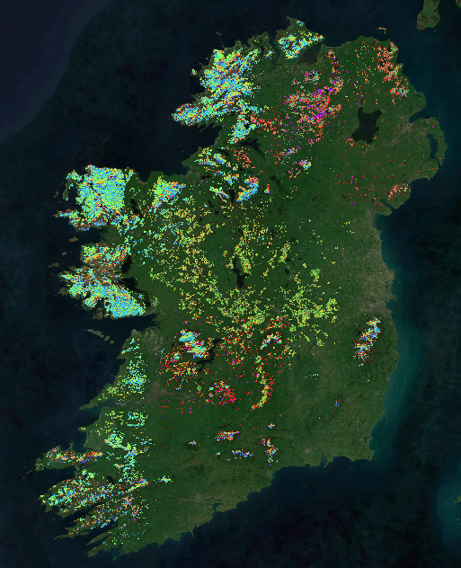
Maps covering all of Ireland:
Ecological mapping (vegetation communities) of over 3000 lowlands raised bogs, covering approximately 500 km2
Morphological mapping of peat soils, covering approximately 11,000 km2
Site-specific mapping:
Land cover mapping of peat soils (approx. 3,500 km2)
Ecological mapping (land cover) of upland blanket bogs (over 120 km2)
AI2Peat is also providing multi-temporal mapping together with change detection and, consequently, trend analysis, which is fundamental to monitor restoration progress and pressure detection, e.g. illegal turf cutting and peat-slides.
► Extent of AI2Peat mapping, Ireland (June 2026). © University College Dublin / AI2Peat
|  |
🤝 AI2Peat continuously evolves in accordance with its stakeholder needs. Current engagement with stakeholders in UK and Scandinavia (among others) will lead to new national-scale condition maps.
Valuation
AI2Peat’s work is recognised across policy, science, media, and civil society:
- Featured in RTÉ One’s “10 Things to Know About” (Season 10, Episode 1 – Surf and Turf), and in RTÉ News
- Shortlisted for the European Space Agency Sustainable Horizons Award 2025
- Highlighted by major technology and environment media TechCentral, Silicon Republic, Irish Tech News, Agriland, BusinessPlus, Irish Farmers Journal, IDA Ireland
- Presented at the National Ploughing Championship 2023, Explorium Science Centre (2024–25), and Pint of Science 2025
- Featured in SFI's Little book of Irish research (2023)
- Published on PublicPolicy.ie and showcased through PeatSense
- Finalist- AI Awards 2025: Best Application of AI in Sustainability
- Runner-up- UCD Impact Case Award
Related projects
Other ecosystems as unique as peatlands need to be closely monitored, which satellites make possible.
- SCO CARTOVEGE: Automatic mapping of habitats in the Southern Territories
- SCO AIonWetlands: Automatic mapping of Mediterranean wetlands