

ARBOCARTO-v2

Predictive mapping tool for Aedes mosquito population densities
Project completedIntended for Regional Health Agencies and private or public mosquito control operators, the Arbocarto-V2 application is operational and available via a request form from the French Ministry of Health and Prevention. The tool generates predictive maps of the abundance of Aedes albopictus or aegypti mosquitoes in a given territory, depending on the user's choice, and allows the simulation of different prevention or control scenarios.
OVERVIEW
Aedes mosquitoes (Ae. albopictus and Ae. aegypti) are vectors of pathogenic agents that are responsible for diseases such as Chikungunya, Dengue fever and Zika. They are urban, diurnal mosquitoes that are particularly harmful in the early morning and evening. The female mosquito preferentially draws blood from humans, needing it for the maturation of her eggs, before laying them on any dry part of receptacles (usually small, whether natural or artificial). The eggs hatch into larvae when the receptacles are immersed by rain or watering of plants. In addition, adult mosquitoes feed and rest in vegetation.
With the globalisation of trade and global warming, Ae. albopictus in particular, commonly known as the "tiger mosquito", which initially came from South-East Asia, has spread to Europe in recent decades and has been able to "acclimatise" to our latitudes: by putting the eggs into hibernation in winter, for example – the so-called diapause.
In response to the growing epidemiological risk, the French Ministry of Health wished to finance the development of a demonstrator for predictive mapping of the population densities of Aedes vectors (Ae. albopictus and Ae. aegypti) on a suitable spatial scale for organising surveillance and control actions based on local entomological, meteorological and remote sensing data with high and very high spatial resolution, to determine land use (green belt, type of urbanisation). The maps produced by the tool make it possible to target, as a priority, places where there is a risk of abundance of mosquitoes, in order to guide social mobilisation measures for vector control and to adapt the actions of field teams to the conditions of neighbourhoods at risk. The predictions made by ARBOCARTO can be integrated into the national server of the Ministry of Health to be cross-referenced with epidemiological and entomological field data.
The ARBOCARTO-V1 project (2018-2019) was part of the framework cooperation agreement signed by the Directorate General of Health (DGS), the Armed Forces Health Service and CNES, the French Space Agency. The ARBOCARTO-V1 demonstrator has been developed by a Consortium which includes the Rhône-Alpes Interdepartmental Agreement for Mosquito Control (EID), EID-Atlantique, EID-Méditerranée, the Regional Health Agencies (ARS) of Nouvelle Aquitaine, Auvergne Rhône-Alpes, Occitanie and Martinique, the regional authority of Martinique, the CIRAD, the Institute for Research for Development (IRD) and Marie Demarchi, a freelance professional working at the Maison de la Télédétection. ARBOCARTO follows on from numerous research projects, particularly those carried out by CIRAD, and the operational tools developed as part of the Life project "Remote sensing and Anticipation» between 2009 and 2013 for EID Méditerranée and also the Alborun project developed for the Regional Health Agency of Reunion Island.
ARBOCARTO is a scalable application that can be easily configured. ARBOCARTO-V1 already offers a simple interface, and accompanying tools (user manual, training kit (consisting of test data sets and training materials: presentation of the project and concepts + support for practical work). It works on office workstations with the only software constraint being the prior installation of JAVA 8.
Thanks to the adaptations made for ARBOCARTO-V2, the tool can now be uses in all geographical contexts for the two species, Ae. aegypti, and Ae. albopictus, whether or not they are diapausant. In addition, new functionalities have been added (integration of new vector control scenarios) and optimised (geographical management, calculation time, management of input data formatting).
|
The tool requires the daily input of updated meteorological data and environmental information to ensure the relevance of the predicted location of the mosquitoes. SCO ARBOCARTO-V2 project has produced a methodological guide to provide all the keys for non-specialists in geomatics and remote sensing, to enable them to integrate available environmental data into Arbocarto in a context of open data. |
|
Application site(s)
ARBOCARTO V2 can be used by health authorities in all regions that have already been colonized by Ae. albopictus and Ae. aegypti mosquitoes in mainland France and its overseas regions. Tests concerning the production of partial updates of environmental data and comparison of the models produced from various datasets, were carried out on:
- Montpellier and its region
- Grenoble and its region
- Bordeaux
- Reunion Island
- Mayotte
- French West Indies
DATA
Satellite
- SPOT6/7
- Sentinel-2
Other
- Land-use data: Urban Atlas, land-use produced by CES OSO, IGN (OCS GE)
- Open data: OpenStreetMap
- IRIS breakdown (INSEE – IGN)
- Meteorological data: daily rainfall and temperatures (Météo France)
RESULTS - FINAL PRODUCTS
- ARBOCARTO application, new version V2: optimisation of certain functionalities, improvement of the ergonomics of the parameterisation windows and integration of new vector control scenarios.
 |
 |
 |
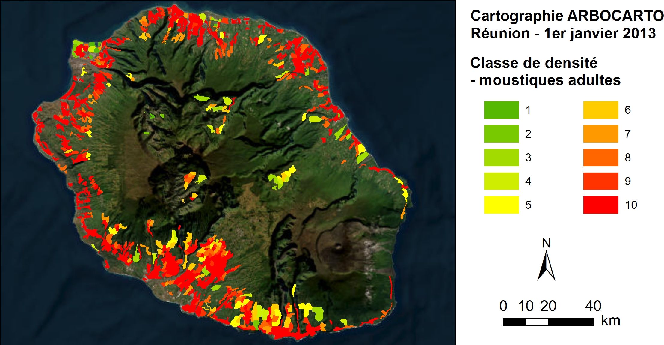 |
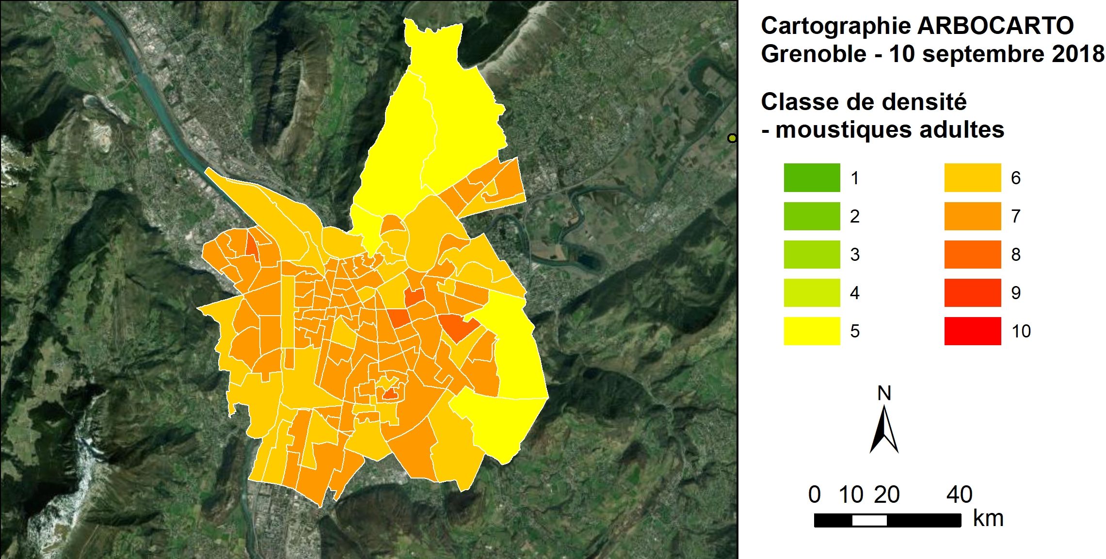
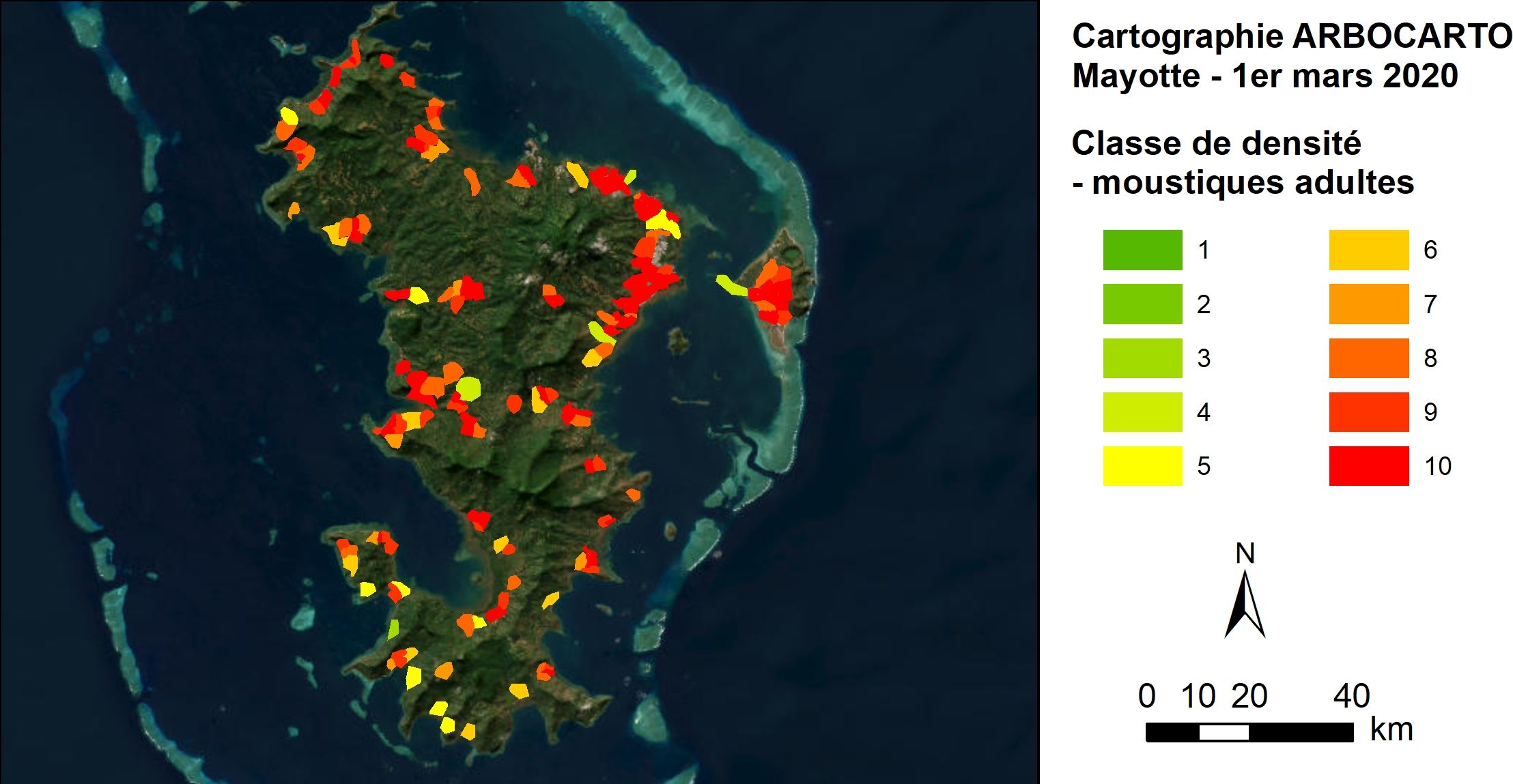
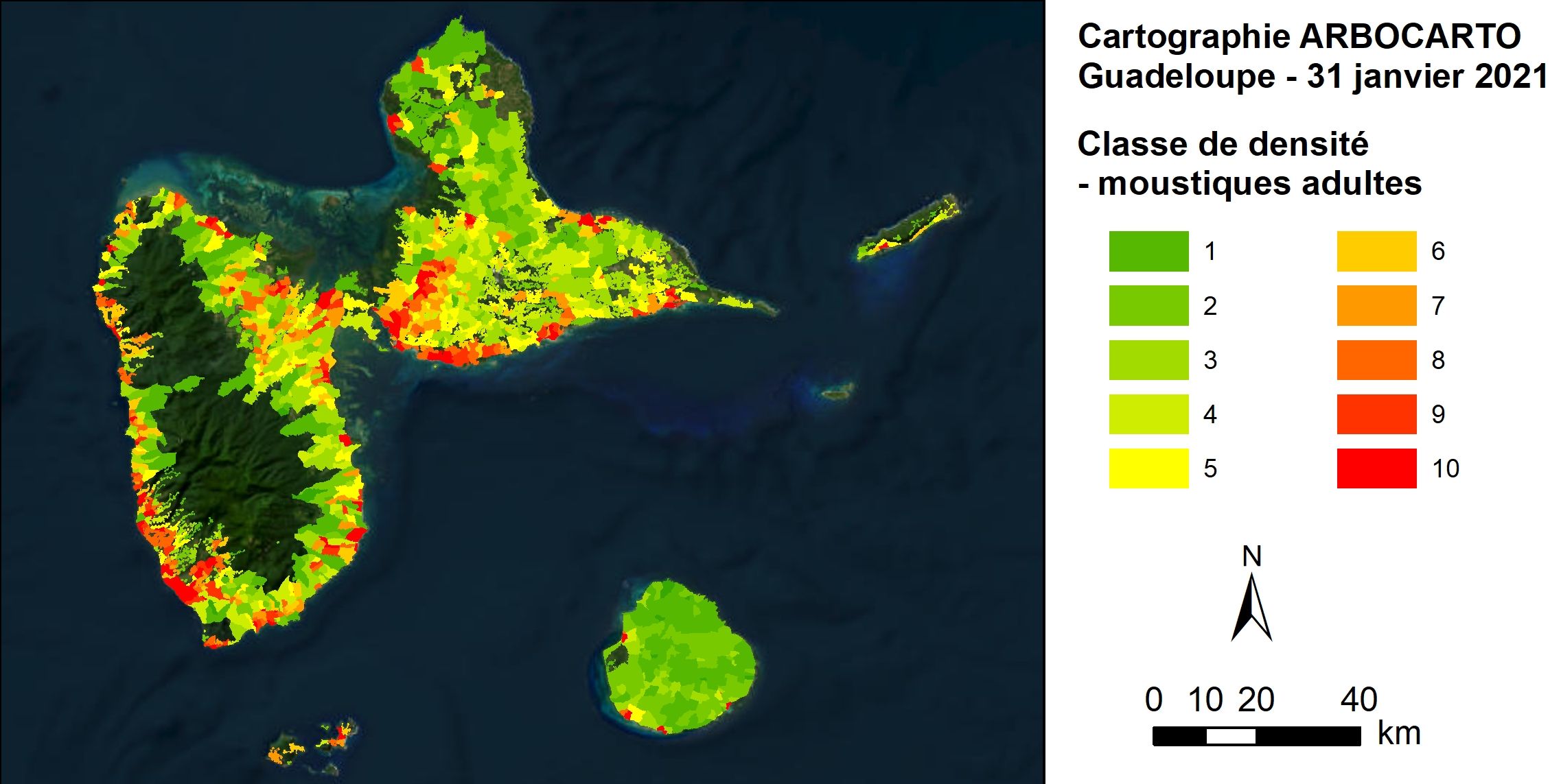
Examples of output from the ARBOCARTO tool: simulation of adult Aedes albopictus mosquito densities in experimental areas. From green, low density areas, to red, high density areas. © Arbocarto
- Free access to the application: Arbocarto is a software in .exe format, which can be requested from the Ministry of Health, owner of the tool, via the form available here (in French). The latter implies a commitment to provide feedback to the French Ministry of Health once a year.
- Update of the user manual and creation of a methodological guide for health actors concerning the creation or updating of environmental data from satellite images. These documents can be downloaded in French and English in the Resources section below.
💡Good to know: An agreement with the Ministry of Health and Météo-France allows users (ARS and mosquito control operators) to retrieve local data at the frequency they wish.
- Creation of the website www.arbocarto.fr
References
| Arbocarto V2 on GEO Knowledge Hub, a long lasting digital repository created by the Group on Earth Observations: https://doi.org/10.60566/dckq9-7p159 |
- Publication: “REMOTE SENSING AND SPATIAL MODELING - Applications to the surveillance and control of mosquito-borne diseases” published by Éditions Quae. Available in French and English. Free digital versions available at Quae.com.
Project News
-
🎥 24/02/2026: Presentation of the Arbocarto project at the 3rd ClimateSCOpe “From space to health”
-
23/05/2024: Arbocarto opens an online version, GUS unveils itself, presentation of the 2 SCO projects at the Theia "Remote Sensing, Modelling, Health & Environment"workshop
-
27/11/2023: When SCO's health projects become references, we zoom in on ClimHealth, selected by the WMO as a case study for its report ahead of COP28, and Arbocarto, identified by the French COVARS for the fight against arboviroses.
-
05/12/202 : Aedes take care! the interview of the Arbocarto-V2 project leaders to decipher its history, its implementation and its perspectives
-
June 2022: A workshop-day for the restitution of the ARBOCARTO-V2 project is organised on Thursday 30 June at the Maison de la Télédétection in Montpellier.
-
May 2022: Scientific communication - presentation of ARBOCARTO at the Living Planet Symposium in Bonn
-
May 2022: Scientific communication - presentation of ARBOCARTO at the 5th International Workshop on the Tiger Mosquito, Aedes albopictus, in Montpellier from 11 to 13 May
-
April 2022: User training sessions. Three initial training sessions on the ARBOCARTO-V2 tool (beta version) were organised in April-May 2022 for users from the Regional Health Agencies and Interdepartmental Mosquito Control Agencies.) Their feedback between the training and the end of the project will help finalise V2.
-
March 2022: MedInTechs Exhibition - Presentation of the ARBOCARTO tool during a round table led by CNES "Space, a driver of innovation in health
-
February 2022: Publication of an Arbocarto usage sheet on the Applisata website dedicated to all public users of satellite images and their partners.
-
April 2021: the website www.arbocarto.fr is online! Currently being finalized, Arbocarto-V2 will be available mid-2022, with user training
-
25/10/2021: Remote epidemiological monitoring: feedback on the 2nd Quarterly of the SCO France