

BioEOS

|
|
|
Overview
With a temporally stabilising effect on ecosystem functions, biodiversity is a natural capital that delivers important services and benefits to humanity ranging from food needs to cultural heritage. However, species are disappearing at a rate 100 to 1000 times higher than the natural rate. In Europe, only 17% of habitats and species and 11% of key ecosystems protected by EU legislation are in a satisfactory state. The challenges are posed at various levels: restoring or maintaining ecosystem functionality, economic viability, integrated management of uses and spatial planning, and taking account of more or less reversible alterations to ecosystems (e.g. climate change) in resource management. Among the main knowledge needs identified (Mongruel et al. 2019), some are related to coastal ecosystems. The latter contain an exceptional biodiversity that gives France a particular responsibility, including vis-à-vis the international community. However, they are considered to be among the most vulnerable because they are the most exposed to anthropogenic pressures, whose impacts are cumulative.
Threatened with collapse by 2050, coral reefs are indeed among the most productive ecosystems, but also among the most threatened. The latest global biodiversity assessment by IPBES (Intergovernmental Science-Policy Platform on Biodiversity and Ecosystem Services) in 2019 indicates that living coral cover has declined by almost 50% since 1870. Despite their vast surface area, estimated at 300,000 km2 across the globe, seagrass beds are among the most poorly understood coastal ecosystems. Assessing their health status over time remains difficult due to very limited monitoring data. Most of the overseas territories are home to sea grass beds showing major signs of degradation (Ifrecor, 2021).
Many biodiversity assessments are based on species inventories and the effort to identify all the species present in a region can be considerable, particularly in the aim is to describe and characterise the distribution of species on a large scale. Based on data acquisition on point or along transect, most approaches can only provide a limited insight into the spatial distribution pattern of biodiversity. From associated changes in species composition to environmental gradients, there is a real need for simple, integrative and operational indicators with the capacity to distinguish the effects of direct and indirect pressures. Satellite imagery can provide some answers.
Objectives
BioEOS thus proposes to develop observation tools to acquire reliable and relevant data that reflect the spatio-temporal variability of biodiversity on a large scale, mainly using remote sensing images. More specifically, BioEOS has the following objectives:
- Characterising spatiotemporal dynamics of biodiversity by analysing the time series of multisensor satellite images, particularly Pleiades and Sentinel. The processing of these images will be enriched by the integration of in situ observations accessible via monitoring networks and national as well as global referenced databases.
- Mapping changes and producing indicators to account for the impact of global changes on spatio-temporal dynamics of coastal biodiversity status. In addition to the need for related ecological indicators to anthropogenic pressures, the detection of sudden changes following specific events (cyclones, heat waves, changes in water salinity, changes in sea level, geological events) is also a key issue for the various regional and national stakeholders involved in large-scale monitoring of coastal areas.
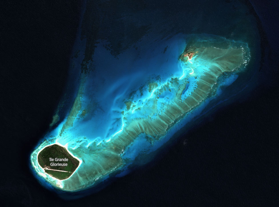
Example of a Sentinel-2 image acquired in August 2022 over the Glorieuses (Indian Ocean). © Contains modified Copernicus Sentinel data 2022 processed by Sentinel Hub
The ambition of BioEOS is to provide generic information that could be used to meet a variety of needs and objectives such as: (i) the assessment of the status of coral reefs, a complex ecosystem with multiple transitions depending on the factors of pressures on it, (ii) the monitoring of the extent and structure of seagrass beds as a bio-indicator of water quality, or (iii) the geomorphological dynamics of the seabed as important information to determine changes in coastal habitats in general.
BioEOS benefits from the institutional support of CNES, General Secretariat for Regional Affairs (SGAR) via DEAL (French department of the environment, planning and housing) of Réunion, OFB, TAAF (Terres Australes et Antarctiques Françaises, French Southern and Antarctic Territories) and RNMR (Natural Marine Reserve of Reunion Island).
Application site(s)
South West Indian Ocean Region:
- Territory 1 : The Reunion Island, France
- Territory 2 : Glorious Islands, France
- Territory 3 : Mayotte, France
- Territory 4 : Bassas da India, France
Because global species extinctions are about 60 times higher in the French overseas departments and territories than in mainland France (Gargominy, 2003), BioEOS is focusing on the South-West Indian Ocean region to set up a coastal biodiversity monitoring demonstrator. In addition to the interest in the vulnerable ecosystems of this region (e.g. coral reefs, mangroves, seagrass beds), such an area also presents a gradient of anthropic pressure, the Eparses islands being considered as free of direct human pressure. For this demonstrator, a set of parameters and proxies (estimation of a variable that cannot be measured directly) of biodiversity ecological status will be extracted from the data collected on the pilot sites. The processing chains will be based mainly on image processing and machine learning algorithms proven by the scientific community.
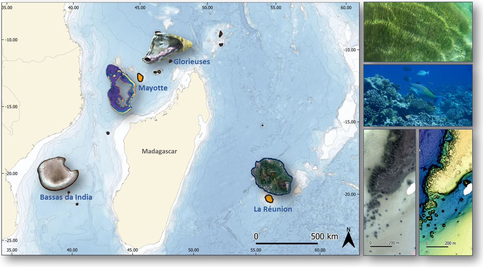
Pilot sites for the implementation of the BioEOS demonstrator (left) and targeted ecosystems for developing biodiversity monitoring indicators (seagrass beds, coral reefs, and seabed geomorphology) (right). © T. Bajjouk (illustration), B. Brisset (coral reef photo) & M. Contini (seagrass photo)
Data
Satellite
High spatial and temporal resolution radar and multispectral images:
- Pléiades;
- Copernicus Sentinel Constellation;
- PRISMA.
Other
-
In situ observations of monitoring networks and regional, national (BD Recif, REPHY, scientific cruises, data from the Mayotte Marine Natural Park, etc.) or international databases;
-
Data acquired with the surfboard equipped with acoustic and optical sensors developed in the framework of the INTEREG IoT (Indian Ocean Turtle) project coordinated by Ifremer.
Results – Final product(s)
Ultimately, it is the metrics characterising biodiversity spatially that will be sought. The products can be classified into two categories:
- Elementary products such as image time series from multi-sensor fusion, habitat maps, species distribution, spectral indices, geomorphological indices and any other individual metrics that can be used to construct indicators,
- Aggregated products, directly usable by end-users as biodiversity assessment and monitoring indicators (e.g. coral vitality, beta diversity), adapted from the state of the art or newly constructed by BioEOS.
References
• Gargominy O. (Ed.) 2003. Biodiversité et conservation dans les collectivités françaises d’outre-mer. Collection Planète Nature. Comité français pour l’UICN, Paris, France. x et 246 pp.
• Ifrecor, 2021. Etat de santé des récifs coralliens, herbiers marins et mangroves des outre-mer français. Bilan 2020. 335 p.
• IPBES (2019): Summary for policymakers of the global assessment report on biodiversity and ecosystem services of the Intergovernmental Science-Policy Platform on Biodiversity and Ecosystem Services. IPBES secretariat, Bonn, Germany. 56 p.
• Mongruel R. et al. (2019). Milieux marins et littoraux : évaluation des écosystèmes et des services rendus. Report of the study conducted for the EFESE program.
Related project(s)
-
INTEREG IoT, project coordinated by IFREMER, whose data acquired using acoustic and optical sensors will feed BioEOS
-
SCO :
- 🇵🇭 CopPhil-BlueHab : Benthic habitat observation for climate-related impacts and monitoring in the Philippines
- 🇫🇷 TAHATAI : Mapping and analytical service for marine spatial planning
- 🇫🇷 MangMap : Global Mangrove Monitoring Platform
- 🇬🇦 SUMAG : Mangrove monitoring platform in Gabon
Project news
-
🎥 03/12/2025: Presentation of the BioEOS project and its progress at the 19th Quarterly Meeting of SCO France
-
11/04/2024: A tailor-made campaign for BioEOS
- 27/07/2023: BioEOS, a project for coastal biodiversity, the project kick-off meeting