

MANGROVES

Project completedThe Mangroves project has delivered MangMap, a mapping portal for operational satellite monitoring of mangroves. Aimed at scientists and institutional players working to preserve and enhance this ecosystem, MangMap produces, catalogs and distributes standardized, up-to-date sets of environmental information on mangroves and their dynamics. With free access, all you need to do is create a local account (or use your Theia account) to benefit from all the services offered by the platform.
Accredited with SCO label in 2025, the MangMap 2 project continues to enrich the platform with new geographical sites, new features and community engagement.
OVERVIEW
Context
On a global scale, mangrove forests occupy between 150,000 and 200,000 km2 (some 58,000 square miles and 78,000 square miles). These dynamic open ecotones, which are extremely rich in terms of biodiversity, are found in nearly three-quarters of tropical coastal areas. They perform unique ecological and environmental functions: they mitigate the impact of cataclysmic events (hurricanes, typhoons, cyclones, tsunamis); they protect against and mitigate coastal erosion (due to swells and currents); they are biotopes for abundant biodiversity (fish, crustaceans, birds, insects); they provide environments for reproduction, larval development and juvenile growth; they are biological "filters" of waters thanks to the very numerous micro-organisms they harbour; and carbon is stored in mangrove species and sequestered in the soils.
Mangroves are in fact a vital natural heritage, and their conservation is a key issue for human populations that are increasingly concentrated along coastlines, and that benefit from numerous ecosystem services.
Today, France's overseas territories are home to just under 100,000 hectares of mangrove, i.e. nearly 1,000 km2 (around 400 square miles) (source: Conservatoire du Littoral), distributed mainly between French Guiana (more than half of the French mangrove), the Pacific (New Caledonia), the West Indies (Guadeloupe, Martinique, Saint-Martin, Saint-Barthélémy), the Indian Ocean (Mayotte, the Scattered Islands) and in small proportions in Wallis and Futuna and French Polynesia. According to Ong, J.E. & Gong, W.K., 2013, it is estimated that about 25% of the world’s mangrove forests will have been destroyed by 2025.
Towards a monitoring tool
To succeed in curbing this dynamic, satellite observation instruments offer considerable advantages: they enable repeated revisit measurements over these hard-to-reach environments, with a wide range of available sensors and proven methods of processing the acquired data. France has a history of outstanding experience in the field, with expert communities organized into Skill Centres that are part of the national Data Terra research infrastructure.
The aim of the Mangroves project is to mobilize this capital to help characterize the functioning of these environments, support their management and contribute to optimizing their preservation and development through the commissioning of a platform for operational monitoring of mangroves by remote sensing, generating and disseminating qualified environmental information.
Developed by scientists in the framework of studies and research in the field (understanding coastal dynamics and the dynamics of mangrove ecosystems, monitoring of global impacts/change), the tools gathered here are intended for national and local stakeholders for land use planning and conservation, as input for management dashboards and plans and ecological zoning.
MangMap is destined to play a leading role in the development of a federative and normative approach to mangrove monitoring, guaranteeing the uniformity and interoperability of standardized products across all the territories to be considered, enabling the implementation of harmonized protocols in French territories.
Methodology
Most of the satellite data from the high to very high resolution (decametric to sub metric) optical and radar satellites required to manufacture these products are disseminated or made available by current systems (e.g. Skill Centres, DINAMIS of the Data Terra research infrastructure).
Reference methodology works (IFRECOR Methodological Guide, 2015) have been published to guide the construction of products dedicated to mangrove monitoring concerning their spatial distribution, state of maturity and growth, chlorophyll activity, vegetation height and canopy density.
In order to develop related indicators, the use or collection of additional information, or the application of other types of satellite data processing are necessary: the indicators concern species, biomass, the nature of sediments and substrates, the spatio-temporal dynamics of vegetation or hydro-sedimentary processes, detection systems or even alerts about forest clearing or forest degradation, extraction of specific resources, and monitoring of resources or uses with high social value (reforestation), etc.
In this context, the effort to set up a platform for operational monitoring of mangrove forests by remote sensing required four types of activities:
- The mobilization of the stakeholders, appropriation and co-construction of the project and joint specification and design of deliverables;
- The aggregation, compilation, takeover/adaptation of existing software tools and resources;
- Complementary methodological and thematic developments to be produced and qualified;
- The construction and online implementation of an operational tool for the production and dissemination of geo-information and services.
After a preliminary phase of analysis of the state of the art in the field, which will include determining specific expectations, prototyping and qualification, the tool has been integrated into the Data Terra shared infrastructure network.
Application site(s)
- French Guiana
- Martinique
- Guadeloupe
- Mayotte, Scattered Islands
- French Polynesia
- New Caledonia
- Madagascar
- By extension, any territory sheltering mangrove forests.
DATA
Satellite
The platform is based on Sentinel-2 image series from 2018 to the present day. Eventually, depending on the progress of related R&D projects led by IRD, other data and products derived from these data may be integrated into MangMap, in all or part of some of the sites monitored: Sentinel-1, Spot 6-7, Pleiades.
Geographical information
Reference datasets were mobilized and worked on to train image classification models: reference vectors of mangroves monitored by MangMap, supplied by project partners or obtained and improved from other existing platforms.
Other
In a subsequent development phase, the MangMap project hopes to work more closely with partners from sites monitored by the Platform, with a view to producing territorialized indicators specifically calibrated to provide information on processes affecting mangroves locally: monitoring silkworm cultivation or wild honey production, for example. In this context, data collected in situ describing either the state of the environment or the practices used to harvest natural resources of interest could be integrated into the Platform.
RESULTS - FINAL PRODUCTS
👉 MangMap, a mapping portal for operational satellite monitoring of mangroves to help optimize their preservation and enhancement.
This first release in demo mode focuses on 5 sites: Madagascar (Bombetoka Bay), New Caledonia (West Coast North Province), Djibouti (East coast Obock district), Senegal (South coast) and French Guiana (Coast Cayenne - Kourou).
In this first version, access to the platform, its images and products is free. However, calling up services on demand requires the creation of a MangMap account (via an online form available from the platform), with the exception of Theia users who can use their Theia account.
|
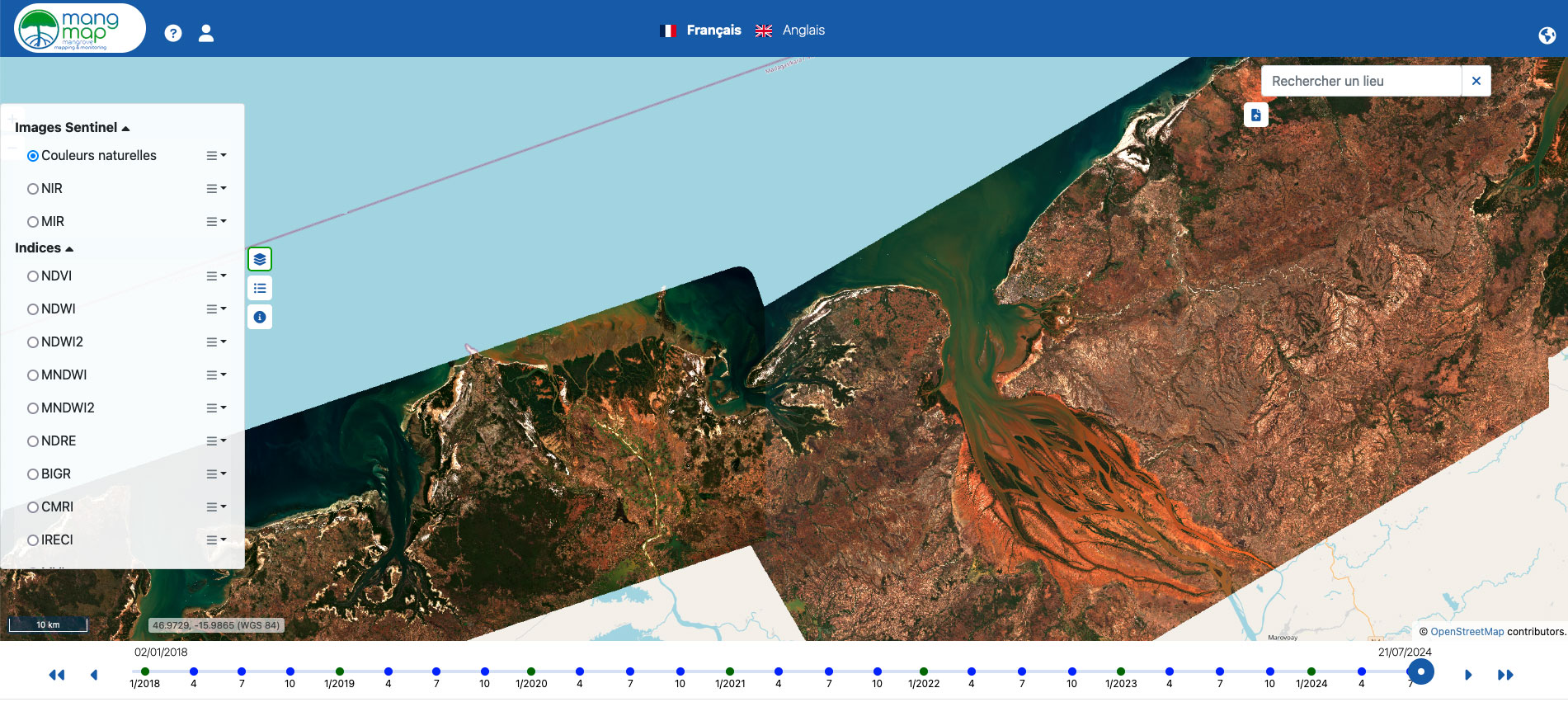
▲Sentinel-2 tile from Bombetoka Bay (Madagascar). © MangMap |
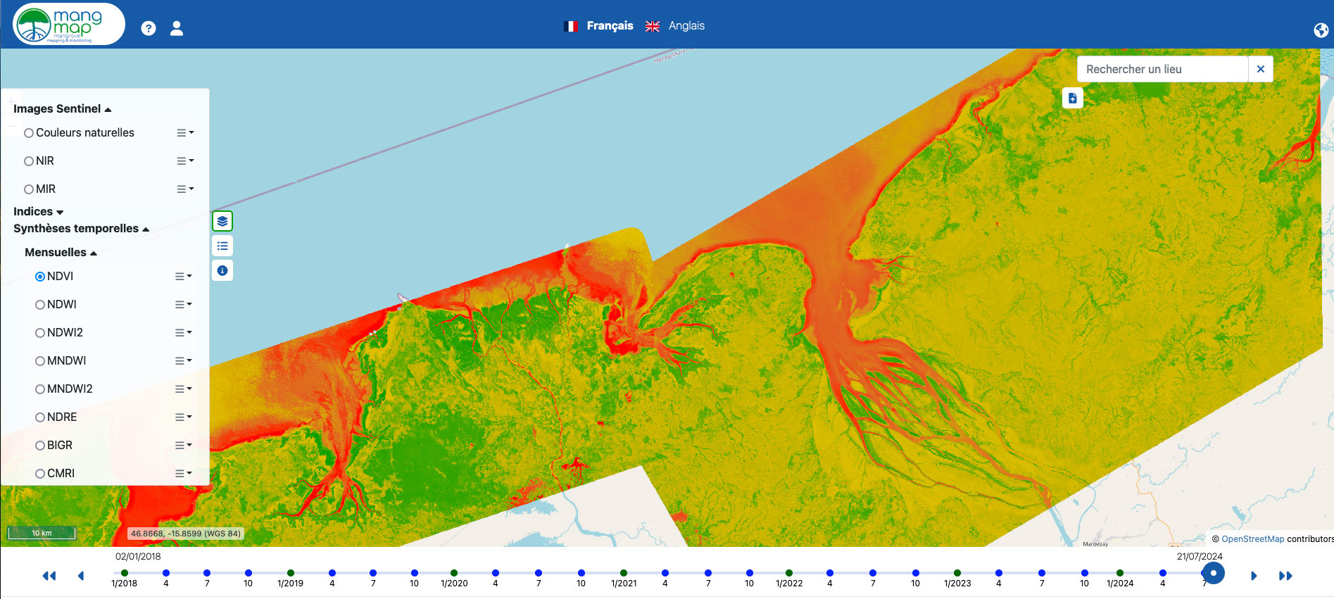
▲Monthly synthesis of NDVI moisture index in Bombetoka Bay (Madagascar). © MangMap |
The platform enables the following products to be viewed online and downloaded:
- Sentinel-2 level 2A satellite images, 13 spectral bands in visible and near-infrared light with spatial resolution between 10 and 60 meters, updated every 5 days,
- 11 spectral indices, raster format, 10 m spatial resolution: NDVI, NDWI, NDWI2, MNDWI, MNDWI2, NDRE, BIGR, CMRI, IRECI, MVI, SAVI calculated for each new Sentinel2 L2A image,
- Mangrove contour vector, proposed quarterly,
- Temporal summaries (monthly, quarterly, half-yearly and annual) for the 11 spectral index rasters.
The platform offers on-demand services for users who can launch calculations in a downloaded or screen-entered area of interest (polygon or transect), for a selected time period:
- Calculation of differences from date to date or between index time summaries
- Calculation of statistics: temporal evolution of index values (mean, quantiles and standard deviation)
- Vector difference calculation: estimation of the spatial evolution of the mangrove between 2 dates.
👉 The platform is accompanied by a comprehensive website, https://mangmap.org, which presents the project in its entirety and makes available all reference documents, guides and manuals.
OUTLOOK
After applying for the annual call for projects, the Mangroves team received the SCO label in 2025 to continue developing the platform through the MangMap 2 project, focusing on three priorities:
- Geographical expansion with the integration of at least the 11 additional sites planned in the initial project roadmap.
- Acculturation, facilitation and training of the ‘MangMap network’ user community.
- Thematic and technical developments to offer new online services and improve the platform's user-friendliness.
References
| Mangroves on GEO Knowledge Hub, a long lasting digital repository created by the Group on Earth Observations: https://doi.org/10.60566/cdrzc-vrm75 |
-
Dodd, R. S. and J. E. Ong. 2008. Future of mangrove systems to 2025. Pp. 172–187, In: N. V. C. Polunin (ed.), Aquatic ecosystems: Trends and global prospects. Cambridge: Cambridge University Press
-
Ong, J.E. & Gong, W.K. (2013). Structure, Function and Management of Mangrove Ecosystems. ISME Mangrove Educational Book Series No. 2. International Society for Mangrove Ecosystems (ISME), Okinawa, Japan, and International Tropical Timber Organization (ITTO), Yokohama, Japan
Related project(s)
SCO MangMap 2, the sequel to Mangroves
SCO SUMAG, mangrove monitoring platform in Gabon
Project news
-
16/12/2024: MangMap, the satellite platform for monitoring mangroves, is now open
-
20/12/2022: Presentation of Mangroves project and its progress during the 7th SCO France Quarterly Meeting dedicated to SCO in the Pacific & Indian Oceans.
- 21/06/2022: How about Mangroves? Progress of the project at mid-term