

CAHYSPA

Central Asia HYdrology from SPAce
Overview
Context
Central Asia is made up of five countries (Kazakhstan, Kyrgyzstan, Tajikistan, Uzbekistan and Turkmenistan) that share water resources through several major rivers, all of which have their source in the Pamir and Tien Shan mountains. Among these rivers, the Syr Daria is a transboundary river characterized by the fact that two upstream countries (Kyrgyzstan and Tajikistan) receive a large quantity of water, while the two downstream countries (Kazakhstan and Uzbekistan), located in arid regions with extremely low rainfall (less than 100 mm per year over the Aral Sea, for example), depend entirely on the water redistributed in the watershed by the rivers.
Before the collapse of the Soviet Union, water management for Central Asia's rivers was centralized in Moscow. After 1991, the rivers became transboundary, with diverging interests between the riparian countries. Consequently, water management had to be redefined in this geopolitical context. Today, decisions must be taken collectively within a cross-border framework, with quotas allocated and reservoirs regulated to serve the interests of each country in a concerted and cooperative manner, as defined in various conventions and political agreements signed by the parties.
In summary, along the Syr Daria, Kyrgyzstan and Tajikistan are required to store water in the large reservoirs (Toktogul and Karaikum) during the winter months and release water in spring and summer for irrigation in Kazakhstan and Uzbekistan. However, the need for energy production in upstream (poorer) countries may lead them to release water in winter for hydroelectric generation. Given that the storage capacity of downstream reservoirs such as Chardarya and Karaikum is almost 10 times less than that of the upstream reservoir (Toktogul), this can lead to river overflows and major flooding of flood plains such as the Arnasay in Uzbekistan. To effectively organize water management along the Syr Daria, it is therefore essential to set up tools for the transparent exchange of basic information such as water levels and flows along the river and its tributaries, water stored and released in reservoirs, and the amount of water needed and used for irrigation.
Objectives
🎯 The Central Asia Hydrology from Space (CAHYSPA) project aims to develop a center of expertise in Central Asia for Earth Observation (EO) processing and analysis, dedicated to the operational monitoring of surface waters along the Syr Daria River.
Moreover, Central Asia's surface waters are impacted by, and vulnerable to, global warming. A recent study showed that, over the last 80 years, 80% of the decline in the flow of the Syr Daria was due to increased irrigation and around 20% to the warming observed over this period. A recent report by the Asian Development Bank concludes that water loss in Central Asian river basins will increase significantly over the coming decades as a result of climate change. However, there are still major uncertainties about future trends, with climate projections showing that rainfall fluctuations will vary between -5 and +10%.
The work proposed in this project involves generating several key variables from direct Earth observations (EO) and assimilating these observations into the MGB hydrological model for flow estimation, as is done by other ongoing SCO projects on other river basins (such as OpHySE for the Maroni River in French Guiana and OpHySE-MOCHA on East African rivers). MGB is a rainfall-runoff model widely used for tropical rivers, but additional modules for snowpack contribution are under development and will be used for the Syr Daria. Flow estimates on several time scales, based on predictions from the European Centre for Medium-Range Weather Forecasts (ECMWF), will be produced, and these flow estimates will also be compared with SWOT flow products from the HiVDI model and validated by in situ measurements.
🎯 Another key objective of the project is to better understand and model the connectivity between rivers and reservoirs. Rivers and lakes are both integral components of the global drainage system. Although practically separated into "lotic" and "lentic" units due to their differences in residence time and flow velocity, rivers and lakes are intrinsically connected by complex interfaces that are rarely clear or stationary. Instead, the so-called "lotic-lentic divide" often represents a continuum where hydraulic properties, as well as associated sedimentary and biogeochemical processes, gradually transition between the two systems.
The leader of this project (J-F Cretaux) is also a key contributor to an American project (LaRiC, Lake River Continuum), aimed at bringing lake and river sciences closer together, in particular through the use of SWOT data. This project is funded under the NASA ROSES program for the SWOT science team. The LaRiC project aims to better calculate the flow of rivers cut by artificial reservoirs and to quantify how reservoirs respond to changes in their inflows, which can be used to decipher reservoir functioning and quantify water-related services.
Methology
|
A pre-study was carried out at LEGOS (credits Julien Lefebve) using precipitation data sets (around twenty data sets were used), evapotranspiration grids and outputs of water stock variations gridded with GRACE measurements (gravimetry). All these data were pre-processed and formatted at LEGOS (credits: Alejandro Blazquez, CNES/Legos). According to this pre-study, water stocks in the basin clearly show a decrease coupled with a multiannual cycle of around 6 years (see opposite figure). |
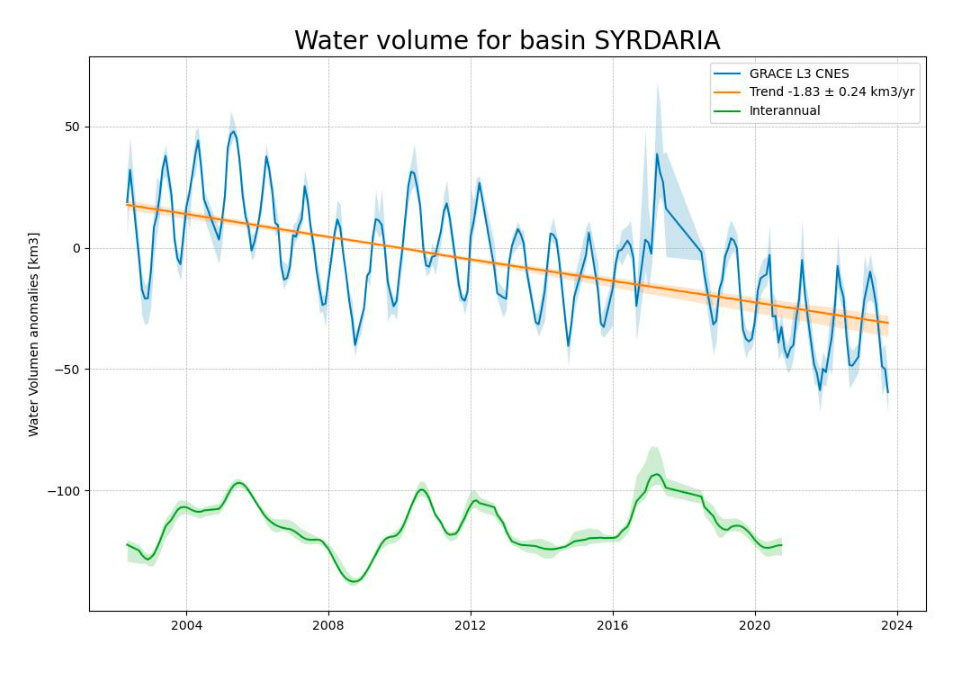
▲ Variation in water stocks in the Syr Darya basin measured by GRACE over the last 20 years. © Julien Lefebve, CNES, LEGOS |
Studies to complement this initial result will be developed over the course of the project. They will be organized into 4 work packages:
WP1 - Bibliographical review and expression of needs (LEGOS and EnviroVision main tasks)
- Bibliographical review and choice of indicators and events to be analyzed, choice of necessary and appropriate modeling.
- Survey of users already identified (universities, basin managers, water ministry) of needs in terms of content and information sharing.
- Establish a roadmap for the rest of the project: what type of data to produce, how to produce it, how to validate it, how to make it available to identified users?
The points listed above will be the subject of a preliminary report to be submitted to local stakeholders.
WP2 - Product evaluation (shared task Legos, Hydromatters, Kazhydromet)
- Levels, surfaces, based on altimetry and optical missions (Sentinel, SWOT) and comparison/consistency with in situ.
- Precipitation (GPM in particular, and comparisons with in situ).
- Meteorological variables (ECMWF & in situ).
- Other relevant data identified by partners and detailed in the needs assessment report.
- Flows (SWOT, MGB, in situ).
At the end of WP2, we will organize a campaign on the river in spring 2026 (conditioned by actual navigation possibilities) to collect all the information needed to run the models, but also to validate the satellite data: bathymetry on several sections, water level, flows, river width.
WP3 - Development (mainly carried out by Hydromatters and the University of Illinois, under the supervision of LEGOS and EnviroVision)
- Implementation of a relevant MGB run with existing in situ data, depending on the availability/quality of input data.
- Calculation of rating curves using several methods and in conjunction with existing and/or historical in situ data/stations.
- Comparison of MGB model outputs and the SWOT flow product (to be provided by the project).
- Regionalization of the LaRiC project (in conjunction with the University of Illinois) on the measurement of inlets/outlets of artificial reservoirs and impact on flow measurements.
- Setting up a platform for visualizing and making available project data.
WP4 - Reports provided by LEGOS
- Needs study at the end of the evaluation with partners, which may be broken down into two sub-sections "data" and "indicators".
- Validation report at the end of the first year of the project: inter-validation of study products (SWOT, simulated flows, LaRic etc.) and quality indicators (by comparison with in situ data).
- Final report at the end of the project: conclusions of the study and proposal for transposition to other basins.
Application site(s)
|
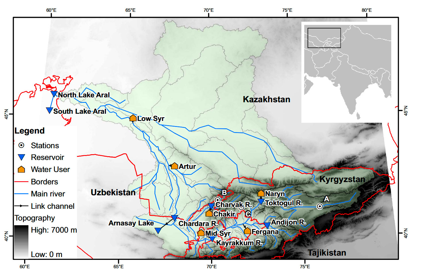
Syr-Daria watershed. The countries through which the river flows are Kyrgyzstan, Tajikistan, Uzbekistan and Kazakhstan.
► Syr-Daria basin, main rivers (blue line) and political borders (red lines). Adapted from Pereira-Cardenal et al., 2011, ESSD. |
 |
Data
Satellite
- Nadir altimetry: Sentinel-3 and 6, Jason (1,2,3), Topex / Poseidon, Envisat
- Interferometry: SWOT
- Gravimetry: GRACE
Other
- In situ on Syr Darya flows, precipitation, reservoir levels (data from field campaigns to be carried out during the two years of the project to complete the in-situ datasets)
- ECMWF global weather grids, precipitation data grids (LEGOS FROGGS database based on some twenty rainfall products)
- Evapo-transpiration model output
Results – Final product(s)
-
The study consists in extracting from satellite data the information (hydrological variables) essential for:
-
Understand the water cycle at the scale of the Syr Darya basin
-
Produce higher-level variables (flows, stocks) and map them on the hydrographic network
-
Assimilate them in models (MGB, HiVDI) produced by Hydromatters and validate them with in situ data, either from existing networks (in partnership with regional institutes) or from dedicated campaigns in the basin (carried out by all partners).
-
Set up an operational service for hydrological monitoring of the basin using satellite data (including SWOT).
-
Understand the role of reservoirs and their management in water availability for cross-border management applications. This study will be carried out largely in conjunction with the University of Illinois and the LaRiC project funded as part of a NASA project for SWOT.
-
-
Inter-comparison of the hydrological models available to us for the Syr Darya basin (MGB, HiVDI and LaRiC).
-
Drafting of a roadmap for the implementation of a monitoring strategy in line with regional needs, and identification of a model for transposition to other basins of the same type, notably in Central Asia.
References
- Wang, J., Pottier, C., Cazals, C., Battude, M., Sheng, Y., Song, C., […] Cretaux J-F et al. (2025). The Surface Water Ocean Topography mission (SWOT) Prior Lake Database (PLD): Lake mask and operational auxiliaries. Water Resources Research, 61, e2023WR036896. https://doi.org/10.1029/ 2023WR036896
- Moreira D., Papa F., Fassoni-Andrade A., Fleischmann A., Wongchuig S., Paiva R., Paris A., Frappart F., Santos Melo J., Crétaux J-F., Martinelli Santos A., Garambois P-A., Kitambo B., and Calmant S., 2025. Widespread and Exceptional Reduction in River Water Levels Across the Amazon Basin during the 2023 Extreme Drought Revealed by Satellite Altimetry, GRL, in press
- Gbetkom P., Cretaux J-F., Biancamaria S, Blazquez A, Gosset M, Paris A, Tchilibou M, Laetitia Gal L, Kitambo B, Jucá Oliveira R-A. 2024, Lake Tanganyika basin water storage variations analysis over 2003-2021 for water balance monitoring and flood study. Remote Sensing Applications: Society and Environment, 34, 101182, ISSN 2352-9385, https://doi.org/10.1016/j.rsase.2024.101182.
- F Xu., G. Zhang., R.I.Woolway., K. Yang., Y. Wada., J. Wang., and J-F Cretaux, 2024. Continuous lake expansion threatens living environment of Tibetan Plateau, Nat. Geosci. (2024). https://doi.org/10.1038/s41561-024-01446-w
- Fu, L.‐L., Pavelsky, T., Cretaux, J.‐F., Morrow, R., Farrar, J. T., Vaze, P., et al. (2024). The Surface Water and Ocean Topography Mission: A breakthrough in radar remote sensing of the ocean and land surface water. Geophysical Research Letters, 51, e2023GL107652. https://doi.org/10.1029/2023GL107652
- Cretaux J-F, Calmant S., Papa F., Frappart F., Paris A., Berge-Nguyen M. 2023, Inland surface waters quantity monitored from remote sensing, Survey in geophysics, 44, 5, 1519-1552, https://doi.org/10.1007/s10712-023-09803-x
- Yao F., Ben Livneh B., Rajagopalan B., Wang J., Crétaux J-F., Wada Y., Berge-Nguyen M., 2023, Satellites reveal widespread decline in global lake water storage Science, 380, 743-749, 2023
- Wang J., Walter B.A., Yao F., Song C., Ding M., Maroof A.S., Zhu J., Fan C., McAlister J.M., Sikder S., Sheng Y., Allen G.H., Cretaux J6f., and Wada Y., 2022,. GeoDAR: georeferenced global dams and reservoirs dataset for bridging attributes and geolocations. Earth System Science Data, vol. 14, no 4, p. 1869-1899
- Yao F., Wang J., Wang C., Cretaux J-F. 2019. Constructing long-term high-frequency time series of global lake and reservoir areas using Landsat imagery, Remote Sensing of Environment, 232 (019) 1112105
- Fleischmann A., Siqueira V., Paris A., Collischonn W., Paiva R., Pontes P., Cretaux J-F., Berge-Nguyen M., Biancamaria S., Gosset M., Calmant S., Tanimoun B., 2018, On the importance of coupling hydrology and hydrodynamic models on large semi-arid wetlands: application to the Upper Niger River Basin, Journal of Hydrology, 561, 943-959
Related project(s)
- SCO OpHySE
- SCO OpHySE-MOCHA
- LaRiC (Lake River Continuum)