

OpHySE

Operational Hydrology from Space and modEls
Project completedIn 18 months of development, OpHySE will have made it possible to implement the SAGUI hydrological forecasting platform (https://sagui.hydro-matters.fr/), which includes various hydro-meteorological indicators tailored to the basins of French Guiana. This platform enables real-time monitoring of French Guiana's catchment areas using warning and/or climate change indicators: deviation of current flows from 'normal' flows over several different decades, flow warning levels at points of interest, rainfall intensity warnings and air quality. All of this is based on satellite data, converted into flow rates using a hydrological model.
OVERVIEW
Guiana is THE French territory of tropical hydrology. Covered with 90% of Amazonian forest, it is delimited in the northwest by the Maroni (border with Suriname) and in the southeast by the Oyapock (border with Brazil). These two rivers represent particularly sensitive borders, for social, political, economic and environmental reasons.
As all the road infrastructures are located on the coast, the Maroni and the Oyapock are the only means of transporting goods and people to the villages located in the upstream part of the basins. These rivers also represent the route by which illegal workers and the products of gold panning transit from or to the riparian countries, which is a factor of societal problems and diplomatic tensions.
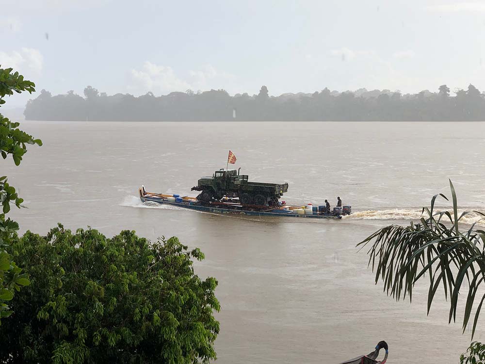
On the rivers of French Guiana, the remarkable mastery of the pirogues allows the transport of all types of goods and merchandise. © Jacques VERRON
The Amazonian context therefore makes it difficult to equip and maintain an ad hoc hydrological monitoring network, not to mention the impossibility of such monitoring for the Surinamese and Brazilian tributaries, which nevertheless represent a significant part of the water inflow to the Guiana territory. In addition to the Maroni and the Oyapock, seven rivers of more than 100 km in length cross French Guiana. One of them, the Sinnamary, through the Petit Saut dam, provides the department with an important part of its electricity, of which the Guiana Space Center (CSG) is a major user. Moreover, like the entire Amazon region, French Guiana is currently experiencing the effects of climate change. Knowing that 90% of the population lives on the coastal strip, the most unstable and mobile in the world, at less than 2 m of altitude, the changes on the rivers could endanger the populations (increased risk of flooding due to more intense extreme events, decrease in the potability of water due to more frequent saline rises because of prolonged low water levels, increased difficulty of access to health care and food, etc.) and the local biodiversity.
The OpHySE (Operational Hydrology from Space and modEls) project therefore aimed to set up a platform for real-time monitoring of river conditions and navigability in French Guiana.
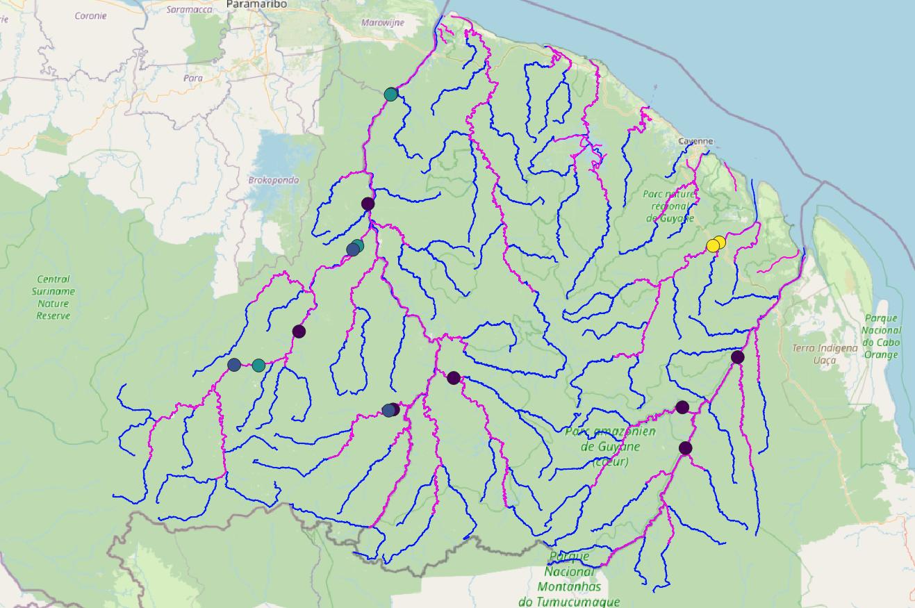
Hydrological network concerned by the project © Stéphane Calmant
Today, this platform enables real-time monitoring of the state of the basins (flow and navigability) but also analyses of climatic trends through re-analyses fed by long time series of altimetry and rainfall data. This real time information enables government and regional services, as well as civil society players, to analyze the risks linked to an excess or a lack of water in the rivers, and to plan displacements and interventions in particular.
In phase II of the project, forecasting modes could be put in place using operational hydro-meteorological forecasts or forecasts of trends in average rainfall over the 2050-2100 timeframe. It should also be noted that a coupling with the 'water quality' part (e.g. sediment load, discharge of pollutants from gold mining, etc.) and fine hydraulics could be considered in the future.
Many French hydrological actors have the ambition of a large project of development of a spatial and operational hydrology of which OpHySE is positioned as a significant step. Thus OpHySE gathered:
- laboratories and research institutes whose work feeds the platform (LEGOS, GET, INRAE Aix en Provence, CNES);
- users (DGTM, OEG, OIEau), involved in the design and validation of the platform;
- SMEs that operationalize the platform (Hydro-Matters, Magellium, CS) while others analyze the business model and develop user interfaces (WeatherForce, Pi-Geosolutions).
Methodology
The methodology used is designed to be reproducible and robust. Flows are estimated for all the catchment areas using hydrological and hydrodynamic rainfall/flow modelling (using the MGB model), the quality of which is validated using in situ data (available on the SCHAPI website or collected in the field). This real-time estimate (using the GSMAP precipitation product) is improved by an EnKF assimilation scheme for altimetric flow data. These assimilated flows are obtained from virtual stations updated in real time in Hydroweb/Theia, virtual stations whose water heights are converted into flows by means of High/Flow rating curves obtained beforehand.
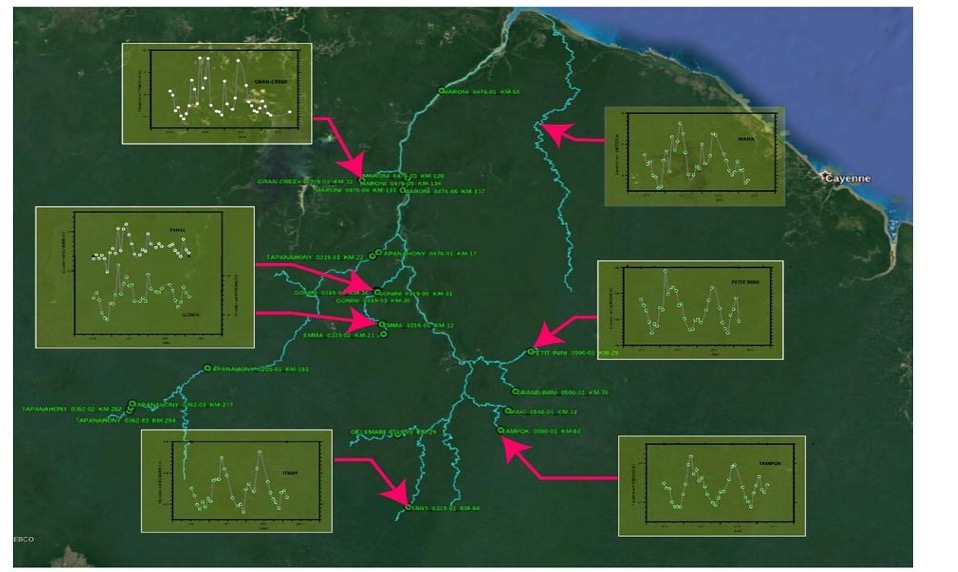
Location and quality (from yellow to blue, from 0.2 to 0.95) of the rating curves currently used in the platform, and corresponding to the series available on hydroweb with a time series long enough to calculate the rating curves. © Hydromatters
Application site(s)
French Guiana, South America
DATA
Satellite
- Jason-3
- Sentinel-3
- Sentinel-6
- Missions contributing to the GPM program, including the Franco-Indian satellite Megha-Tropiques
Others
- In-situ data acquired during the measurement campaigns, particularly bathymetry and current information , as part of the Cal/Val SWOT mission and the ESA St3TART project.
RESULTS - FINAL PRODUCTS
- SAGUI platform : https://sagui.hydro-matters.fr/
The OpHySE project makes a major contribution to the SAGUI platform, being its main provider of information and data. Thanks to this project, the hydrological status of the main catchment areas in French Guiana (Maroni, Mana, Iracoubo, Sinnamary, Kourou, Mahury, Approuague, Oyapock) is available online free of charge via the link https://sagui.hydro-matters.fr/.
The results are available on a global map with a colored representation of the state of the rivers (flows and flow anomalies - i.e., deviations from normal), and several navigation tabs providing differentiated views of the hydro-meteorological indicators flow, rain and air quality. The tabs allow you to change the variable displayed on the main screen and on the POIs (Points Of Interest) identified by large icons on the map.
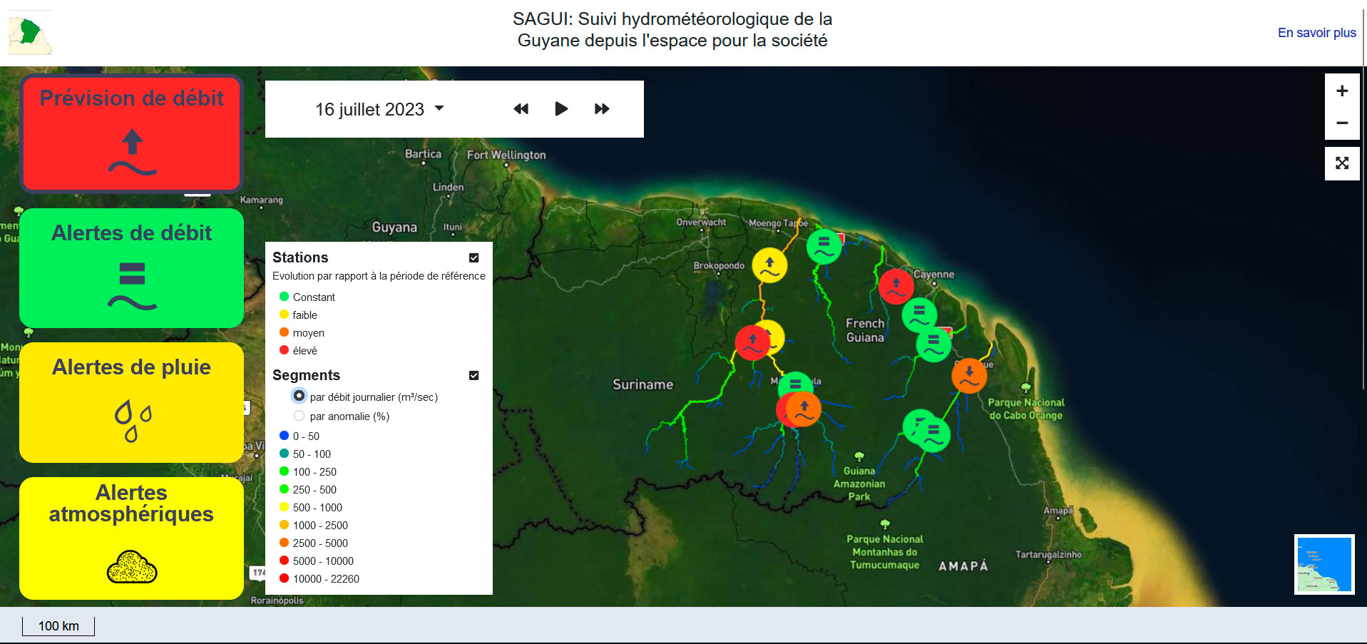
Screenshot of the home page of the graphics platform, with the various selectable tabs on the left, the map in the centre and the legends to the right of the tabs. The color of the watercourses depends on the daily flow rate displayed in the time box (top left). © Hydromatters
- In the 'Flow forecast' tab (“Prévision de débit »), the POIs are colored according to the deviation from the ten-day average between, as desired, 1980-1990, 1990-2000, 2000-2010 and 2010-2020.
- The 'Flow alerts' tab (« Alertes de débit ») shows the alert level for the POIs (flood or low water) associated with these flows. Clicking on one of the POIs takes you to the flow time series for the past year and the forecast for up to 10 days ahead.
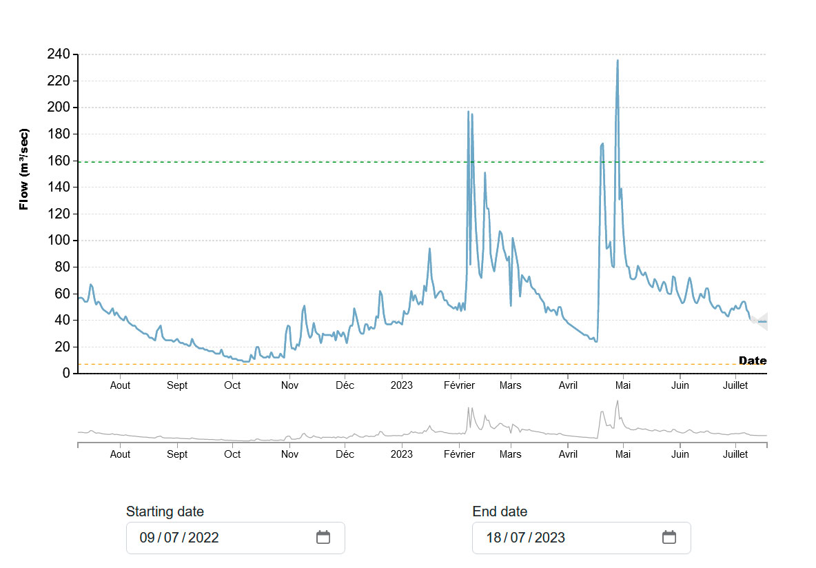
Screenshot: when the POI "Kourou" is clicked, the series of flows simulated by the model and forecast for 10 days is displayed. The display dates can be selected to display shorter periods. The "y" axis is the flow in m³/s, the green dotted line is the low flood alert threshold, the orange dotted line is the low water alert threshold. © Hydromatters
- The 'rainfall alerts' tab (« Alertes de pluie ») displays the intensity of rainfall over all the catchment areas.
- The 'atmospheric alerts' tab (« Alertes atmosphériques ») provides an air quality indicator also based on satellite data. These two tabs were developed as part of the SAGUI project, while the flow tabs are based on data generated by the OpHySE project.
For all four tabs, all the information displayed can be downloaded via an api service available here: https://sagui.hydro-matters.fr/api/v1/.
Timetable of realization
- t0 (June 2021): User workshop allowing 1) the inventory of the existing, 2) the choice of the places of interest where the information will be delivered, and 3) a draft of specifications for the indicators (which variables and at which frequency?)
- t0+6 months: Refinement of the specifications for the indicators, inventory of satellite and in situ data, necessary data collected in the database and calibration of the MGB model done.
- t0+9 months: Finalization of 1) indicator and user interface specifications, and 2) model calibration
- t0+12 months: Predictability analysis of pools and implementation on server
- t0+18 months: Implementation of the operational platform at the client's site
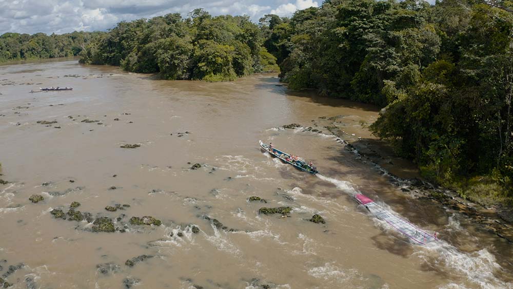
Dry season or rainy season, the flow of rivers (and therefore their navigability) varies intensely. © Jonathan CALMANT
References
| OpHySE on GEO Knowledge Hub, a long lasting digital repository created by the Group on Earth Observations: https://doi.org/10.60566/6jatt-ef167 |
Related project(s)
SCO OpHySE-MoCha, adaptation d'OpHySE au Canal du Mozambique
Project News
- 16/10/2023: Presentation of the OpHySE project and its progress at the 10th SCO France Quarterly Meeting "Water: between stress and risk".
- 19/7/2023: OpHySE delivers its platform for real-time hydrological monitoring of Guyanese rivers
- 28/02/2022: Direction Guyana with OpHySE, Advance to February 2022
- 16/09/2021: Also led by the HydroMatters team, the SAGUI project will draw in part on OpHySE data to provide real-time monitoring of environmental and climatic variables throughout French Guiana for monitoring and alerting purposes in the event of imminent risk. SAGUI (Guiana's water and air alert GIS/Sig d'Alerte pour la Guyane sur l'eaU et l'aIr) was awarded the second prize in the Space tour 2021 as part of the territorial component of the Plan de Relance Spatial, on the theme "Planning the Guianese territory using space data".