

CarbonAtlas-THA

Satellite-based Carbon Mapping for Thailand’s Forest Ecosystems
Overview
Thailand’s forests serve as crucial carbon sinks, helping mitigate climate change. However, deforestation and degradation reduce their ability to sequester carbon effectively. The CarbonAtlas-THA project enhances Thailand’s Monitoring, Reporting, and Verification (MRV) systems by integrating advanced geospatial technologies— including satellite remote sensing, LiDAR, and AI/ML—to improve the accuracy of forest carbon stock assessments.
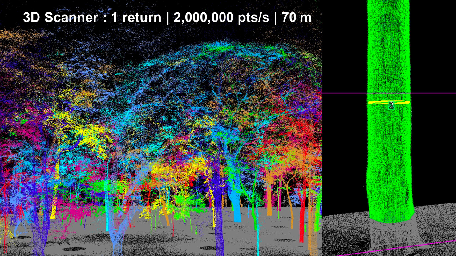
👉 The project focuses on five key carbon pools: above-ground biomass, below-ground biomass, deadwood, litter, and soil organic carbon. High-resolution satellite imagery, terrestrial laser scanning, and UAV-based data collection will enable precise tracking of forest carbon stock changes. AI-driven models will further refine biomass estimates, ensuring scalability and reliability.
👉 At the initiative's core is the Carbon Atlas, a centralized carbon stock data collection, analysis, and reporting platform. This tool aligns with Thailand’s 20-Year National Strategy (2018–2037) and commitments under the Paris Agreement, enhancing national climate policies and sustainable forest management.
By uniquely integrating geospatial innovations with policy-driven climate action, this project establishes a robust framework to ensure Thailand’s forests remain effective carbon sinks in the fight against climate change.
Application site(s)
Thailand (national coverage)
Data
Satellite
- ALOS-2 HH, HV (SAR)
- Sentinel-1 (VV, VH, RVI)
- Sentinel-2 (Optical indices, biophysical parameters)
- Landsat-8 (NDVI, LST, VCF)
- GEDI Forest Height
- SRTM (Topography)
- Dynamic World land cover
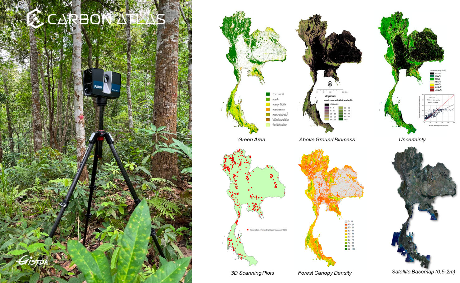
Results - Final product(s)
|
CarbonAtlas, the Carbon Digital MRV Platform iscover an Innovative Approach to Carbon Measurement and Reporting Access the platform at: |
|

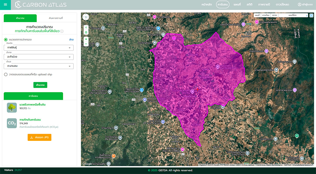
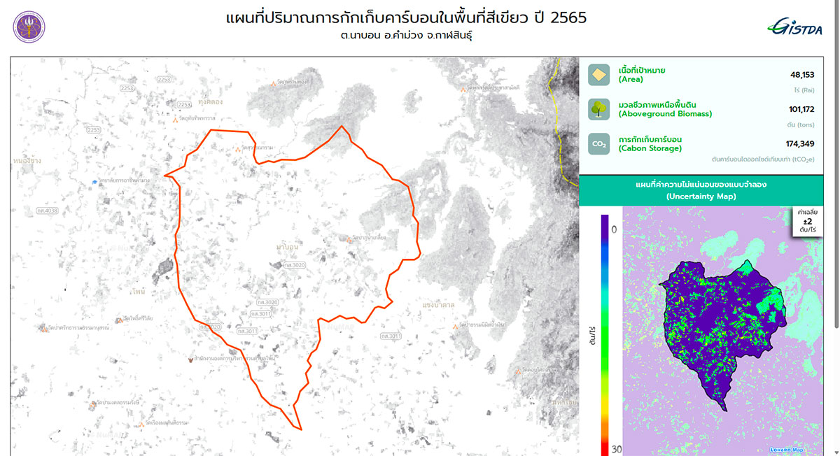
The Carbon Digital Measurement, Reporting, and Verification (MRV) Platform provides a cutting-edge solution that leverages remote sensing technology and artificial intelligence to enhance carbon-related initiatives. Our objective is to facilitate the advancement of your green and carbon economy through precise and efficient solutions.
The platform currently provides above-ground biomass (AGB) and carbon stock data for Thailand (2022) across various scales, ranging from individual parcels to administrative regions, including sub-districts, districts, and provinces. Users also have the option to download maps in .jpg format. An updated dataset for AGB and carbon stocks for 2024 will be available by the end of October 2025, with plans to conduct updates every two years (next scheduled for 2026 and 2028). Following 2028, updates will transition to an annual basis. While the platform is presently available in Thai, plans are underway to offer English language support by 2026.
👉 Detailed methodology and tutorial available below in the Resources section.
|
Key Benefits:
|
Key Focus Areas:
|
|
Key Features:
|
Applications:
|
Operational Framework:
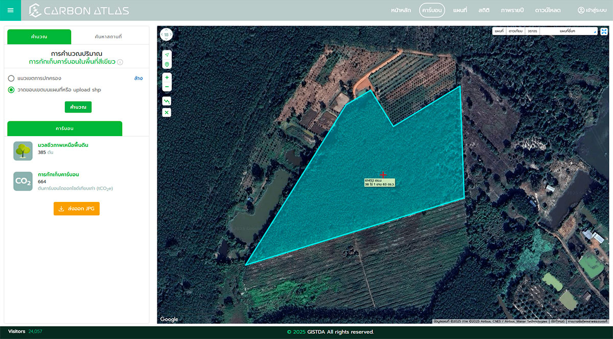
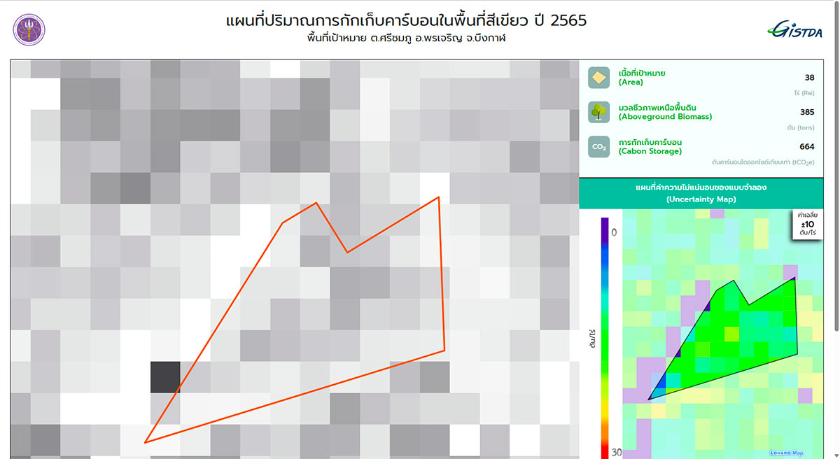
- Define Land Parcel: Users can upload field boundaries or utilize the interactive map to confirm geolocation criteria.
- Run Models: The platform processes data and generates carbon estimates using TGO-approved modelling techniques.
- Review MRV Report: Detailed reports are provided, including carbon stock assessments, emissions/removals, and potential credit calculations in accordance with T-VER standards.
- Download or Connect via API: Users can retrieve data in report format or integrate it into their systems through API connections for automated workflows.
|
|
|
|
|
|
All images © GISTDA
Related project(s)
-
🇮🇹 SCO CACAO :a platform to facilitate carbon credit trading, from analyzing forest CO2 sequestration to managing transactions in Italy.
-
🇫🇷 SCO CARBOSPACE : automated solution for monitoring carbon sequestration and biomass via satellite, to improve the reliability of carbon credits in Australia.
-
🇫🇷 TropiSCO : platform for near real-time monitoring of tropical deforestation, covering Thailand.
Project news
🎥 27/10/2025: Presentation of the CarbonAtlas-THA project and its progress at the 2nd ClimateSCOpe “Eyes on the forests”