

SCOFrance
A Cartovege drone mission25 minutes flight time per battery
3 ha covered
700 photos
Useful linksCartovege project
Cartovege2 project
Polar Institute's SUBANTECO project 136
Key wordsDrone, training data, validation data, orthomosaic, observed map
Cartovege exploits the complementary nature of drone and satellite data
At the heart of the SCO's work to automate monitoring systems and prediction models, spatial data generally offers its added value as a complement to other data sources. When they exist... If they don't, the ideal solution is to retrieve the information in the field.
Cartovege and satellite data
Awarded the SCO label in March 2021, the Cartovege project uses satellite data to develop a decision-making tool for conserving flora and preserving habitats in the Crozet and Kerguelen archipelagos, by combining vegetation mapping and predictive modelling of the changes that could affect it.
In order to be effective on a large scale and reproducible at low cost, the modelling is carried out using "machine learning" based on satellite remote sensing data to automate the mapping of the different types of vegetation. This data is combined with field surveys to train the model and check the accuracy of the vegetation classification produced. However, the traditional method of retrieving this data in situ (floristic surveys) has its limits, especially in an environment where the terrain is very restrictive.
Using drones
"Using a drone to monitor vegetation is a scientific and technological gamble that has paid off in the French Southern Territories, where the wind has a major influence on the way sampling campaigns are conducted," says Diane Espel, a postdoctoral researcher in remote sensing and ecological modelling working on the Cartovege project. A drone remote pilot for the CNRS since 2018, the young woman proposed using this tool "to generate input data to train and validate our automatic mapping model of the diversity of natural terrestrial habitats in the French Southern Territories".
"When developing a model, training and validation data are the lifeblood.
Looking for a balance between weight, image quality and price, Diane Espel set her sights on a small quad-rotor drone weighing 600 grams with a 30 cm wingspan, equipped with a 1" CMOS optical sensor capable of capturing 20 megapixel images, and six batteries. "The drone is a turnkey system that fits in a rucksack, which is very practical in these hilly landscapes," she says.
Effective from the very first campaign
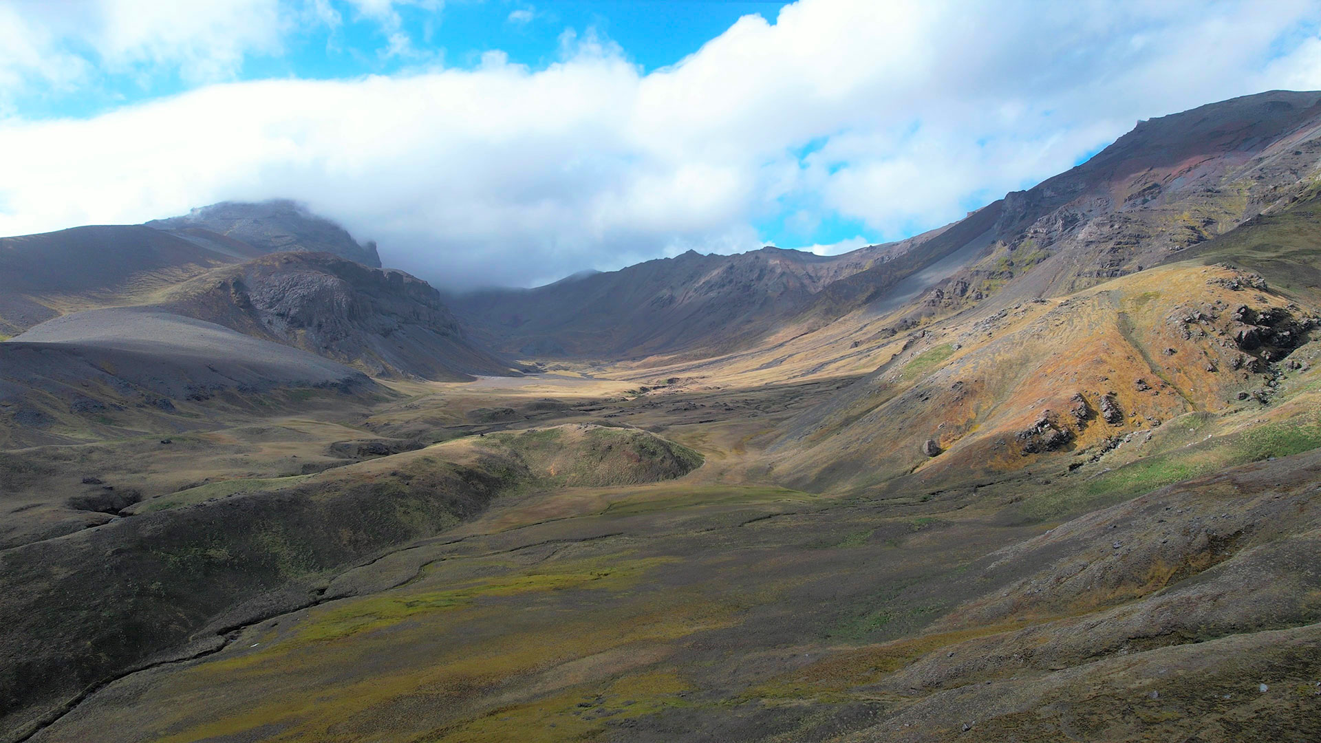
After meticulous preparation of the flight programme, based on a satellite map of the island of La Possession (Crozet archipelago), Diane was able to carry out the first drone campaign supported by the French Polar Institute (project 136-SUBANTECO), during the austral summer, from November to December 2022, "a period when the vegetation that makes up the habitats is at its peak of development". Crozet has been classified as a 'nature reserve' since 2006, so the remote pilot took care to apply for the necessary prefectoral authorisations beforehand and asked the ornithologists on site to avoid the areas along the coastline that are off-limits to overflights (nesting sites, presence of colonies).
|
|
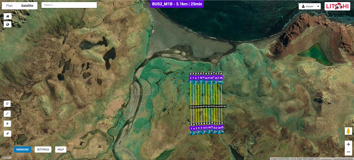
◀︎ Flight programming, based on a satellite map of the island of La Possession, using the Litchi application. Following a predefined 'zigzag' circuit, the drone will take photos of the vegetation every two seconds at constant altitude and speed, which will be recombined into a single orthomosaic. © CNRS D. Espel 2022 |
At the end of the month-long campaign, the feedback is excellent: on the five sites selected, the drone flew 21 missions and acquired almost 15,000 images. Each mission was equivalent to 25 minutes of effective flight time per battery, during which the drone covered 3 hectares, taking 700 photos.
"With its small size, the drone is perfectly suited to this type of environment where only weather conditions (cold, fog) can disrupt the remote-control signal. The model adopted by the team (a DJI AIR 2S) is very stable in winds of up to 40 km/h and does not disturb wildlife in any way, particularly Skuas (birds), which can approach it despite the precautions taken. However, it is best to stay close to a hut that has a generator or a good solar battery to recharge the batteries. In terms of use, the images obtained meet our expectations perfectly", summarizes the scientist.
Using drone data
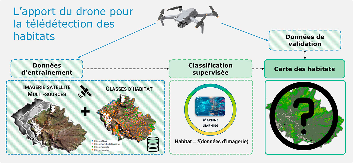
Methodologically speaking, the data generated by the drone, associated with different types of habitats, is injected into the model to train its supervised classification and then to validate, if not correct, its predictions. © Cartovege
After this initial campaign, Diane Espel lists all the drone's applications. Remember that the model, which is regularly mentioned in this article, is powered by satellite data.
|
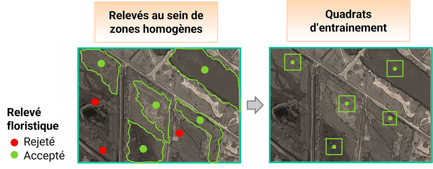
▲ Location of floristic surveys on a drone orthophoto background. © Cartovege/D. Espel |
|
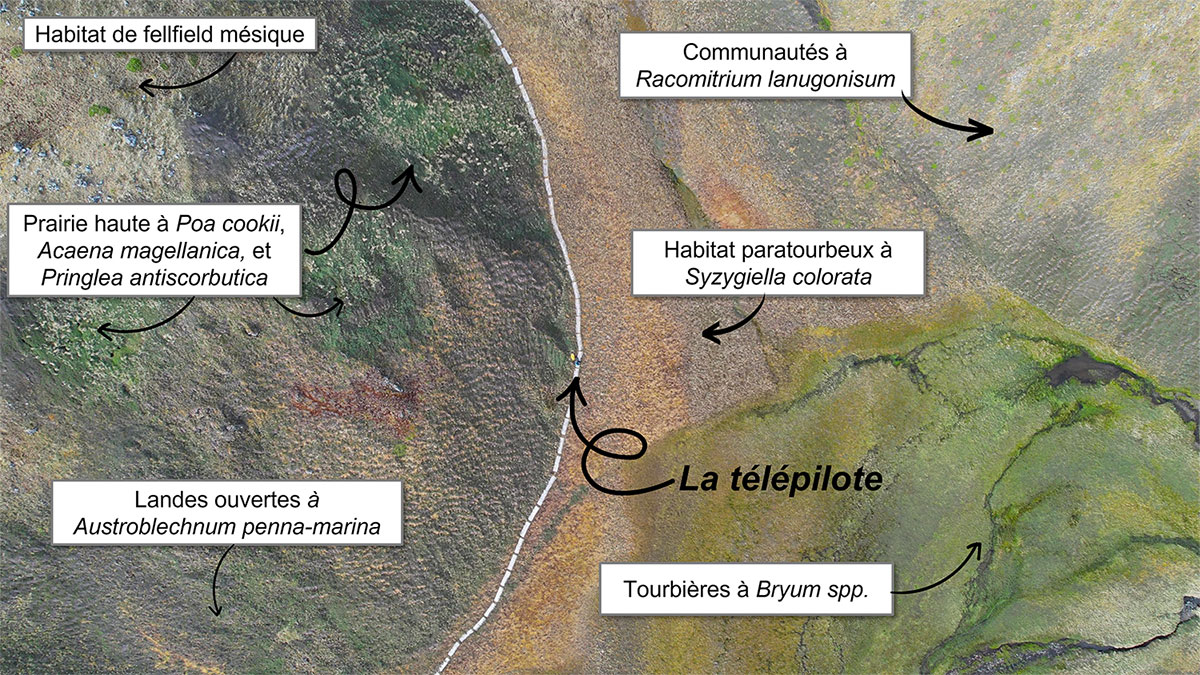
▲ Drone orthophoto, taken from a height of 60 m, showing the diversity of habitats in an aerial view of La Pérouse Bay (Possession Island). © CNRS D. Espel, Décembre 2022 |
|
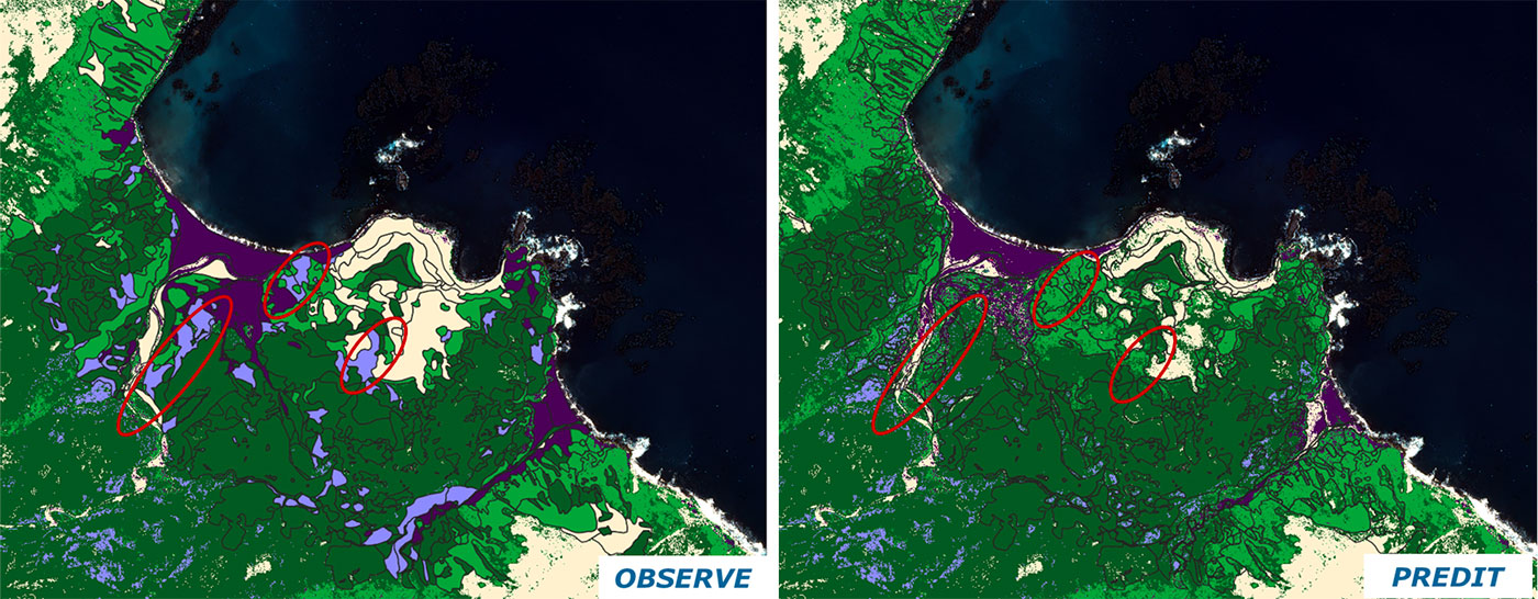
▲ Comparison of maps of habitat types observed by the drone (left) with those predicted by the model using multi-source satellite imagery (Pleiades and SRTM) (right). The maps shown here correspond to a portion of Possession Island (Crozet Archipelago), in the American Bay. © Cartovege |
The drone flies at an altitude of between 40 and 60 meters, depending on the terrain, and takes orthoimages (i.e. images taken at ground level) at regular intervals along its predefined route. |
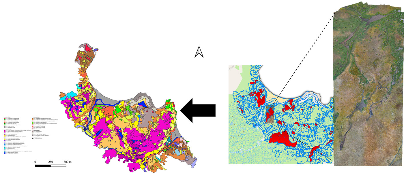
▲Use of an orthomosaic for fine photointerpretation of habitats. The red polygons on the map on the right represent the areas to be flown over as a priority, due to the model's prediction errors in these areas. © TAAF Direction de l'Environnement S.Traclet 2022 / CNRS D. Espel 2022 / Cartovege |
Assembled into a single view called an orthomosaic, Diane Espel uses these to visually interpret the habitat types and produce a map of the habitats observed. This map can be used to correct any errors in habitat prediction by the model.
These geo-referenced orthomosaics can also provide evidence of the vegetation at different scales and can therefore be used for before-and-after studies, for example to check the effectiveness or impact of a management measure, such as an operation to eradicate introduced mammals (rodents), which have an impact on the vegetation through the consumption of seeds.
- Production of videos, particularly useful for communicating about the project or exploring the surrounding area.
With so many assets, the drone has won over the whole team, who intend to make the most of it to roll out Cartovege2, designed to transpose (from November 2023) the model developed on Crozet to two other islands in the French Southern Territories (Saint-Paul and Amsterdam), with their subtropical climate. "Thanks to this first campaign, we have been able to put in place a protocol for using the drone that is not too restrictive for users and that can be used all year round," sums up Diane Espel.
If you're interested in the drone adventure, you too can become a professional remote pilot. To do so, you will need to obtain at least theoretical certification and undergo practical training in an instructor center recognized by the French Civil Aviation Authority.
Bonus photo
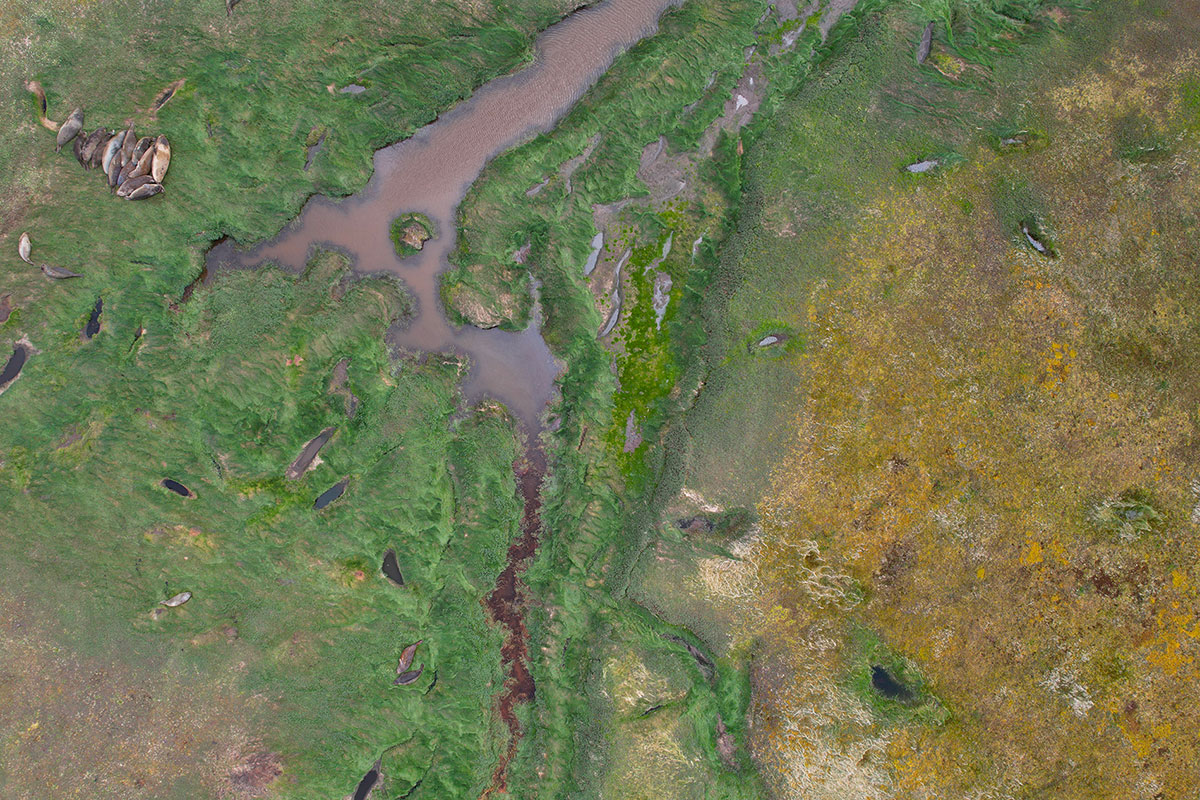
Drones are an excellent way of generating field data without disturbing vertebrate fauna in particular. This image shows elephant seals basking in the sun on the Poa annua lawn in the American Bay, not bothered at all by the drone flying overhead! On the right-hand side of the image, you can see the temporary pools and paratourbous habitats. © CNRS D. Espel, Décembre 2022