

CARTOVEGE

CARTOgraphy by remote sensing of plant formations and habitats, and production of inferences of the effects of global changes on the occurrence of plant species for the purposes of management and preservation of natural areas
Part 1 completed
Now operational on the Crozet & Kerguelen archipelagos, the Cartovege tool provides a cartographic model of habitats specific to the French Southern Territories, particularly useful for some of their islands that are inaccessible to humans. This replicable solution is already being transposed to the neighboring islands of St Paul and Amsterdam as part of a second phase, Cartovege2.
OVERVIEW
Temperatures are increasing at an unprecedented rate in many parts of the world, particularly in alpine and polar regions. These changes are inducing a redistribution of species and modifications of natural and semi-natural habitats, with impacts on communities and ecosystem services. In addition, the characteristics of many habitats are being altered by anthropogenic activities and invasive alien plant and animal species. By reshaping species distribution and habitat composition and functionality, these changes affect biodiversity health and ecosystem functioning. At the level of plant communities, the processes of homogenization of biocenoses and loss of native species that result from these changes are also amplified by the incursion of exotic species. Faced with these challenges, it is urgent to have maps of biodiversity at different scales, associated with a modeling of the various factors governing the distribution of this diversity in time and space. The acquisition of this knowledge is all the more important for the conservation and management of protected areas in France, such as nature reserves.
Located in the southern Indian Ocean, between Madagascar and Antarctica, the Crozet archipelago, part of the French Southern Territories National Nature Reserve (RNN TAF), is of particular interest because of its unique landscapes (Figure 1) and of the presence of numerous endemic and heritage-rich species it harbors. These characteristics led to the islands being designated a UNESCO World Heritage Site in 2019. Since the mid-1950s, the French Southern Territories have undergone significant climatic changes, marked by an increase in annual temperature, a reduction in the number of winter frost days, and increasingly frequent water deficits (rainfall) during summer periods. These changes, coupled with human disturbance, have facilitated the establishment and expansion of non-native plants, exacerbating the threats to native biodiversity.
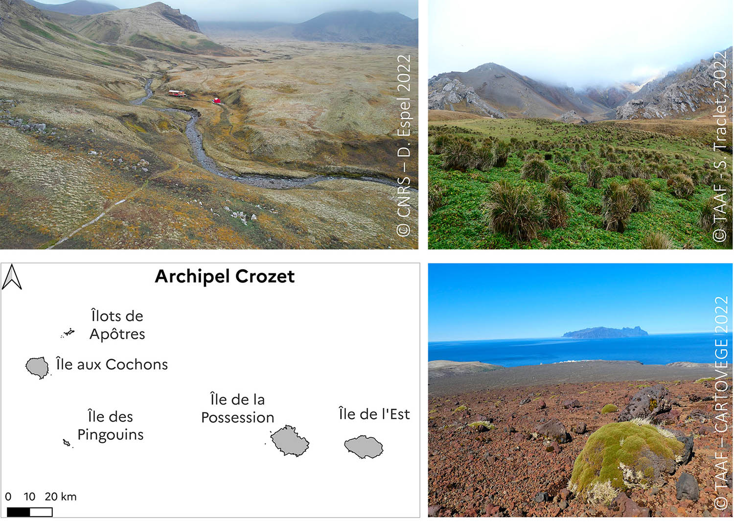
Figure 1: Crozet archipelago and its 5 islands: typical habitats on the island of La Possession
In this context, the conservation of flora and the preservation of habitats constitute major challenges for the manager of the RNN TAF, who needs to have relevant decision-support tools at his disposal. Knowledge of the spatial distribution of species, coupled with precise information on the environments they prefer to occupy (pedology, topography, companion species, etc.) is thus essential for proposing operational solutions and ensuring their long-term monitoring. Until now, such synoptic information on threatened plant species and habitats have been patchy at the scale of the RNN territories.
The project team therefore set about (1) drawing up an inventory of habitat diversity, distribution and fragmentation, and (2) providing the first complete map of the archipelago's vegetation, using a new open-source cartographic modeling tool.
The remote sensing tool we have proposed is based on extensive field monitoring of the flora of the Crozet Islands, a range of satellite and aerial imagery, a suitable vegetation typology and image analysis and predictive modeling methodologies.
This approach, which can be transferred to other territories, is new and will make it possible to prioritize areas more reliably when setting up management plans. The project also represents a unique opportunity to increase our understanding of the interactive effects of climate change and non-native species on biodiversity dynamics
Application site(s)
French Southern and Antarctic Lands: Crozet Archipelago
DATA AND TOOLS
Satellite
- High spatial resolution (multispectral) imaging: Pleiades, Spot 6/7 (Mono/Tri-Stereo): East Island and Possession Island (February 2022)
- Digital elevation model and slope raster: SRTM scene
- Infrastructures: Dinamis (Data Terra) and NASA
Drone
- Aerial images (RGB) taken with DJI AIR 2S
Field data
- Historical data (2010-2022) from the Habitats-Flora-Invertebrates database co-managed by the RNN TAF and the SUBANTECO IPEV/136 project: this database compiles geo-referenced data on the flora and invertebrates of the Crozet Islands and associated environmental conditions (nature of substrate, slope, altitude, soil moisture, etc.) in the French Southern Territories (Crozet, Kerguelen and Amsterdam).
- Crozet wintering data 2022-2023: photo-interpreted map of habitats around encampment areas for the creation of learning segments
- Data from Crozet 2022 summer campaign(s): additional floristic data to (i) refine and validate the ecological typology; (ii) train and (iii) validate the habitat classification model.
Literature data
- Ecological knowledge: biological invasions, autoecology and synecology of native and non-native species, phytosociology.
- Knowledge of spatial modeling and remote sensing
- Knowledge of statistical processing: ascending hierarchical classification, clustering, etc.
- Literature review of sub-Antarctic island habitats
Tools
- Statistical tools
- Pixel/object-oriented classification models: machine learning (Random Forest, Support Vector Machine, etc.)
- Automatic classification of vegetation surveys: automated criteria and classification methods using multivariate analysis and clustering
- Programming language(s): R / Bash
- Database manager language : PostGre SQL
- Cartography/photogrammetry visualization tools
- Geographic information system software: QGIS
- Drone image stitching software (photogrammetry) : Agisoft Metashape
- CarHab map hosting tool: https://inpn.mnhn.fr/viewer-carto/CarHab/
FINAL PRODUCTS
-
Data banking of the georeferenced distribution of the flora of Crozet Island, satellite images used for habitat mapping.
-
Production of the 1sthabitat typology for the Crozet archipelago (ecological typology)
-
Creation of a remotely detectable typology
-
Production of 34 orthomosaics (< 1 cm resolution) of the island of La Possession (representing 4% of the island).
-
Production of an automatic processing chain for satellite imagery and field data for remote sensing of habitats (remote sensing pipeline).
-
Production of remote sensing tool tutorials (Rmarkdown files)
-
Model-based mapping of habitats and vegetation in RNN TAF, based on available material (naturalist data and explanatory variables).
-
Comparative mapping of habitat modelling on the islands of the Crozet archipelago for 3 typological levels: East Island in integral reserve, vs. Possession Island, in order to assess the effect of climate change in the absence of anthropogenic disturbance.
-
Integration of habitat typology information into the HABREF database, and of the maps produced into the CarHab web platform.
-
Production of a habitat guide for the Crozet archipelago: identification key and summary sheets.
-
Field monitoring tools: drone habitat monitoring protocol, simplified habitat field monitoring protocol
MAIN RESULTS
Guide about the terrestrial habitats
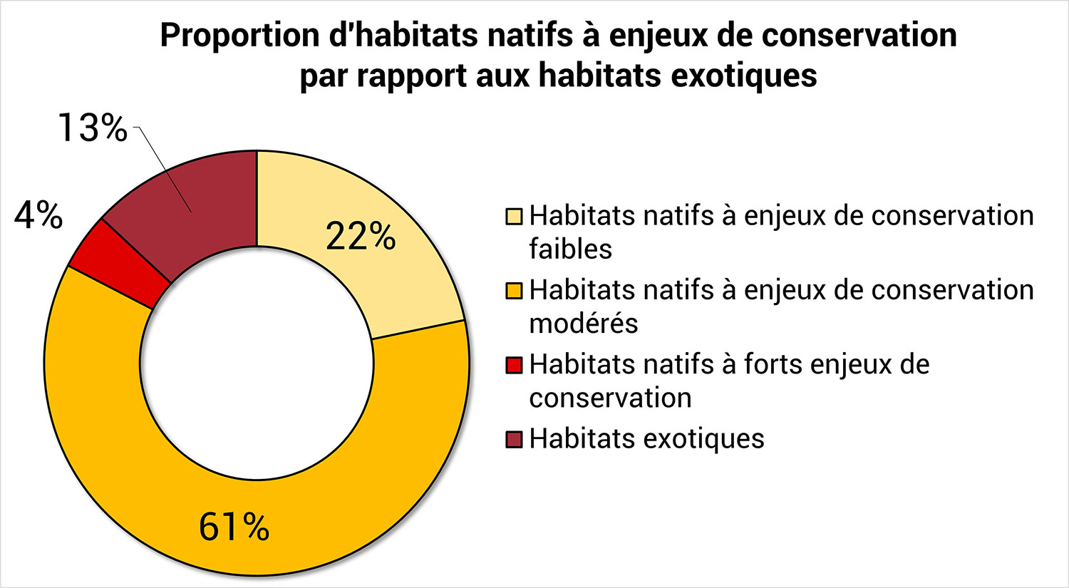
Inspired by phytosociological classification methods (hierarchical classification) and based on more than 3,000 field data, after defining environmental, physiognomic and floristic criteria, we drew up the first vegetation classification for the island of La Possession. A total of 46 vegetated and non-vegetated habitat types, both native and exotic, were identified.
|
Among them:
|
Figure 2. Proportion of habitats with conservation and management issues |
The expertise acquired on the habitats of the island of Possession and the detailed knowledge of their associated environmental conditions have enabled us to describe each type of habitat precisely, and to use this knowledge to produce a guide about the terrestrial habitats of the Crozet archipelago.
Published on 5 December 2024 by Quæ, this guide presents one of the most complete typological classifications of natural terrestrial habitats in the terrestrial ecosystems of the French overseas territories. Thanks to a detailed methodology, a determination key and richly illustrated descriptive sheets, the book will enable interoperability between scientific programmes and consistency in the data collected.
Reference: Espel D., Agnola P., Traclet S., Dupont V., Renault D., 2024. Natural terrestrial habitats of the French Southern Territories. Île de la Possession, Crozet archipelago. Versailles, éditions Quæ, 202 p. (practical guide series)
Cartographic modelling
Using the ecological classification (or typology) established, we then developed a cartographic modeling tool producing habitat information at different spatio-temporal scales. The tool was developed entirely with R language, through a pipeline for processing field and imagery data, in order to standardize and automate the prediction of habitat maps, thereby minimizing human error and ensuring a certain degree of transposability.
|
Semi-automatic mapping, based on satellite remote sensing data coupled with field surveys and machine learning algorithms, is the most effective way of mapping vegetation on a large scale, and applying homogeneous, reproducible methodologies that enable cost-controlled updates that are comparable both temporally and spatially. In particular, methodologies based on supervised classification algorithms deliver highly reliable results. |
▲ Figure 3. French Southern Territories terrestrial habitat mapping tool |
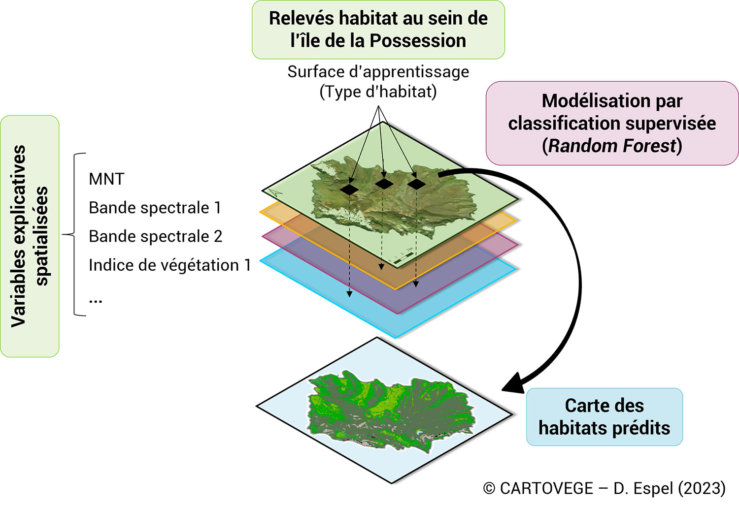
Thanks to field and drone monitoring, associated with very high-resolution (50 cm) Pleiades satellite imagery and a digital terrain model, we combined remote sensing vegetation mapping approaches with over 9,000 habitat learning data, to predict habitat maps at 3 typological levels (from coarse to fine) for Possession Island and East Island (Figure 3).
The supervised method was used to develop a model for each typological level, using training data specific to each habitat type and 7 explanatory variables: 1 topographical variable, GREEN band, PIR band, 2 vegetation indices, 1 moisture index and 1 bare soil index.
The ecological typology and the pipeline were then used to create a so-called "remotely detectable" typology, and to derive 3 high-resolution maps for the islands of La Possession and Ile de l'Est, in the Crozet archipelago (Figure 4) :
- 1 level 1 map representing the 4 natural environments
- 1 level 2 map representing 12 habitat types
- 1 level 3 map showing 31 types of plant formations and non-vegetated habitats
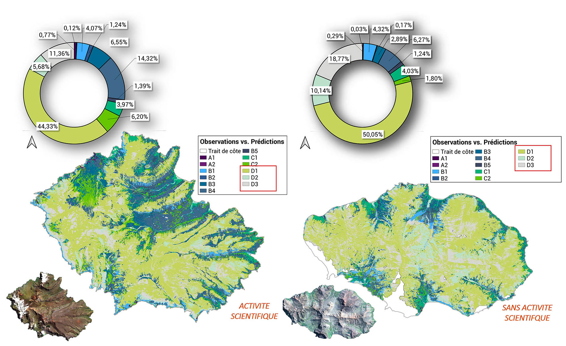
Figure 4. Predictive maps of Crozet archipelago habitats obtained for the 2ème typological level: Possession Island (left) vs. East Island (right).
On the basis of 4 global metrics, the performances of the 3 models applied on the island of La Possession were considered as :
- Good for the 1st and 2nd typological levels, with an overall error rate limited to 43% (Overall accuracy: 72% and 58% respectively).
- Acceptable for the 3rd level (Overall accuracy: 50%)
The third level is encouraging for 32% of habitats, but there is still room for improvement, particularly through the acquisition of new training data for the least represented classes (i.e. < 110 records).
By analyzing local errors in certain areas of the island and 8 specific metrics (i.e. calculated class by class), we were able to identify sources of error that were unavoidable or could be easily corrected with a view to updating/improving the maps obtained:
- Imagery limitations (DTM resolution too coarse, presence of clouds, shadows)
- Interclass spectral similarities are still too high
- Highly localized habitats (coastal habitats) with less learning data and many variations
Although we have no validation data for the East Island, comparison of the maps obtained with Possession Island (Figure 4) and their respective Pleiades satellite images has also revealed certain trends:
- The substrate of East Island is much more mineral (classes D1 to D3) than the one of Possession island, with vegetation concentrated in the few apparent valleys.
- There also seems to be a better balance between wetland habitats (class B) and mesic vegetated habitats (class C).
- Finally, it's interesting to note that exotic habitats are very localized and restricted (only to the small known penguin colonies) on the East Island, where humans are not allowed.
Today functional and transposable to other territories and/or applications, thanks to the independence of the scripts that make it up, the mapping tool can be easily adjusted and improved over time to adapt to the changing needs of a project or organization.
It will soon be transposed and improved in other TAAF territories: (1) in the short term on the Saint-Paul and Amsterdam islands (SCO-CartoVege²), in the medium term on certain sectors of the Kerguelen archipelago and on the Éparses Islands. The next step will be to integrate this cartographic tool with managers as part of an adaptive monitoring approach for the territory.
References
| CARTOVEGE on GEO Knowledge Hub, a long lasting digital repository created by the Group on Earth Observations: https://doi.org/10.60566/0b4s1-x7g09 |
- Espel D., Agnola P., Traclet S., Dupont V., Renault D., 2024. Natural terrestrial habitats of the French Southern Territories. Île de la Possession, Crozet archipelago. Versailles, éditions Quæ, 202 p. (practical guide series)
RELATED PROJECTS
- CARTOVEGE2, extending CARTOVEGE to the islands of Saint-Paul and Amsterdam
- Project of the French Polar Institute Paul-Emile Victor IPEV 136 'SUBANTECO'(Subantarctic biodiversity, effects of climate change and biological invasions on the terrestrial biota', 2018-2021, then 2022-2025)
- H2020 BiodivERsa call 2019-2020 Biodiversity and Climate Change 'ASICS' project (ASsessing and mitigating the effects of climate change and biological Invasions on the spatial redistribution of biodiversity in Cold environmentS)
- SoilTemp: a global database of soil microclimate and soil surface data
- InEE-CNRS Antarctic and Southern Territories Workshop Zone: long-term monitoring of Antarctic and sub-Antarctic biodiversity and ecosystems.
- SCO Space4Nature, satellites and AI to map habitats in the UK
Project news
-
14/01/2025: Cartovege: the Habitats Guide has been published
-
05/03/2024: Transition for Cartovege
-
25/07/2023: Cartovege exploits the complementary nature of drone and satellite data
-
03/10/2022: Cartovege stimulates science and EO by organising a scientific seminar on data analysis and by participating in the international symposium Intecol 2022
-
30/09/2022: Presentation of the Cartovege project and its progress at the 6th Quarterly Meeting of the SCO France on the theme Monitoring the evolution of natural areas by remote sensing
-
14/09/2021 : Satellites, amazing allies of biodiversity: presentation of the Cartovege project at the IUCN World Conservation Congress 2021
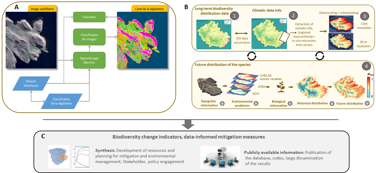 Figure 3