

SCOFrance
Useful linksChove-Chuva interface
🎥 Presentation of the project and details of the results
Key wordsTerritorial dynamics, data interoperability, citizen participation
Chove-Chuva shows how territorial dynamics are changing
On Friday 24 November 2023, a remarkably close-knit team came together to present Chove-Chuva, the first operational demonstrator for monitoring territorial dynamics. Developed in the state of Mato-Grosso in the Brazilian Amazon, this totally open source web mapping interface provides simple indicators of changes in climate variables and land use. There is also a module inviting people to take part in the project in order to identify how local people perceive climate change, and to pinpoint rational land-use practices such as reforestation and crop-livestock-forest integration, which are often difficult to identify because they are carried out on small plots of land.
Functional balance sheet
- An operational geographical platform
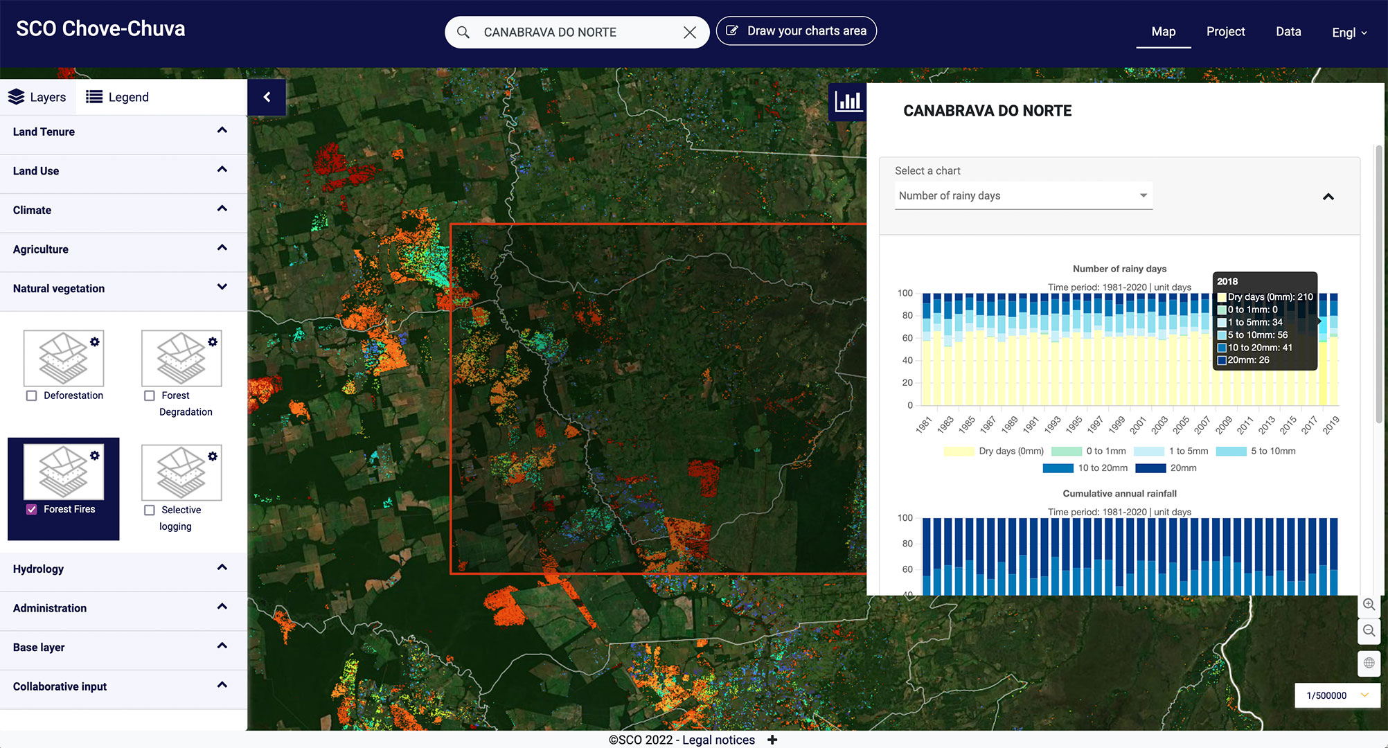
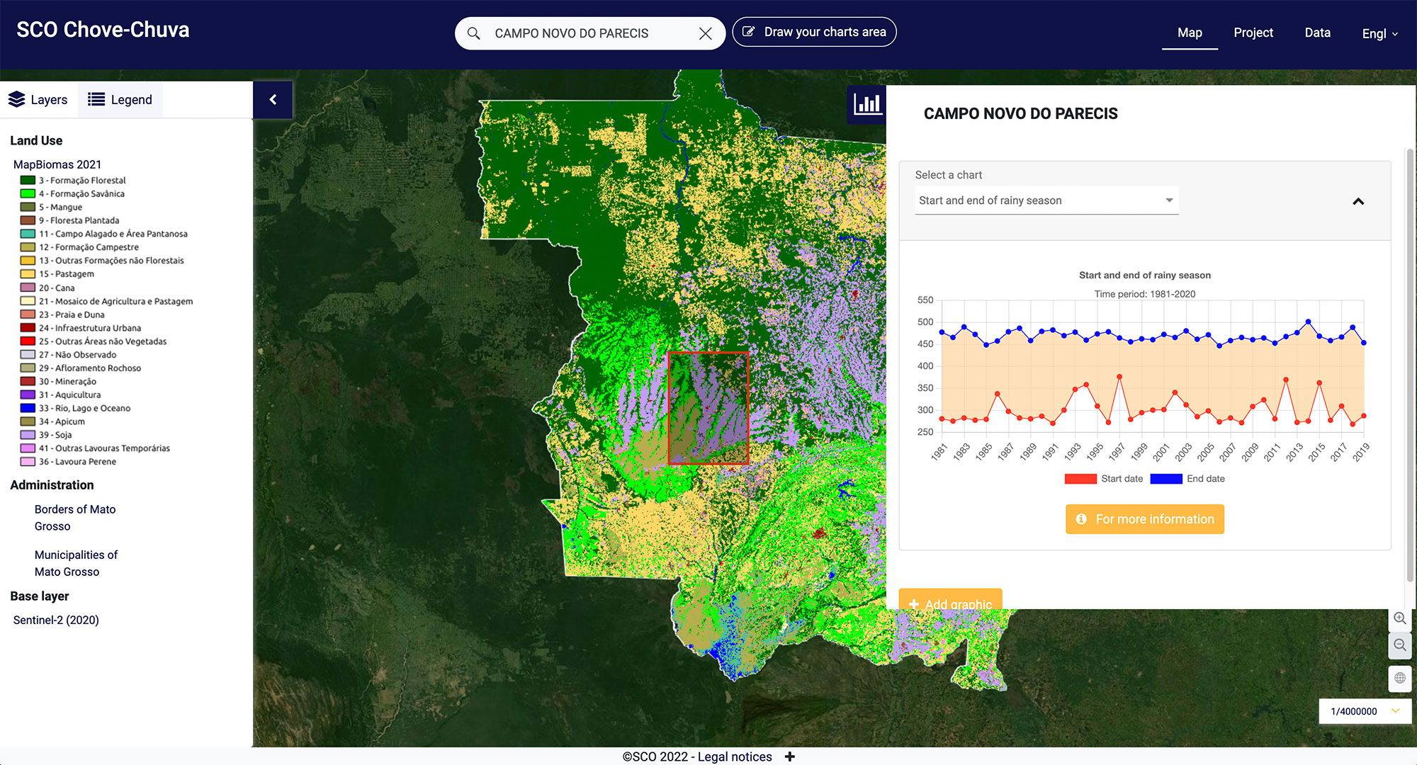
With Chove-Chuva, users can interact with a set of spatialised data (raster, shapefile) at the spatial scale of Mato Grosso. A dynamic selection enables users to refocus their interest on a smaller study area or on an entire municipality for which local statistics can be consulted (synthesis of spatialized products). For example, data on forest fires (visual) coupled with rainfall statistics for the municipality of Canabrava do Norte (graphic). © Alkante
👉 See detailed results on the project page
- Excellent feedback from Brazilian users, some of whom are proposing continuity with the addition of new spatialised datasets, particularly hydrological ones
- A large-scale demonstration: presented to the GIP RECIA (Loire Valley Centre) and the French Ministry for Ecological Transition, Chove-Chuva demonstrated its full potential in terms of data interoperability and the integration of satellite data into the Prodige geographic data infrastructure.
The effectiveness of combining research and the private sector
The Chove-Chuva project consortium is the cornerstone of the SCO spirit, bringing together a wide range of players to produce a demonstrator as quickly as possible that truly meets the characteristics and needs of the region:
- French players: Alkante, LETG and TETIS joint research units, CIRAD, GeoDev, CNRS and CNES
- Brazilian players: UNEMAT, UERJ, EMBRAPA, CAT, ICV, SEMA-MT, FEC
What about tomorrow?
In addition to this fruitful partnership, the project leaders, UMR6554-LETG, under the supervision of the CNRS and the University of Rennes 2, and the Breton company Alkante, an expert in digital solutions, have discovered an unsuspected complicity at the outset. Today, they are looking forward to working together to achieve further milestones.
In particular, Alkante undertakes to continue with Chove-Chuva in order to maintain the hosting of the tool on its servers, monitor current services and continue to develop the tool by adding new functionalities and/or ways of doing things. In another field, that of the fine spatialization of the heat island, the Altelys project, labelled SCO in 2023 and led by the same team, will benefit from certain functionalities of Chove-Chuva.