

CHOVE-CHUVA

CHOVE-CHUVA: a tool for the dissemination of territorial dashboards in Mato Grosso (Brazil)
Project completed
The Chove-Chuva project has led to the development of a data infrastructure for monitoring territorial dynamics in Mato Grosso, based on past and current research established through long-term cooperation between the CNRS LETG Rennes laboratory, the Alkante company and Brazilian partners from a wide range of backgrounds (NGOs, institutions, the agricultural world, etc.). The aim of the project was to set up an open-access web platform (Chove-Chuva) enabling users to consult the spatial data produced and retrieved from the partners before and during the project. A function also allows users to deepen their knowledge through dynamic graphs and statistics on an area of their choice (drawing area, municipalities or protected areas). The final key point of this platform is the introduction of a citizen participation tool, in which users participate in the creation of data, in order to fill in gaps in practices that are often difficult to identify, such as reforestation or the integration of farming, livestock and forestry.
Certified in 2025, the SCO Pantanal project is a continuation of Chove-Chuva, developing a platform that integrates relevant data for monitoring wetlands in the Pantanal (Brazil).
OVERVIEW
The Brazilian Amazon, and in particular the State of Mato Grosso, has long been the scene of intense socio-environmental transformations, at the heart of the challenges of global change. These transformations are mainly explained by a very dynamic agricultural sector that, beyond its expansion strategy, is evolving to intensify and diversify its practices. This evolution is taking place in Brazil in the context of a sectoral plan for climate change mitigation and adaptation (Plan ABC; Agricultura de Baixa Emissão de Carbono) whose objective is to encourage the adoption of sustainable management practices: restoration of degraded pastures and reforestation of riparian areas, promotion of reasoned agricultural practices such as crop-livestock integration or direct seeding...
However, tools that allow citizens and community associations to have synthetic access to the evolution of conditions in their territory are sorely lacking. However, there is a great diversity of spatial information on the subject that should be disseminated to as many people as possible in order to support and facilitate the adaptation processes of communities to these changes.
The objective of the CHOVE-CHUVA project was to develop a tool for monitoring territorial dynamics in Mato Grosso. This demonstrator will be based on two major components: 1) the dissemination of spatial information on the evolution of climatic variables and the dynamics of land use (forests, agriculture, water resources) and use (agricultural practices), and 2) the location of certain types of land use advocated under the ABC plan such as reforestation or plots cultivated in integrated systems.
To meet this objective, it was necessary to pool scientific knowledge that had been built up over several years thanks to the partnership between UMR6554-LETG and Brazilian partners. In this context, a wide range of satellite data (Landsat, Modis, Chirps, Sentinel-2) was used to establish spatial indicators on various themes:
- Land use and land cover
- Climate
- Agriculture
- Natural vegetation
- Hydrology
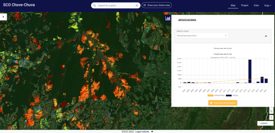
A better understanding of forest fires and the associated statistics. © Alkante
Application site(s)
Mato Grosso, Brazil
DATA
Satellite
- Sentinel-2
- Landsat
- MODIS
Others
- Products derived from satellite data (land use maps, precipitation estimates, etc.)
- Multi-thematic vector data (cadastre and official boundaries, agriculture, hydrology, natural vegetation, administration)
- Data from meteorological stations installed in Mato Grosso
- Citizen data collected
RESULTS - FINAL PRODUCTS
The tool has two purposes:
- Dissemination of spatial information
The primary objective of the tool is to make available to the greatest number of spatio-temporal indicators testifying to the territorial dynamics observed in Mato Grosso in connection with adaptation and mitigation strategies implemented by societies. Thus, we propose to mobilize information allowing, for a zone predefined by a user, to produce a "dashboard" of the territorial situation from synthetic indicators on 5 major themes:
- Climate: trends in rainfall (amounts and seasonality), rainy seasons (start, end and duration) and climatic extremes
- Forests: changes in forest cover (deforestation and degradation) and forest fires
- Water: evolution of pressures on water resources (creation of water reservoirs and degradation of riverbanks)
- Agriculture: evolution of agricultural surfaces (surface areas and practices)
- Land use: changes in land use
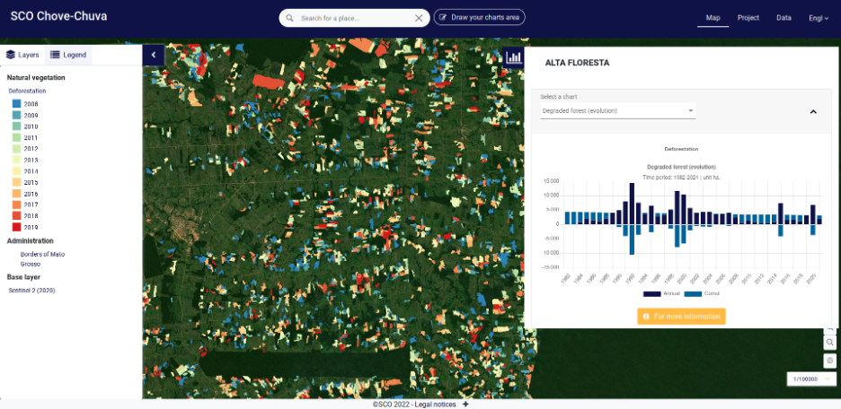
Visualize deforestation and its evolution over time. © Alkante
- Citizen data collection
The second objective of the tool is to take advantage of user visits to collect citizen data that can be used for future research. Thus, the data collection consists of the possibility given to users to locate on a satellite map types of land use advocated in the framework of the ABC plan (e.g. plots in integrated crop-livestock systems, reforestation areas).
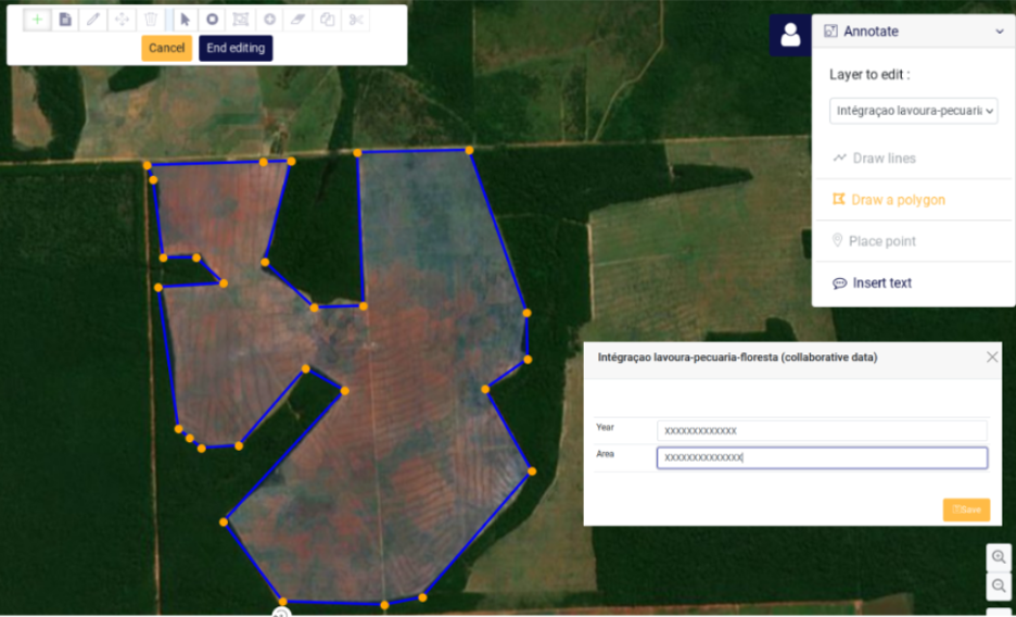
Chove-Chuva contributes to the knowledge of local areas by helping to build up data holdings through the collaborative input of information. © Alkante
References
| Chose-Chuva on GEO Knowledge Hub, a long lasting digital repository created by the Group on Earth Observations: https://doi.org/10.60566/pgm3x-b5m05 |
- Arvor, D., Denize, J., Rouxel, L. et al. The CHOVE-CHUVA Earth observation platform to monitor socio-environmental dynamics in Mato Grosso, Brazil. Sci Rep 16, 6497 (2026). https://doi.org/10.1038/s41598-026-36640-w
RELATED PROJECTS
- SCO PANTANAL, continuation of Chove-Chuva to integrate relevant data for monitoring wetlands in the Pantanal (Brazil).
- SCOLTEL: a CNRS (International Emerging Action) collaborative project between UMR LETG and UNEMAT (State University of Mato Grosso).
- CASTAFIOR: a project funded by CNES (TOSCA) on monitoring the dynamics of anthropization of forest ecosystems in the Brazilian Amazon.
- Ciclamen: a CAPES-COFECUB project coordinated by the UMR LETG and UNESP on the monitoring of urban heat islands and vegetation-related mitigation factors in cities with different climatic, geographical and historical contexts.
- GEO-ABC: a CAPES-COFECUB research project coordinated by EMBRAPA-Solos and CIRAD in support of the Plan ABC (Agricultura de Baixa Emissão de Carbono), for the development of monitoring methods for low-carbon agricultural systems in the state of Mato Grosso.
- PRELASA: a project of the CLIMAT AmSud program coordinated by the UMR LETG and dealing with the monitoring of precipitation extremes by satellite in different sites in South America (Chile, Peru, Brazil) and their relationship with vegetation.
Project news
- 🎥 23/06/2026: Presentation and demonstration of the Chove-Chuva platform during the “Tropical SCOlutions” webinar (in French)
- 08/01/2024: Chove-Chuva shows how territorial dynamics are changing
- 29/06/2023: Presentation of the CHOVE-CHUVA project and its progress at the 9th Quarterly Meeting of the SCO France "The SCO serving agricultural practices".