

ALTELYS
: in-situ measurement station (left) and map of minimum temperature on 4 April 2022 (right).")
Monitoring heat islands using connected sensors and multi-source satellite data
Project completedCarried out jointly by the CNRS LETG Rennes laboratory and the company Alkante, the ALTELYS project has developed a data infrastructure for monitoring urban temperatures in near real time. Freely accessible and reproducible anywhere, the web platform urba-clim.com allows users to consult air temperatures and the spatial distribution of urban heat islands (UHI) in order to better understand their local areas.
Overview
The ALTELYS project has developed a tool to support the territorial and energy transition of urban buildingsthrough real-time cartographic representation of urban heat islands (UHI). It thus supports better territorial management and strengthens the resilience of territories in the face of current and future climate challenges.
In addition, thanks to its innovative methodology, the tool gives an important place to local citizens by allowing the collection of participatory data to be as close as possible to local realities.
Methodology
ALTELYS proposes a bottom-up approach to mapping UHI. To do this, the project has focused primarily on analyzing the geographical characteristics of UHI in detail using in-situ data, then generalizes them to larger ensembles and to the fine scale of territories using multi-source satellite data. This innovative approach, based on a network of sensors located within the urban matrix and supplemented by satellite data, enables the creation of reference libraries linked to buildings on the one hand, and to seasonal weather patterns on the other. To this end, several types of satellite data were tested in order to determine which were most suitable.
The work carried out by the LETG-Rennes laboratory, in particular the RUN project, its LoRaWAN-connected sensors and its dedicated Rennes Urban Network platform, is the entry point for ALTELYS. In Brazil, the project's international application area, data from NetAtmo participatory sensors have been installed and connected via Wi-Fi.
Application site(s)
- Rennes, France
- Presidente Prudente, Brazil
Data
The data used is by nature multiple and heterogeneous in terms of its types and sources. It is made up of satellite images, vector data and tabular data.
Satellite
Satellite imagery has been used to characterize surfaces (buildings, vegetation, phenology) at high resolution, as well as their thermal behavior (infrared), and then to generalize climate information (UHI) to the whole of the country. The developments made are compatible with the next TRISHNA mission.
- Optical data (visible and near infrared):
- Landsat 8 and 9
- Sentinel-2: land use including vegetation index
- Sentinel-3: Surface temperatures
-
Infrared (thermal) data:
- Landsat 8 and 9
Other
- IoT sensor network (indoor / outdoor):
- 185 LORaWan sensors from the Rennes Urban Network, France
- 47 NetAtmo citizen sensors in Presidente Prudente, Brazil
- Matrix data:
- IGN HD LIDAR
- Pleiades DSM
- Copernicus "large scale" (temperature, relative humidity)
- Surface temperature by month / department
- Vector data :
- IGN Database topo /parcel - OpenStreetMap
Consortium
The project brought together a wide range of players already involved in joint projects, for the benefit of local players and the general public.
- Academic players:
- LETG Joint Research Unit, CNRS University of Rennes 2
- University of the State of São Paulo (UNESP), Presidente Prudente campus, Brazil. UNESP and LETG-Rennes have been working together for several years on monitoring the UHI, notably as part of the bilateral CICLAMEN project.
- Private company: Alkante. Brittany-based software engineering company based in Rennes, specializing in space applications since its creation in 2003. The Alkante group has 55 employees (10% of whom are doctors/researchers) who implement and develop applications and operate (host, maintain, outsource) open-source data infrastructures.
- End users:
- Rennes Metropolitan Area
- Municipality of Presidente Prudente
- Citizens (in France and Brazil)
Results – Final product(s)
ALTELYS has launched urba-clim.com, a freely accessible website featuring a map visualization platform designed for a broad audience. In addition, an “expert” mode provides access to specific metrics for users such as land managers.
Designed as a genuine support and awareness-raising tool, the website is clearly organized and allows each region that uses it to integrate its own information. The work has been designed to facilitate the replication of the platform in other cities.
|
The home page provides real-time temperatures for each location, currently Rennes or Presidente Prudente, updated every 30 minutes, with a map of the city allowing users to locate themselves. Four modules are available: |
|
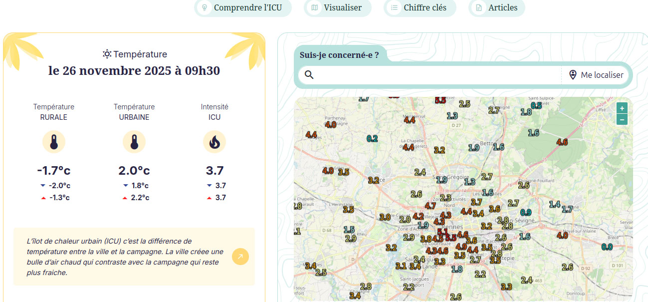
1. The first module “Understanding the ICU” (Comprendre l’ICU) familiarizes participants with the phenomenon and helps them better understand the data presented to them.
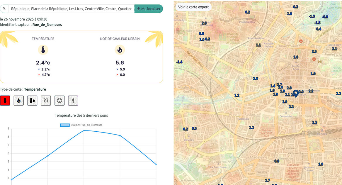
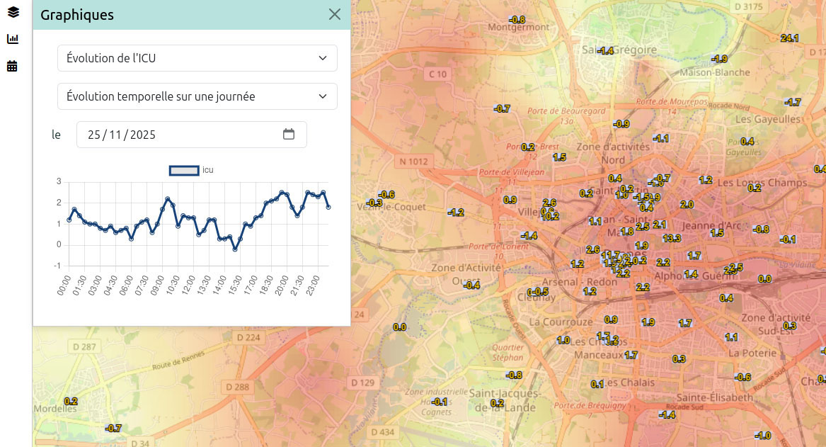
2. The “Visualize” module opens the map in full screen and allows you to select the indicator you want to display in real time: temperature, ICU intensity, humidity, and soon others. The “expert” mapping option provides access to maps created using the statistical method developed during the project, based on the coupling of sensor data and satellite imagery. More personalized queries can be made to the database to extract a specific time and date, a particular address, or even compare the temperature or heat island between two locations.
|
Standard visualization |
Expert mode visualization |
|
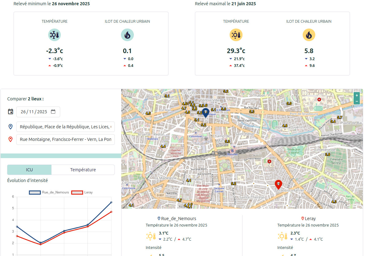
3. Additional information is available in the “Key figures” (Chiffres clés) module, where it is possible to compare temperatures and ICU intensity on two different dates for the same location. |
|
|
4. The participatory “Articles” module offers local and complementary information resources. These are integrated into the website directly by an authorized user from the region via a preformatted input interface. |
|
👉 Would you like to benefit from UrbaClim in your city? Contact Vincent Dubreuil and Arnaud Bellec here.
OUTLOOK
The project is a long-term undertaking and will continue beyond the planned timeframe. Thanks to various projects (City Orchestra, IRIS-E UMACC, Telkante Lab), ALTELYS will continue to evolve and grow stronger in the coming months, notably through:
- Continuing work:
- to refine the spatialization of the ICU
- to project the impact of development and/or greening scenarios
- Integrating:
- weather forecasts
- social and “One Health” indicators
- water stress and thermal comfort indicators
References
| ALTELYS on GEO Knowledge Hub, a long lasting digital repository created by the Group on Earth Observations: https://doi.org/10.60566/w4hyd-x8w93 |
- DUBREUIL V., FOISSARD X., NABUCET J., THOMAS A., QUENOL H., 2020 : Fréquence et intensité des îlots de chaleur à rennes : bilan de 16 années d’observations (2004-2019). Climatologie, 17 (6), p.1-17.
- DUBREUIL V., BRABANT C., DELAUNAY G., NABUCET J., QUENOL H., CLAIN F., LEPRINCE F., DREANO J., GEORGET L., 2022 : Rennes, une ville climato-intelligente ? L’IoT au service du suivi des îlots de chaleur. Editions Techniques de l’Ingénieur.
- AMORIM M.C.C.T., DUBREUIL V., AMORIM A., 2021 : Day and night surface and atmospheric heat islands in a continental and temperate tropical environment. Urban Climate. 38, 100918.
- AMORIM M.C.C.T., DUBREUIL V., 2017 : Intensity of Urban Heat Islands in Tropical and Temperate Climates. Climate, 5(4), 91.
-
BRABANT C., DUBREUIL V., DUFOUR S., 2024 : Evaluation of spatial interpolation techniques for urban heat island monitoring in small and medium sized cities. Frontiers in Built Environment. 10:1455047.
-
AMORIM M.C.C.T., DUBREUIL V., TEIXEIRA D.C.F., AMORIM A.T., BRABANT C., 2024. Exceptional heat island intensities also occur in medium-sized cities. Urban climate. 53, 101821.
Related projects
- RUN Rennes Urban Network website
- CAPES-COFECUB Sh 941/19 CiClAMEn (2019-2023): Cities, Climate And vegetation: Modeling and Environmental public policies. (UNESP, Presidente Prudente, Brésil ; LETG-Rennes).
- COST-FAIRNEss, UE-CA20108 - FAIR NEtwork of micrometeorological measurements.
- SCO projects:
Project news
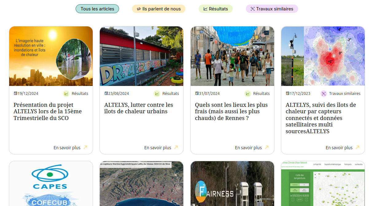
- 17/02/2026: UrbaClim, the citizen platform to combat urban heat islands
- 19/12/2024: Presentation of the ALTELYS project and its progress at the 15th SCO France Quarterly Meeting "Making the most of high-resolution imaging in the city: flooding and heat islands"
- 24/08/2024: ALTELYS, combating urban heat islands: installation of connected sensors in Brazil