

ECLAT Lake Chad

Project completed
As a further step from operational remote sensing to users, the ECLAT project has made it possible to conduct a study on public data in the remote sensing field, coupled with the capabilities of the Iota-2 chain to produce land use maps in extreme and complex environments. More importantly, it demonstrated the possibility of producing sustainable development indicators from open data and indices derived from spatial remote sensing.
OVERVIEW
Called Climate Change in the LAc Chad Region, the ECLAT project was initially built on this area because it was selected for ESA's Earth Observation for Sustainable Development (EO4SD) project as one of the four priority regions in the world for aid to fragile areas. While climate change is already one of the main drivers of fragility and conflict in the region, extreme variations in temperature and rainfall, as well as the frequency of floods and droughts, are expected to increase in the four countries around Lake Chad in the coming years. These events severely affect food security, lead to population displacement and further increase the risk of conflict and violence.
Thanks to exchanges with the GMES Africa programme, the African Union and the Ecological Monitoring Centre (Centre de Suivi Ecologique, CSE) in Dakar have become stakeholders in the project, which, in return for their needs, includes wetland monitoring.
Methodology
Using a multi-sensor satellite approach, the ECLAT project implemented a 3-step methodology:
1. Identification, evaluation and selection of calibration and validation databases
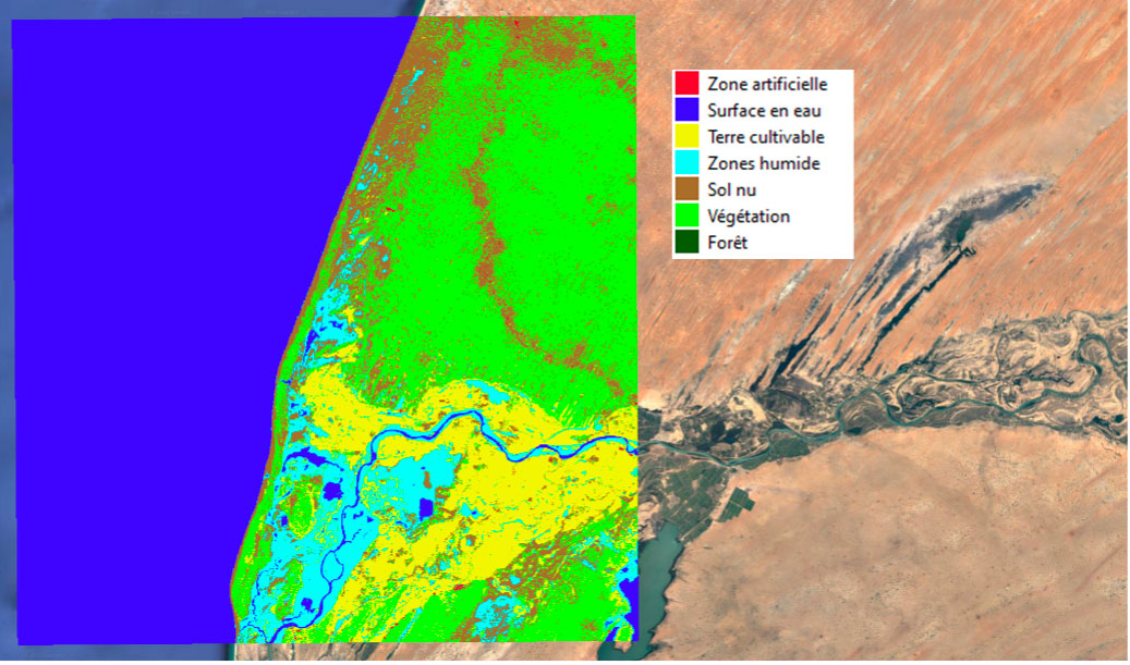
2. Production of land cover maps with the open-source chain Iota-2 (Infrastructure for Land Cover by Automatic Processing, based on Orfeo Toolbox (OTB), developed by CESBIO (Centre for Space Studies of the Biosphere, Centre d'études spatiales de la biosphère), in partnership with CNES
With a special focus on the following classes:
- Artificial surfaces
- Water surfaces and wetlands
- Bare ground
- Cultivated land
- Vegetation
- Forest
3. Development of sustainable development indicators
Application site(s)
- Lake Chad Basin region involving 4 countries (area of about 33 km2 ):
- Cameroon
- Niger
- Nigeria
- Chad
- Wetlands:
- Tocc Tocc Community Nature Reserve in Senegal (about 12 km2)
- W National Park straddling Benin, Niger and Burkina Faso (approx. 42 km²)
DATA
Satellite
- Sentinel-2
Other
25 freely accessible databases on the African continent covering the 3 study areas were analysed, and some of them were used to create maps and indicators.
RESULTS - FINAL PRODUCTS
1. Establishment of a replicable methodology;
2. Comprehensive evaluation and documentation of numerous thematic maps on Africa, providing a basis for future studies in Africa;
3. Production of land use maps;
Mapping land use in Senegal in 2020. SCO/ECLAT
4. Development of 3 sets of sustainable development indicators:
- Agriculture: indicators of land use and productivity to provide decision support in terms of monitoring changes, characterisation of plot use, estimation of seasonal production. In Senegal, the Ecological Monitoring Centre particularly appreciated this indicator for monitoring fallows, predicting plot rotation with regard to salinisation and leaching, and the possible overexploitation of agricultural land;
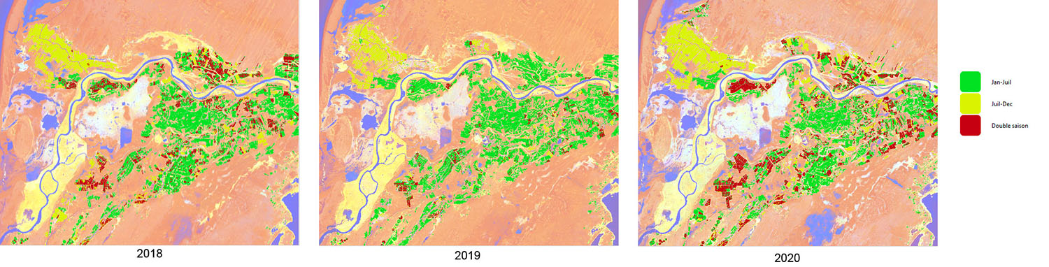
Figure 1: Monitoring changes in seasonal agricultural practices in Senegal. The year 2019 shows a collapse in double cropping and cultivation from July to December, a direct consequence of the drought that affected West Africa that year © SCO/ECLAT
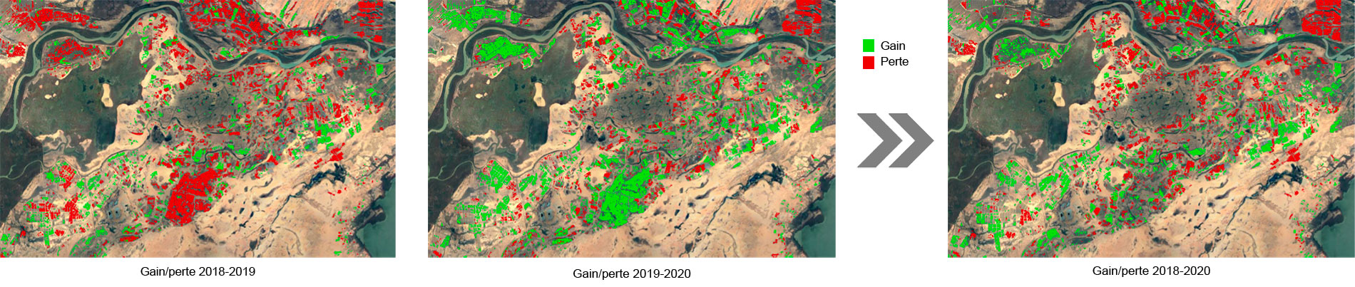
Figure 2: Interpretation of seasonal crop changes (Figure 1) as crop gains and losses in Senegal. These maps allow the potential impact on productivity to be assessed from one year to the next, but also allow anticipation of the year 2021, for example to target plots that need to be changed, stopped (for leaching, for example) or reoriented. Hectare data can be derived from these maps to give a more accurate picture of how much land is being gained or lost. © SCO/ECLAT
- Safeguarding water ecosystems: quantification of permanent and seasonal water surfaces to know the quantity of water present in the area, detect a potential impact (pollution) of nearby urban areas on water quality:
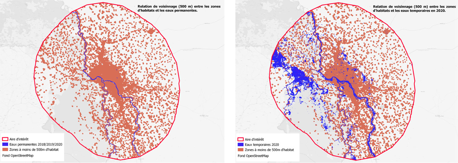
Estimated permanent (left) and temporary (right) water around the city of N'Djamena (Chad). © SCO/ECLAT
- Urban dynamics: the growth index developed reveals a trend towards urban sprawl and almost constant densification, particularly in the city of N'Djamena. In conjunction with the water ecosystems indicator, it strengthens the assessment of the impact of urban areas on the quality of nearby water areas.
5. The results of ECLAT studies were used to feed a service demonstrator developed in the framework of the CNES-AFD (French Development Agency) partnership aimed at evaluating the impacts on agro-hydrological development of a project to combat food insecurity in the N'Djamena region by re-watering a dead branch of the river, the Bahr Linia.
ECLAT data will also be able to feed UNESCO Water Quality Portal for Lake Chad, a project led by a French team including CNES in the framework of SWOT programme, IRD (Development Research Institute), OFB (French Biodiversity Office), INRAE (National Research Institute for Agriculture, Food and the Environment) and Magellium company.
The full detailed report of the project (102 pages, machine translation) and a summary abstract (4 pages, machine translation) are available for download in the Resources section below.
A link will soon be available to download the data generated by the project (in situ data and validation sets, land use data), which are already available on request from the contact form at the bottom of this page.
PROJECT NEWS
- 06/08/2021 : ECLAT: Climate Change in the Lac Chad Region
- 07/04/2022 : resentation of the ECLAT project and its progress at the 4th Quarterly Meeting of the SCO France on the theme "Water management and vulnerability of territories"