

EDISON
.")
EnhanceD emIsSiOn iNventory
Project completed Without access to data that is timely, reliable, up-to-date, and immediately actionable, local governments - despite their commitment - struggle to implement concrete measures to guide their public policies on air quality and environmental health.
After gathering the operational needs of a dozen cities in France and intermunicipal cooperation bodies (EPCI), the EDISON project developed a useful operational platform combining satellite data, atmospheric modeling, and territorial activity data, capable of providing a detailed, real-time view of NOx, CO2, CO, and PM2.5 emissions and their primary sources. Validated by expert users in the Nice metropolitan area, the solution has been successfully deployed in several international urban contexts (notably in Abidjan, Berlin, and Kavala, Greece), demonstrating its replicability on a global scale.
Overview
The EDISON project aims to improve air quality in France by enhancing existing inventories of atmospheric pollutants and focusing on emission sources. It is based on a monitoring tool combining satellite data (Sentinel-5P, Sentinel-3), existing inventories, atmospheric modelling, real-time data on activities (transport, buildings, industry, land use, etc.) and socio-economic data.
EDISON has thus enabled more accurate measurements, finer spatial resolution and greater speed for greenhouse gas emissions and air quality inventories, particularly for CO2 (carbon dioxide), NO2/Nox (nitrogen dioxide) and fine particles PM1/PM2.5. Municipal managers and regulators can thus visualize the impact of their activities on air quality and identify opportunities to reduce emissions.
Thanks to EDISON, decision-makers can plan priority actions to improve air quality in metropolitan France, based on accurate results and real-time data. In this way, the project is helping to combat air pollution and promote a healthier, more sustainable environment for all.
An innovative processing line
The processing pipeline developed as part of EDISON significantly improves the accuracy of measurements, spatial resolution, and the speed of emissions inventories. It relies on a combination of data sources: satellite data (Sentinel-5P for NO₂, Sentinel-3 for aerosols), existing emissions inventories, land-use data (road traffic, land cover, building energy consumption, industrial activity), and atmospheric modeling using the CHIMERE model, coupled with meteorological data.
Application site(s)
- Nice (France)
- Abidjan (Ivory Coast)
- Berlin (Germany)
- Kavala (Greece)
Data
Satellite
- Copernicus for measuring emissions :
- Sentinel 3 (SY_2_SYN and SY_2_AOD)
- Sentinel 5P (TROPOMI NO2L2)
- EGNSS for georeferencing, activity and socio-economic datasets, and existing emissions inventories based on declarative data.
Other
- Socio-economic: population groups, population density, economic sectors, etc.
- Activity data: land registry (Open Street Map), transport (Open Transport Map), traffic, energy consumption, land use, etc.
Results – Final product(s)
The EDISON project led to the creation and operational deployment of the GEMS (Global EMission inventory from Space) platform for monitoring and managing atmospheric emissions. This platform enables municipal managers, regulatory agencies, and local stakeholders to visualize, analyze, and take action on emissions of CO₂, NO₂/NOx, and fine particulate matter (PM2.5, black carbon, organic carbon).
Thanks to this platform, currently available in beta and accessible upon request (contact@waltr.fr), users now have a tool that allows them to:
Map hourly emissions with a spatial resolution of up to 500 meters, providing an accurate and localized view of pollution sources.
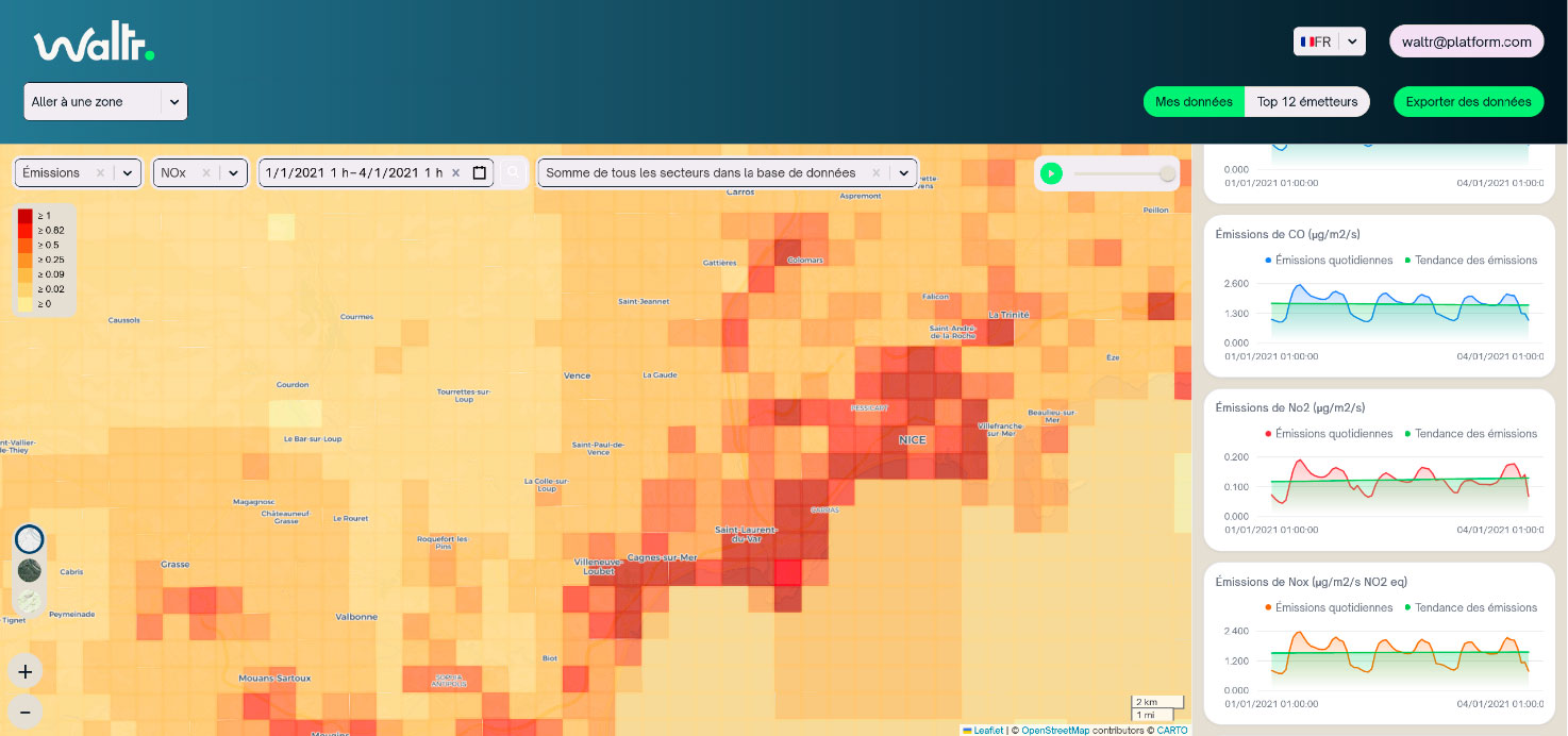
▲ Figure 1 - Example of a NOx emissions map for Nice and the surrounding area. © Waltr |
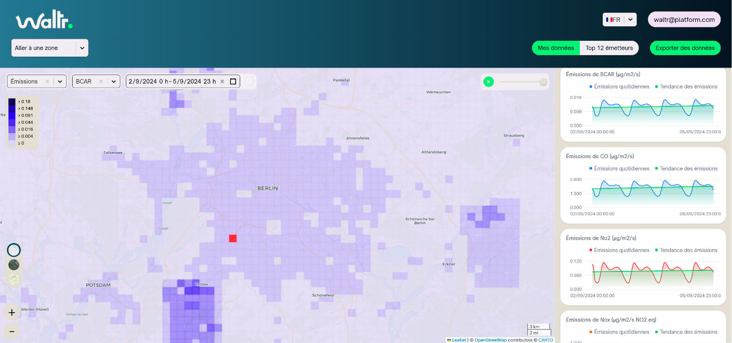
▲Figure 2 - Example of a map showing black carbon emissions in Berlin and the surrounding area. © Waltr |
Identify and track over time the major sources of emissions, including in hard-to-reach areas.
► Figure 3 - Examples of emission hotspots detected in Nice and the surrounding area. © Waltr | 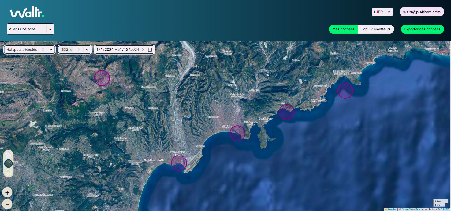 |
Simulate the impact of public policies (traffic restrictions, boiler conversions, etc.) and assess their effectiveness in reducing emissions and improving air quality.
Identify concrete measures to reduce emissions, tailored to local conditions.
► Figure 4 - Visualization of emission zones in Nice and the surrounding area, which can be used for scenario planning. © Waltr | 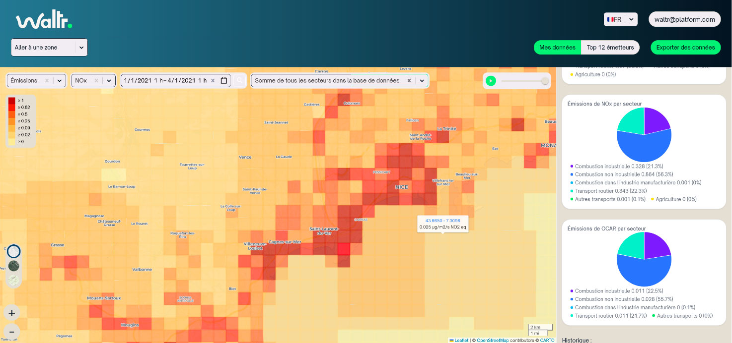 |
Compare performance across different regions (metropolitan areas, rural areas, international cities) and track changes in pollution hotspots over time.
► Figure 5- Example of a refinery identified and monitored as an emissions hotspot. © Waltr | 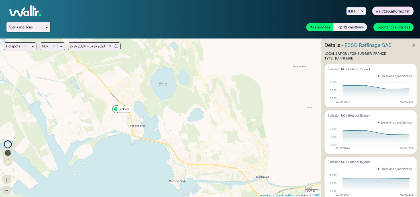 |
👉 Initially deployed in the Nice metropolitan area, the platform has demonstrated its scalability and replicability on an international scale, with implementations in Abidjan, Berlin, and Kavala. These deployments have validated the robustness of the processing chain and confirmed its potential to support urban planning and the management of regional climate, air, and energy plans.
Outlook
EDISON addresses a critical need for local governments: access to accurate, up-to-date, and objective data to guide their climate, air quality, and energy policies, which are often constrained by long political cycles and limited budgets. Unlike ground-based monitoring networks, which are costly and limited to major urban centers, EDISON offers a cost-effective, flexible, and scalable solution capable of covering under-monitored areas (rural areas, mountains) and adapting to regional specificities.
Ultimately, the project aims to expand its scope to other pollutants (NH₃, SO₂, VOCs) and to integrate additional data to further refine the accuracy of inventories.
EDISON thus serves as a key driver for the ecological transition, providing decision-makers with the tools needed to take targeted, effective, and transparent action in support of cleaner air and a protected climate.
Related project(s)
- SCO AEROLAB SPACE
- SCO FLORIA
Project news
- 🎥 18/06/2026: Presentation of the EDISON project and its progress at the 21st Quarterly Meeting of SCO France “Air Quality: A View from Space”
- 23/09/2024: Presentation of the EDISON project and its progress at the 14th SCO France Quarterly Meeting "Monitoring air quality from space"
- 19/06/2024: EDISON: air quality is a question of scale