

FLORIA

Flexible algORIthm for the monitoring of Air pollution based on artificial intelligence and satellite observations
Project completedPM10 particles, defined as atmospheric particles with a diameter of less than 10 micrometers, are a key indicator of air pollution, with significant impacts on health and the environment. Conducted from February 2025 to March 2026, this project enabled the industrialization of THALES Digital Services’ FLORIA solution and validated its performance through several concrete use cases in partnership with World from Space. The work resulted in the implementation of an operational service capable of producing PM10concentration maps on a European scale, as well as the scientific evaluation of the data produced.
Overview
It is now well established that pollutant emissions are a major problem for the climate and our health. For the past two decades, level 2 satellite products (instantaneous products acquired during a single satellite pass) have been used to try and extract information on the concentration of pollutants at the surface. But the complex links between the data measured by the satellite from its orbit and the concentration of pollutants at the surface make these methods difficult to generalize. To take account of this complexity, numerical models such as CHIMERE (transport chemistry) and MOCAGE (large-scale atmospheric chemistry) used in the Prév'Air and CAMS platforms can simulate the atmosphere, the physico-chemistry and the transport of gaseous pollutants and fine particles, but they require significant computing resources, which makes them difficult to access.
To overcome these various difficulties, our innovative idea involves tackling the complexity of the physico-chemical model using a statistical approach based on artificial intelligence (surrogate model) coupled with satellite data. The added value of this solution is to offer continuous monitoring of air quality on a large scale, including areas with little in-situ sensor coverage.
Among the different types of pollutants, we propose to characterize and monitor PM10 concentrations at the surface, in order to respond to the feedback loop initiated by climate change:
- The increase in extreme weather events (heatwaves) and natural disasters (fires) is changing the mechanisms by which PM10 is formed, transported and deposited, and therefore the type of pollution events.
- This modulation of PM10 pollution events and its associated radiative effects in turn influences climate change.
Project Timeline
1. Service Industrialization
An automated processing pipeline was developed and deployed on a cloud infrastructure, enabling the daily generation of PM10concentration maps. This phase transformed a scientific prototype into a robust, scalable, and operational service.
2. Use Case Analysis
Two studies were conducted to assess the utility of the service for specific issues:
- the impact of urban heat islands on PM10 concentrations,
- the impact of road traffic density on air pollution.
This work made it possible to compare the generated data with real-world situations and to determine the potential scope of application for the FLORIA tool.
Methodology
FLORIA is based on a surrogate model approach, which makes it possible to reproduce the behavior of complex physicochemical models at a reduced computational cost.
The processing workflow includes:
- the aggregation of satellite and meteorological data,
- a preprocessing and spatial tiling,
- a parallelized artificial intelligence inference,
- a final aggregation to produce continuous PM10 maps.
The system was deployed using a cloud-native architecture (Kubernetes, automated workflows), enabling robust and scalable daily operations.
Application site(s)
- Spain
- Czech Republic: Prague, Brno and Pilsen regions
Data
Data used by the algorithm:
Satellite
- Sentinel-3 (L2 AOT products)
Other
Weather parameters:
- Reanalyses (historical) from ERA5
- Forecasts from the ICON-EU model
Additional data for use cases:
- Use cases related to heat islands:
- In-situ PM10 (Czech Hydrometeorological Institute (CHMI) network, hourly averages)
- Heat stress indicators (ERA5)
- Land cover (ESA WorldCover)
- Surface temperature (Sentinel-3 SLSTR)
- Road traffic use cases:
- In-situ PM10: 4 CHMI stations (hourly observations)
- Road traffic: municipal open data (sensors, hourly counts, city-wide aggregation)
- Weather: ERA5 reanalysis (temperature, humidity, wind, precipitation, boundary layer)
Results – Final product(s)
🗺️ Deliverables
The project has produced the following deliverables, covering the period 2021–2025:
- A database of surface PM10 concentrations across Europe
- Resolution: 4 km × 4 km
- Frequency: daily
- Monthly PM10 concentration maps accessible via a web interface (august 2025 – february 2026)
- Usable files in NetCDF format
🌐 Visualization platform
A web interface allows you to view monthly pm10 maps: https://floria-dev.pf-services-bu-aes.fr/
👉 Features:
- Interactive visualization (zoom, navigation),
- Display of values (latitude/longitude/concentration),
- Map downloads.
👉 Access conditions: open access for viewing monthly maps; detailed data may require specific access or a partnership.
► Monthly maps produced from august 2025 to February 2026 covering Europe and north Africa. © THALES SN | 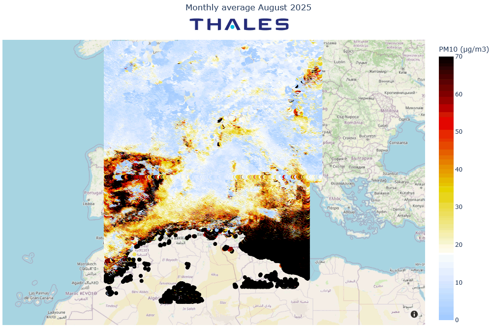 |
🏭 Industrialization
The operational validation phase demonstrated the industrial maturity of the service. Indeed, over a six-month trial period, the system maintained a success rate of over 90% in executing daily workflows. The implemented architecture combines industrial robustness, scientific flexibility, and technological scalability, notably thanks to Kubernetes orchestration, containerization, and managed cloud services.
📊 Performance validation
The results were validated in Spain and the Czech Republic in partnership with World from Space.
- AOD validation (Sentinel-3 vs. AERONET): the satellite product is considered robust for aerosol monitoring (correlation: r ≈ 0.73)
PM10 validation (FLORIA vs. CHMI stations): performance consistent with the limitations of satellite estimates, particularly those related to the complexity of atmospheric phenomena and local variability. Calibration incorporating meteorological variables significantly improves the results.
🧪 Use cases
1. Impact of urban heat islands on PM10 concentrations:
Results from in-situ data show that heat waves are associated with a measurable increase in the urban-rural contrast of pm10 concentrations in the Czech Republic. This amplification is more pronounced during daytime than nighttime. These observations suggest that the meteorological conditions associated with heat waves promote the accumulation of particles in urban environments.
The FLORIA satellite product, however, is limited by sampling issues for this use case (cloud cover, validity of estimates, satellite pass timing).
2. Impact of road traffic on air pollution:
Conducted in the city of Ostrava, the study highlights a clear relationship between traffic density and PM10concentrations. After correcting for meteorological effects (normalization), FLORIA consistently captures the variability in concentrations linked to traffic. The results show that an approach combining satellite data, in situ measurements, and meteorological normalization allows for the identification of a robust signal at the urban scale.
👉 This work demonstrates the value of FLORIA for:
- Analyzing the impacts of climate change,
- Urban planning,
- Public decision-making support, particularly for evaluating traffic management policies.
Outlook
Several avenues will help improve the performance of the FLORIA service.
The use of geostationary satellites would offer better temporal resolution, allowing for better tracking of rapid pollution events. Downscaling approaches could also refine spatial resolution and better represent urban contrasts.
Furthermore, the integration of new-generation sensors, such as Sentinel-4 on MTG and 3MI on Metop-SG, as well as model improvements using meteorological data, represent promising avenues for enhancing the accuracy of estimates.
References
J. Staufer, C. Rakotondrainibe, J.-C. Péré, B. Gratadoux, J. Cuesta, G. Dufour, S. Tanguy, L. Chaumat and L. Le Barbier (2024) : Monitoring of gound-level pollutants concentrations from space, ESA ATMOS Conference, 1-4 July 2024, Bologna Italy, ATMOS 2024
Related project(s)
SCO EDISON, Improving the inventory of urban air pollutants
Project news
- 🎥 18/06/2026: Presentation of the FLORIA project and its progress at the 21st Quarterly Meeting of SCO France “Air Quality: A View from Space”
- 21/04/2026 : FLORIA, or how to read the air we breathe
- 25/09/2025 : FLORIA : The map of PM10 pollutants in Europe is online