

SCOFrance
PartnersTHALES Services Numériques, World from Space, CNES
Useful linksProject page
KeywordsPM10, pollution and air quality, automatic processing
FLORIA, or how to read the air we breathe

The evidence is clear: in the current context of climate change and extreme events (heatwaves, wildfires, etc.), the intensification of air pollution episodes, linked to human activities and natural disasters, has major impacts on public health and the climate. Understanding the close links between pollution and climate has become essential for guiding public policy and adaptation strategies.
Focusing on PM10 atmospheric particles (with a diameter of less than 10 micrometers), which are a key indicator of air pollution, FLORIA builds on a previous R&D phase by THALES Digital Services (THALES Services Numériques) to move into the industrialization phase. “Faced with the complexity of linking satellite measurements to ground-level concentrations and atmospheric chemistry models - which, whilst effective, are highly computationally intensive - we have developed an innovative statistical approach based on artificial intelligence (surrogate model) coupled with satellite data,” explains THALES SN.
The result: automated and operational production of daily PM10 concentration maps
Developed on the THALES platform, the FLORIA service is based on an automated – and scalable – processing chain that generates daily PM10 concentration maps from Sentinel-3 satellite data.
► Monthly maps, generated by aggregating these daily products, are made freely available for Europe and North Africa from August 2025 to February 2026 (read here). THALES SN confirms: “With a success rate of over 90% on for daily calculations during these seven months of testing, the cloud infrastructure has demonstrated its robustness and maturity. Furthermore, we have designed it to be scalable to other pollutants, notably PM2.5.” | 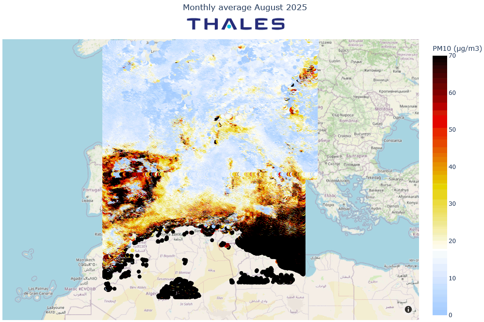 |
| 👉 Now operational, the FLORIA space service can thus provide continuous, large-scale air quality monitoring – a promising solution for providing data in areas with few in-situ measurement instruments. | Interested in a demo? 🎥 Watch the replay of the June Quarterly Meeting, in which the FLORIA project participated. |
Putting it to the test in the field
To verify the accuracy of the results (over the 2022–2024 period), Thales SN has partnered with World from Space, a Czech company specializing in satellite data analysis.
In Spain, the Sentinel-3 AOT satellite products used by FLORIA were compared with in situ measurements from the AERONET network. The results show that the satellite product is generally reliable for regional aerosol monitoring.
In the Czech Republic, it was this time the FLORIA outputs that were compared with in situ measurements from 87 stations in the CHMI network. Here, the performance of the satellite estimates is more mixed: whilst the general trends are reproduced, discrepancies remain in terms of amplitude and dynamics. However, the integration of meteorological variables significantly improves the results.
Taking it further: two use cases
To assess the scope of application of FLORIA data, World from Space tested them in two use cases.
🌇 Firstly, across the whole of the Czech Republic, to assess the impact of urban heat islands on PM10concentrations from 2020 to 2024. Based on 20 pairs of urban/rural stations (no more than 50 km apart), ground-level measurements clearly show that during heatwaves, cities accumulate more particulate matter than rural areas, particularly during the day.
👉 Due to the limited number of satellite passes, which are insufficient to capture the full dynamics, FLORIA does not clearly reflect this contrast.
🚘 Next, in Ostrava, a busy industrial and urban center in the north-east of the Czech Republic, to assess the impact of road traffic on air pollution in 2024. Here, the influence of road traffic is clearly evident in the PM10 time series, with consistently higher concentrations on days of heavy traffic: +3.5% according to in situ data, +4% according to FLORIA outputs.
👉 The good agreement between ground-based measurements and FLORIA estimates shows that the satellite product consistently captures the variability in PM10 concentrations linked to traffic intensity, when meteorological influences are properly controlled.
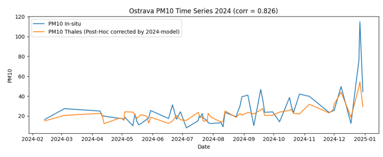 |
◀︎ In-situ PM10 (in blue) vs post-processed Thales PM10 (in yellow) over Ostrava in 2024. © THALES SN |
Outlook
With the industrialization of its automated processing chain, FLORIA has transformed a scientific prototype into a robust and scalable operational service for large-scale satellite monitoring of PM10.
While the results of the use cases may prove less concrete than hoped for, “they demonstrate that an approach combining satellite data, in-situ measurements and meteorological normalization enables the identification of a robust signal at the urban scale. They also have the merit of identifying satellite limitations in terms of spatial and temporal resolution, providing valuable insights for exploring new avenues. The story continues to unfold in R&D,” emphasizes the project lead. Thales SN therefore plans to explore the use of geostationary satellites, which would offer better temporal resolution for tracking rapid pollution events. In the future, data from next-generation sensors, such as 3MI on Metop-SG, should also help improve the accuracy of estimates.
See details of the methodology and results on the project page