

EO4AWD

Earth Observation for Alternate Wetting and Drying
Overview
In Thailand, rice cultivation emits the largest amount of CO2eq within the agriculture sector from the inundated practices in the rice fields during cultivation leading to methane emission. The Alternate Wetting and Drying (AWD) technique offers a sustainable alternative, demonstrating the potential to reduce methane emissions and irrigation water usage by 15–35%.
This project leverages satellite imagery and remote sensing techniques to assess the water regime implemented in rice paddies and quantify the potential reduction of emissions from the continuously flooded baseline. The project will utilize optical and SAR imagery, both C-band and L-band, to capture rice phenological stages and to classify water regimes using machine learning models.
This information will allow the estimation of methane emissions from rice paddies. This initiative supports Thailand's commitment to climate change mitigation by promoting sustainable agricultural practices and enabling farmers to access carbon markets.
Furthermore, through collaboration with GlobEO, this project can leverage their experience applying similar methodologies in the Mekong Delta (SCO Mérimée Project*), adapting them to the specific context of Thailand.
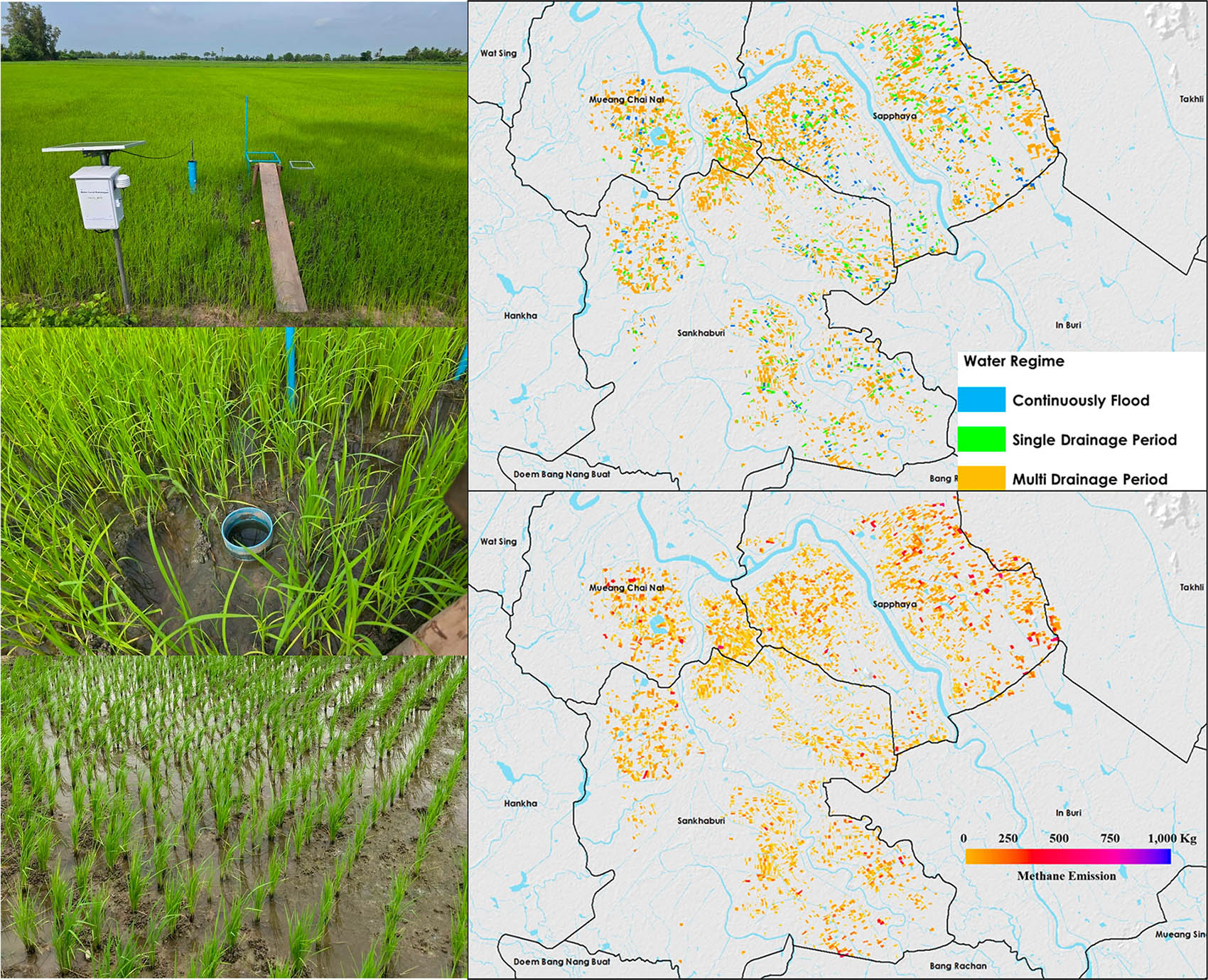
|
The project integrates ground-based observations with satellite data to monitor the irrigation cycle, enabling spatial and temporal mapping of methane emissions. © GISTDA |
|
Application site(s)
Thailand irrigated rice areas in central cultivation plain
Data
Satellite
- ESA’ Copernicus Sentinel-1satellites for C-band SAR radar data for the detection of rice planting areas, growth cycle, and presence of water at early rice stages.
- JAXA's ALOS-2-PALSAR-2 satellite for L-band SAR radar data for detecting the presence of water under rice canopy.
- GISTDA’s THEOS-2 satellite for high resolution optical data.
Other
- Ground-truth data from surveys and IoT devices, including water levels and methane sensors from pilot areas.
Results - Final product(s)
The project aims to develop algorithms and provide users with product for measuring mitigation strategy to reduce methane emission from rice cultivation. The final products will include:
🌾 A rice inundation status map that provides a season-long estimation of irrigation regimes across rice paddies.
💥 A methane emission map that estimates the level of emissions associated with varying irrigation management practices.
👉 A dashboard for Monitoring, Reporting, and Verification (MRV), which will be integrated into GISTDA’s agricultural digital platforms, such as DragonFly and AIP-Climate Resilient Agriculture.
Moreover, the produced dataset will be service-ready data that can be accessed and integrated into other applications, allowing for the use of evidence-based information in other contexts.
References
Arai, H., Le Toan, T., Takeuchi, W., Oyoshi, K., Fumoto, T., & Inubushi, K. (2022). Évaluation de l'état de l'irrigation dans le delta du Mékong grâce à l'assimilation de données SAR polarisées en bande L. Télédétection de l'environnement, 279, 113139.
Related project(s)
- 🇹🇭 DragonFly, a digital agricultural system at the plot level. Utilizing precise and modern space technology and geoinformatics,it is designed to help farmers monitor, observe, predict, and access dynamic data for timely decision-making.
- 🇹🇭 Actionable Intelligent Policy (AIP) for Climate Resilient Agriculture, a policy-support tool that utilize satellite-based and spatial data to simulate adaptation and mitigation strategies in rice-growing areas.
- 🇫🇷🇻🇳 VietSCO Mérimée, a dynamic mapping of rice-related methane emissions in the Mekong Delta (Vietnam)