

Mérimée

Mekong Rice Methane Emissions
Overview
Context
In the Mekong Delta, a major rice production and export region in the world, phenomena such as flooding, drought, saline intrusion, erosion and subsidence are intensifying. These phenomena are affecting the lives of local people and their livelihoods, as well as the food security of Vietnam and the rest of the world.
As part of the VietSCO project (2020-2022), we have developed operational tools that provide regularly updated geospatial information to support decision-making on measures to adapt to phenomena linked to climate change. These tools are:
- monthly monitoring of rice-growing areas,
- monitoring crop growth stages,
- annual monitoring of the number of harvests per year per rice field, and
- monitoring the extent of flooding during the wet season.
The data and products developed are distributed free of charge via the VietSCO online platform https://www.vietsco.org/.
Users and stakeholders in Vietnam were keen to go further and provide the information needed for the low-carbon strategy for rice growing - a priority for the country. Indeed, at COP26 in 2021, Vietnam joined 102 countries in signing a commitment to reduce methane emissions by 30% by 2030, compared with 2020 levels. Globally, the methane emitted by rice paddies accounts for around 1.3% of all man-made greenhouse gas (GHG) emissions (compared with 2% of all emissions from civil aviation). Reducing emissions from rice paddies is therefore included in all global GHG mitigation programmes.
|
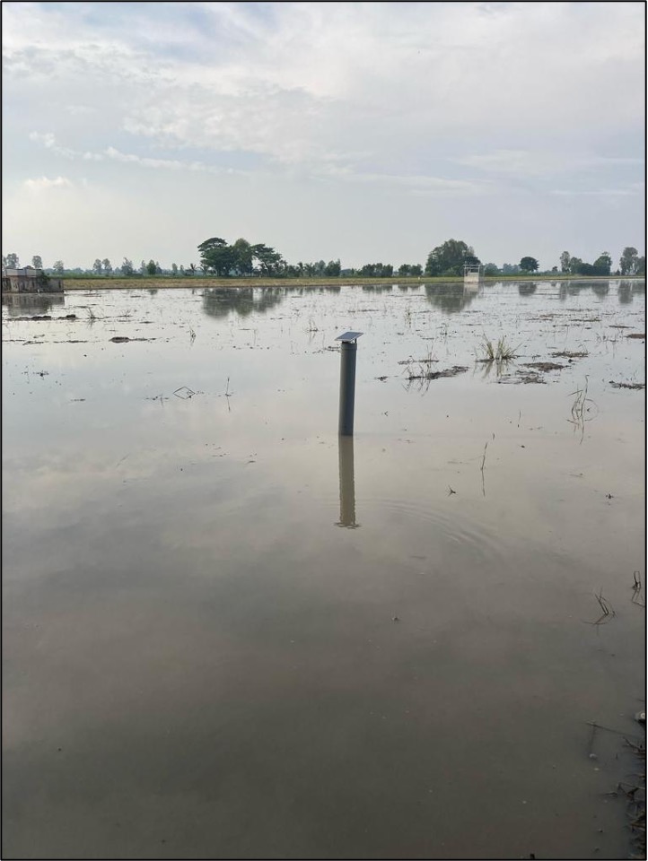
The most promising mitigation strategy is recognized as being the improvement of water management in rice production. Traditionally, rice fields are permanently flooded during the water cycle. Practices such as Alternate Wetting and Drying (AWD) have been shown to reduce methane emissions by 40-60%, without affecting rice yields (Arai et al., 2022). They also enable farmers to save water, especially in the dry season. ▶︎ Installation of water depth sensors powered by solar panels in rice field. © Thuy Le Toan, Nguyen Lam-Dao |
|
Objective
At present, AWD practices have been initiated but are not widely adopted. To help the government, the aim is to provide dynamic maps of the irrigation status of rice fields (continuous irrigation or AWD), making it possible to locate efforts to encourage and develop AWD infrastructure throughout the delta. This information will also be useful to non-governmental organizations, companies and international bodies seeking to finance farmers and local authorities via low-carbon incentive credits. These maps will enable dynamic mapping of methane emission estimates.
Method
Radar data (ALOS-PALSAR, Sentinel-1) will be used to detect the type of irrigation, and methane emissions will be estimated using empirical methods based on in-situ data and modelling (DNDC model), combining information on the state of plant growth, irrigation practices and climatic information.
Application site(s)
Mekong Delta, Vietnam
Data
Satellite
-
Sentinel data from the Copernicus programme, freely available. Due to frequent cloud cover, the main source of data will be Sentinel-1 radar imagery, acquired every 6 days with Sentinel-1A and soon 1C, with a resolution of 10m.
-
Radar data from JAXA's ALOS-2-PALSAR-2 satellite: L-band SAR data that provides better wave penetration in the canopy. As a result, the presence of water under the plants can be detected throughout the rice growth cycle, whereas with Sentinel-1's C-band radar, the presence of water is not detectable when the plant is in full development (between 40 and 60 days). Collaboration with JAXA in the Asia-Rice initiative means that the project team has access to all ALOS-2 PALSAR-2 images over the Mekong Delta (Arai et al., 2021).
-
Very high-resolution optical data obtained thanks to the DINAMIS initiative.
Other
-
The in-situ data will be experimental data on rice cultivation, collected by Vietnamese partners - VNSC in Ho Chi Minh City. For methane emissions, the experimental data will be defined and shared with the IRRI-Vietnam teams.
-
In terms of infrastructure, the project will benefit from the experience of the VietSCO project: CNES PEPS and HAL, CESBIO/GlobEO infrastructure.
Results – Final product(s)
The aim of the project is to provide users with new decision-support products for implementing the country's low-carbon strategy, in particular maps for estimating methane emissions, as well as products for use by users from various backgrounds, such as coastal vulnerability products. These products will be made available on the existing VietSCO platform.
References
Arai, H., Le Toan, T., Takeuchi, W., Oyoshi, K., Fumoto, T., & Inubushi, K. (2022). Evaluating irrigation status in the Mekong Delta through polarimetric L-band SAR data assimilation. Remote Sensing of Environment, 279, 113139.
Related project
VietSCO :
- Online platform: https://www.vietsco.org/
- Vimesco-Rice project
- Viet-ARRO project
Project news
-
🎥 23/06/2025: Presentation of the Mérimée project and its progress at the 17th SCO France Quarterly Meeting
-
31/03/2025: VietSCO Mérimée presents its first results in Vietnam
-
14/05/2024: VietSCO on the methane attack with Mérimée